Teurnia: A Roman Provincial Capital and Episcopal City in Austria

Site at a Glance
- Rating
- 4.6
- Popularity
- Low
- Country
- Austria
- Primary era
- Classical
- External website
- Open
- Eras represented
- Classical, Medieval
- Civilizations
- Celtic, Roman
- Site type
- City
On this page21 sections
History
Teurnia is an ancient Roman city in Austria, built by the Romans on the Holzerberg in present-day St. Peter in Holz. Established as a municipium, a Roman town whose inhabitants held civic rights and whose government followed Roman municipal structures, around AD 50 under Emperor Claudius, it developed into one of Noricum’s leading cities. In late antiquity it became the capital of Noricum mediterraneum, the inland southern part of the Roman province of Noricum, and the seat of a Christian bishop.
Before and during Roman rule
The Holzerberg had been occupied by about 1100 BC. Finds from the Hallstatt and La Tène periods show that the area belonged to a Celtic cultural and tribal region, although intensive Roman construction removed direct settlement remains from those earlier phases. After the Celtic kingdom of Noricum was incorporated into the Roman Empire around 15 BC, the settlement was gradually Romanized. Timber buildings in the HA area and the western burial area belong to this early Roman phase.
Teurnia’s formal development as a Roman town began around AD 50. Its forum and other urban facilities supported civic and commercial life, while workshops for metalworking and probably textile production point to economic prosperity. At its greatest extent, the city may have had as many as 30,000 inhabitants. The settlement spread across the hilltop, its terraces, and parts of the surrounding plain, making use of the fertile landscape beside the Drau.
Provincial importance and late antiquity
Teurnia eventually became the second capital of Noricum after Virunum. The change is associated with growing threats to Italy and worsening security conditions. Teurnia’s hilltop position and its newly built defensive circuit probably helped make it a suitable administrative centre. In the later Roman period, settlement contracted from the residential terraces onto the more defensible summit of the Holzerberg.
By the fourth century, Teurnia, then known as Tiburnia, was a Christian town and a bishop’s seat. The Bishop’s Church probably served the Catholic community, while the Memorial Church may have been used by Arian Christians, who rejected the doctrine that Christ was fully equal in status to God the Father. This possible division reflects the varied Christian communities of the late Roman world.
Bishop Paulinus of Tiburnia appears in Eugippius’s Life of Saint Severinus. The inhabitants persuaded Paulinus to accept episcopal office, and during a Gothic siege they secured the city’s release by paying tribute in clothing. Bishop Leonidas is also associated with the city. These references place Teurnia within the ecclesiastical and political struggles of the final Roman centuries.
Decline and abandonment
The city’s final centuries brought economic decline and a reduction in occupied space. Slavic populations probably reached the area during this period. Urban occupation ended in the sixth or early seventh century, and Teurnia was probably abandoned around AD 610. Early medieval finds suggest a possible connection with the royal estate known as Lurn or Liburnia.
Pliny the Elder and Ptolemy both listed Teurnia among the cities of Noricum. Later historians knew the ancient name from written works from the sixteenth century onward, but the location remained uncertain. Building materials from antiquity were reused in nearby houses and at Porcia Castle in Spittal. The Jesuit Markus Hansiz eventually identified the Holzerberg with ancient Teurnia. The ancient name also survives in Tiburnia, a Catholic titular archiepiscopal see established in 1968. A titular see preserves an ecclesiastical title without functioning as an active territorial diocese.
Excavation and presentation
Targeted excavation began in 1845 at the commission of Prince Alphons Seraphin von Porcia. Michael Franz von Jabornegg-Altenfels prepared early plans and systematically recorded inscriptions and reliefs. Further work followed under Fritz Pichler and the parish priest Gabriel Lex in 1876 and 1877.
A water-conduit project led to the accidental discovery of the Memorial Church in 1908. The Austrian Archaeological Institute excavated it in 1910 and 1911 under Rudolf Egger, who later investigated the Forum Terrace, the hilltop, parts of the late antique houses, and the city wall. Excavations on the eastern residential terraces began in 1971 under Gernot Piccottini. Franz Glaser directed the work from 1975, including investigations of the residential terraces, the HA buildings, the Memorial Church, and the Bishop’s Church, which was discovered in 1984. His work also included anastylosis, the reconstruction of a building with surviving original elements, and the development of the museum area.
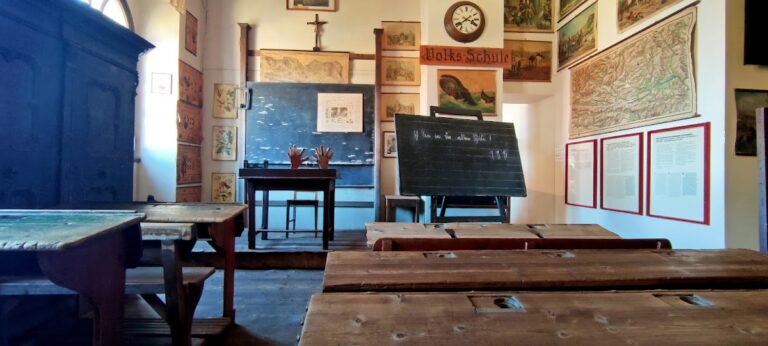
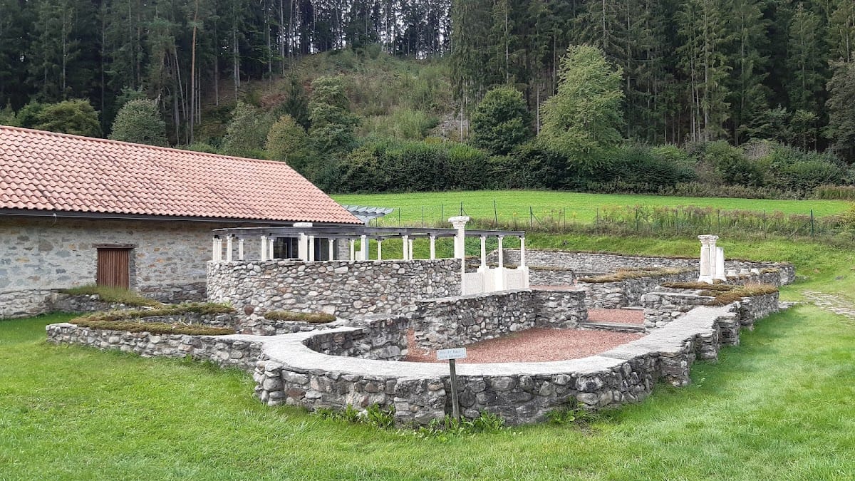
The Römermuseum Teurnia, a branch of the kärnten.museum, presents finds from the urban area. The first Roman museum opened above the Memorial Church’s entrance hall in 1924. A purpose-built museum beside the church was completed in altered form in 1960, and a new museum was established in a former parish barn from 2000 onward. The Friends of Teurnia association and Kuratorium pro Teurnia continue to support archaeological and museum work. The Bishop’s Church, the Memorial Church, and the late antique house in Area HA are presented on site, while the excavated residential terraces and parts of the Forum have been reburied or built over.
Remains
Teurnia occupied a river-margin terrace in an Ice Age landscape directly north of the Drau. The approximately 620-metre-high Holzerberg rises about 70 metres above the valley settlement and has a steep southern slope. The Roman settlement extended across the plateau, the terraced southeastern slopes, and adjoining lowland. The upper city followed the summit, while substantial terraces supported construction on the southern slopes. Its loosely arranged streets and buildings followed an orthogonal alignment, and archaeological survey has identified a Roman road settlement on the western side of the hill.
Urban centre and public buildings
Forum
The Forum occupied a raised terrace above the residential districts. Its rectangular space measured about 65 metres in length and between 26 and 29 metres in width. Marble slabs paved the square, which was decorated with honorary monuments and bordered along its long sides by porticoes. An apsidal room on the northwest side is interpreted as a curia, a civic meeting chamber for the town council. The original entrance probably stood on the south, while a main road crossed the northern part. The higher northern end has been altered by modern construction.
Bath complex
A Roman bath stood south of the Forum, with its southern side facing the Drau. Its rooms followed the usual bathing sequence from the heated caldarium to the warm tepidarium and then the cold frigidarium. Two apses marked the river-facing side, and the entrance lay on the east. Substructures and excavation records indicate two building phases, with the bath probably constructed in the third century AD.
The water system included large containers north of the caldarium and against the rear wall of the frigidarium. A cistern is suspected on the southeastern side. Other water installations across Teurnia included shaft wells, two cisterns near the Forum, and channels in both the Forum and eastern residential area.
Possible sanctuary
A building inscription discovered in 1977 led to the proposal of a sanctuary for Grannus Apollo, a Celtic healing deity whom the Romans associated with Apollo. A spring east of the parish church supported this interpretation, since Grannus was worshipped as a healing god. Excavations in 2014 revealed only slight wall remains, so the sanctuary identification remains possible rather than certain.
Residential districts
Eastern terraces
The eastern residential terraces lay on the Ertlfeld at the foot of the Holzerberg. The houses were connected by a road about six metres wide, bordered on its eastern side by a terracing wall. Excavation has covered only part of the lower terraces, but aerial photography and geophysical survey show that the built area continued eastward and southward.
The houses were occupied from the first through the third century AD and may have remained in use into the fourth century. Some had wall paintings and passed through at least two construction phases. After the houses were abandoned, graves were inserted into their ruins during the fifth and sixth centuries.
Area HA
Area HA, northeast of the museum, contains conserved remains of a late antique town house. Early imperial timber buildings were apparently replaced by structures with simple stone foundations after the city’s Roman foundation. A fire at the transition from the second to the third century AD was followed by a period without residential construction, which ended when new houses were built in the mid-fourth century.
The nearly square building HA 2 appears to have begun as a single-room structure with an upper storey. Additional rooms were added to its central building in the late fifth century. An apsidal room, a hypocaust, or Roman underfloor-heating system, and fragments of marble columns indicate a representative residence. Ceramic finds show that HA 2 continued in use into the seventh century.
Water installations
A spring rising in the southeastern hill area helped sustain the settlement. Roman waterworks included shaft wells in Area HA and beneath the imperial-period house below the Memorial Church. Two cisterns were excavated near the Forum, and channels were found in the Forum and eastern residential area. A wall crossing the Lendorfer Moos probably carried an additional water supply from the Lendorfer Bach.
Late antique fortifications and churches
City wall
The late antique wall enclosed the summit of the Holzerberg. It survives mainly on the northwestern and northern sides, while landslides destroyed much of the southern section above the Drau. The wall was built of cast masonry set against the slope on the interior and faced externally with river pebbles. Surviving sections reach about 2 to 2.5 metres in height.
Fragments of marble funerary monuments and pieces of late antique pottery were incorporated into the wall. These reused materials indicate that the circuit was probably constructed around AD 400 rather than belonging to the city’s original Roman plan. The west gate formed part of this defensive system.
Bishop’s Church
The Bishop’s Church was first built around AD 400 as a single-nave church ending in an apse. A free-standing bench for the clergy stood inside, accompanied by a screen made from slabs, upright elements, and small columns. A reliquary was sealed by a marble slab.
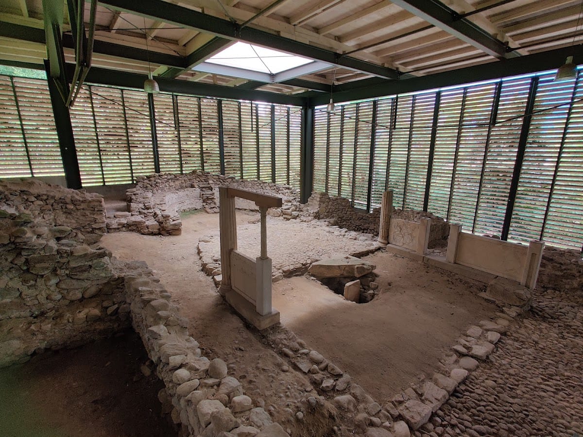
After a destructive fire, the church was probably rebuilt in the sixth century as a basilica with a triconch plan, a design organized around three apsidal arms. Open halls ran along its long sides. Surviving wall paintings show women wearing Byzantine court dress. An associated hospitium, or lodging building, was excavated to the northeast, and a protective shelter covers the church remains.
Memorial Church
The rectangular Memorial Church stood in the western part of the settlement. It was a hall church with a free-standing clergy bench. Two transverse annexes attached to the nave created a Latin-cross plan, while chapels were added to the eastern ends of the annexes. A narthex, an entrance hall at the western end of an early Christian church, stood beyond the nave and was entered through side doorways.
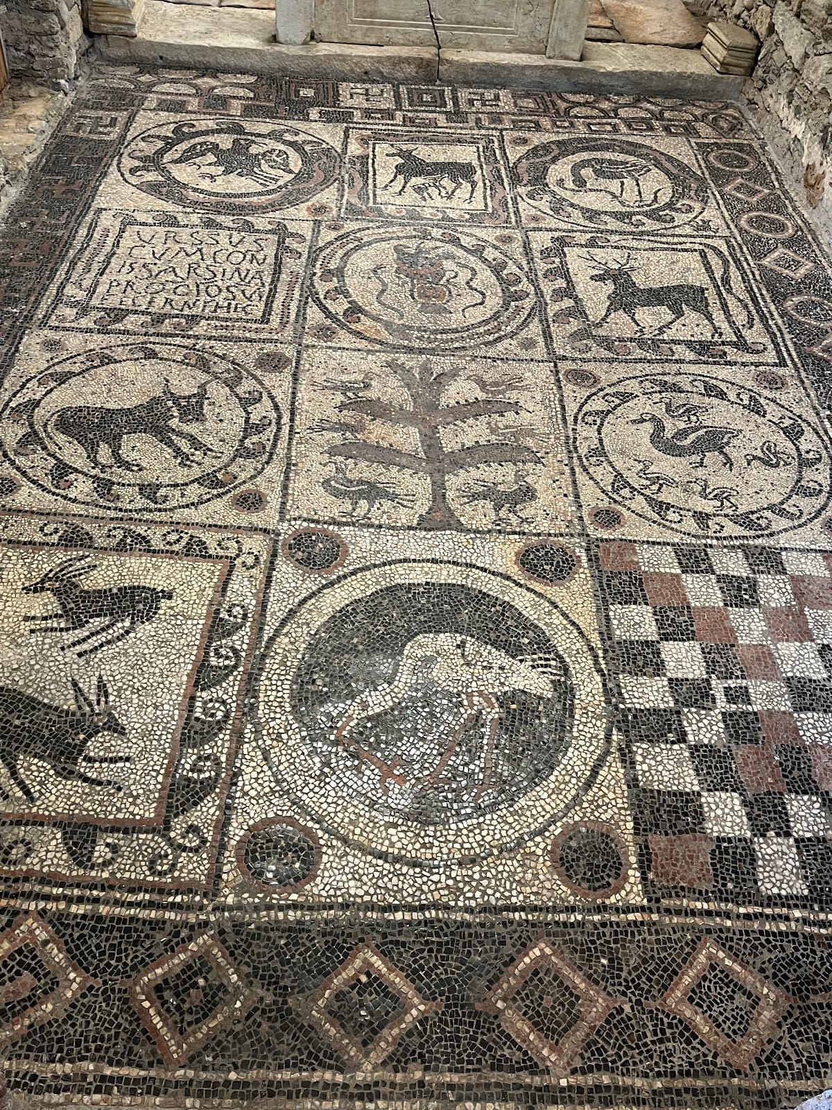
A donor mosaic fills the southern side chapel. It names the governor Ursus and his wife Ursina and contains twelve panels with Christian, mythological, and biblical imagery. The mosaic remains well preserved, and excavations around the church uncovered 65 graves. The church is presented as an open-air museum, with a museum building protecting the mosaic.
Other surviving buildings
Roman town villa
A Roman town villa near the museum originated in the first century AD and was rebuilt around AD 400. Its surviving heating system is a simple hypocaust with a Y-shaped plan.
Parish church
The parish church of St. Peter represents a medieval foundation later rebuilt in Gothic form. Its interior retains frescoes from the fourteenth and fifteenth centuries.