Knidos Ancient City: A Maritime and Cultural Center in Turkey
Table of Contents


Visitor Information
Google Rating: 4.6
Popularity: Medium
Google Maps: View on Google Maps
Official Website: www.kulturportali.gov.tr
Country: Turkey
Civilization: Byzantine, Greek, Roman
Remains: City
Context
Knidos Ancient City is located at the southwestern extremity of the Datça peninsula in Muğla Province, Turkey, positioned on a narrow promontory that separates two natural harbors opening onto the Aegean and Mediterranean seas. The site’s coastal topography features rocky headlands and sheltered bays, providing advantageous anchorages for maritime activities. This strategic location facilitated Knidos’ role as a maritime hub connecting different sea routes in antiquity.
Archaeological evidence demonstrates that the site was occupied from the Archaic Greek period onward, with material culture and architectural remains indicating significant urban development during the Classical and Hellenistic eras. Inscriptions and ceramic assemblages confirm continued habitation and civic activity through the Roman period, while Byzantine-era structures attest to later reuse and religious transformation. The site preserves extensive exposed ruins and stratified deposits across the headland, documented through systematic surveys and excavations conducted by Turkish archaeological teams. These investigations have yielded detailed records of urban planning, inscriptions, and building phases, with many architectural remains visible in situ and artifacts curated in regional museums.
History
Knidos Ancient City evolved over several millennia as a prominent maritime and cultural center at the southwestern edge of Asia Minor. Its location at the confluence of the Aegean and Mediterranean seas shaped its political affiliations, economic pursuits, and urban morphology. The city’s historical trajectory reflects major regional developments, including Greek colonization, Persian imperial expansion, Hellenistic power realignments, Roman provincial administration, and Byzantine ecclesiastical transformations. Although the city was continuously occupied for centuries, its final abandonment in the 7th century CE remains subject to scholarly debate, with evidence suggesting a combination of external raids and seismic disturbances.
Bronze Age and Early Settlement
Archaeological findings indicate intermittent occupation of the Knidos area during the Bronze Age. Material culture includes Minoan and Mycenaean artifacts, suggesting early maritime contacts and cultural interactions across the Aegean. Notably, Linear B tablets from the palace archives at Pylos reference female slaves originating from Knidos, demonstrating some degree of integration into Mycenaean networks around the 12th century BCE. However, continuous settlement during this period is not definitively established, and the extent of early habitation remains limited to scattered finds rather than extensive architectural remains.
Greek Colonization and Archaic Period (7th–6th centuries BCE)
Knidos was established as a Doric Greek colony, traditionally attributed to settlers led by the figure Triopas, though ancient sources differ on whether the founders originated from Sparta or Megara. The city became a member of the Doric Hexapolis, a league of six cities that convened religious and political assemblies at the Apollon Triopios sanctuary located nearby. From the 6th century BCE, Knidos issued its own silver coinage, initially modeled on Milesian standards and later adopting the Aeginetan type, reflecting its economic autonomy and integration into regional trade networks.
During this period, Knidos founded at least three colonies, including Lipara in the Aeolian Islands and Melaina Korkyra in Illyria, indicating its maritime reach. In the mid-6th century BCE, facing the Persian expansion under Harpagos, the city undertook defensive measures by excavating a canal intended to isolate the settlement as an island. Despite this effort, Knidos capitulated to Persian forces in 546 BCE. The city’s territory, known as Knidiē, encompassed the Datça peninsula and adjacent lands, estimated between 200 and 500 square kilometers, underscoring its regional significance.
Classical Period (5th–4th centuries BCE)
In the 5th century BCE, Knidos joined the Athenian-led Delian League, contributing tribute between 452/451 and 425/424 BCE. During the Peloponnesian War, the city shifted allegiance to Sparta in 412 BCE and successfully resisted Athenian attempts to reclaim it, despite lacking substantial fortifications. Between 400 and 300 BCE, Knidos participated in a symmachy (alliance) with Byzantion, Ephesos, and Rhodes, issuing joint coinage marked with the Greek letters ΣΥΜ, reflecting coordinated political and economic cooperation.
The naval Battle of Knidos in 394 BCE was a pivotal engagement in which the Athenian admiral Konon, allied with Persian forces, defeated the Spartan fleet, effectively ending Spartan naval supremacy. Politically, governance oscillated between oligarchic and democratic systems; Aristotle records an oligarchy composed of 60 lifelong magistrates, while by 300 BCE democratic institutions were established, as evidenced by coinage depicting the personification of Democracy. During the 4th century BCE, the city likely relocated from its earlier site near Burgaz to the Tekir promontory at the peninsula’s tip, a move possibly influenced by Mausolus of Caria or Alexander the Great, though scholarly consensus on this relocation remains unsettled.
Hellenistic and Roman Period (3rd century BCE – 6th century CE)
Knidos experienced economic and urban prosperity throughout the Hellenistic and Roman periods. The city became a commercial center specializing in the production and export of olive oil and wine, alongside significant ceramic manufacturing from the 2nd century BCE onward. During the Roman–Syrian War (192–188 BCE), Knidos allied with Rome against Antiochus III, and in 163 BCE, it provided military assistance to the city of Kalynda in a local conflict. Under Roman administration, Knidos was incorporated into the province of Asia and attained the status of a free city (civitas libera), enjoying tax exemptions by the 1st century CE.
The city endured a brief period of pirate control allied with Mithridates VI until Pompey’s campaign in 67 BCE restored Roman authority. Prominent merchant families, such as that of Gaius Julius Theopompus, are documented from this era, illustrating the city’s commercial vitality. Knidos also became an early Christian bishopric in the 4th century CE, reflecting the spread of Christianity in the region. The city’s decline culminated in its abandonment during the 7th century CE, likely due to Saracen raids and possibly compounded by repeated earthquakes.
Byzantine Period
Archaeological evidence attests to continued, albeit diminished, occupation of Knidos during the Byzantine era. Excavations have uncovered early Byzantine churches with mosaic floors, including the so-called Kleopatra basilica and a church constructed atop the former temple of Dionysos, indicating ongoing Christian worship and limited urban activity. The absence of inscriptions from this period suggests a reduction in administrative functions. The city’s decline coincided with regional instability caused by external raids and seismic events, leading to its abandonment by the late 7th century CE.
Daily Life and Importance by Period
Greek Colonization and Archaic Period (7th–6th centuries BCE)
During its foundation as a Doric colony, Knidos developed a structured civic community dominated by Greek settlers, likely organized around aristocratic families who controlled political and religious offices. The Apollon Triopios sanctuary served as a focal point for religious activities within the Doric Hexapolis league. Economic life centered on maritime trade, agriculture—particularly olive and grape cultivation—and artisanal crafts. The city’s issuance of silver coinage and establishment of overseas colonies attest to its active participation in regional commerce.
Defensive efforts, such as the canal dug to isolate the city during the Persian invasion of 546 BCE, demonstrate organized communal labor. Dietary staples included bread, olives, and fish, consistent with coastal Aegean settlements. Transportation relied heavily on maritime vessels utilizing the two natural harbors, facilitating trade and communication. Public religious and civic activities were integral to daily life, supported by sanctuaries and communal buildings.
Classical Period (5th–4th centuries BCE)
Knidos’ population remained predominantly Greek, with social structures balancing oligarchic magistracies and emerging democratic institutions by the late 4th century BCE. Civic officials managed governance alongside popular assemblies. Economic activities intensified, with maritime commerce expanding due to the city’s strategic position between the Aegean and Mediterranean seas. The military harbor’s capacity to accommodate triremes attests to naval capabilities.
Artisans produced pottery and other goods, while agriculture sustained local needs. The urban plan followed the Hippodamian grid system, with the agora serving as a marketplace for both imported and locally produced commodities. Overland transport was limited by rugged terrain, emphasizing seaborne trade. Architectural styles in public and religious buildings included Doric and Ionic orders. Religious life centered on cults of Aphrodite, Apollo Karneios, and Dionysos, with festivals reinforcing communal identity. The city’s naval and cultural prominence was underscored by its role in regional alliances and the decisive naval battle of 394 BCE.
Hellenistic and Roman Period (3rd century BCE – 6th century CE)
During these periods, Knidos’ urban and economic life flourished. The population comprised Greek descendants, Roman citizens, and local inhabitants, with social stratification evident in elite merchant families such as that of Gaius Julius Theopompus. Civic administration adapted to Roman provincial structures, with Knidos attaining free city status and tax privileges.
Economic activities diversified, including olive oil and wine production for local consumption and export, alongside large-scale ceramic manufacturing. Maritime trade thrived via the two harbors, which were protected by breakwaters and fortified with control towers. Urban amenities included baths, cisterns, and public fountains managed by officials like Boulakrates. Residential buildings featured painted walls and stucco decorations reflecting classical architectural motifs. Dietary remains indicate continued reliance on cereals, olives, fish, and wine. Markets within the agora offered a range of goods, including imported luxuries. Transportation combined maritime shipping with limited overland routes. Religious life transitioned to Christianity by the 4th century CE, with pagan temples converted into churches and the establishment of Christian basilicas adorned with mosaic floors. Despite episodes of pirate control and regional conflict, Knidos maintained its commercial and religious significance until its decline in the 7th century.
Byzantine Period
Following the Roman era, Knidos experienced a marked reduction in population and urban complexity, reflecting broader regional instability. The remaining inhabitants practiced Christianity, as evidenced by excavated early Byzantine churches such as the Kleopatra basilica and a church built atop the former Dionysos temple. Social organization likely centered on ecclesiastical leadership and a diminished civic community.
Economic activities contracted, focusing on subsistence rather than extensive trade or production. Archaeological evidence of domestic life is limited, but mosaic floors and reused architectural elements indicate continuity in religious and some residential functions. The city’s harbors and fortifications fell into disuse, and transportation likely relied on small-scale coastal navigation. Knidos’ civic role shifted from a vibrant polis to a minor ecclesiastical center within the Byzantine provincial system. The absence of inscriptions from this period suggests diminished administrative activity. Ultimately, the city was abandoned by the late 7th century, likely due to Saracen raids and seismic events.
Remains
Architectural Features
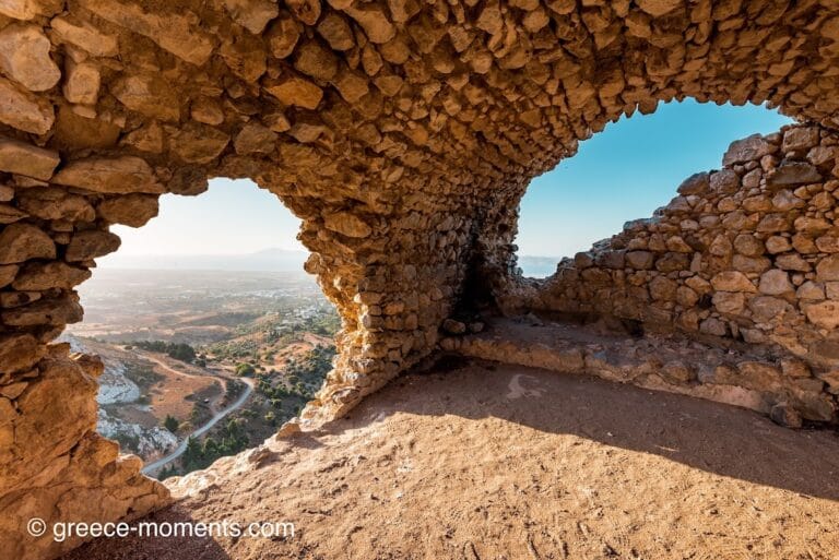
Knidos occupies a narrow headland characterized by two natural harbors separated by a sandy isthmus. The urban layout adheres to the Hippodamian grid plan, with four principal east-west streets intersecting seven north-south streets at right angles. The north-south streets accommodate the sloping terrain through stepped sections. The main agora is situated north of the northern military harbor. Defensive walls approximately 4 kilometers in length enclose the acropolis, lower city, and the Triopion promontory. Sections of these fortifications, including late 5th-century BCE masonry at the Burgaz site, are well preserved. The walls incorporate defensive features such as two tall wave breakers flanking the narrow entrance to the northern military harbor, which could be sealed, possibly by a chain mechanism. Construction materials across the site include limestone, sandstone, and marble, with ashlar masonry typical of Classical and later periods.
The city’s development reflects a transition from the older Burgaz settlement to the Tekir promontory site, indicating urban contraction and relocation during the Classical and Hellenistic eras. The architectural corpus comprises civic, religious, domestic, and military structures, with evidence of continuous occupation and adaptive reuse into the Byzantine period. Several temples were converted into churches during Late Antiquity. The site preserves both well-preserved and fragmentary remains, many visible in situ and others documented through excavation and surface survey.
Key Buildings and Structures
City Walls
The city walls extend approximately 4 kilometers, enclosing the acropolis, lower city, and the Triopion promontory. The Burgaz site features late 5th-century BCE fortifications, possibly enclosing the acropolis. The walls are constructed primarily of ashlar masonry with bossed limestone blocks, characteristic of Classical Greek defensive architecture. Defensive elements include two high wave breakers flanking the narrow entrance to the northern military harbor, which could be closed, likely by a chain. The walls encompass both the military and commercial harbors, indicating a comprehensive defensive perimeter.
Afrodite Euploia Temple
Located on a northwest slope of the city, this 4th-century BCE temple is dedicated to Afrodite Euploia, the city’s patron goddess associated with safe sea passage. The temple is an open circular (monopteros) structure in Doric style, surrounded by 18 columns, with Corinthian elements possibly present in interior columns or later modifications. Constructed from limestone, sandstone, and marble, it housed the renowned marble statue of Aphrodite of Knidos by Praxiteles, depicting the goddess nude. The statue was placed within a cella featuring doors on both front and back, allowing viewing from multiple angles. The altar lies east of the temple, accessible via stairs leading to the temple base. The temple underwent restoration during its history. The statue remained until it was transferred to Constantinople and destroyed in a fire. The temple ruins were rediscovered in 1969.
Apollon Karneios Temple
This Doric temple is situated south and lower on the slope from the Afrodite Euploia temple. Dating partly to the 2nd century BCE, it measures approximately 19 by 11 meters and is associated with the Doric Hexapolis games ceremonies. Access was provided by a monumental Ionic propylon (gateway) dated to around 300 BCE. The temple’s remains include foundation walls and architectural fragments confirming its Doric order. An Early Byzantine church was later constructed on or near this site, reusing temple materials.
Dionysos Temple
Located north of the isthmus between the two harbors, the Dionysos temple was built in Ionic style and likely had a peripteral layout. Fragments of a frieze depicting Dionysian scenes identify the temple’s dedication. The temple’s stones were repurposed in the early Byzantine period for a church constructed on the same site. The remains include foundation walls and sculptural fragments.
Demeter Sanctuary
Situated on a terrace at the eastern end of the city, the Demeter sanctuary yielded a marble cult statue of seated Demeter dating to circa 350–330 BCE, now housed in the British Museum. The sanctuary’s architectural remains include a terrace and foundation elements consistent with a cultic precinct.
Other Temples
North of the Dionysos temple stands a small tetrastyle prostyle temple in Corinthian style, constructed during the Roman period under Emperor Hadrian. The city also contained temples dedicated to Afrodite Akraia and Afrodite Doritis, though their remains are less well preserved. Inscriptions attest to a cult of the Dioscuri, suggesting the presence of a sanctuary or shrine associated with these deities.
Stoa
A long Doric-style stoa extends between the Dionysos temple and the Corinthian temple. Constructed in two phases, the earliest dates to the 4th century BCE. The stoa measures approximately 132 meters in length and 13 meters in width. Its exterior was fully clad in marble, including colored opus sectile panels with vegetal and geometric motifs. White-blue marble panels with letter-shaped reserves were found on the exterior. Corinthian capitals and columns, some showing fire damage, were uncovered. Excavations revealed a marble-paved room with benches, a podium, and a statue base dedicated to Zeus by Teandros son of Similos. Inscriptions mention prominent local families and Emperor Hadrian (Antoninus Pius). Bronze and ceramic oil lamps, coins, and numerous marble statues were also found.
Theatres
Knidos had two Greek theatres. The smaller theatre, located east of the Dionysos temple near the northern shore of the commercial harbor, was originally built in the Hellenistic period. It was renovated and expanded in the Roman period, including the addition of a skene (stage building). This theatre’s seating area remains partially preserved and could accommodate approximately 5,000 spectators. The larger theatre, situated on the southwestern slope of the acropolis, had a capacity of about 20,000. Almost no remains survive of this larger theatre, as its stones and marble were removed in the 19th century.
Harbors
The city’s two harbors are separated by the isthmus connecting the island (Triopion) to the mainland. The northern smaller harbor served as a military harbor, accommodating up to 20 triremes. Its narrow entrance is flanked by two high wave breakers and could be closed, possibly by a chain. The southern harbor was larger and functioned as the commercial harbor, protected by two longer wave breakers. The southern wave breaker remains visible today, while the northern one is mostly submerged but detectable in satellite imagery. Remains of harbor structures, including wave breakers and quays, are preserved.
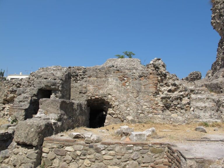
Early Byzantine Churches
Five early Byzantine basilica churches dating to the 4th–5th centuries CE have been excavated within the city. One, known as Church C, was built on the site of the Dionysos temple, reusing temple stones. Church C preserves a mosaic floor decorated with geometric patterns. Another basilica, called the Cleopatra Basilica, also retains surviving floor mosaics. These churches reflect the Christian phase of urban occupation and reuse of earlier religious structures.
Buleuterion (Council Building)
A covered building in the southeastern part of the city, formerly identified as an odeion (small theatre or concert hall), is now considered a buleuterion (council meeting place). The structure’s architectural features include a roofed hall suitable for assemblies. Its construction date is not precisely established but corresponds to the Hellenistic or Roman periods.
Domestic Buildings
Remains of Hellenistic and Roman period houses have been uncovered, including wall paintings and stucco decorations imitating Doric, Ionic, and Corinthian architectural styles. These domestic structures are located primarily on the island part of the city (Cape Krio) and along Harbor Street. Excavations revealed terraced rows of shops, workshops, and dwellings dating from the 4th century BCE to the 5th century CE.
Stadium
A stadium existed outside the city walls, though only limited remains have been documented. Its precise location and extent remain partially unclear.
Heroon on Harbor Street (Mekan 4)
Located along Harbor Street, this building was originally a modest rectangular shop or workshop from the Late Classical–Early Hellenistic period. In the Roman Imperial period, it was transformed into a grand Heroon with a Corinthian distyle in antis façade, including two pilasters and two Corinthian columns with marble architraves, friezes, and cornices dated to the Severan period. Later in Late Antiquity, the façade was partly walled up, and the building was converted back into shops or workshops with plan modifications. The entrance features a 1.55-meter-wide marble threshold and a 1.60-meter-wide doorway framed by the original Heroon columns. A terracotta water pipe runs outside along Harbor Street. The marble floor and seating were mostly dismantled, with only small fragments surviving.
Other Harbor Street Buildings (Mekan 1–7)
Seven adjacent rectangular rooms or shops align along Harbor Street, facing west toward the street. Floors step up about 0.5 meters from south to north, matching the street’s slope. Walls are built in isodomic masonry with bossed limestone blocks typical of 4th-century BCE construction. Rear and side walls were built with mortar and plastered; interior walls were later modified in Roman or Late Antique periods. These buildings originally functioned as a row of shops and were later altered in plan and use.
Doric Temple with Early Christian Church (Corinthian Temple)
On a terrace west of the road leading to the Apollon temple, a Doric temple with a 6×13 column peripteral plan measuring 23.00 by 13.50 meters was found. Built of gray-pink limestone, it is known as the “Pink Temple.” Architrave and triglyph-metope fragments confirm its Doric order. An inscription on a statue base from the Early Roman Imperial period suggests dedication to Apollo Karneios. An Early Byzantine church was constructed on the temple’s remains, likely reusing temple materials.
Propylon
A monumental Ionic propylon (gateway) stood between the round temple terrace and the Apollon terrace. Some fallen column drums and foundations survive, indicating its original location and scale. The propylon dates to around 300 BCE.
Main East-West Street and Drainage
A broad east-west street was partially excavated in 1995–1996. Beneath it, a sophisticated drainage system was uncovered, demonstrating advanced urban infrastructure. The street forms part of the Hippodamian grid plan and connects major city sectors.
“Pink Temple”
Located south of the Apollon terrace, only foundation remains survive of this temple constructed of pink local stone. It was later converted into a church during the Byzantine period.
Dionysos Terrace and Temple
West of the large harbor and north of the small theater, the Dionysos terrace contains the remains of the Dionysos temple, later converted into a church. The site includes foundation walls and reused architectural elements.
Fountain Structure
Excavated south of Harbor Street, the fountain consists of a square podium with vertical balustrade blocks forming a basin. The upper part is cylindrical with architraves featuring water spouts. An inscription states the fountain was built and dedicated to the public by Boulakrates, head of the city waterworks.
Other Island Part (Cape Krio)
Excavations on the island part of the city (Cape Krio) revealed terraced rows of shops, workshops, and dwellings. Occupation here dates from the 4th century BCE to the 5th century CE. The area includes domestic and economic structures aligned with the city’s grid plan.
Necropolis
The necropolis extends east of the city, from the city walls up to 10 kilometers away. Numerous sarcophagi and various tomb types have been found, including rock-cut tombs and funerary buildings. One funerary enclosure (temenos) measures about 37 meters on each side, surrounded by a fence and containing two or three small tomb buildings.
Burgaz Site (Older City Location)
At the presumed older city site near Burgaz, remains of walls dating to the late 5th century BCE have been found, possibly enclosing the acropolis. Building and paved street remains from the Archaic and Classical periods have been uncovered. Harbor wave breaker remains dating to the 4th century BCE are present. Ceramic finds indicate habitation at least from the 7th century BCE.
Apollon Triopios Sanctuary (Triopion)
Located about 15 kilometers east of Burgaz, outside the city, this sanctuary served as the meeting place of the Doric Hexapolis league. Excavations revealed a small Hellenistic temple and traces of an older, larger temple. The site includes foundation remains and architectural fragments.
Observatory and Medical School
Ancient sources, notably Strabo, mention an observatory built by the astronomer Eudoxus in Knidos, used for star observations such as the star Canopus. The observatory was reportedly not taller than surrounding buildings. Neither the observatory nor the medical school, renowned in antiquity and second only to that of Kos, has been located archaeologically. The medical school was known for emphasizing the art of medicine over natural healing, with notable physicians including Euryphon and Chrysippos.
Other Remains
Surface traces of buildings, paved streets, and harbor structures are visible across the site. Some buildings are poorly preserved or only partially excavated, including domestic quarters, workshops, and minor religious structures. The city plan, including streets, walls, and major buildings, has been documented through excavation and surface survey.
Preservation and Current Status
The ruins of Knidos include well-preserved city walls, temple foundations, and the smaller theatre, which retains significant structural elements. The larger theatre survives only in fragmentary form due to 19th-century stone removal. Temples such as the Afrodite Euploia and Apollon Karneios temples have visible remains, though some are partial. Early Byzantine churches preserve mosaic floors and reused architectural materials. Many domestic buildings and commercial structures survive as foundations or partial walls.
Restoration efforts have been limited, with some stabilization of structures but no extensive modern reconstruction. Excavations have been ongoing since the late 20th century, led by Turkish archaeological teams. Artifacts recovered are housed in regional museums in İzmir and Bodrum. Environmental and human threats to the site are not detailed in the available sources.
Unexcavated Areas
Several parts of Knidos remain unexcavated or only partially studied. The exact locations of the observatory and medical school mentioned by ancient sources have not been identified archaeologically. Some domestic and commercial quarters, as well as sections of the necropolis extending up to 10 kilometers east of the city, await further investigation. Surface surveys and geophysical studies have indicated buried remains in various sectors, but detailed excavation plans or limitations due to conservation policies are not specified in the sources.
Nearby sites