Burg Liebau: A Medieval Castle in Pöhl, Germany


Visitor Information
Google Rating: 4.4
Popularity: Low
Google Maps: View on Google Maps
Official Website: www.vogtland.de
Country: Germany
Civilization: Unclassified
Remains: Military
History
Burg Liebau is a medieval castle site located in the municipality of Pöhl, Germany. It was originally established by the regional powers of the Middle Ages, serving as a fortified stronghold in the Elster valley area.
The earliest written record of the castle dates back to 1327, when it was called “castrum lubawe.” This name reflects the site’s medieval origins as a defensive and administrative center. During the 14th century, the castle was owned by Heinrich the Elder, a Vogt (a title roughly equivalent to governor or bailiff) from Plauen. He transferred Burg Liebau to the Wettin family, an important noble dynasty, in an exchange that highlights the castle’s value within regional power networks.
By the middle of the 15th century, ownership had passed to the Doelau family, who began transforming the fortress. Between 1500 and 1550, they renewed the site, turning it from a primarily military installation into a Renaissance-style manor house. This change illustrates a broader trend of shifting castle functions from defense to residential and representative purposes during that era.
During the Thirty Years’ War, a destructive conflict that ravaged much of Central Europe, the castle suffered significant damage. In 1640, Swedish mercenaries plundered and set parts of the castle on fire, with the stair tower particularly affected. Despite this setback, the Doelau family maintained possession of Burg Liebau until 1725. Following this, the estate passed briefly to Johanna Charlotte von Beust, who owned it until 1742. After her tenure, the castle was abandoned and gradually fell into ruin.
Beginning in the late 20th century, preservation and archaeological work was undertaken between 1995 and 1997 in collaboration with the Saxon State Office for Archaeology. These efforts recognized Burg Liebau’s historical significance and helped protect the site as a cultural monument in the region.
Remains
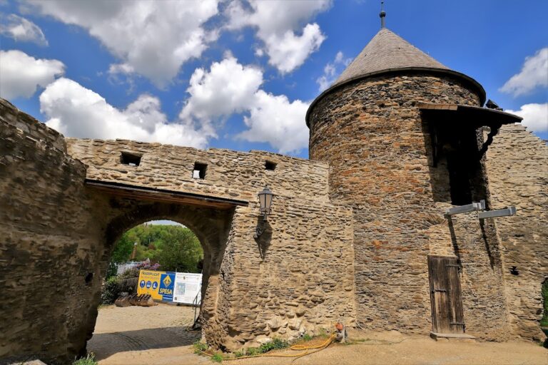
The castle stands on a roughly triangular plateau of about 50 by 30 meters, perched on a flat rock spur overlooking the right bank of the Elster valley. The placement on a natural elevation provided strategic advantages and made use of the surrounding terrain for defense.
At the heart of the site lie the ruins of the core castle complex, which extend approximately 20 to 25 meters across. Archaeological evidence suggests that this central area contained several key structures including a combined defensive and residential tower, a gate tower controlling access, and a curtain wall encircling the complex. The curtain wall featured a battlement walk, a walkway along the top used by defenders.
Defensive enhancements were notable. On the more vulnerable sides of the plateau, two deep ditches were cut directly into the rock, each about five meters wide and two meters deep. To the east, the site is further protected by a neck ditch—a defensive trench that is 20 to 25 meters wide and five to six meters deep. This was crossed by a drawbridge, a typical medieval method of controlling entry to a fortification while adding an extra layer of security.
Construction primarily used local stone, allowing the castle to blend with its rocky foundation and adapt to the natural landscape. Today, the site remains as a ruin with visible sections of walls and defensive ditches intact, revealing the scale and sophistication of the fortress’s design.
Burg Liebau occupies a position within a regional chain of fortifications, lying about two kilometers north of the Pöhl reservoir and roughly four to five kilometers north of the Elsterberg castle ruins situated on the opposite bank of the Elster River. This proximity suggests a network of castles worked together to oversee and protect the surrounding territory.
Nearby sites