Apameia: An Ancient City in Syria with Rich Historical and Archaeological Heritage


Visitor Information
Google Rating: 4.4
Popularity: Very Low
Google Maps: View on Google Maps
Official Website: asili.yoo7.com
Country: Syria
Civilization: Byzantine, Early Islamic, Greek, Medieval Islamic, Roman
Remains: City

History
Apameia is located in the modern Hama Governorate of Syria, near the town of Qalaat Al Madiq. The city was originally established as a Macedonian military camp around 320 BCE, shortly after the Triparadeisos treaty. This foundation likely involved the generals Antipater and Cassander. Around 300 BCE, Seleucus I Nicator, founder of the Seleucid Empire, refounded the settlement as a polis and renamed it Apameia in honor of his Bactrian wife, Apama.
During the Seleucid period, Apameia became a key military and economic center in northern Syria. Its strategic position on the Orontes River, surrounded by a lake and marshes, created a natural peninsula. The city was one of the four that formed the Syrian Tetrapolis. It hosted a large Seleucid military presence, including 500 war elephants and a horse breeding facility with tens of thousands of mares and hundreds of stallions. Apameia also served as a minting site for Seleucid coinage.
In the 1st century BCE, the city suffered destruction at the hands of Pompey. Under Roman rule, it was refounded as Claudia Apamea. The city resisted Julius Caesar’s forces during the Syrian revolt until 46 BCE.
The city endured a major earthquake in 115 CE but was quickly rebuilt. From 218 to 234 CE, Apameia served as the winter base for the Roman Parthian legion II.
By the early 5th century, Apameia became the capital of the province Syria Secunda. It was also home to a well-known philosophical school. The city faced destruction again in 540 CE when the Sasanian king Khosrow I attacked. It later fell under Sasanian control during the Byzantine–Sasanian War between 602 and 628 CE.
Following the Muslim conquest in the 7th century, Apameia was partially restored and used as a military observation post. Control of the city passed through various Muslim dynasties. In the late 11th and early 12th centuries, Crusaders briefly held the city. The site suffered damage from an earthquake in 1152 CE. In modern times, the city experienced extensive looting and damage during the Syrian civil war.
Archaeological excavations began in 1928 under Belgian leadership and continued intermittently until recent conflicts halted work. Many important artifacts from Apameia are preserved in the Art and History Museum in Brussels.
Remains
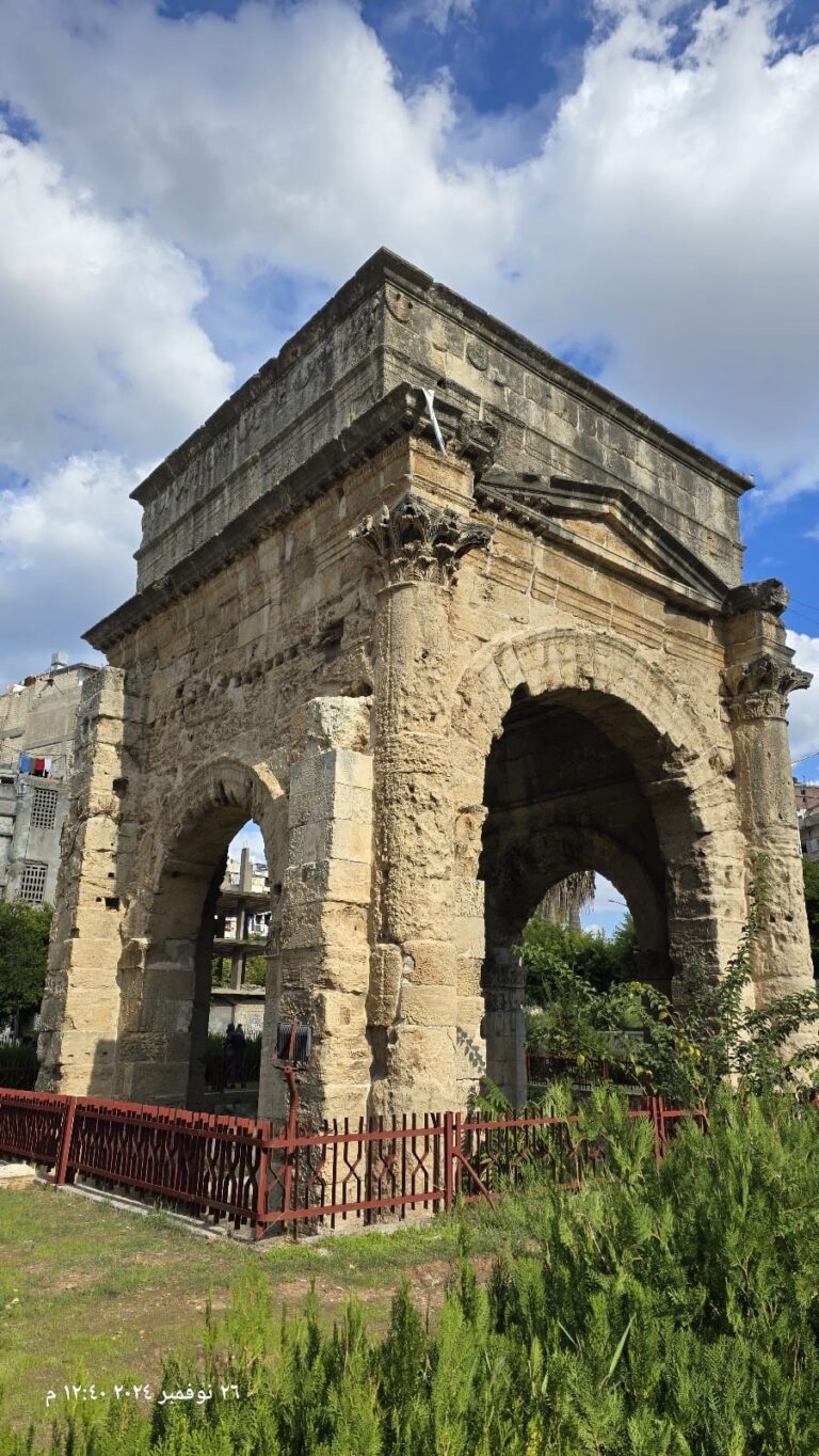
Apameia’s ancient city covered about 2,600 dunams within walls approximately 7 kilometers long. The urban layout followed a grid plan, divided by the Great Colonnade running north-south and a theater street crossing east-west. The main street was paved with mosaics and intersected by three streets leading to the city walls. An advanced drainage system served the street network.
The Great Colonnade is one of the longest in the Roman world, stretching nearly two kilometers along the city’s main boulevard, or cardo maximus. Originally built during the Seleucid era, it was destroyed by the 115 CE earthquake and rebuilt in the 2nd century CE. The colonnade is about 6 meters wide, with columns standing 9 meters tall on square bases. Two column styles exist: plain columns from Emperor Trajan’s reign and spiral-fluted ones from Antoninus Pius’s time. The colonnade was lined with public buildings such as baths, an agora, the temple of Tyche, a nymphaeum (a monument dedicated to water nymphs), a rotunda, an atrium church, and a basilica. Mosaics decorated the porticoes along its length. Under Emperor Justinian I, parts of the colonnade were restored, the street narrowed to 12 meters by adding pedestrian walkways, and a monumental four-column portico was constructed.
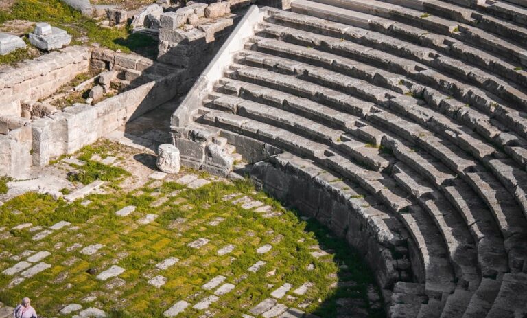
The Roman theater, built on a steep hill overlooking the Orontes valley, is among the largest surviving Roman theaters. Its diameter measures approximately 139 meters, with an estimated seating capacity exceeding 20,000. Originally Hellenistic, it was expanded during the early Roman period. The 115 CE earthquake severely damaged the theater, which was restored under Trajan and Hadrian and further enlarged in the early 3rd century CE. In Byzantine times, a qanat (an underground water channel) was built beneath the lower stage, ending the theater’s use for performances but maintaining its role as a water source. Only about one-eighth of the theater has been excavated, with much of its stone later quarried for a nearby fortress.
A large hunting mosaic, covering 120 square meters and dating to 415–420 CE, was originally part of the reception hall in the Roman provincial governor’s palace. This mosaic is now housed in Brussels and is considered one of the finest of its kind, comparable to mosaics found in Constantinople’s imperial palace.
Near the city center, a 4th-century Jewish synagogue featured a geometric mosaic floor with 19 inscriptions naming donors and officials. This synagogue was converted into a Christian church in the 5th century.
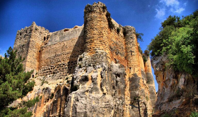
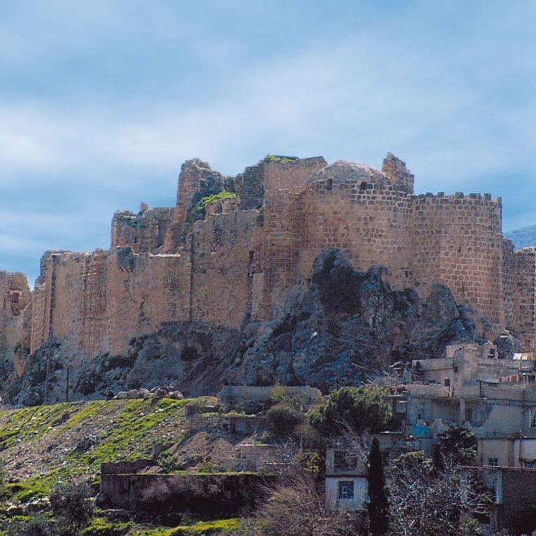
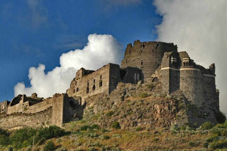
The ancient acropolis area contains remains of richly decorated temples mentioned by the historian Sozomen. The city’s fortifications, known as Qalaat al-Mudik, form a polygonal fortress with high walls and square towers. Built mainly in the 12th century by Muslim rulers after the 1152 earthquake, the fortress sits on a high artificial mound west of the city, surrounded by fertile plains. It includes a large gate with a vaulted arch and flanking guard towers. Much of the fortress walls remain intact, though some sections have collapsed.
The site has suffered extensive damage and looting during recent conflicts. Satellite images reveal hundreds of illicit excavation pits scattered across the area. Despite this, many significant archaeological features remain visible in situ or preserved in museums.