Rudelsburg Castle: A Medieval Hill Castle in Saxony-Anhalt, Germany


Visitor Information
Google Rating: 4.7
Popularity: Medium
Official Website: www.rudelsburg.info
Country: Germany
Civilization: Medieval European, Modern
Site type: Military
Remains: Castle
History
The Rudelsburg is a medieval hill castle located above Saaleck in Saxony-Anhalt, Germany. It was first recorded in 1171 as property of the Naumburg ministeriales, a class of unfree knights serving the bishops. The castle was likely founded by the Bishops of Naumburg during the High Middle Ages to protect important trade routes, including the Via Regia and the Saale River bridge at Bad Kösen.
In 1238, the castle was granted as a fief to the Margraves of Meissen from the House of Wettin. The Wettin family ruled the area through their ministeriales, leading to ongoing conflicts with the bishops over control of the castle and surrounding lands. This rivalry shaped much of the castle’s medieval history.
In 1348, the citizens of Naumburg besieged the Rudelsburg under Johann von Trautzschen. During this attack, the outer ward was destroyed, possibly marking one of the earliest uses of firearms in Germany. The inner ward survived the siege but suffered damage. The castle continued to serve as a noble residence for various families, including the Schenken von Saaleck in 1383 and the von Bünau brothers in 1441.
The castle faced further destruction in 1450 during the Saxon Brother War, when it was besieged and damaged again. In 1640, Swedish troops burned the Rudelsburg during the Thirty Years’ War. The castle was abandoned the following year and fell into ruin.
In the 18th century, the outer ward was quarried extensively for building stone, nearly erasing it. A work accident in 1770 stopped further demolition, preserving the inner ward ruins. The von Schönberg family acquired the castle in 1797 and maintained ownership until 1945, establishing a family trust.
During the 19th century, the Rudelsburg became a popular romantic destination and a meeting place for student fraternities, especially the Kösener Senioren-Convents-Verband (KSCV) from 1855. Restoration efforts began in the 1870s under royal building officer Oskar Mothes, who repaired walls, the knight’s hall, and the entrance. Several monuments commemorating fallen fraternity members from various wars were erected between 1872 and 1926.
The castle remained a student fraternity venue until 1934. After World War II, it came under East German control and was neglected. Some metal parts were melted down during this period. From the 1960s, student traditions were secretly revived, with official meetings resuming in 1987. Since German reunification, the Rudelsburg has been restored and preserved as a historic site.
Remains
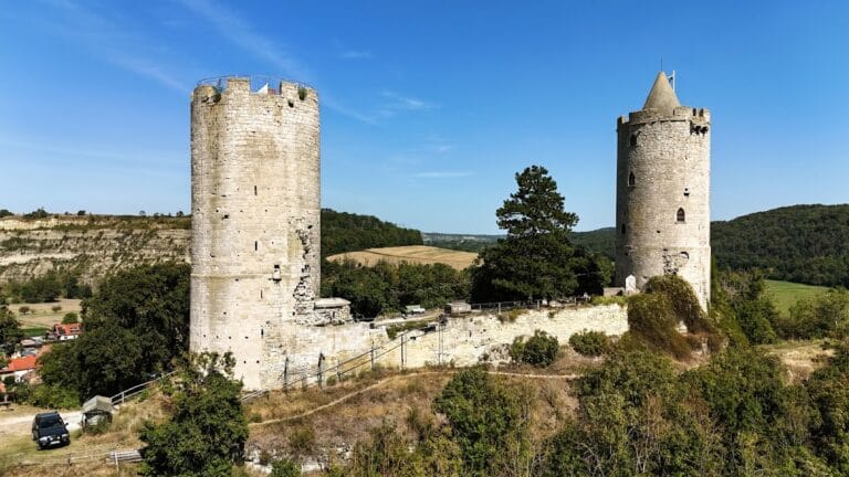
The Rudelsburg sits on a rocky Muschelkalk limestone ridge about 85 meters above the Saale River. The castle is oriented roughly west-southwest to east-northeast and features steep slopes, especially toward the river. It consists of a large outer ward and a smaller inner ward.
The outer ward, or Vorburg, covers approximately 22,000 square meters, unusually large for a hill castle. It lies on a higher plateau and once contained residences for the castellans (castle officials) and production buildings. Its ring walls, ditches, and two gates enclosed stone and half-timbered structures close to the walls. Most of the outer ward’s walls survive only in the south and east, as much was dismantled in the 18th century for building stone.
The inner ward, or Kernburg, is separated from the outer ward by a deep neck ditch. It forms an irregular quadrangle about 40 by 24 meters around a small courtyard. A prominent Romanesque bergfried, or keep, stands about 20 meters high in the southeast corner. This tower has an almost square base measuring 7.6 by 8.2 meters and is topped by a distinctive stone pyramid-shaped roof, giving the castle its characteristic silhouette. The bergfried’s basement now contains a modern dungeon.
On the west side of the inner ward is a rectangular palas, or great hall, dating to around 1200. It features Romanesque capitals and faces a steep cliff over the Saale River, making it the least vulnerable side to attack. The northern ring wall is set back about 1.5 meters from the cliff edge to prevent collapse due to fragile limestone. This led to the later addition of a bastion-like corner tower on the northeast.
The eastern side includes a zwinger, an outer ward between inner and outer walls, likely built in Romanesque times. It was reinforced in the 15th century with bastion walls and round corner towers forming a defensive ring. Archaeological excavations in the 19th and early 21st centuries uncovered remains of walls and buildings in the outer ward, as well as prehistoric settlement layers beneath medieval deposits. Finds include pottery shards and a Bronze Age garment pin, indicating long-term occupation of the site.
Several monuments erected by student fraternities stand in the outer ward area. These include the 1872 Kösener Gefallenendenkmal (Pillar to the Fallen), the 1890 Kaiser Wilhelm I Obelisk, the 1896 Young Bismarck Monument (rebuilt in 2006), and the 1926 Löwendenkmal (Lion Monument). These memorials were restored after damage during the East German period.
Today, the inner ward remains as a ruin with sections restored in the 19th century. The bergfried and palas are the most prominent surviving structures. The outer ward is mostly lost, with only fragments of walls remaining. The site preserves a layered history visible in its medieval architecture and archaeological remains.
Nearby sites