Site Archéologique de Cherré: A Gallo-Roman Religious and Commercial Complex in Northwestern France
Table of Contents
Visitor Information
Google Rating: 4.3
Popularity: Very Low
Google Maps: View on Google Maps
Official Website: fr.wikipedia.org
Country: France
Civilization: Celtic, Roman
Remains: Religious
Context
The Site Archéologique de Cherré is situated near Aubigné-Racan in the Sarthe department within the Pays de la Loire region of northwestern France. It occupies a gently inclined plateau overlooking the valley of the Loir River, a tributary of the Loire. The surrounding environment comprises a mosaic of woodland and cultivated fields, reflecting a rural landscape that has persisted since antiquity. The site’s location commands local communication routes linking the Loire basin to the interior of the Maine region, positioning it strategically for controlling movement and exchange in this part of Gaul.
Cherré’s archaeological record demonstrates primary occupation phases during the late Iron Age and the Roman Imperial period. Initially established as a Gallic funerary and ritual center, it later developed into a Gallo-Roman complex with religious, commercial, and social functions from the 1st century CE onward. The site’s topography and proximity to natural resources, including water from the Fontaine de Chenon spring, influenced its layout and infrastructure. Preservation has benefited from limited modern urbanization, allowing extensive archaeological investigation and conservation under regional heritage management.
History
The historical trajectory of the Site Archéologique de Cherré reflects significant cultural and political transformations in northwestern Gaul from the late Bronze Age through the early medieval period. Initially serving as a funerary and cultic landscape during the protohistoric era, the site evolved into a prominent Gallo-Roman religious and commercial center in the early Imperial period. Its development and eventual decline correspond with broader shifts in the Roman province of Gallia Lugdunensis, including changes in religious practices and economic organization. After abandonment in late antiquity, the site experienced limited reuse during the early Middle Ages before falling into obscurity until its modern archaeological rediscovery.
Protohistoric Period: Late Bronze Age to Iron Age (Hallstatt and La Tène Periods)
During the late Bronze Age and early Iron Age, the Cherré area functioned primarily as a necropolis, situated at the confluence of three Gallic tribal territories: the Andécaves, Aulerques Cénomans, and Turons. Archaeological excavations have uncovered megalithic monuments, tumuli, and individual graves characterized by cremation rites. Notably, some burials contained rare grave goods such as glass beads, indicating selective funerary practices. This necropolis was likely associated with the nearby fortified promontory known as the “camp de Vaux,” occupied from the 7th century BCE and protected by a palisade-supported rampart, suggesting a complex social and defensive landscape.
Ritual deposits of weapons dating from the La Tène B2 to D phases (circa 3rd century BCE) were discovered in a marshy area adjacent to the later Roman temple precinct. These offerings comprised 73 metal objects, including swords, scabbards, axes (notably “currency-bar” types), lances, and cauldron fragments, often accompanied by animal skulls—primarily suids and bovids—and pottery shards. Such assemblages attest to the site’s role in religious and warrior cult activities during the Iron Age. Surrounding the necropolis, several enclosures of varying shapes and sizes have been identified, possibly linked to funerary or ritual functions, although their precise dating remains uncertain due to the absence of associated artifacts.
Roman Conquest and Early Imperial Period (Late 1st century BCE – 3rd century CE)
Following the Roman conquest of Gaul in the 1st century BCE, the territory encompassing Cherré was incorporated into the province of Gallia Lugdunensis. The site underwent a significant transformation from a funerary landscape into a monumental Gallo-Roman complex during the late 1st century CE. It developed as a vicus—a secondary settlement—strategically located near Roman roads connecting Caesarodunum (Tours), Vindunum (Le Mans), and Poitiers, and benefiting from the navigability of the Loir River for transport and communication.
The monumental phase saw the construction of a semicircular theater with an estimated capacity of approximately 3,000 spectators. This theater was deliberately erected over earlier protohistoric tumuli and megaliths, symbolically linking Roman presence with the indigenous past. Adjacent to the theater, a large hall initially functioned as a covered market and was later expanded into an open courtyard surrounded by double colonnaded galleries. Archaeological evidence, including extensive deposits of butchered animal bones (predominantly cattle), oyster shells, pottery shards, and over 540 coins, indicates this building served as a commercial and butchery center.
Religious architecture was prominent, with the main temple constructed under Emperor Domitian (81–96 CE) and enlarged in the mid-2nd century CE. The temple’s rectangular plan, featuring a square cella surrounded by a gallery and enclosed within a 90-meter square peribolos wall with eight exedrae niches, reflects a celto-Roman architectural synthesis influenced by imperial cult sites such as the Maison Carrée in Nîmes. Its orientation aligns with the sunrise on the Roman Vinalia festival dates (April 23 and August 19), suggesting cultic significance potentially related to the imperial cult or a martial deity. Decorative elements include opus spicatum masonry patterns, pilasters, multicolored frescoes, and stucco motifs. The discovery of a fragment of a Victory statue supports the interpretation of an imperial or warrior cult dedication.
The thermal baths, constructed in the late 1st century and expanded in the early 2nd century, covered approximately 926 square meters. The complex comprised a palaestra, frigidarium with cold pool, caldarium with hot pool, and a hypocaust heating system. The modest size of bathing rooms suggests restricted access, likely reserved for temple personnel rather than the general populace. Water was supplied by a 4.5-kilometer underground aqueduct sourced primarily from the Fontaine de Chenon spring, with wooden and lead pipes distributing water to the forum, baths, and temple. Integrated drainage systems and latrines directed wastewater toward the Loir River. Despite the presence of roads and paved areas, no evidence of permanent residential housing or a formal street grid has been identified, indicating the site functioned chiefly as a religious, commercial, and seasonal gathering place rather than a permanent urban settlement.
Late Roman Period and Decline (Late 3rd – Early 4th century CE)
During the late 3rd century CE, Cherré experienced a marked decline in occupation, reflecting broader regional instability within Gallia Lugdunensis amid economic difficulties, political crises, and increased insecurity across the Roman Empire. The thermal baths were abandoned by the end of the 2nd or early 3rd century, preceding the overall decline of the complex. The rise of Christianity and the concomitant waning of traditional imperial and warrior cults likely contributed to the site’s reduced religious and social significance. Archaeological evidence indicates cessation of major activity by the early 4th century, although no specific historical events or environmental factors have been definitively linked to the abandonment.
Early Medieval Period (Merovingian and Carolingian Eras)
Following the Roman period, the site was largely deserted but saw limited reuse as a burial ground during the early Middle Ages. Excavations have revealed a small necropolis of 39 graves near the former temple precinct, probably dating to the Merovingian or Carolingian periods. These burials consist of simple inhumations in earth pits and schist coffins. Another nearby necropolis, documented through 19th and 20th-century reports and a clandestine 1975 excavation, contained 34 sandstone sarcophagi. The presence of a possible small Christian sanctuary associated with these burials indicates a religious transition from earlier pagan practices to Christian worship.
During this period, the site’s monumental stones were extensively quarried and repurposed in local Romanesque churches in nearby villages such as Aubigné-Racan, Coulongé, Vaas, and Verneil-le-Chétif, as well as in the former abbey church of Notre-Dame de Vaas. The land reverted to agricultural use, limiting the accumulation of archaeological deposits and leaving the ruins near surface level by the time of their modern rediscovery.
Modern Rediscovery and Archaeological Research (18th century to Present)
The ruins of Cherré have been known since at least the early 18th century, traditionally identified as the “castle of Gane” in local legend. Early 19th-century descriptions recognized the remains of a Roman theater. Initial excavations commenced in 1875 under Gustave de Cougny and the vicomtesse de Quatrebarbes, producing partial plans and descriptions of the theater, temple, baths, and market-forum. However, these early investigations were limited and sometimes damaging due to lime kiln construction and stone reuse.
Systematic archaeological research began in 1976 under state direction, continuing until 2006. These excavations uncovered the protohistoric necropolis, theater, forum, temples, baths, and aqueduct, revealing complex stratigraphy and architectural phases. The site was designated a protected natural area in 1975, with the theater listed as a historic monument in 1982 and the remainder of the remains protected in 1991. Since the 2000s, the Sarthe departmental council has managed the site, implementing visitor facilities, educational programs, and conservation measures. Cherré is recognized as one of the most extensively studied secondary urban complexes in western Gaul, contributing significantly to understanding regional Gallo-Roman settlement patterns. The site also forms part of a Natura 2000 protected area, underscoring its combined cultural and environmental importance.
Daily Life and Importance by Period
Roman Conquest and Early Imperial Period (Late 1st century BCE – 3rd century CE)
During its Gallo-Roman phase, Cherré functioned primarily as a vicus focused on religious, commercial, and seasonal activities rather than permanent habitation. The population likely comprised a mixture of indigenous Gallic inhabitants and Roman settlers, including temple personnel, merchants, artisans, and itinerant visitors attending festivals or markets. While direct evidence of social organization is limited, gender roles probably conformed to Roman provincial norms, with men occupying civic, religious, and commercial roles and women managing domestic spheres.
Economic life centered on religious service and commerce. The monumental temple complex, baths, and market hall indicate specialized occupations such as priests, bath attendants, butchers, and traders. The large quantities of animal bones—predominantly cattle—and oyster shells found in the market area suggest active butchery and consumption of both local and imported foodstuffs. Production activities appear to have been workshop-scale, with no evidence for large-scale manufacturing. The aqueduct and baths imply the presence of skilled hydraulic and construction workers responsible for infrastructure maintenance.
The diet included bread, cereals, meat (especially beef), fish, and shellfish, consistent with regional Roman provincial patterns. Clothing likely followed Roman styles, including woolen tunics, cloaks, and leather sandals. Public buildings featured decorative elements such as opus spicatum masonry, frescoes, and stucco motifs, reflecting a blend of Roman and local artistic traditions. The absence of permanent housing suggests temporary or seasonal shelters with minimal domestic decoration.
Trade was facilitated by roads connecting Caesarodunum, Vindunum, and Poitiers, as well as river transport on the Loir. The market hall served as a commercial hub for livestock, foodstuffs, pottery, and coin exchange, linking rural producers with urban consumers. Transport relied on animal-drawn carts and river navigation.
Religious life revolved around the main temple, possibly dedicated to the imperial cult or a martial deity, as indicated by Victory statue fragments and the temple’s orientation aligned with Vinalia festival dates. Rituals likely included offerings, festivals, and warrior cult ceremonies, continuing local religious traditions in a Romanized form. The theater hosted public performances and gatherings, reinforcing civic identity and cultural cohesion. Cherré’s civic organization was probably informal, centered on temple administration and market regulation, lacking evidence of formal magistracies or councils. The site complemented nearby urban centers by facilitating local economic and cultic activities.
Late Roman Period and Decline (Late 3rd – Early 4th century CE)
By the late 3rd century, Cherré experienced significant decline amid wider imperial instability. The population diminished as economic and political crises undermined specialized religious and commercial functions. The abandonment of the baths suggests loss of institutional support and changing social practices, possibly linked to the rise of Christianity and the decline of traditional imperial and martial cults.
Economic activities contracted, with reduced trade and market operations. Infrastructure fell into disuse, and maintenance of water supply and public buildings ceased. Although direct evidence is scarce, regional trends indicate a shift toward simpler, locally produced goods and less elaborate attire. Religious practices transformed as pagan cults lost prominence, with increasing Christian influence likely contributing to the site’s religious obsolescence. Public cultural life, including theater performances, appears to have ceased. Cherré’s civic role diminished to near abandonment, with no evidence of formal governance or administrative activity during this period.
Early Medieval Period (Merovingian and Carolingian Eras)
Following Roman abandonment, Cherré was sparsely reoccupied primarily as a burial ground. The population consisted of small rural communities practicing Christian inhumation, as evidenced by 39 graves near the former temple and an additional 34 sandstone sarcophagi in a nearby necropolis. These burials reflect modest funerary customs consistent with early medieval Christian beliefs.
Economic activity was minimal and focused on subsistence agriculture, with no evidence of urban or commercial functions. The reuse of monumental stones in local Romanesque churches demonstrates practical recycling rather than organized quarrying industries. Household life likely centered on small farmsteads typical of the period, with simple dwellings and limited material culture. Diet and clothing would have been modest, relying on locally grown cereals, vegetables, and animal husbandry, with wool and linen textiles fashioned into basic garments. Transport was limited to footpaths and animal tracks serving rural communities. The presence of a possible small Christian sanctuary near the necropolises indicates localized religious practice and community cohesion, marking a clear shift from earlier pagan cults to Christian worship. Cherré held no administrative status in this period, functioning as a marginal rural site within the emerging medieval landscape.
Modern Rediscovery and Archaeological Research (18th century to Present)
Although not a period of occupation, the modern rediscovery of Cherré has significantly enhanced understanding of its historical importance. Archaeological investigations have elucidated aspects of daily life, economic functions, and religious practices across multiple periods. Conservation and interpretation efforts emphasize the site’s role as a secondary urban complex in Roman Gaul, highlighting its unique combination of cultic, commercial, and social functions.
Extensive research has clarified Cherré’s integration into regional networks and its evolution from a funerary landscape to a monumental Gallo-Roman center and eventual decline. This scholarship informs broader studies of provincial urbanism, religious transformation, and rural economies in antiquity and early medieval Europe.
Remains
Architectural Features
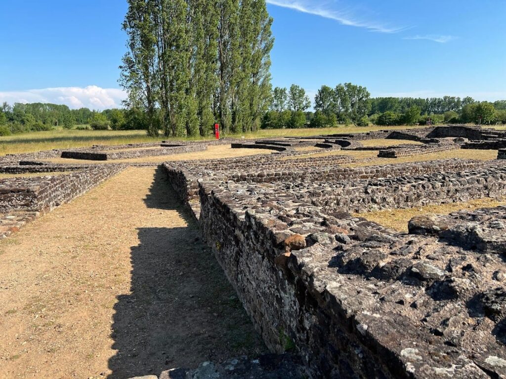
The Site Archéologique de Cherré comprises a complex of monumental structures primarily dating from the late 1st century CE through the 3rd century CE. The architectural ensemble is situated on a plateau overlooking the Loir River valley and is characterized by sandstone ashlar masonry combined with brick and mortar containing sandstone and flint nodules. Several buildings incorporated wooden superstructures, notably the theater’s seating and roofing elements in the market-forum. The absence of a formal street grid or permanent residential quarters indicates a specialized site focused on religious, commercial, and ritual functions rather than typical urban habitation. The complex expanded during the 2nd century CE through remodeling and enlargement of key buildings, followed by decline and partial abandonment by the early 4th century CE. The remains include well-preserved foundations, walls, and architectural details, with some structures partially reconstructed or stabilized for conservation.
Key Buildings and Structures
Theatre of Cherré
Constructed at the end of the 1st century CE and remodeled in the second quarter of the 2nd century CE, the theater features a semicircular plan approximately 63 meters in diameter. The cavea (seating area) consisted of wooden benches supported by concentric masonry arches, as confirmed by numerous nails and beam sockets. The external cavea wall survives locally up to 2 meters in height, though the upper seating tiers likely reached over 12 meters. Access was provided by three main radial vomitoria and four secondary entrances. The orchestra is separated from the seating by a balteus (low wall) up to 1 meter high. The stage building measures 10.60 by 5.20 meters and is centrally placed on the straight back wall, which extends 63 meters. Three niches decorate the inner face of the stage wall. Masonry comprises reddish sandstone blocks and bricks with finger marks and notches, bonded with mortar containing sandstone and flint nodules. Decorative lighter sandstone blocks adorn the cavea wall, stage wall, and vomitoria interiors. The base of the curved cavea wall includes stepped projections for structural reinforcement and ornamentation. The theater’s initial design follows a 36-foot square module, with main dimensions as multiples of this unit.
The 2nd-century remodeling added new semi-annular walls supporting seating, faced with lighter sandstone blocks; some walls intercalate with earlier structures, while others encroach on the orchestra, reducing its size. A loge (box) at a vomitorium exit may have served an elite individual or functioned as a small cult building base. The stage building was moved inward into the orchestra and subdivided by two internal walls, though the external dimensions remained unchanged. The theater is classified as a “Gallo-Roman theatre” type, characterized by a small stage building, light structure, and association with a sanctuary. It is notable for being built on flat ground rather than a hillside. The stage wall is not aligned with the temple’s enclosure wall, possibly deliberately constructed over protohistoric tumuli and megaliths. The theater shares the same orientation and alignment as other main monuments on site.
Market-Forum Building
Located west of the theater, this building was constructed at the end of the 1st century CE and enlarged about fifty years later. Initially, it was a large tile-covered hall with small square rooms at each end, possibly serving as offices for registration or payment. After remodeling, it became an open courtyard measuring approximately 68 by 42 meters, flanked on the long sides by two double covered galleries about 3.40 meters wide. These galleries opened onto the courtyard through a colonnade. Some walls are thin, indicating masonry bases for wooden superstructures with tile roofs.
Archaeological finds include around 24,000 butchered animal bone fragments, mainly cattle, as well as 15,000 oyster shells, personal items, tools, statuettes, sigillata pottery shards, and about 540 coins. The faunal remains show selective butchery, suggesting meat processing occurred on site. Merchant stalls likely occupied the galleries. A wooden fountain fed by an iron-hooped wooden pipe was located centrally in the original hall; the pipe extends over 100 meters westward, connecting to the aqueduct supplying the site. The building’s function has been debated, initially identified as a macellum (market), but later interpreted as a forum or place of economic exchange without political or administrative roles.
Grand Temple of Cherré
Constructed around the end of the 1st century CE under Emperor Domitian (81–96 CE), the grand temple is the principal religious structure of the site. It has a rectangular footprint measuring 27 by 15 meters. The cella (inner chamber) is square, approximately 7.60 meters per side, and may have reached up to 15 meters in height. The cella is surrounded on three sides by a gallery enclosed by a windowless wall; the east side opens onto a pronaos (porch) accessed by stairs. The temple rests on a podium with surviving large sandstone blocks. Its orientation aligns with sunrise on April 23 and August 19, dates corresponding to the Roman Vinalia festivals.
The cella’s roof was likely tiled, supported by an inscribed terracotta tile fragment interpreted as a tile maker’s accounting system. The pronaos features a hexastyle colonnade (six columns), with two columns on each lateral face connecting to the gallery wall; columns are spaced about 2.5 meters apart. The colonnade arrangement suggests a pseudoperipteral style, allowing circulation around the cella. Fallen wall sections enabled reconstruction of the exterior gallery wall decoration, which rises over 14 meters and consists of alternating light and dark sandstone blocks forming chevrons and herringbone patterns separated by rows of terracotta. Pilasters continue the rhythm of the pronaos colonnade on the exterior wall. Interior walls are decorated with multicolored frescoes depicting festoons, garlands, and stucco motifs, extending to the cella’s outer face.
A large square peribolos (enclosure) wall, 90 meters per side, surrounds the temple. This wall includes eight exedrae (niches) covered with tiles and open outward, a rare architectural feature comparable to Hadrian’s Library in Athens. Each exedra is framed by two pilasters similar to those on the gallery wall. The exedrae were likely decorated with painted tegulae (roof tiles) fixed to the walls. A formal entrance with a staircase measuring 4 by 2.5 meters is located in the north wall, providing access to a gallery building adjacent to the temple; this entrance aligns with a smaller, second temple to the north. A second probable entrance existed in the east wall facing the temple stairs, though no trace remains.
A rectangular basin measuring 9.43 by 4.70 meters with rounded short sides lies about 10 meters east of the temple entrance, slightly off-axis. The basin walls are built of small masonry and functioned to collect infiltration water from the peribolos. The basin was damaged by illegal excavation in 1974 but has been fully reconstructed. Architectural and decorative elements, including a fragment of a Victory statue found on site, suggest dedication to the imperial cult or a warrior cult. The temple’s design and decoration are more elaborate than nearby sanctuaries such as Mars Mullo at Allonnes.
Second Temple
Located north of the grand temple, this smaller temple has an approximate footprint of 12 by 9.5 meters. It is built on a podium accessed by stairs. The cella has not been identified. The building is separated from the grand temple by a marshy area that received protohistoric weapon deposits. This temple remains unexcavated.
Roman Baths of Cherré
Excavated between 1989 and 1991, the bath complex measures approximately 35 by 30 meters. Initial construction dates to the last quarter of the 1st century CE, with enlargement in the first half of the 2nd century CE. The enlargement added several rooms to the south, including an apodyterium (changing room) and a cold pool (frigidarium) with an external apse on the west side. The final plan is asymmetrical and centered, covering about 926 square meters. The entrance is on the east side, protected by a wooden awning supported on wooden posts.
A central palaestra (exercise courtyard) measuring 15 by 14.2 meters is surrounded on three sides by a triple portico. The west wing contains bathing rooms arranged from south to north: frigidarium, heated rooms, caldarium (hot bath) with a hot pool, and a cold pool at the end, following the typical bathing sequence. One large room in the west wing may have served as a gymnasium or exercise hall. Heated rooms were warmed by a hypocaust system (underfloor heating) fed by a praefurnium (furnace). Water drainage was managed by a dry stone conduit leading to a masonry channel partially equipped with latrines. Metal fixtures in T and L shapes were found, used to fix insulation and heating elements on walls.
At discovery, only the cold pool wall remained slightly standing; other rooms were leveled and materials removed, including hypocaust bricks later reconstructed. Fragments of marble, mosaic, stucco, and moldings were found but insufficient to reconstruct decoration. Marbles originated locally and from distant quarries such as Saint-Béat. A lime kiln and pits found in the bath courtyard likely relate to construction activities. Temporary structures such as huts and scaffolding post holes were also identified, probably linked to building works. Sigillata pottery shards with human and vegetal motifs were recovered.
Aqueduct of Cherré
The site is supplied by an underground aqueduct traced over 4.5 kilometers, following contour lines at altitudes between 50 and 55 meters. The masonry channel measures approximately 0.24 by 0.27 meters and is laid in a trench ranging from 0.3 to 5 meters deep, covered with white sandstone slabs. At least one inspection shaft has been identified. A wooden reservoir measuring 2 by 2 meters is located mid-slope west of the baths, regulating water pressure and distribution. No remains of the final aqueduct section near the site have been found, suggesting a possible aerial structure there. The aqueduct was constructed contemporaneously with the baths.
The main water source is the Fontaine de Chenon spring, with minor contributions from the Saint-Hubert spring at Coulongé. The modern source is no longer connected, and the aqueduct is now blocked. Estimated flow rate was about 15 liters per second, with high CO2 content preventing calcite deposits and reducing clogging risk. Water was distributed via wooden pipes with iron fittings and lead pipes, supplying the forum, baths, and possibly the porticoed building north of the temple. Overflow was likely directed to the bath drainage channel to flush latrines.
Drainage and Sewage
A drainage system west of the temple manages the marshy terrain and collects runoff. It includes wooden pipes bound with iron hoops and dry stone conduits covered with sandstone slabs. The drainage network connects to the temple basin. The peribolos floor consists of compacted limestone with a sand layer, and the temple surroundings are shaped as a glacis (sloping embankment) to divert rainwater. A collector west of the baths serves three functions: draining surrounding terrain, collecting temple runoff, and evacuating bath wastewater. This collector is built of small sandstone slabs covered by large sandstone slabs. The downstream section is partially arranged as latrines, identified by circular notched cover slabs. The collector is oriented toward the Loir River, though its downstream route remains unknown.
Large Porticoed Building North of Temple
Identified by aerial photography, this building measures about 40 meters in length and features galleries. It connects to the temple peribolos by a door in the north wall. As of 2016, it remains unexcavated. Its function is uncertain but may have served as lodging or reception for pilgrims, comparable to similar structures at Mauves-sur-Loire and Entrammes.
Other Buildings
At least four additional buildings have been identified by aerial surveys conducted in the late 1980s and early 1990s. Their dates, functions, and architectural details remain undetermined. One of these may have been a domus (house) or mansio (official lodging). Several other structures with unknown functions are located on the site but have not been studied in detail.
Roads and Pathways
Several road segments have been identified around the site, though they are scattered and not necessarily contemporaneous. No organized road network has been reconstructed from current data. A late 19th-century mention of a cardo-like (north-south) road has not been confirmed by recent studies. Two east-west aligned road segments appear to border the north side of the elongated building north of the temple. A 4-meter-wide alley leading to the temple stairs was identified, crossed by the temple courtyard basin. Two other roads, likely medieval or modern, include an east-west road with ditches partly overlying the elongated building’s footprint and a northeast-southwest road south of the site built with demolition debris from the baths.
Protohistoric Necropolis and Enclosures
Beneath the theater foundations lies a Hallstatt period necropolis dating to the 5th century BCE. At least eight tumuli have been found, some containing inhumations and one with an urn burial. Five fallen megaliths, one reshaped for theater construction, are present. The necropolis is dated to the late Hallstatt or early La Tène A period. Most graves are individual and involve cremation rites. Rare grave goods include glass beads. The necropolis extends beyond the theater footprint under the western galleries of the market-forum and under the northern part of the grand temple peribolos. The site represents a rare example of a collective cult site in western France during the Iron Age. Nearby, the fortified promontory known as the “camp de Vaux” was occupied from the 7th century BCE and features palisade remains. Several enclosures have been identified: a concentric ditch 61 meters long with a southern entrance about 70 meters north of the theater, possibly contemporary; a circular structure 20 meters in diameter south of the theater; a large trapezoidal double-ditch enclosure southeast of the temple; and an elongated structure southwest of the temple. These enclosures likely relate to burials and ritual deposits but remain undated due to lack of finds.
Protohistoric Weapon Deposits
Ritual weapon deposits dating from the early La Tène A1 period confirm the site’s warrior cult character. These deposits include animal bones (mainly skulls), ceramic shards, and 73 metal weapons such as swords, scabbards, handles, and fragments. Cauldron handles and fragments were also found. The deposits date from La Tène B2 to D phases. Animal bones are mainly domestic cattle and pigs. Decorated sword scabbards feature incised and curved motifs, including mythological animals typical of the middle and late La Tène. Four “currency-bar” axes, one socketed and measuring 50–60 cm, were found alongside spears and shield bosses. Many semi-finished metal domestic objects, such as cauldron handles, were also recovered. These deposits lie in sandy fill. Additional weapon deposits were found between the D305 road and the grand temple in a marshy area, accompanied by vessels and animal skulls, dated to late La Tène B2 to early C1 (3rd century BCE). These deposits are mostly short-lived and found in non-stratified soil layers.
Other Remains
Remains of medieval or Merovingian/Carolingian cemeteries have been found around the temple and near the baths. One necropolis near the temple contains 39 graves, mostly simple inhumations in earth pits or schist coffins. Another cemetery north of the site, known from earlier reports and an illegal excavation in 1975, contained 34 sandstone sarcophagi. An isolated early medieval grave was found near the baths. The site’s monumental stones were extensively quarried and reused in local Romanesque churches in nearby villages such as Aubigné-Racan, Coulongé, Vaas, and Verneil-le-Chétif, as well as in the former abbey church of Notre-Dame de Vaas.
Preservation and Current Status
The preservation of Cherré’s ruins varies by structure. The theater’s masonry walls and foundations remain visible, with some cavea walls preserved up to 2 meters high. Wooden seating elements have not survived but are confirmed by archaeological evidence. The market-forum’s foundations and gallery bases survive, though superstructures are absent. The grand temple’s podium, peribolos walls, and decorative masonry remain partially standing, with fresco fragments preserved in situ. The bath complex is largely leveled, with only the cold pool wall partially standing; hypocaust bricks have been reconstructed. The aqueduct and drainage systems survive as underground masonry channels and conduits. The large porticoed building north of the temple remains unexcavated but visible via aerial survey.
Conservation efforts have stabilized exposed masonry and earthworks. Some areas have undergone partial restoration, while others are preserved in situ. The site faces environmental challenges such as vegetation growth and erosion. Ongoing archaeological research and conservation are managed by regional heritage authorities. Several areas remain unexcavated or poorly studied, including the second temple north of the grand temple and the large porticoed building. Future excavations may be limited by conservation policies and the site’s protected status.


