Artaxata: The Ancient Capital of the Kingdom of Armenia
Visitor Information
Google Rating: 4.9
Popularity: Very Low
Google Maps: View on Google Maps
Country: Armenia
Civilization: Armenian, Roman
Remains: City
History
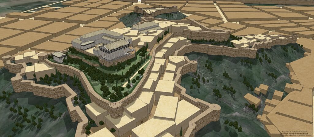
Artaxata was established between 188 and 176 BCE by King Artaxias I, the founder of the Artaxiad dynasty. It became the new capital of the Kingdom of Armenia, replacing the earlier city of Yervandashat. The site was chosen for its strategic position at the meeting point of the Araks and Metsamor rivers, situated on a peninsula formed by several hills. This location may have been previously occupied by an Urartian settlement, indicating a long history of habitation.
During its early years, Artaxata grew into a vibrant commercial and cultural hub. Its population was diverse, including Armenians, Greeks, Jews, and Syrians. The city was planned following Hellenistic urban design principles, featuring paved streets, public bathhouses, markets, workshops, and administrative buildings. It also hosted Armenia’s first theater. Ancient writers such as Plutarch and Strabo linked the city’s foundation and design to the famous Carthaginian general Hannibal Barca, earning Artaxata the nickname “the Armenian Carthage.”
Artaxata served as Armenia’s capital until around 120 AD, though its status was interrupted by wars and destruction. Under King Tiridates I, with Roman support from Emperor Nero, the city was briefly renamed Neroneia. Throughout its history, Artaxata was a contested site, suffering damage during conflicts involving Romans, Parthians, and Sasanians. Notable military events include its sacking by the Roman general Corbulo in 58–59 AD, occupation by Roman forces under Emperor Trajan around 114–117 AD, and destruction by Roman general Statius Priscus in 163 or 164 AD.
Following the relocation of the Armenian capital first to Vagharshapat and later to Dvin, Artaxata’s importance declined. The city endured further destruction by the Sasanian king Shapur II in the late 4th century and by Armenian forces aligned with the Sasanians in the mid-5th century. Environmental changes, including shifts in river courses and flooding, contributed to the city’s eventual abandonment.
Archaeological work began near the modern village of Artashat in 1970, revealing fortifications, public buildings, and artifacts spanning from the Hellenistic period to late antiquity. In 2024, excavations uncovered the oldest known Armenian church at the site, an octagonal structure with cruciform extensions dating to the mid-4th century. This building is believed to have served as a martyrion, a shrine built over the tomb of a Christian saint. Additionally, a Roman aqueduct bridge constructed by the Roman army between 114 and 117 AD was found, though it remained unfinished after Emperor Trajan’s death and the subsequent Roman withdrawal from Armenia.
Remains
Currently, not many remains of Artaxata have been excavated. Artaxata covered an area of approximately 400 to 500 hectares, built across more than ten hills. The highest hill, rising about 70 meters above the surrounding plain, hosted the acropolis. This acropolis featured a large triangular fortress with brick buttresses and Hellenistic-style turrets designed to support catapults. Defensive walls extended roughly 10 kilometers around the city, measuring about 3 meters thick. These walls were constructed from local red stone and gray marble. Natural rivers protected the city on three sides, while an artificial water-filled moat secured the fourth side.
The city’s layout followed Hellenistic urban planning, with paved streets connecting various public spaces. Bathhouses were found both on the acropolis and in the lower city areas. Markets, workshops, and administrative buildings were part of the urban fabric. The site also contained Armenia’s first known theater. Archaeologists uncovered remains of temples dedicated to the goddess Anahit, as well as to the deities Tir and Artemis. Numerous copper statues, marble sculptures, terracotta figurines, and finely crafted gold and silver jewelry were among the artifacts recovered. Decorated vessels and weapons, along with imported goods, indicate a rich cultural and commercial life.
A Roman aqueduct intended to supply water to Artaxata was discovered through geomagnetic surveys, drillings, satellite images, and drone infrared photography. The aqueduct’s monumental foundations and unfinished pillars date to the early 2nd century AD, built during the Roman occupation under Emperor Trajan. Inscriptions found at the site include Latin texts mentioning Trajan and the Fourth Legion Scythica, confirming Roman military presence and construction efforts.
Excavations also revealed residential complexes, workshops, and monumental architectural details. Late antique bathhouses were uncovered, showing continued use and modification of the city’s infrastructure over time. The mid-4th century church discovered at Artaxata has an octagonal core with four square extensions forming a cruciform shape. Carbon dating of wooden platforms within the extensions places the building in the mid-300s AD. This structure likely served as a martyrion, built over the tomb of a Christian saint.
Remains of bridges connecting Artaxata to the opposite bank of the Araks River were found, including one historically known as the “Taparakani” or “Artaxata Bridge.” These bridges facilitated communication and trade across the river, contributing to the city’s strategic importance.


