Mariana: An Ancient Roman Colony in Corsica


Visitor Information
Google Rating: 4.5
Popularity: Low
Google Maps: View on Google Maps
Official Website: www.musee-mariana.com
Country: France
Civilization: Roman
Remains: City

History
The archaeological site of Mariana is located in Lucciana, within the Haute-Corse department on the island of Corsica, France. It was established as a Roman colony in 93 BCE by the consul Gaius Marius. The colony likely replaced an earlier settlement known as Nicaea and was closely linked to the nearby military colony of Aléria. Mariana functioned primarily as a civilian settlement, although its legal status under Roman law may have been irregular and not formally ratified by the Senate.
During the Roman period, the inhabitants, called the Mariani, were settlers who displaced native Corsican populations toward the island’s interior highlands. Mariana and Aléria served as naval stations supporting the fleet based at Misenum, with a naval commander known as a trierarch overseeing operations. Over time, Mariana also became a center for agricultural training, helping to spread Roman farming techniques to surrounding communities.
The city remained inhabited and fortified through the 2nd and 3rd centuries CE, enclosed by defensive walls covering about thirty hectares. By the 4th century, Christianity had taken root, and Mariana became one of Corsica’s earliest bishoprics. Mariana declined during the early Middle Ages and was abandoned by the 7th century.
The episcopal basilica suffered destruction during invasions by Vandals and Lombards but was rebuilt in the Romanesque style. Initially, the diocese answered directly to the Pope, but from 1092 it came under the jurisdiction of Pisa, and later from 1130, under Genoa. The bishopric seat was eventually moved to Bastia in 1570.
Archaeological interest in the site began in the 1960s, with significant excavations uncovering early Christian structures such as a basilica and baptistery. Excavations resumed in the late 1990s but were paused in 2007. In 2017, a sanctuary dedicated to the cult of Mithras, known as a Mithraeum, was discovered nearby. The site is protected as a historic monument, with ongoing efforts to establish a museum supported by local authorities and the Principality of Monaco. Mariana is also linked to the veneration of Saint Devota, a martyr believed to have died there around 302 CE.
Remains
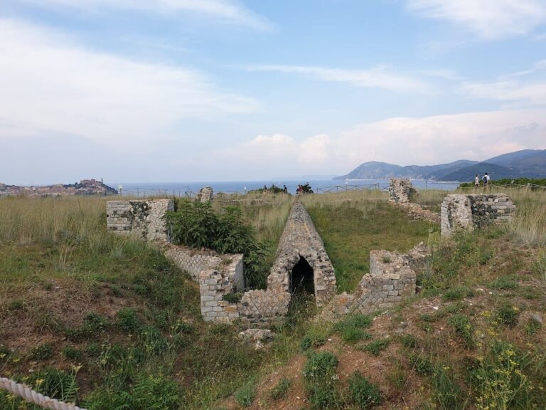
Mariana’s remains cover roughly thirty hectares and are enclosed by a trapezoidal defensive wall dating from the 2nd to 3rd centuries CE. The city’s layout follows a grid pattern with two main streets: a north-south cardo and an east-west decumanus. The decumanus was lined with porticoes, providing shelter for shops and commercial activities.
A paleochristian complex, including a basilica and baptistery, was uncovered along the porticoed street. These structures date from the 4th to 6th centuries CE and reflect the early Christian presence in the city. After destruction by invading groups, the episcopal basilica was rebuilt in the Romanesque style.
The cathedral of Santa Maria Assunta, also called La Canonica, was consecrated in 1119. Its architecture shows similarities to churches in Lucca and northern Sardinia, indicating regional influences. Nearby stands the 12th-century church of San Parteo, which shares these Romanesque features.
Archaeological finds also include a Mithraeum discovered in 2017, dedicated to the ancient Roman mystery cult of Mithras. Additionally, a small rural necropolis from the 3rd century CE was found at Mezzana, about three kilometers from Mariana, likely connected to a nearby agricultural estate.
The Roman road linking Mariana to Palla (probably modern Bonifacio) ran along Corsica’s eastern coast. Built after the reign of Emperor Augustus, this paved route appears in the Antonine Itinerary, an ancient Roman road register, but is absent from the Peutinger Table, a medieval map of Roman roads.
Today, visible remains include sections of the city walls and parts of the urban grid. Non-intrusive archaeological methods such as magnetometry have been used to map buried structures near the cathedral complex, aiding preservation and study without excavation.