Sardis Ancient City: Capital of Lydia and Persian Anatolian Gateway


Site at a Glance
- Rating
- 4.7
- Popularity
- Medium
- Country
- Turkey
- Primary era
- Classical
- External website
- Open
- Eras represented
- Iron Age, Classical, Medieval
- Civilizations
- Achaemenid, Ancient Greek, Byzantine, Lydian, Roman
- Site type
- City
On this page23 sections
History
Sardis Ancient City is an ancient urban center in Türkiye, near Salihli, whose history extends from the Late Bronze Age into the Byzantine period. Settled before 1500 BC and later developed by the Lydians, Sardis became the capital of Lydia during the Iron Age and grew wealthy through gold working, metal production, and coinage. Its position between the Aegean coast and the Anatolian interior also made it a major political and communications center.
Bronze Age origins and Lydian capital
Sardis was occupied for at least 3,500 years, alternating between periods as a wealthy city of international importance and periods as a smaller settlement. Scattered pottery fragments may indicate Neolithic activity, although their original context is uncertain. The site was certainly settled by the Late Bronze Age, when it lay within the Seha River Land. This territory had once formed part of Arzawa, a large political region in western Anatolia, before the Hittite king Mursili II defeated and divided it. Seha later became a Hittite vassal state and an intermediary with the Mycenaean Greeks. The relationship between the people of Seha and the later Lydians remains uncertain, since both cultural continuity and disruption are visible.
Later traditions attributed the foundation of Sardis either to the Heracleidae, described as the sons of Heracles, or to the Lydian king Gyges. The city may have been the place called Hyde by Homer and Strabo, although that identification is not certain. Sardis is first mentioned in writing in Aeschylus’ Persians, while the name Sardis appears in the work of Sappho.
Around 680 BC, Gyges overthrew Candaules, founded the Mermnad dynasty, and made Sardis the capital of Lydia. Lydian kings, including Croesus, ruled an empire that extended eastward to the Halys River. Sardis prospered partly because of the gold-bearing alluvial deposits of the Pactolus valley, as well as metalworking and the production of coinage. Lydian workshops began producing coins around 560 BC, helping to establish a monetary system associated with the city.
The Cimmerians attacked the lower city during the Lydian period, but the acropolis resisted capture. Sardis reached its greatest wealth under Croesus, whose reign is generally placed around 560 to 547 BC. The population of the city in the sixth century BC has been estimated at approximately 20,000 to 50,000 people, in addition to settlements in the surrounding area.
Persian rule and the Ionian Revolt
Cyrus the Great, founder of the Achaemenid Persian Empire, conquered Sardis around 547 BC after defeating Croesus at Pteria and Thymbra. Following a brief siege, the Persian army sacked the city. Fire destroyed the fortifications and neighboring residential areas, while surviving archaeological evidence preserves signs of violent fighting and civilian resistance.
After the conquest, Sardis was rebuilt as the capital of Sparda, a Persian provincial administration governed by a satrap. It was also the western terminus of the Persian Royal Road from Persepolis and an important communications gateway between the Aegean and the Anatolian interior. Persian kings including Darius I and Xerxes I visited the city, as did Greek leaders such as Lysander and Alcibiades.
In 499 BC, during the Ionian Revolt, Ionians and Athenians attacked and burned Sardis. The revolt was a rebellion by Greek cities in western Anatolia against Persian rule, and the attack helped prompt Darius I’s later war against Athens. Persian forces were subsequently assembled at Sardis for campaigns against Greece, including Xerxes’ expedition of 480 BC. Cyrus the Younger also gathered troops there before marching against his brother Artaxerxes.
Alexander and the Hellenistic kingdoms
In 334 BC, after the Persian defeat at Granicus and the death of the satrap Mithrenes, Sardis surrendered to Alexander the Great. Alexander restored earlier Lydian customs, laws, freedoms, and institutions. During the next two centuries, control of the city passed among Hellenistic rulers and dynasties, including Antigonus Monophthalmus, Lysimachus, the Seleucids, and the Attalids.
Sardis endured sieges by Seleucus I in 281 BC and Antiochus III in 215 to 213 BC, but neither assault breached the acropolis. Under Hellenistic rule, the city became strongly Greek in language, institutions, and architecture while retaining elements of its Lydian identity. Antiochus III settled Jews at Sardis, creating a community that continued through much of Late Antiquity.
Roman prosperity and Christian Sardis
In 129 BC, Sardis passed to Rome and became part of the province of Asia. It remained prosperous and politically influential, although Ephesus took precedence as the province’s leading administrative center. A devastating earthquake in AD 17 damaged the city. The emperors Tiberius and Claudius supported its reconstruction, and Sardis received three neocorate honors, meaning civic honors for hosting an imperial cult devoted to emperors and members of the imperial household. The city also received ten million sesterces and a temporary exemption from taxes.
Sardis had an early Christian community and was one of the seven churches of Asia named in the Book of Revelation. It remained the seat of the metropolitan bishop of Lydia and hosted several church councils during the early Christian centuries.
Decline, abandonment, and archaeology
Sardis declined from the sixth century onward. During the Byzantine-Sasanian War, a Persian invasion under Shahin sacked the city around AD 615 to 616, and the damage was never fully repaired. Sardis remained Byzantine until its loss to the Seljuk Turks in 1078. The Byzantine general John Doukas reconquered it in 1097, after which it later belonged to the Empire of Nicaea.
After the Byzantine recovery of Constantinople in 1261, Sardis and its surrounding territory gradually came under the control of Ghazi emirates. The citadel and nearby valleys were transferred to them by treaty in 1306. Timur captured and probably destroyed the city in 1402. By the eighteenth century, only two small hamlets remained at the site.
Cyriacus of Ancona identified the ruins in 1426. By the nineteenth century, Sardis was largely ruined, and Roman remains were the most visible. George Dennis was among the early excavators. The Princeton expedition led by Howard Crosby Butler excavated the Temple of Artemis from 1910 to 1914 and briefly resumed work in 1922.
The Archaeological Exploration of Sardis was founded in 1958 by George M. A. Hanfmann and Henry Detweiler. Its work included excavation and restoration of the Roman bath-gymnasium complex, the synagogue, late Roman houses and shops, Lydian industrial areas, occupation levels, and the tumuli of Bin Tepe. Excavations continued under Crawford H. Greenewalt Jr. from 1976 to 2007 and under Nicholas Cahill from 2008 onward. The archaeological area of Sardis and the Lydian tumuli of Bin Tepe were inscribed as a UNESCO World Heritage Site in 2025, in part because of Sardis’ association with the development of coinage.
Remains
Sardis occupied the middle Hermus Valley, approximately 4 kilometres south of the Hermus River. Its citadel stood on a steep spur of Mount Tmolus, while the lower city extended toward the Pactolus stream. The site lay along an important route between the Aegean coast and the Anatolian interior, and the Pactolus valley was known in antiquity for its gold-bearing sand. The city covered about 108 hectares, including areas outside its main boundaries. Excavated remains reveal Lydian, Hellenistic, Roman, Jewish, and Byzantine phases, although the overall layout is still incomplete.
Acropolis and urban districts
Acropolis fortifications
The acropolis rose about 457 metres above its surroundings on extremely steep slopes. Its mass consisted of compacted gravel rather than solid rock, yet ancient writers celebrated its strength. Landslides have removed most of the walls, but three pre-Hellenistic wall sections survive beneath later Byzantine fortifications on the southern side. The mountainside was terraced with white ashlar masonry, or carefully cut stone blocks, to regularize its irregular form. Triple walls protected the acropolis, while the lower city also possessed substantial fortifications that reportedly reached up to 20 metres in thickness.
Lydian neighborhoods and workshops
The northern and northwestern districts outside the main fortified area contained residential, commercial, and industrial zones extending toward the Pactolus. Lydian houses generally used fieldstone and mudbrick, with roofs made of clay and straw. Wealthier houses had tiled roofs. Courtyards and food-preparation areas can be identified, while the surviving evidence gives only a partial picture of interior organization.
A seventh-century BC commercial quarter consisted of shops within a walled complex. Another Lydian bazaar, south of the modern highway, occupied an open area enclosed by a stone wall, of which about 33 metres survives. The area included single-room houses or commercial spaces. East of the Pactolus, more developed courtyard-like compounds stood beside industrial installations. Workshops dating approximately from 600 to 547 BC processed electrum and separated gold and silver from base metals in pits and furnaces. Other Lydian houses lay northeast of the Temple of Artemis.
Lydian religious features
A modest altar in an area outside the main city may have been dedicated to Cybele, an Anatolian mother-goddess associated with mountain, fertility, and civic worship, because a pottery fragment bearing her name was found there. A possible sanctuary of Artemis, the Greek goddess whose Sardian cult incorporated eastern Anatolian features, included marble lion statues. Buried dinner services in extramural areas indicate local offering practices.
Streets and the Temple of Artemis
Hellenistic and Roman streets
The Hellenistic city plan included a major street running diagonally from the Pactolus toward the northeastern corner of the city. The later Roman main street crossed it diagonally and ran northwest to southeast. It was paved with marble and bordered by colonnades. Parts of the street lie beneath and north of the modern highway, where they form part of the surviving urban arrangement.
Temple of Artemis
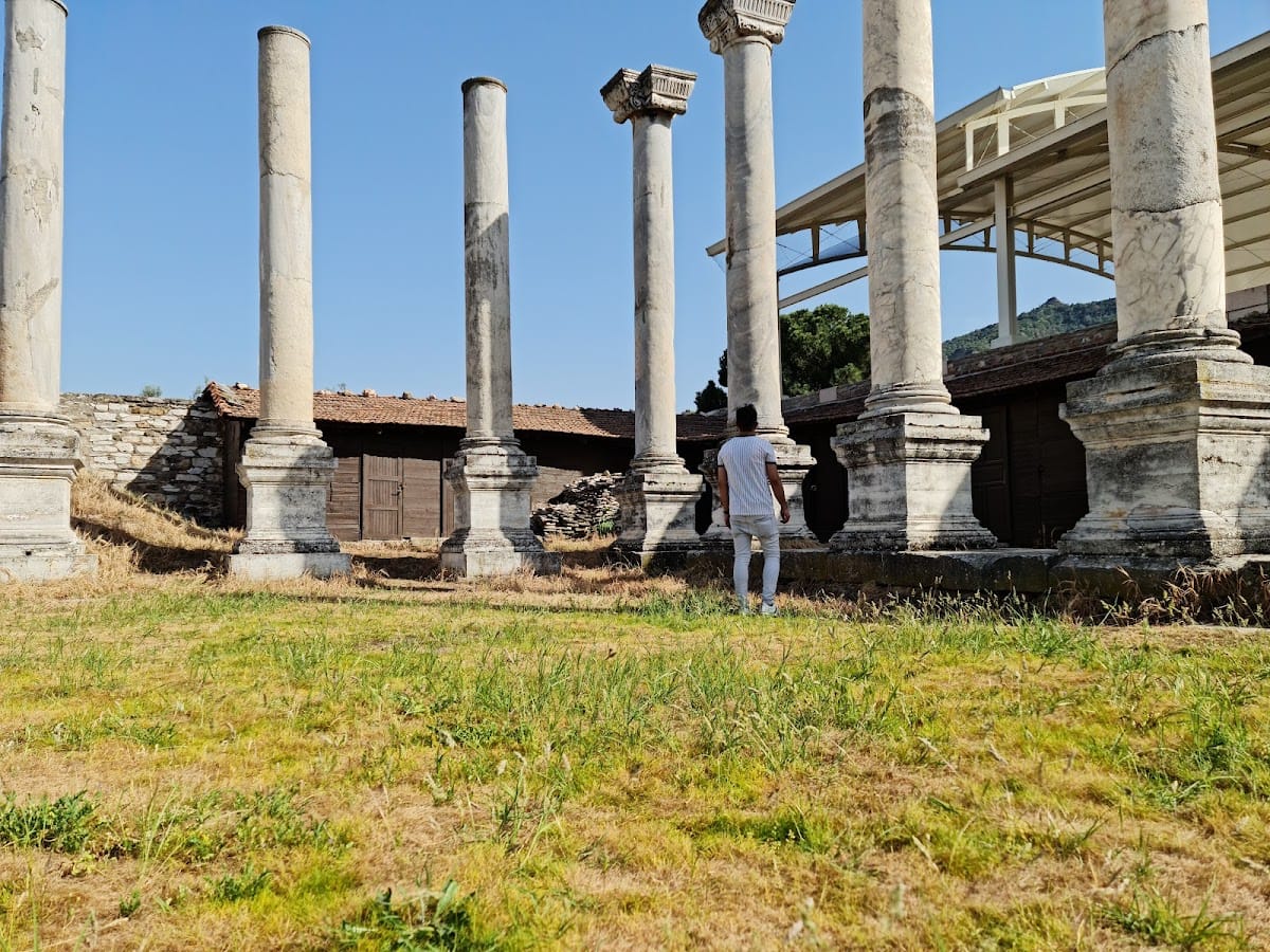
The Temple of Artemis stands west of the acropolis, outside the main city and on the east bank of the Pactolus. It is a large Ionic temple of Hellenistic origin, probably begun around 300 BC, and was altered during the Roman period. The temple measured approximately 45.73 by 99.16 metres at the stylobate, the upper platform supporting the columns. It was designed with eight columns across the front and twenty along each side, with columns nearly 20 metres high. Two columns remain standing to their full height, while thirteen others survive in part.
The earliest phase consisted of a central cella, or sacred chamber, with a western pronaos, the front porch, and an eastern opisthodomos, the rear chamber or portico. The pronaos originally held two rows of three columns. Inside the cella, two rows of columns divided the space into three aisles, with a central base for a statue of Artemis and Cybele. The temple opened westward, following an Anatolian orientation rather than the more usual Greek arrangement.
During the second quarter of the second century BC, builders began the peristasis, the surrounding colonnade, but never completed its eastern side. The pronaos and opisthodomos were remodeled into symmetrical spaces measuring about 18.30 by 13.70 metres, and a wall later divided the cella into two equal parts. This arrangement created two opposing temple fronts and accommodated a double cult.
In the Roman period, one part of the temple continued the earlier cult, while the other held the colossal statue of Faustina the Elder. Around AD 140, the cella was divided for imperial worship. The eastern part was dedicated to Antoninus Pius and the imperial cult, while the western part was dedicated to Faustina, possibly together with Artemis. A church was built on the site in the fourth century. The temple remains are relatively well preserved.
Theater, stadium, and Roman public buildings
Greek theater and stadium
The Greek theater is generally dated to the early Hellenistic period, although it was also said to have originated in the fifth century BC. It stood north of the acropolis and south of the modern highway. Its auditorium was about 136 metres in diameter and may have held approximately 11,000 to 20,000 spectators. A stadium occupied the nearby slope.
The theater was renovated in the early imperial period and again after the earthquake of AD 17. Later Roman work remodeled the Greek building, with remains of the Roman phase dating to the third century AD and an estimated capacity of about 20,000 spectators. The stadium used the natural southern slope of the hill and was supported on its western side by massive Roman vaulted structures.
Bath-gymnasium complex
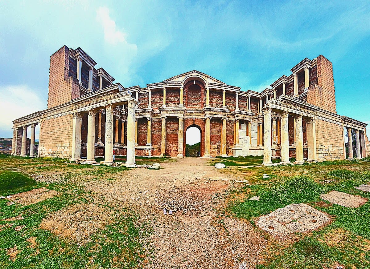
North of the Roman main street stood a bath-gymnasium complex covering about 23,000 square metres. Developed in stages during the later second and early third centuries AD, it contained baths to the west, a gymnasium to the east, and a large central palaestra, an exercise court associated with a Greek or Roman gymnasium.
The principal bath area was complete by AD 166, according to an inscription dedicated to Lucius Verus. It contained halls with apses, semicircular or polygonal ends, and a monumental eastern hall now called the Marble Court. An inscription dedicated to Caracalla, Geta, and Julia Domna dates its façades to AD 211. The building was repaired during the early Byzantine period and conserved up to the level of the second storey between 1964 and 1973.
Other Roman and Byzantine structures
A Roman administrative center, a Roman odeon, and a Roman basilica with apses at both ends formed part of the wider public district. Foundations may belong to a large cathedral of the reign of Justinian. A continuous row of early Byzantine shops, dating approximately from 400 to 600, stood south of the bath-gymnasium along the main street. One shop contained a marble water tank decorated with crosses. South of a Byzantine bridge over the Pactolus are the remains of a Roman bath and a small Middle Byzantine church built above the Lydian gold-working district.
Sardis Synagogue
The Sardis Synagogue occupied a prominent position within the bath-gymnasium complex, between the palaestra and the main street. It was in use from approximately AD 200 to 616. The building had a basilica-like plan, meaning a long central hall organized in the manner of a basilica, with an eastern peristyle forecourt and a western main hall about 50 metres long that ended in an apse.
Six pairs of pilasters divided the main hall into seven bays. Three rows of marble benches stood in the apse. Ritual furnishings included a large marble table supported by relief-decorated eagles and two pairs of facing lions. Mosaics covered the floors, and marble faced the walls. The partly conserved ruins include inscriptions, menorahs, and other evidence of Jewish use.
Tumuli and tombs
Bin Tepe cemetery
The Bin Tepe tumulus cemetery lies about 6.5 kilometres north of Sardis, across the Hermus and south of Lake Gyges. A tumulus is an artificial burial mound. About 149 mounds were known in the 1940s, while approximately 115 are now known, with some destroyed by agriculture. The cemetery forms part of the wider archaeological heritage associated with Sardis.
Koca Mutaf Tepe, the largest of three major tumuli, is traditionally identified as the tomb of Alyattes. Probably built in the late seventh or early sixth century BC, it measures about 355 metres in diameter and 63 metres in height and contains an estimated 785,000 cubic metres of earth and stone. Its former retaining wall was made of enormous stones, and a small marble-lined burial chamber was placed off-center.
Karnıyarık Tepe is traditionally identified as the tomb of Gyges. It measures about 230 metres in diameter and 53 metres in height. Its date, no earlier than the sixth century BC, makes the traditional attribution problematic. The mound contains a limestone krepis wall, a stepped retaining structure, surrounding a smaller inner mound.
Rock-cut tombs and burial monuments
Hundreds of Lydian rock-cut chamber tombs have been found along the Pactolus and on the slopes of the acropolis. Their rectangular chambers contained painted terracotta sarcophagi and were closed with stone slabs. Painted stelae marked the entrance corridors. A stepped limestone structure known as the pyramid tomb represents a Persian-period burial monument.
Sculpture and excavated objects
A colossal marble head of Faustina the Elder, 1.76 metres high, was found in the precinct of the Temple of Artemis. It probably belonged to a pair of colossal statues representing the imperial couple and is now held by the British Museum. Excavations at Sardis also recovered Lydian and Greek pottery, bronze fibulae, an iron implement, weapons, household tools, industrial installations, and human remains associated with episodes of destruction. Finds from the city are distributed among archaeological collections in Istanbul, Izmir, New York, Princeton, and Manisa.