Ptolemais Archaeological Park: A Historic Urban Center in Cyrenaica, Libya
Table of Contents
Visitor Information
Google Rating: 4.3
Popularity: Low
Google Maps: View on Google Maps
Official Website: ptolemais.pl
Country: Libya
Civilization: Byzantine, Greek, Roman
Remains: City
Context
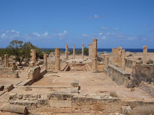
Ptolemais Archaeological Park is situated at Tolmeita on Libya’s northeastern Mediterranean coast within the historic region of Cyrenaica. The site occupies a coastal plain adjacent to a rocky promontory, with access to fertile hinterlands and seasonal wadis that influenced ancient water management and land use. Its position near the Gebel al Akhdar mountain range provided a natural corridor connecting the coast to inland cities such as Cyrene, facilitating trade and communication across the region.
Archaeological evidence indicates that Ptolemais was founded during the Hellenistic period under Ptolemaic influence, with continuous occupation documented through the Roman imperial era and into Late Antiquity. Inscriptions, coinage, and material culture attest to its role as a regional urban center and Christian bishopric during the Byzantine period. Stratigraphic layers reveal a decline in occupation following the seventh century CE.
The site preserves extensive urban remains, including a well-defined street grid and coastal installations visible in surface surveys. European and Libyan travelers first recorded the ruins in the nineteenth century, while systematic archaeological investigations in the twentieth and twenty-first centuries have mapped the city plan and recovered many artifacts.
History
Ptolemais Archaeological Park reflects a complex historical trajectory shaped by successive cultural and political influences in northeastern Libya. Originating as a Greek coastal settlement, it was transformed into a planned city under the Ptolemaic dynasty and later integrated into the Roman provincial system. The city maintained regional significance through Late Antiquity as a Christian episcopal center before experiencing decline after the Arab conquests. Its archaeological record documents a millennium of urban development, cultural diversity, and administrative evolution.
Greek Settlement and Early Development (7th century BC – mid 3rd century BC)
The earliest phase of occupation at Ptolemais dates to the 7th century BCE, when it functioned as a Greek harbor town serving the inland city of Barka, located approximately 24 kilometers inland. Its coastal location provided access to a natural pass ascending the Gebel al Akhdar mountains toward Cyrene, facilitating trade and communication within the Pentapolis, a league of five prominent Cyrenaican cities. The settlement controlled a strategic segment of the road connecting Cyrene to the coast, underscoring its role in regional connectivity and commerce. This early harbor town laid the groundwork for the later urban expansion and planning that characterized Ptolemais.
Hellenistic Period (mid 3rd century BC – 1st century BC)
During the Hellenistic era, the original Greek settlement was replaced by a newly founded city named Ptolemais, established under the Ptolemaic dynasty, likely by Ptolemy I or Ptolemy III. This foundation was part of the Ptolemies’ broader policy of establishing dynastic cities and naval bases across the eastern Mediterranean to consolidate control and project power. The city was designed according to contemporary Greek urban planning principles, featuring an orthogonal grid with major north-south streets intersected by a principal east-west avenue known as the Street of the Monuments.
The harbor, located on the eastern side of the city and aligned with the main avenue, included a lighthouse situated on a nearby promontory. Archaeological discoveries such as a submerged pier and a shipwreck attest to active maritime trade. A prominent tower-tomb known as the ‘Royal’ Mausoleum, over 15 meters high and stylistically related to the Mausoleum at Halicarnassus, likely dates to this period and may have served as the burial site for Ptolemy VIII Physcon Euergetes II, who ruled Cyrenaica in the 2nd century BCE. Surrounding the city, rock-cut tombs bearing inscriptions in multiple languages reflect the ethnically diverse population, including Libyan, Greek, Roman, Jewish, and Christian communities.
Roman Period and Imperial Roman Era (1st century BC – 4th century AD)
Following Roman annexation, Ptolemais retained its Hellenistic urban grid and architectural character, experiencing significant prosperity, particularly after the 262 CE earthquake severely damaged nearby Cyrene. Under Emperor Diocletian’s administrative reforms in the early 4th century CE, Ptolemais was designated the capital of the newly created province of Libya Superior or Pentapolis, surpassing Cyrene in regional importance.
The city featured typical Roman public amenities, including an amphitheater, a hippodrome, and three theaters. The smallest theater, an odeon, was adapted in the 4th or 5th century CE for water spectacles, a form of aquatic entertainment. Public and private baths were present, with some private residences containing their own bathing facilities. Excavations have uncovered Roman villas richly decorated with mosaics and frescoes, such as a 3rd-century villa owned by a man named Leukaktios, featuring geometric and figural mosaics depicting Dionysus and Ariadne. Domestic architecture shows continuity from the Hellenistic period, with some houses expanded to include audience halls and reception areas.
Water infrastructure remained vital, with numerous cisterns supplying both public and private needs. Archaeological evidence indicates that pottery and metallurgical workshops operated from the 4th to 6th centuries CE. A hoard of 568 Roman coins, including sesterces and silver denominations, was discovered in 2006 within an industrial complex linked to a villa, providing insight into the city’s economic activity during this period.
Early Christian and Late Antique Period (4th century AD – 7th century AD)
During Late Antiquity, Ptolemais emerged as an important Christian bishopric within the province of Libya Superior. Notable bishops included Arius, whose theological views led to the Arian controversy condemned at the Council of Nicaea in 325 CE; Secundus, a patron of Arius; Synesius, bishop circa 407–413 CE; his brother Evoptius, participant in the Council of Ephesus in 431 CE; and Georgius, signatory of the Second Council of Constantinople in 553 CE. Two Christian basilicas dating to the 6th century CE attest to the established Christian community and religious architecture.
The city’s urban layout and monumental buildings largely preserved the Hellenistic plan, with limited new construction. The adaptation of the smallest theater for water spectacles during the 4th or 5th century reflects evolving entertainment practices. The city endured periodic earthquakes, notably in the mid-3rd century and in 365 CE, which influenced rebuilding efforts and contributed to the decline of some elite residences. Over time, Ptolemais’ regional importance waned, with Apollonia (Sozusa) eventually replacing it as the provincial capital.
Islamic and Medieval Period (7th century AD – 14th century AD)
Following the Arab conquest of North Africa in the 7th century CE, Ptolemais continued to be occupied, though its prominence diminished. Archaeological and textual evidence indicates habitation from the late 10th to early 13th centuries. Arab writers from the 9th, 12th, and 14th centuries mention Ptolemais as an anchorage and trading post, suggesting its ongoing role in regional maritime commerce during the medieval Islamic period. Some ancient rock-cut tombs were repurposed as quarries during this time, reflecting changes in the urban landscape. No records indicate major military confrontations or sieges at the site during this period.
Italian Colonial Period and Modern Rediscovery (20th century – present)
In the early 20th century, during Italian colonial rule, a new town was established near the ancient harbor of Ptolemais. Italian military fortifications and small forts were constructed in the area. Systematic archaeological investigations began under Italian teams and later continued by American, British, and Polish missions. Since 2001, the Polish Institute of Archaeology at Warsaw University has conducted extensive excavations focused on uncovering an entire insula to better understand domestic architecture from the Hellenistic period through the Arab arrival in the 7th century CE. These excavations have revealed richly decorated houses, cisterns, and evidence of industrial workshops.
The Polish mission has conserved numerous mosaics, paintings, coins, and sculptures, with plans to display these finds in a local museum near the site entrance. Over 1,000 coins have been recovered, including the significant 2006 hoard, contributing to the study of Cyrenaican coinage and economic history. Today, the site is protected by Libya’s Department of Antiquities under Antiquities Law No. 3. A local office manages the site and museum, though the absence of a defined buffer zone poses challenges due to proximity to modern and Italian-era settlements. Ptolemais remains a unique example of Hellenistic urban planning preserved through centuries, reflecting the diverse cultural traditions of Cyrenaica.
Daily Life and Importance by Period
Hellenistic Period (mid 3rd century BC – 1st century BC)
The transformation into the city of Ptolemais under Ptolemaic rule brought increased urbanization and social complexity to Ptolemais. The population expanded to include Macedonian Greek settlers, local Libyans, and other ethnic groups such as Jewish and possibly Phoenician residents, as indicated by multilingual funerary inscriptions. Elite families occupied large peristyle houses like the Palazzo delle Colonne, reflecting a stratified society with wealthy landowners and administrators at the top, alongside artisans and laborers.
Economic life diversified with intensified agriculture: grain, olives, and vineyards cultivated in the hinterland, and flourishing maritime trade supported by the harbor and lighthouse. Workshops producing pottery, metal goods, and textiles operated within the city, often at household or small industrial scale. The aqueduct and extensive cistern system ensured reliable water supply for domestic, public, and industrial use.
Interior decoration was sophisticated, featuring frescoes and mosaics with Alexandrian motifs, as seen in the Villa of the Four Seasons and House of the Triapsidal Hall. Markets likely offered imported luxury goods alongside local produce, with trade facilitated by sea routes connecting Ptolemais to Egypt, the Aegean, and North Africa. Religious practices combined traditional Greek cults with emerging syncretic elements; the presence of Jewish and early Christian communities suggests religious plurality. The city functioned as a dynastic foundation and naval base, with civic administration aligned to Ptolemaic governance, possibly including magistrates overseeing urban planning and trade regulation.
Roman Period and Imperial Roman Era (1st century BC – 4th century AD)
Under Roman rule, Ptolemais retained its Hellenistic urban fabric while evolving into a prosperous provincial capital. The population included Roman settlers, local Greeks, Libyans, and other ethnicities, with social hierarchy encompassing senators, equestrians, merchants, artisans, and slaves. Named individuals such as Leukaktios, owner of a richly decorated villa, attest to a wealthy elite engaged in local governance and economic activities.
Agriculture remained central, with grain, olives, and vines cultivated extensively. Industrial workshops for pottery and metallurgy operated at larger scales, often linked to villa estates. Maritime trade flourished, especially after the 262 CE earthquake damaged Cyrene, shifting regional prominence to Ptolemais. Public amenities such as baths, theaters, an amphitheater, and hippodrome supported civic life and entertainment.
Domestic interiors featured mosaic floors, frescoed walls, and private baths, often arranged around peristyle courtyards with reception halls for social gatherings. Markets and fora provided venues for commerce, offering local and imported goods such as ceramics, textiles, and foodstuffs. Transport combined sea trade with road networks, including the Roman road to Cyrene.
Religious life integrated traditional Greco-Roman deities and growing Christian communities, with public buildings and private homes reflecting this diversity. Administratively, Ptolemais became the capital of Libya Superior under Diocletian, governed by provincial officials and local councils, maintaining its role as a regional political and economic center.
Early Christian and Late Antique Period (4th century AD – 7th century AD)
The city’s population during Late Antiquity included Christian clergy, local elites, artisans, and rural inhabitants, reflecting a community increasingly shaped by ecclesiastical structures. Prominent bishops such as Arius, Synesius, and Georgius indicate an active Christian leadership engaged in theological debates and regional councils. Family and social roles adapted to Christian norms, with growing emphasis on charity and communal worship.
Economic activities continued with agriculture, artisanal production, and trade, albeit at a reduced scale compared to the Roman peak. Workshops for pottery and metalworking persisted into the 6th century. Food consumption remained consistent with Mediterranean staples, while clothing styles incorporated modest Christian influences. Christian basilicas and ecclesiastical buildings became focal points for worship and community gatherings, supporting catechetical instruction and liturgical life. The city’s civic role shifted from imperial administration to ecclesiastical leadership, with the bishopric serving as a key institution amid declining urban prominence. Transport and trade diminished but continued regionally. The city’s decline accelerated after repeated earthquakes and political changes, with Apollonia eventually supplanting Ptolemais as provincial capital. Nonetheless, the preservation of the urban grid and monumental architecture attests to continuity in civic identity and religious significance through this period.
Islamic and Medieval Period (7th century AD – 14th century AD)
Following the Arab conquest, Ptolemais experienced demographic and cultural shifts but maintained a modest population engaged in maritime commerce and local subsistence.
Remains
Architectural Features
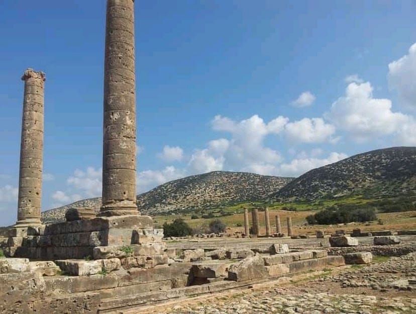
Ptolemais was enclosed by extensive defensive walls encompassing over 200 hectares, constructed primarily during the Hellenistic period and maintained through Roman and Byzantine times. The city’s layout follows a well-defined orthogonal grid plan, with major streets oriented north-south intersected by a principal east-west avenue known as the Street of the Monuments. This main thoroughfare terminated at a triumphal arch dedicated to Emperor Constantine the Great, erected in 311–312 CE, and a portico marking its eastern end. Large city blocks, or insulae, measured approximately 36.5 by 182.5 meters (100 by 500 Ptolemaic feet). Although much of the urban area within the walls remains unexcavated, recent surveys and excavations have expanded understanding of the city’s plan and structure.
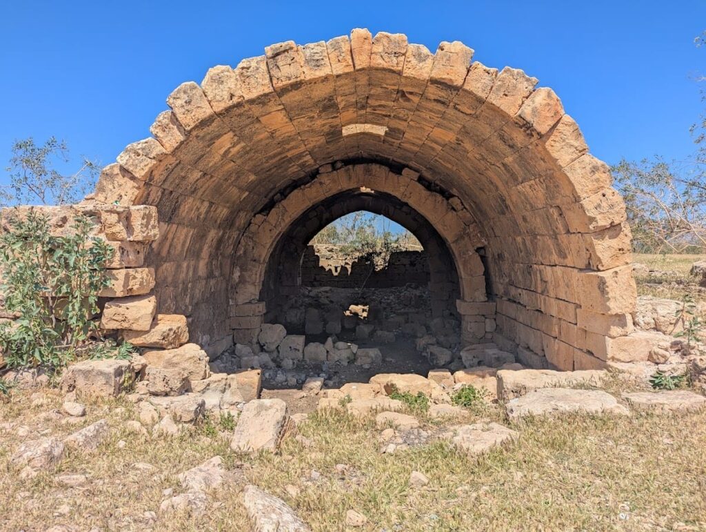
Construction techniques included ashlar masonry and vaulted rooms, with many buildings featuring peristyle courtyards. Water management infrastructure was a prominent feature, including an aqueduct channeling spring water from about eight kilometers east, supported by numerous public cisterns and reservoirs. The best-preserved hydraulic system is the Square of the Cisterns, a complex of seventeen vaulted cisterns with a combined capacity of approximately 7,000 kiloliters. Remains of a bridge carrying both the aqueduct and a road across the Wadi Ziwanah survive outside the city walls, illustrating the engineering supporting urban water supply.
Key Buildings and Structures
Palazzo delle Colonne
Originally constructed during the Hellenistic period, the Palazzo delle Colonne was remodeled in the first century CE to include a large pillared courtyard. The architectural decoration and pillared courts exhibit Alexandrian influence, reflecting cultural connections with Alexandria and the broader Hellenistic world. Excavations have uncovered numerous Egyptian statues within the residence, indicating elite status and cultural syncretism. The Polish archaeological team has focused on this insula, revealing domestic architecture spanning from the Hellenistic period through to the 7th century CE.
Villa of the Four Seasons
This large peristyle house was built during the Hellenistic period and refurbished in the Late Roman period. It features richly decorated frescoes and mosaic floors. The villa included private bathing facilities, indicating high-status domestic amenities. The layout centers on a courtyard surrounded by colonnades, typical of elite residences of the era.
House of the Triapsidal Hall
Constructed in the Late Roman period, this residence is notable for its architectural complexity, including audience halls and reception areas. The building’s decoration is elaborate, though specific mosaic or fresco details have not been extensively documented. Its plan reflects adaptations to social functions during the later phases of the city’s occupation.
Residential Insula Excavated by Polish Team
Excavations uncovered a well-preserved house dated to the 3rd century CE, centered around a four-column peristyle courtyard. The courtyard and adjoining dining rooms contain mosaics with geometric motifs and figural scenes, including a depiction of sleeping Ariadne, Dionysus, and his thiasus. Two mosaics bear the name of the villa owner, Leukaktios. Walls were decorated with colorful frescoes imitating marble revetments and featuring geometric designs and bird motifs. South of the residential area, a complex of rooms arranged around a small atrium served as living quarters and storage, including large containers for agricultural products. Several cisterns supplying water to the house were uncovered, containing fragments of coarse pottery and marble statues. The villa’s occupation history was affected by earthquakes in the mid-3rd century and 365 CE, which caused phases of decline and rebuilding. A hoard of coins dated to the 2nd and 3rd centuries CE was found in association with this site.
Public Baths
The city contained several public baths dating from the Roman and Byzantine periods. These baths complemented private bathing facilities found in some houses. The remains include typical features such as hot rooms (caldaria), cold rooms (frigidaria), and hypocaust heating systems (underfloor heating). The baths indicate the presence of public sanitation and social amenities within the urban fabric.
Amphitheatre
Ptolemais had an amphitheatre constructed during the Roman imperial period. Although specific measurements and seating capacity are not detailed, the structure forms part of the city’s entertainment infrastructure. The remains include portions of the seating area and arena, though much of the building is fragmentary.
Hippodrome
The city included a hippodrome used for horse racing and other public spectacles. The structure’s remains are limited, with no detailed dimensions or capacity recorded. Its location within the urban plan is identified through surface traces and excavation.
Theatres
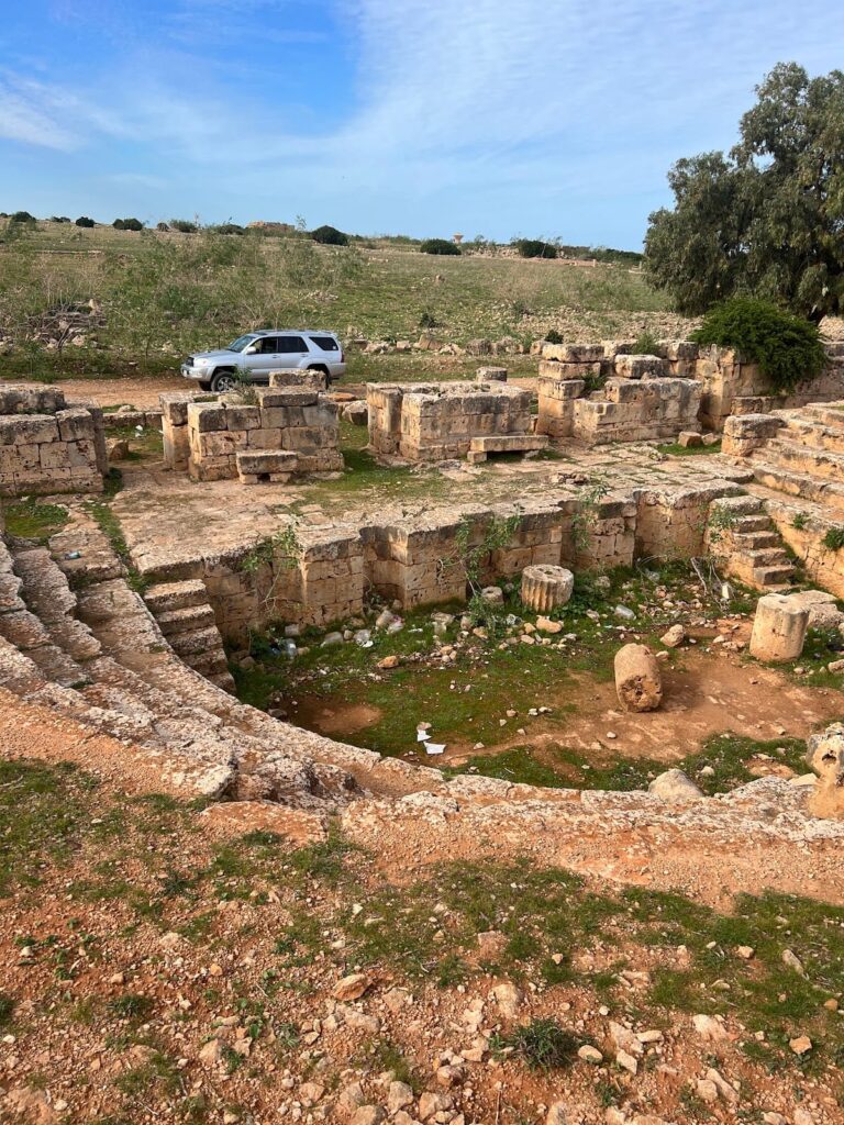
Ptolemais contained three theaters, including a small odeon. The smallest theater, the odeon, was adapted in the 4th or 5th century CE to hold water spectacles, a form of aquatic entertainment. This adaptation involved modifications to the stage and seating areas to accommodate water features. The other two theaters are larger but less well-preserved, with partial remains of seating and stage structures.
Square of the Cisterns
This Roman public water reservoir complex consists of seventeen vaulted cisterns located beneath the Square of the Cisterns. The cisterns have a combined capacity of approximately 7,000 kiloliters, making this the best-preserved water supply system in the Cyrenaica region. The vaulted construction and arrangement of the cisterns demonstrate advanced hydraulic engineering.
Aqueduct and Bridge
The city’s water supply depended on an aqueduct that carried spring water from about eight kilometers east. Remains of a bridge that carried both the aqueduct and a road across the Wadi Ziwanah survive outside the city walls. The bridge’s masonry and arches are partially preserved, illustrating the infrastructure supporting urban water needs.
Harbor and Lighthouse
The harbor was situated on the eastern side of the city, aligned with the main east-west avenue. An ancient lighthouse stood on a promontory near the harbor, beneath the present-day lighthouse. A 2009 underwater survey discovered a submerged pier and a shipwreck near the harbor, one of only three known on the Cyrenaican coast. These remains attest to the city’s maritime infrastructure and activity.
Royal Tomb or Mausoleum
A tower-tomb of Hellenistic date stands over 15 meters high, unique in the Cyrenaica region. Its architectural style is related to the Mausoleum at Halicarnassus and the tower tombs of Palmyra. It is possibly the burial site of Ptolemy VIII Physcon Euergetes II, who ruled Cyrenaica from 163 to 145 BCE. The mausoleum is surrounded by rock-cut tombs bearing inscriptions in multiple languages, reflecting the city’s ethnically diverse population, including Libyan, Greek, Roman, Jewish, and Christian communities.
Christian Basilicas
Two Christian basilicas dating to the 6th century CE have been identified within the city. These basilicas feature typical early Christian architectural elements such as a nave and aisles, apses, and baptisteries. Their remains include mosaic floors and structural foundations, attesting to the city’s role as a Christian bishopric during Late Antiquity.
Fortress of the Dux
A late antique building known as the “Fortress of the Dux” is present within the site. Although specific architectural details and dimensions are not fully documented, the structure is interpreted as a military or administrative building from the Byzantine period.
Italian Colonial Town and Fortifications
A small town built during the Italian occupation in the early 20th century exists near the ancient harbor. Several Italian military fortifications and small forts from this period remain in the surrounding area. These modern structures are distinct from the ancient archaeological remains but form part of the site’s historical stratigraphy.
Other Remains
Excavations have revealed pottery and metallurgical workshops functioning from the 4th to 6th centuries CE near the excavated insula. Large containers for agricultural products were found in domestic quarters, indicating storage and economic activity within residential complexes. Rock-cut tombs surround the city, some of which were later repurposed as quarries during the medieval period. Surface traces of large city blocks and insulae with well-preserved peristyle houses are visible. Remains of a submerged pier and shipwreck near the harbor, as well as the aqueduct bridge across Wadi Ziwanah, are also part of the site’s archaeological record.
Archaeological Discoveries
Excavations at Ptolemais have yielded a variety of artifacts spanning from the Hellenistic through the Byzantine periods. Numerous coins, including a hoard of 568 Roman coins discovered in 2006, cover issues from the 2nd and 3rd centuries CE and include sesterces, silver, and bronze denominations. Over 1,000 coins have been recovered and conserved, contributing to the study of Cyrenaican coinage and economic history.
Pottery finds include amphorae and tableware from local and imported sources, recovered primarily from domestic quarters and workshop areas. Inscriptions in Greek, Latin, and other languages have been found on tombs and public monuments, providing dedicatory and funerary information. Tools related to pottery production and metallurgy were uncovered in workshop contexts dating from the 4th to 6th centuries CE. Domestic objects such as lamps and cooking vessels have been found in residential areas, while religious artifacts including statuettes and altars were recovered from basilicas and other sacred spaces.
Preservation and Current Status
The ruins of Ptolemais vary in preservation. The city walls and major street layouts remain visible, though much of the masonry is fragmentary. The Square of the Cisterns is well-preserved, with intact vaulted cisterns. The Palazzo delle Colonne and the residential insula excavated by the Polish team retain substantial architectural elements, including mosaics and frescoes, which have undergone conservation. The amphitheatre, hippodrome, and theaters survive in partial form, with seating and structural remains fragmentary.
Conservation efforts by the Polish Institute of Archaeology and the Libyan Department of Antiquities have stabilized mosaics, paintings, coins, and sculptures. Some restoration has been undertaken, but many structures remain in situ without reconstruction. The site faces challenges from erosion, unauthorized digging, and proximity to modern and Italian-era settlements. The absence of a defined buffer zone complicates protection measures. Ongoing excavation and conservation continue under local and international cooperation.
Unexcavated Areas
Significant portions of the city within the defensive walls remain unexcavated. Surface surveys and remote sensing have identified additional insulae and urban blocks awaiting investigation. The full extent of the residential and public quarters is not yet fully documented. The harbor area and surrounding hinterland also contain potential archaeological deposits that have not been systematically explored.


