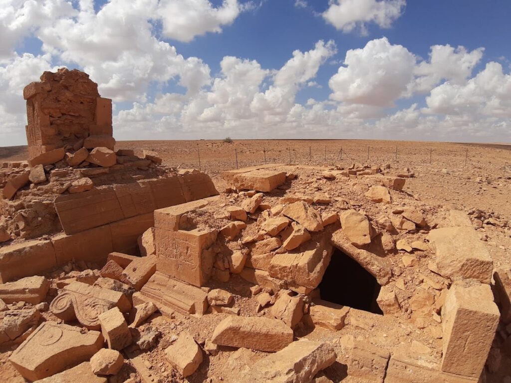
Gerisa (Ghirza): A Roman and Byzantine Frontier Settlement in Libya
Table of Contents
Visitor Information
Google Rating: 4.7
Popularity: Very Low
Google Maps: View on Google Maps
Country: Libya
Civilization: Roman
Remains: City
Context
Gerisa, also known as Ghirza, is situated within the Wadi Ghirza in the inland region of Tripolitania, Libya. The site occupies a semi-arid, pre-desert landscape characterized by seasonal wadis that channel episodic water flows and support limited groundwater near alluvial terraces. This hydrological setting enabled the development of water management systems, including dams and cisterns, which are documented through archaeological survey and excavation.
Archaeological evidence indicates that Gerisa was occupied primarily during the Roman and Byzantine periods, with rural farmsteads and funerary monuments dating mainly from the third to the seventh centuries CE. Material culture recovered at the site reflects a blend of Roman administrative influence and local Berber adaptation, illustrating cultural interaction on the empire’s southern frontier. Although occupation diminished after the seventh century, limited Early Islamic presence is attested. The site’s dry environment has contributed to the preservation of masonry structures, tomb façades, and hydraulic installations, despite some erosion and disturbance from looting and modern land use.
Systematic archaeological investigations have been conducted by Libyan authorities in collaboration with international scholars since the early twentieth century. These studies have produced detailed site plans, ceramic chronologies, and documentation of architectural and funerary features, providing a comprehensive framework for understanding Gerisa’s role within the broader context of Roman North Africa.
History
Gerisa (modern Ghirza) represents an example of a Roman frontier settlement located on the southern margin of the empire in Tripolitania’s arid interior. Its historical trajectory exemplifies the processes of Roman imperial expansion, military frontier consolidation, and local cultural integration in a challenging environment. Originating as a small Berber village, Gerisa evolved into a fortified agricultural town under Roman administration, maintaining occupation through the Byzantine period before its decline in the early Middle Ages amid regional transformations and the Arab conquests.
Roman Foundation and Early Imperial Period (1st century AD – early 3rd century AD)
During the early Roman Imperial era, Tripolitania was incorporated into the Roman provincial system, introducing new administrative and military frameworks. Gerisa initially existed as a modest Berber settlement prior to Roman influence. Archaeological and numismatic evidence dates the establishment of Gerisa to the first century AD, coinciding with the arrival of Roman merchants and soldiers who introduced Roman economic and cultural elements. The site’s strategic position near the confluence of the Wadi Zemzem and Wadi Ghirza placed it within a pre-desert zone approximately 250 kilometers southeast of the Libyan coast, serving as a frontier outpost linking desert and coastal regions.
Expansion under Septimius Severus and the Limes Tripolitanus Reorganization (circa 197–201 AD)
In the late second and early third centuries AD, the Roman Empire undertook significant military reforms to secure its southern frontier in Tripolitania, known as the Limes Tripolitanus. Under Emperor Septimius Severus, legatus Quintus Anicius Faustus, commanding Legio III Augusta, directed the construction of defensive forts including Garbia and Golaia between 197 and 201 AD. These fortifications curtailed nomadic incursions, stabilizing the region and enabling the expansion of settlements such as Gerisa.
Following these military improvements, Gerisa developed rapidly into a prosperous agricultural town. The settlement attracted veteran soldiers, many of whom were local Berbers or legionaries from Italy, who were granted land and settled as farmer-soldiers (Limitanei). Gerisa became integrated into a network of military and commercial outposts along the Limes Tripolitanus, facilitating both defense and trade between the desert interior and coastal provinces.
Urban and Agricultural Development (3rd–4th centuries AD)
By the third and fourth centuries AD, Gerisa had expanded into a substantial rural town comprising approximately forty buildings, including six fortified farm complexes known as centenaria. Two of these farms, Buildings 31 and 34, measured roughly 47 by 47 meters and 45 by 45 meters respectively, combining agricultural production with defensive architecture. Roman engineering interventions transformed the arid landscape through the construction of dams and cisterns in the Wadi Ghirza, regulating seasonal flash floods and enabling intensive cultivation.
The agricultural economy was diversified, producing cereals, olives, vines, figs, pulses, almonds, dates, and possibly melons. The population consisted of Romanized Berbers, veteran soldier-farmers, and local elites, reflecting a complex social fabric. A prominent temple at the settlement’s periphery, likely dedicated to the Berber semi-god Gurzil, indicates religious syncretism between Roman and indigenous beliefs during this period.
Funerary Practices and Social Structure (3rd–4th centuries AD)
Gerisa’s funerary landscape comprises two principal necropolises situated north and south of the settlement, each containing monumental mausolea constructed of ashlar masonry with temple-like colonnaded facades. These tombs exhibit a synthesis of Roman architectural forms and indigenous decorative motifs, including reliefs depicting agricultural cycles, hunting scenes on camel and foot, grapes, fish, and ostrich hunts. The southern necropolis is distinguished by numerous portrait busts and sculptural representations, whereas the northern necropolis emphasizes epigraphic inscriptions, suggesting the presence of at least two aristocratic families or clans competing for social prestige.
Funerary offerings such as altars, ritual bowls, and fragmented statues recovered from tombs and the temple underscore the importance of religious expression among the local elite. These practices reflect a cultural fusion of Roman funerary customs with Berber traditions, highlighting the community’s complex identity and social stratification during the third and fourth centuries.
Late Roman and Byzantine Period (Late 3rd century – 6th century AD)
Following the administrative and military reforms of Emperor Diocletian in the late third century, parts of the Limes Tripolitanus were partially abandoned, with frontier defense increasingly entrusted to Limitanei soldier-farmers who combined military and agricultural roles. Gerisa persisted as a frontier settlement under Byzantine rule, particularly after Emperor Justinian’s reorganization of the region’s defenses in 533 AD. Archaeological evidence attests to continued, albeit reduced, occupation through the fifth and sixth centuries, reflecting broader regional shifts and the gradual contraction of imperial authority.
During this period, Gerisa’s social and economic structures adapted to diminished imperial support, with local leadership assuming greater responsibility for defense and administration. While direct evidence of Christianization at Gerisa is limited, the broader region experienced ecclesiastical developments consistent with Byzantine influence.
Abandonment and Early Islamic Period (7th century AD onward)
The Arab conquests of the late seventh century precipitated the decline and eventual abandonment of Gerisa. Archaeological data indicate minimal Early Islamic reoccupation, lacking significant urban or economic revival. By the tenth century, the site was largely forgotten and buried beneath sand. Local oral traditions later interpreted the ruins as a city petrified by divine punishment.
Daily Life and Importance by Period
Roman Foundation and Early Imperial Period (1st century AD – early 3rd century AD)
During its initial phase, Gerisa was a small Berber village that gradually incorporated Roman cultural and economic elements following the arrival of Roman merchants and soldiers. The population was predominantly indigenous Berbers who increasingly adopted Roman personal names and customs, indicating early acculturation processes. Social organization likely combined local family structures with emerging Roman administrative roles.
Economic activities centered on subsistence agriculture, supported by the site’s proximity to seasonal wadis. Early inhabitants cultivated cereals and exploited wild resources, while trade with coastal and desert communities introduced Roman goods. Residential architecture consisted of modest stone-built dwellings adapted to the arid environment. Religious practices combined indigenous Berber beliefs with nascent Roman cults, though no monumental religious structures from this period survive.
Transport and communication relied on footpaths and animal caravans connecting Gerisa to coastal and desert routes. The settlement functioned as a modest frontier village within the Roman provincial network.
Expansion under Septimius Severus and the Limes Tripolitanus Reorganization (circa 197–201 AD)
The military reorganization of the Limes Tripolitanus under Septimius Severus transformed Gerisa into a fortified agricultural town. The population diversified as veteran soldiers, including local Berbers and Italian legionaries, settled as farmer-soldiers (Limitanei), combining military duties with agricultural production. This fostered a social hierarchy in which military veterans held land alongside local Berber families integrated into Roman administrative structures.
Agricultural output intensified, supported by imperial investment in water management infrastructure such as dams and cisterns. The economy expanded to include cereal cultivation and olive groves, producing surpluses for regional trade. Fortified farm complexes (centenaria) emerged as key economic units, combining defense with agricultural activity.
Trade goods included Roman pottery, metal tools, and textiles, transported via caravan routes secured by the military network.
Religious life began to exhibit syncretism, exemplified by the probable establishment of a temple dedicated to the Berber deity Gurzil, indicating the fusion of Roman and indigenous cults. Gerisa’s regional role expanded as a military-agricultural outpost integral to frontier defense and economic integration within Tripolitania.
Urban and Agricultural Development (3rd–4th centuries AD)
By the third and fourth centuries, Gerisa had matured into a substantial rural town with approximately forty buildings, including six large fortified farms. The population was culturally mixed, comprising Romanized Berbers, veteran soldier-farmers, and local elites organized around extended households managing agricultural estates. Social stratification is evident in funerary monuments and inscriptions referencing aristocratic families.
Agricultural production was intensive and diversified, with archaeological evidence for cereals, olives, vines, figs, pulses, almonds, dates, and possibly melons. Roman hydraulic engineering, including dams and cisterns, regulated seasonal floods, enabling reliable cultivation in the semi-desert environment. Production occurred primarily at the household and estate level, with surplus goods likely traded regionally.
Markets likely operated informally within the settlement or nearby military forts, facilitating exchange of agricultural produce and manufactured goods. Transport relied on animal caravans and footpaths linking Gerisa to coastal and desert networks.
Religious practices flourished around the temple to Gurzil and local cults, with funerary customs reflecting elite identity through monumental tombs adorned with agricultural and hunting iconography. Gerisa functioned as a key agricultural hub within the Limes Tripolitanus, supporting frontier defense and sustaining a complex rural economy.
Funerary Practices and Social Structure (3rd–4th centuries AD)
Gerisa’s funerary monuments reveal a socially stratified community with two main necropolises featuring monumental tombs that blend Roman and indigenous architectural and artistic traditions. Elite families commissioned mausolea with temple-like facades, colonnaded arcades, and richly decorated burial chambers, underscoring their wealth and status.
Portrait busts and inscriptions distinguish at least two aristocratic lineages, indicating competition for prestige and social dominance. Funerary iconography emphasizes agricultural cycles, hunting scenes, and local fauna, reflecting the community’s connection to land and identity. Funerary offerings and cultic artifacts suggest ongoing religious rituals honoring ancestors and deities.
These practices illustrate a fusion of Roman funerary customs with Berber traditions, highlighting the cultural syncretism characteristic of Gerisa’s elite. The necropolises also functioned as social markers reinforcing family lineage and community cohesion within the frontier settlement.
Late Roman and Byzantine Period (Late 3rd century – 6th century AD)
Following Diocletian’s reforms, Gerisa experienced a gradual decline in scale and prominence, with defense increasingly entrusted to local Limitanei soldier-farmers. The population contracted but maintained agricultural production and frontier duties. Social structures adapted to reduced imperial presence, emphasizing local leadership and military obligations.
Religious life evolved under Byzantine influence, with possible Christianization of the population, although direct evidence at Gerisa is limited. The settlement remained a minor frontier outpost within the Byzantine provincial system, retaining some military and agricultural functions despite regional instability.
Abandonment and Early Islamic Period (7th century AD onward)
The Arab conquests precipitated the near-total abandonment of Gerisa by the late seventh century.
Remains
Architectural Features
Gerisa encompasses an area approximately 500 meters northeast to southwest and 300 meters northwest to southeast, comprising around forty structures. These range from small single-room buildings to large fortified complexes. Construction predominantly employed local stone masonry combined with Roman building techniques, including finely cut ashlar blocks and mortar. The settlement’s layout reflects a rural town integrating residential, agricultural, military, and funerary architecture, arranged on alluvial terraces adjacent to seasonal wadis. Water management features are integrated into the landscape, demonstrating adaptation to the semi-arid environment.
Most extant structures date from the late second to fourth centuries CE, corresponding to the town’s expansion under Roman imperial reforms. Evidence of continued, though diminished, occupation extends into the Byzantine period (fifth to sixth centuries CE). Many buildings retain substantial walls and foundations, while architectural elements such as tomb façades and reservoir walls remain well preserved. Erosion and past looting have affected some areas, but key features survive in situ.
Key Buildings and Structures
Fortified Farms (Centenaria)
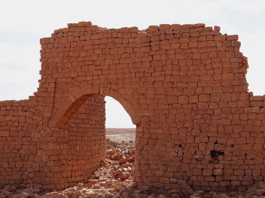
Six fortified farm complexes, known as centenaria, constitute a significant component of Gerisa’s remains. Constructed primarily in the third and fourth centuries CE, these complexes served combined agricultural and defensive functions. Two prominent examples, Buildings 34 and 31, measure approximately 45 by 45 meters and 47 by 47 meters respectively. The farms feature thick stone walls enclosing courtyards and multiple rooms, designed to protect inhabitants, livestock, and stored produce from raids. Their layouts include storage areas, living quarters, and defensive towers or bastions, reflecting the security concerns of a frontier environment.
Temple of Gurzil
The temple, likely erected in the third or fourth century CE, is situated at the settlement’s periphery. It is associated with the Berber semi-god Gurzil, after whom the town may be named. The structure combines Roman architectural elements with indigenous decorative motifs. Excavations have uncovered altars, fragmented statues, and ritual bowls, indicating active cultic use. The temple’s masonry comprises ashlar blocks and includes a modest sanctuary area. Its location and associated artifacts confirm its religious function within the community, illustrating syncretism between Roman and local religious traditions.
Northern Necropolis
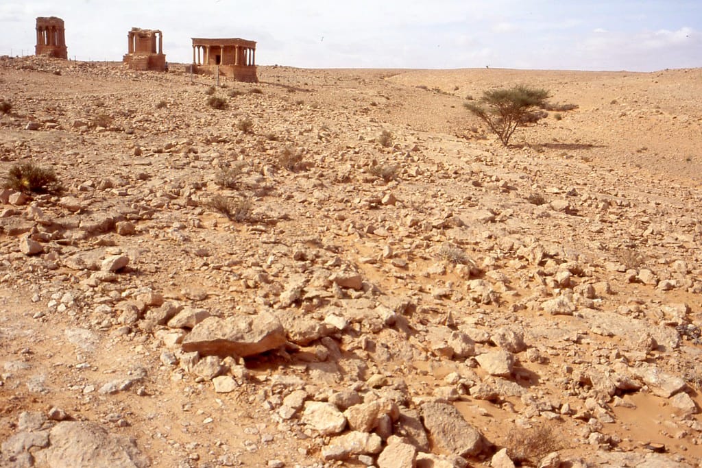
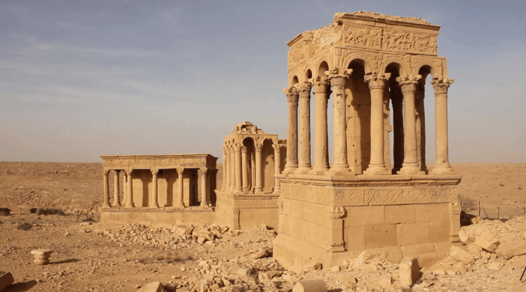
The Northern Necropolis contains three temple-shaped mausoleums, designated A, B, and C, constructed in the third and fourth centuries CE. These tombs overlook the settlement and share a consistent architectural design. Each mausoleum consists of a colonnaded arcade resembling a small temple façade, surrounding a masonry chamber with the burial vault beneath a raised podium. Decorations include reliefs depicting hunting and agricultural scenes, blending classical Roman and local artistic styles. This necropolis emphasizes inscriptions over portrait busts, suggesting a commemorative focus. Some monuments have uncertain functions but may relate to prominent local families or clans.
Southern Necropolis
The Southern Necropolis features mausoleums such as A and G, dating to the third and fourth centuries CE. These tombs often take the form of obelisks or tower-like structures. Unlike the Northern Necropolis, this area contains numerous busts and portrait sculptures integrated into the funerary monuments. The decoration includes vivid imagery of agricultural cycles, hunting scenes on camel or foot, grapes, fish, and ostrich hunts. The artistic style combines Roman naming conventions with indigenous decorative elements, reflecting the identity of the local aristocracy and their cultural affiliations.
Hydraulic Infrastructure
Gerisa’s water management system comprises dams and cisterns constructed in the Wadi Ghirza to regulate seasonal flash floods. These hydraulic works date primarily to the third and fourth centuries CE and demonstrate Roman engineering adapted to the arid environment. The dams control runoff, while cisterns store water for agricultural use. Many of these structures remain visible as stone masonry walls and basin outlines, providing tangible evidence of efforts to sustain farming in a semi-desert landscape.
Other Remains
Additional remains include smaller buildings such as one-room houses, workshops, and storage facilities scattered throughout the site, dating mainly from the third to fourth centuries CE. Defensive features linked to the Limes Tripolitanus frontier system, including walls and watchtowers, are present but less well preserved. Surface remains include architectural fragments, ashlar blocks, and decorative elements illustrating a blend of Roman and local construction techniques. The presence of two monumental burial grounds with richly decorated mausolea indicates a complex social structure, possibly involving at least two aristocratic families or clans.
Archaeological Discoveries
Excavations and surveys at Gerisa have yielded a diverse assemblage of artifacts spanning from the first century CE through the Byzantine period. Pottery includes locally produced tableware and imported amphorae, reflecting trade connections across the region. Numerous inscriptions, primarily funerary, provide Roman personal names and dedicatory formulas, often blending Latin with local linguistic elements. Coins recovered date from the reigns of emperors such as Septimius Severus and Justinian, corroborating occupation phases.
Tools related to agriculture and craft activities have been found within farm compounds and domestic areas. Domestic objects include lamps, cooking vessels, and personal items, illustrating aspects of daily life. Religious artifacts recovered from the Temple of Gurzil and funerary contexts include altars, statuettes, and ritual bowls, demonstrating the coexistence of Roman and indigenous religious practices. Most artifacts were discovered in situ during systematic excavations or surface surveys conducted by Libyan and international teams.
