Tipaza: A Multi-Period Archaeological Site on Algeria’s Mediterranean Coast
Table of Contents


Visitor Information
Google Rating: 4.4
Popularity: Low
Google Maps: View on Google Maps
Country: Algeria
Civilization: Byzantine, Phoenician, Roman
Remains: Burial, City, Civic, Domestic, Economic, Entertainment, Infrastructure, Military, Religious, Sanitation
Context
Tipaza is situated on the northern Mediterranean coast of Algeria, near the contemporary town of Tipaza, approximately 70 kilometers west of Algiers. The site occupies a coastal plain bordered by the Mediterranean Sea to the north and low-lying hills to the south, including the prominent Mount Chenoua. This topographical setting provided natural shelter and access to maritime routes, facilitating its role as a strategic harbor and waypoint along the western Mediterranean seaboard. The fertile surrounding plains supported agricultural activities, complementing the site’s maritime economy.
Established initially as a Phoenician trading post in the 6th century BCE, Tipaza evolved through successive cultural phases, including Punic, Roman, Byzantine, and early Islamic occupations. Its coastal position linked it to broader Mediterranean networks, influencing its development as a commercial and administrative center. Archaeological investigations, initiated in the early 20th century, have uncovered extensive remains spanning these periods, revealing complex urban planning and diverse architectural forms. Ongoing conservation efforts by Algerian heritage authorities aim to safeguard the site’s archaeological integrity and facilitate scholarly research into its multi-layered history.
History
Tipaza’s historical trajectory reflects its significance as a nexus of cultural and political influences along North Africa’s central Mediterranean coast. Originating as a Phoenician maritime outpost, it transitioned into a Carthaginian settlement before incorporation into the Roman provincial system. The city’s evolution mirrors broader regional dynamics, including Roman provincial reorganization, the spread of Christianity, Vandal and Byzantine rule, and eventual decline following the early Islamic conquests. Archaeological and epigraphic evidence documents its transformation from a trading station to a municipium and later a Roman colony with a notable Christian presence, before its abandonment in the 7th century CE.
Phoenician and Punic Foundation (6th–2nd century BCE)
Founded in the 6th century BCE, Tipaza began as a Phoenician trading post strategically located on a promontory near Mount Chenoua. This position enabled it to function as a maritime stopover between Icosium (modern Algiers) and Caesarea (Cherchell), facilitating navigation toward the western Mediterranean and the Pillars of Hercules. By the 2nd century BCE, the settlement had developed into a subordinate Carthaginian community, as attested by funerary steles bearing Punic iconography such as the Sign of Tanit and coins depicting horses and palm trees. The extensive necropolises from this period rank among the largest in the Punic world, reflecting diverse burial customs and interactions with indigenous Berber populations.
Adjacent to Tipaza, the Royal Mauritanian Mausoleum (Kbor er Roumia) exemplifies the syncretism of local basina architectural traditions with Hellenistic and Egyptian influences. This monumental circular funerary structure illustrates the cultural fusion characteristic of the region during the late Punic period, underscoring Tipaza’s role within the broader socio-political landscape of Mauretania.
Numidian Period (circa 2nd century BCE – early 1st century CE)
During the Numidian era, Tipaza was situated within the shifting political milieu of Mauretania, influenced by rulers such as Massinissa, Juba II, and Ptolemy. Although no major Numidian architectural remains survive due to subsequent Roman construction, archaeological finds—including Campanian ceramics, Hellenistic lamps, and coins bearing the images of Numidian kings—attest to continued occupation and cultural exchange. Under King Juba II, Tipaza flourished as a center of Greco-Roman culture and trade alongside the provincial capital Caesarea.
The execution of Ptolemy, son of Juba II, by Emperor Caligula in 40 CE precipitated the direct incorporation of Mauretania into the Roman Empire. This event marked a turning point, leading to administrative reorganization and the integration of Tipaza into the Roman provincial framework.
Roman Conquest and Administration (1st–2nd century CE)
Following the Roman annexation of Mauretania, Emperor Claudius divided the territory into Mauretania Caesariensis and Mauretania Tingitana around 42 CE, with Tipaza falling within the former province. In 46 CE, Tipaza was granted Latin Rights (ius Latii) and established as a municipium on a hill overlooking the sea. The urban core included a forum, judicial basilica, and capitol, all enclosed within city walls extending approximately 2,200 meters. The city expanded onto adjacent plains and hills, developing a complex urban fabric.
Subsequently elevated to the status of a Roman colony under the name Colonia Aelia Tipasensis, the city conferred full Roman citizenship to its inhabitants. By the late 2nd century CE, during the Antonine and Severan dynasties, the population is estimated at around 20,000 residents, known as Tipasitani. The city featured public buildings, private villas such as the Villa of the Frescoes, and advanced infrastructure including aqueducts and monumental fountains, reflecting its integration into Roman administrative and cultural systems.
Early Christian and Late Roman Period (3rd–5th century CE)
Christianity emerged in Tipaza by the early 3rd century CE, with the earliest dated African Christian inscription—the epitaph of Rasinia Secunda—dated to 237 CE. The 3rd and 4th centuries witnessed the construction of several basilicas, including the Great Basilica, the Basilica of Bishop Alexander, and the Basilica of Saint Salsa, indicating the growth of a significant Christian community. The Great Basilica, notable for its expansive nave and apse projecting over a cliff, incorporated annexes such as a baptistery and the bishop’s residence.
During the mid-4th century, Tipaza experienced religious tensions associated with the Donatist schism and resisted the siege by the rebel Firmus (371–372 CE). Funerary monuments from this period display Christian iconography, including symbols of resurrection and martyrdom. The cult of Saint Salsa developed around dedicated shrines, reflecting the city’s role as a religious center within the late Roman province.
Vandal, Byzantine, and Early Islamic Periods (5th–7th century CE)
The Vandal conquest in 430 CE resulted in the destruction of Tipaza and significant demographic decline. Under King Huneric, Christian persecution intensified, prompting many inhabitants to flee, often by sea to Spain. The Byzantine Empire reconquered the region in 534 CE, initiating restoration efforts and adapting existing structures. Despite these interventions, Tipaza’s prosperity diminished during the 6th century, challenged by environmental factors such as river sedimentation and advancing sand dunes.
The city was ultimately destroyed and abandoned following the Umayyad Arab conquest at the end of the 7th century CE, marking the cessation of its urban occupation and the transition to a post-urban landscape.
Modern Rediscovery and Conservation (19th century–present)
Rediscovered in the 19th century, Tipaza’s ruins were systematically excavated under French colonial administration, with Stéphane Gsell publishing a foundational monograph in 1894. Modern archaeological methods were introduced by Jean Baradez in 1946, who also established the first museum collections. The site is currently managed under Algerian cultural heritage legislation, including protective plans addressing conservation and presentation.
In 2002, Tipaza was inscribed as a UNESCO World Heritage Site, recognized for its exceptional testimony to Punic, Roman, early Christian, and Byzantine civilizations, as well as the cultural interactions between indigenous Berber populations and colonizing powers. The modern town of Tipaza, founded in 1857 near the ruins, serves as a center for heritage tourism and local cultural identity.
Daily Life and Importance by Period
Phoenician and Punic Foundation (6th–2nd century BCE)
During its initial phase, Tipaza’s population comprised Phoenician settlers and Carthaginian colonists alongside indigenous Berber groups. Funerary steles bearing the Sign of Tanit and Punic motifs indicate the presence of religious elites and skilled artisans. Social organization likely included merchant families controlling maritime trade, with Berber communities integrated through cultural exchange. Men predominantly engaged in seafaring and commerce, while women managed domestic and religious activities.
Economic life centered on maritime trade, with Tipaza serving as a coastal waypoint between Icosium and Caesarea. Extensive necropolises reflect investment in funerary customs and social stratification. Agriculture thrived on fertile plains, producing grains, olives, and fruits. Imported Punic ceramics and locally produced pottery suggest domestic use of decorated vessels. Clothing styles conformed to Mediterranean norms, adapted to the regional climate. Religious practices focused on Punic deities such as Tanit and Baal Hammon, evidenced by iconography and votive offerings.
Numidian Period (circa 2nd century BCE – early 1st century CE)
In the Numidian period, Tipaza’s population included indigenous Berbers and Hellenized elites under rulers like Juba II. Although monumental architecture from this era is absent due to later Roman construction, coins and pottery attest to active cultural and economic life. Social hierarchy encompassed royal administrators, local nobility, and artisans, with family structures reflecting Berber and Hellenistic traditions.
Agricultural activities intensified, particularly viticulture and olive cultivation, supporting local consumption and trade. Imported luxury goods such as Campanian pottery and Hellenistic lamps were consumed by wealthier households. Domestic architecture likely featured courtyards and decorated rooms, paralleling contemporary Numidian villas. Clothing incorporated Greco-Roman elements blended with indigenous styles. Trade networks connected Tipaza to Caesarea and Mediterranean markets, facilitating cultural and economic integration.
Roman Conquest and Administration (1st–2nd century CE)
Following Roman annexation and elevation to municipium and later colonia status, Tipaza’s population diversified to include Roman settlers, local Berbers, and Romanized elites. Epigraphic evidence records municipal magistrates such as duumviri and decurions, indicating structured local governance. Family life adhered to Roman patriarchal norms, with wealthy landowners residing in villas like the Villa of the Frescoes, while artisans and laborers occupied denser urban quarters.
The economy thrived on agriculture—grain, olives, and vineyards—augmented by maritime trade and artisanal production. Archaeological remains of a garum factory and workshops attest to industrial-scale manufacturing. The city’s water supply system, including an aqueduct and monumental fountains, supported urban life. Domestic interiors featured mosaic floors, frescoed walls, and columned courtyards, reflecting Roman aesthetic preferences. Religious life was initially polytheistic, with temples dedicated to Roman and local deities housed in the capitol. Tipaza functioned as a key administrative and commercial center within Mauretania Caesariensis.
Early Christian and Late Roman Period (3rd–5th century CE)
By the 3rd century CE, Tipaza hosted a significant Christian community alongside traditional pagan inhabitants. Christian inscriptions and basilica constructions indicate the emergence of an episcopal hierarchy, with bishops such as Alexander documented. Social roles expanded to include clergy and lay leaders, while family structures incorporated Christian values. The Donatist schism reflects religious tensions influencing civic life.
Economic activities continued agricultural production and trade, increasingly supporting ecclesiastical institutions. The Great Basilica complex, with its baptistery and bishop’s residence, served as a religious and social center. Domestic decoration maintained Roman traditions, with mosaics and frescoes depicting Christian symbols. Diet remained consistent with Mediterranean patterns, including cereals, olives, fish, and wine. Markets supplied both secular and religious needs, and transport infrastructure facilitated pilgrimages to martyr shrines such as that of Saint Salsa. Tipaza’s civic role shifted toward a religious center balancing municipal governance with ecclesiastical authority.
Vandal, Byzantine, and Early Islamic Periods (5th–7th century CE)
The Vandal conquest precipitated demographic decline and urban disruption, with many inhabitants fleeing persecution. Remaining residents included Christians under duress and possibly Berber groups. Byzantine reconquest restored partial stability, evidenced by architectural repairs and continued ecclesiastical presence. Social hierarchy became fragile, with diminished civic administration.
Economic activities contracted, focusing on subsistence agriculture and limited trade. Environmental challenges such as sedimentation and sand encroachment further hindered prosperity. Domestic life simplified, with fewer resources for elaborate decoration. Markets and transport persisted at reduced levels. Religious life remained predominantly Christian under Byzantine influence, with maintained churches and active bishoprics. The Arab conquest in the late 7th century led to the city’s destruction and abandonment, ending its urban function.
Remains
Architectural Features
Tipaza’s urban plan is defined by two principal streets: the decumanus maximus, oriented east-west and approximately 14 meters wide, paved with bossed stones; and the cardo, running north-south and descending toward the sea. The decumanus maximus connected the ancient cities of Icosium and Caesarea, underscoring Tipaza’s role within regional communication networks. The city was enclosed by defensive walls extending roughly 2,200 meters, constructed during the Roman period to encompass the expanded urban area.
Construction techniques include ashlar masonry and Roman concrete (opus caementicium), with vaulted structures supporting public buildings. The city expanded from its original hilltop location onto adjacent plains and hills, with fortifications enclosing the developed sectors. Visible remains today encompass public edifices, religious complexes, residential quarters, necropolises, and infrastructure such as aqueducts and sewer systems, reflecting a complex and multi-functional urban environment.
Key Buildings and Structures
Amphitheatre
The amphitheatre, constructed late in Tipaza’s history, measures approximately 80 meters in length and is oriented east-west. Excavations have revealed the northern section, including vaulted supports for seating tiers and high enclosing walls around the arena. The structure features two principal gates at the eastern and western ends, supplemented by three secondary gates on each lateral side. Its construction partially encroaches upon adjacent temple precincts, indicating a late urban addition.
Temple Anonyme (Anonymous Temple)
Located adjacent to the amphitheatre, this temple survives primarily as a podium and partial access staircase to the cella (inner chamber). It originally had three entrances opening onto a widened section of the decumanus maximus. No inscriptions or iconographic evidence have been found to identify the deity or cult associated with this temple. The remains are fragmentary and referenced in modern Algerian literature without detailed archaeological attribution.
New Temple
Opposite the anonymous temple across the forum square, the New Temple dates to the late 2nd to early 3rd century CE. It shares a similar architectural layout, including an entrance, courtyard, portico, and cella. The structure features regular paving and a better-preserved staircase. Later constructions partially obscure the original plan. The cultic function remains unidentified due to lack of dedicatory evidence.
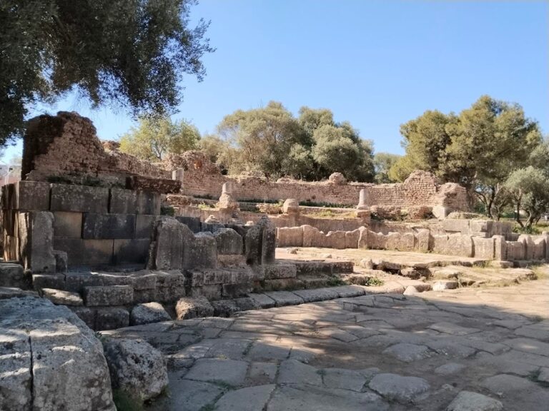
Basilica Judiciaire (Judicial Basilica)
Constructed in the late 1st to early 2nd century CE, the Judicial Basilica exhibits Hellenistic architectural influences. Excavated between 1914 and 1917, it comprises three naves separated by two rows of partially standing columns. The tribunal platform is shaped as a low apse oriented northeast, accessed by five steps resting on the decumanus paving, which narrows the street at this point. The basilica partially overlaps a monumental staircase leading upward to the forum.
Forum
The forum is situated above the Judicial Basilica and accessed via a monumental staircase passing over a vaulted cryptoporticus (covered corridor). It is a large paved esplanade measuring approximately 50 meters long by 25 meters wide. The northern side is dominated by the Capitole, of which only stair substructures and three adjoining cellae remain; these cellae housed the city’s three protective deities. The Curia, or council chamber, opens onto the northeast portico but survives only as indistinct ruins.
Villa des Fresques (Villa of the Frescoes)
This residential villa is named for the fragments of wall paintings discovered within. Its entrance includes a carriage gate and a pedestrian door opening onto the cardo portico. The vestibule leads to an interior courtyard (patio) surrounded on all four sides by a peristyle (columned walkway), with residential rooms arranged around it. The main room, the oecus (salon), aligns with the courtyard’s long axis and offers views of the patio and the sea beyond a terrace (solarium). The villa may have had an upper story, though this is not fully preserved.
Grande Basilique (Great Basilica)
Located on a promontory overlooking the Mediterranean Sea, the Great Basilica is the largest Christian building excavated in Algeria, measuring 58 by 42 meters. It originally featured a central nave over 13 meters wide, flanked by three collateral aisles on each side. Four arcades remain standing on the first collateral aisle on the left side. The apse projects over the cliff edge. To the north of the basilica are annex buildings including a chapel, baptistery, baths, and the bishop’s residence. Remains of a tower are located at the northwest corner of the city walls near the basilica. The structure is heavily degraded.
Mausolée Circulaire (Circular Mausoleum)
Situated in the western necropolis, the circular mausoleum is accessed via a postern gate near a tower and a cliffside path lined with scattered stone sarcophagi. The mausoleum is circular with niches between columns, each sheltering one or two sarcophagi. The central tomb is distinct and of particular importance. Additional sarcophagi lie within the sanctuary enclosure. Nearby cliff faces contain rock-cut hypogea comparable to Punic hanout tombs. Approximately 200 meters southwest lies the basilica of Saint Alexander, bishop of the city, adjacent to a martyr cemetery. This trapezoidal basilica features a western counter-apse and was built on rocky, uneven terrain. Excavated in 1892, nine sarcophagi at its apse form a platform once covered by a mosaic inscription now housed in the National Museum of Antiquities and Islamic Arts.
Theatre
The theatre, severely damaged in 1847 when its masonry was repurposed for a cholera hospital, was constructed entirely on flat ground, unlike many Roman theatres built on hillsides. Massive supporting pillars remain visible. The auditorium conformed to traditional Roman design and could seat between 3,000 and 4,000 spectators. Access was provided by underground passages opening in front of the stage and four external staircases leading to a mid-height gallery. Preserved elements include exterior vaults, the first three seating rows, a semi-circular orchestra separated from the stage by an indented brick wall designed to reduce echoes, and the stage pit with pillars supporting the stage floor. The stage wall itself has been destroyed.
Nymphée (Nymphaeum)
The nymphaeum is a semi-circular public fountain where water cascaded down steps between marble columns and basins into a collection basin. It is considered the most elaborate nymphaeum in North Africa. Remains include blue marble colonnades and polychrome marble cladding. The aqueduct supplying water to the city is still visible behind the nymphaeum.
Sainte Salsa Basilica and Hill
The hill of Sainte Salsa, located east of the ancient city, hosts a large Christian necropolis with tightly clustered sarcophagi around the basilica. The necropolis began in pagan times, evidenced by older tombs including a Punic cave tomb cut into the cliff (now collapsed), cup-shaped tombs, and columbaria for urns. The basilica dates to the late 5th century CE and is built against and opens onto the city walls. It is dedicated to martyrs Peter and Paul, as attested by a marble plaque in the museum. Excavations revealed anonymous sarcophagi and lamps decorated with resurrection symbols. Fourteen sarcophagi enclosed along the south wall likely form a martyrium. The basilica was initially square, 15 meters per side, with an east-facing entrance and west-oriented apse. Walls are constructed of cut stone. The interior includes a central nave 7.5 meters wide flanked by two aisles each 2.5 meters wide, separated by two rows of pillars with archivolts. A well-preserved tomb in the basilica center bears an epitaph for Fabia Salsa, likely an ancestor of Sainte Salsa. The central nave floor was covered with ornamental mosaics except over Fabia Salsa’s tomb. A commemorative inscription dedicated to Bishop Potenti is framed near the apse. In the first half of the 6th century, the basilica was enlarged to 30 meters long, with collateral aisles surmounted by galleries accessible via surviving staircases. To the north, a small door leads to martyrs’ graves sloping down to the cliff. A quadrangular chamber contains an agape table (“mensa”). To the south, the basilica is flanked by a funerary enclosure and a “fighters’ room.” Fabia Salsa’s tomb was later covered with a marble base surrounded by a grille and topped by a marble sarcophagus depicting the legend of Selene and Endymion. This sarcophagus is hypothesized to have contained Sainte Salsa’s relics due to its central location and violent destruction.
Great Baths (Grands Thermes)
Located east of the archaeological park in a former private garden now annexed to the park, the Great Baths cover a surface area comparable to the amphitheatre. Architectural elements such as columns, capitals, screens, lintels, amphorae, jars, and sarcophagi have been found. Large masonry blocks and high walls remain, with pillars rising up to nine meters above the frigidarium floor, which lies four meters below the current street level. Excavation is limited due to modern urban construction covering much of the baths.
Small Baths and Garum Factory
Near the residential area by the sea, remains include a building with a monumental staircase and small baths in good condition. Nearby are dolia (large vats) associated with a garum (fish sauce) production facility. Additional small baths and a Roman villa with mosaic traces are also present in this area.
Water and Sewer System
Excavations along the cardo have revealed the city’s water distribution and sewer system, demonstrating an organized urban infrastructure for sanitation and water supply.
Other Remains
The site contains extensive Punic necropolises dating from the 6th to 2nd centuries BCE, among the oldest and largest in the Punic world. The western necropolis includes a large cemetery with the circular mausoleum and various sarcophagi, some placed in niches and others scattered. Rock-cut hypogea near the mausoleum are comparable to Punic hanout tombs. The eastern hill (Sainte Salsa hill) hosts a large Christian necropolis with sarcophagi clustered around the basilica. Funerary practices across the site show multicultural influences from protohistoric through Roman and Christian periods.
The city walls and gates remain partially preserved. The original enclosure extends approximately 2,200 meters. A postern gate near a tower provides access to the western necropolis and mausoleum. The Capitole’s stair substructures and cellae remain on the forum’s northern side. The Curia survives only as indistinct ruins. Residential quarters near the seashore include villas and small baths. The theatre is located near the Caesarea gate on an elevation.
The Museum of Tipaza comprises a patio and a single exhibition room. The patio displays stelae, urns, pottery, a sculpture titled “L’enfant à l’amphore,” and a fountain. The exhibition room features the mosaic “Les Captifs” from the Judicial Basilica’s apse. The museum holds notable collections of glassware and pottery from Punic, Berber, and Roman periods, as well as sculptures and two finely carved white marble sarcophagi, one illustrating the legend of Pelops and Oenomaus.
Preservation and Current Status
The preservation of Tipaza’s ruins varies across the site. Structures such as the Great Basilica, amphitheatre, and forum retain substantial remains, though some are heavily degraded. The theatre is partially preserved, with key architectural elements visible despite damage. The mausoleum and necropolises maintain significant funerary monuments, while the city walls survive in sections. The Villa of the Frescoes preserves architectural features and wall painting fragments.
Restoration efforts have stabilized many structures, though some interventions involve modern materials. Excavations continue under Algerian heritage authorities, with conservation plans addressing threats from erosion, vegetation encroachment, and urban development. Certain areas remain stabilized but not fully restored to preserve archaeological integrity. The site benefits from UNESCO World Heritage designation since 2002, which supports its protection and scholarly study.