Timgad: A Roman Veteran Colony and Archaeological Site in Algeria
Table of Contents


Visitor Information
Google Rating: 4.6
Popularity: Low
Google Maps: View on Google Maps
Country: Algeria
Civilization: Byzantine, Roman
Remains: Burial, City, Civic, Domestic, Economic, Entertainment, Infrastructure, Military, Religious, Sanitation

Context
The Roman ruins of Timgad are situated in northeastern Algeria, near the contemporary town of Timgad, within the Aurès Mountains region. The site occupies a high plateau overlooking the Oued Abiod valley, providing a strategic vantage point over the surrounding plains. This elevated, relatively flat terrain was conducive to the implementation of a planned urban grid and facilitated access to fertile agricultural lands in the vicinity. Geographically, Timgad lies within the ancient Roman province of Numidia, an area characterized by a Mediterranean climate with diverse topographical features including mountains, valleys, and plains.
Founded circa 100 CE during Emperor Trajan’s reign, Timgad was established as a Roman colonia primarily for settling military veterans. The city remained continuously inhabited through the Roman Imperial period and into late antiquity, with archaeological evidence indicating a gradual decline in urban activity by the 7th century CE, coinciding with the early Islamic expansions in North Africa. The site’s abandonment appears to have been a protracted process rather than the result of sudden destruction.
Preservation of the ruins is notably high due to the arid climate and the absence of significant later construction over the site. Systematic archaeological investigations commenced in the early 20th century under French direction, revealing the city’s orthogonal street plan and monumental public architecture. Presently, Algerian heritage authorities oversee conservation efforts, recognizing Timgad as a key example of Roman urbanism in North Africa and an important resource for archaeological research.
History
Timgad’s historical trajectory exemplifies the Roman Empire’s strategies of territorial consolidation and cultural integration in North Africa. Founded as a veteran colony in the early 2nd century CE, the city developed into a well-organized urban center reflecting Roman civic and architectural ideals. Its history encompasses phases of imperial prosperity, religious transformation during late antiquity, political disruption following the Vandal and Berber incursions, Byzantine military reoccupation, and eventual abandonment in the early medieval period.
Foundation and Early Roman Period (c. 100–3rd century CE)
Established around 100 CE by Emperor Trajan, Timgad—originally Colonia Marciana Traiana Thamugadi—was founded as a Roman colonia to settle veterans of the Third Augustan Legion, under the legate Lucius Munatius Gallus. The colony conferred full Roman citizenship on its inhabitants, who were enrolled in the Papiria voting tribe. Strategically located approximately 21 kilometers from the military center of Lambèse, Timgad controlled key access routes to the Aurès Mountains and benefited from proximate water sources such as the Aïn Morris spring.
The city was constructed ex nihilo following a strict orthogonal grid plan centered on the cardo maximus (north-south axis) and decumanus maximus (east-west axis), embodying Roman urban planning principles modeled on military castra. Although no archaeological evidence confirms a preceding military camp, the layout reflects a design emphasizing order and control. Timgad represents the last Roman colony in North Africa founded with actual veteran settlers; subsequent colonies were honorary and did not involve new Roman inhabitants. Its foundation was part of a broader imperial policy aimed at regional Romanization and economic exploitation rather than a response to military threats, as the Aurès region was relatively peaceful at the time.
By the mid-2nd century, the city expanded beyond its original 12-hectare enclosure to cover over 90 hectares, with an estimated population of approximately 15,000 by the early 3rd century. The urban fabric included monumental public buildings such as a forum with colonnades, a basilica for judicial functions, a temple dedicated to Victory, and a large Capitolium constructed in the 2nd century and restored in the 4th. A theater with a seating capacity of around 3,500 and fourteen public baths attest to the city’s prosperity. Streets were paved with large limestone slabs, and residential blocks (insulae) were uniformly sized, often containing multiple dwellings.
Timgad’s municipal administration followed Roman civic models, featuring an ordo decurionum (city council) and magistrates including duumviri, aediles, and questors. Wealthy local elites, such as Plotius Faustus Sertius, engaged in euergetism by funding public amenities like markets, baths, and constructing luxurious private residences. The city’s economy was underpinned by agriculture in its hinterland, producing cereals, olives, and livestock. The Aqua Septimiana aqueduct supplied water to the urban center and its sanctuary complex, which included temples dedicated to deities such as Dea Patria (Goddess of Africa), Aesculapius, and Serapis.
Late Antiquity and Christianization (4th–5th centuries CE)
During the 4th and 5th centuries CE, Timgad underwent significant religious transformation as Christianity became firmly established. The city possessed its own bishopric by the mid-3rd century, with Bishop Novatus documented at the Council of Carthage in 256 CE. The Christian community was characterized by the coexistence of Catholic and Donatist factions, the latter a schismatic group prominent in Numidia. Both Catholic and Donatist bishops from Timgad participated in the Council of Carthage in 411 CE. The Donatist bishop Optatus led local resistance supported by militias until his arrest circa 398 CE.
Several large Christian basilicas, chapels, baptisteries, and a monastery were constructed primarily on the city’s periphery during this period. Artistic production included ceramics and metalwork bearing Christian iconography. Despite religious changes, Roman civic institutions persisted, and public works continued under emperors such as Antoninus Pius and Septimius Severus, including renovations of city gates, baths, and the temple dedicated to the imperial cult.
The social composition included Roman citizens, local Berber inhabitants, veterans, and slaves, with some indigenous Berbers integrated into the civic elite. However, the region experienced increasing political instability as the Western Roman Empire weakened, foreshadowing subsequent upheavals.
Vandal and Berber Period (5th–6th centuries CE)
Following the Vandal invasion of North Africa in 429 CE, Timgad endured attacks from local Berber tribes. Around 535 CE, the city was reportedly destroyed by Berber forces from the Aurès Mountains, as recorded by the historian Procopius. The city’s walls were dismantled, and inhabitants were deported to prevent reoccupation. Despite this destruction, archaeological evidence indicates that some agricultural activity and limited urban life persisted in a reduced capacity.
The Vandal kingdom imposed new landholding and taxation systems, affecting Romanized landowners but allowing some continuity among the local elite. The region witnessed the emergence of local Berber polities, such as the kingdom of Masties, who declared himself emperor in the late 5th century, reflecting the fragmentation of imperial authority in the area.
Byzantine Reconquest and Fortification (6th–7th centuries CE)
In the 530s CE, the Byzantine general Solomon reconquered the Aurès region, defeating Berber resistance and restoring imperial control. He undertook the reconstruction of Timgad, including the erection of a large fortress on the city’s southern edge around 539 CE. This fortress incorporated reused stones and inscriptions from earlier Roman monuments and comprised barracks, a chapel, baths, a water reservoir, and a courtyard, functioning as a military and administrative center.
Christian activity persisted under Byzantine rule, with relics consecrated in the region circa 581 CE and a chapel dedicated in Timgad by 645 CE. The city remained inhabited during this period but experienced gradual decline. The final abandonment likely occurred during or shortly after the early Islamic conquests of the 7th and 8th centuries, which transformed the political and religious landscape of North Africa.
Abandonment and Modern Rediscovery (8th century CE–present)
Following the early medieval period, Timgad was abandoned, with archaeological layers indicating a gradual reduction in occupation rather than sudden destruction. The arid climate and lack of subsequent construction preserved the ruins in a remarkable state. The site was first documented in modern times by British consul James Bruce in 1765, who recorded and sketched prominent monuments such as the triumphal arch and Capitolium. Further descriptions were made in the 19th century, notably by Robert Lambert Playfair in 1875, who recognized Timgad’s historical significance.
Systematic archaeological excavations began in the late 19th century under French colonial administration, revealing the city’s orthogonal grid, public buildings, baths, markets, and private residences. Conservation efforts have continued under Algerian authorities, and the site was designated a UNESCO World Heritage Site in 1982. Today, Timgad remains a key source for understanding Roman urbanism in North Africa and is accessible for scholarly study and heritage preservation.
Daily Life and Importance by Period
Foundation and Early Roman Period (c. 100–3rd century CE)
At its foundation, Timgad’s population consisted primarily of Roman military veterans from the Third Augustan Legion, supplemented by local Berber inhabitants. The social hierarchy was structured around Roman citizenship, with municipal magistrates such as duumviri and aediles overseeing civic administration. Wealthy landowners, including notable figures like Plotius Faustus Sertius, held significant influence and engaged in public benefaction. Artisans, slaves, and indigenous peoples were integrated into the urban fabric, with family units typically organized around multi-room insulae featuring courtyards and private baths.
The economy was predominantly agricultural, producing cereals, olives, and livestock, managed through a combination of imperial estates and private holdings. Small-scale workshops for ceramics, metalwork, and textiles likely operated within domestic or neighborhood contexts. The city’s orthogonal street grid facilitated commercial activity, with the forum, markets, and public baths serving as focal points for economic and social interaction. The Aqua Septimiana aqueduct provided a reliable water supply supporting domestic use and irrigation.
Dietary evidence suggests consumption of cereals, olives, fruits, fish, and locally produced wine and olive oil, consistent with Mediterranean patterns. Clothing comprised wool and linen tunics and cloaks, with sandals common across social strata. Domestic interiors were adorned with mosaic floors and painted walls, reflecting Roman aesthetic preferences and the wealth of elite households. Transportation relied on pedestrian movement, animal-drawn carts, and pack animals along well-paved streets connecting Timgad to regional centers such as Lambèse.
Religious life centered on Roman polytheism, with temples dedicated to Victory, Jupiter, and the imperial cult. Civic rituals and festivals reinforced Roman identity and social cohesion. The colonia status granted Timgad self-governance under Roman law, with a council of decurions managing local affairs. Educational and cultural activities likely included public readings and rhetorical instruction typical of Roman municipia, although direct evidence remains limited.
Late Antiquity and Christianization (4th–5th centuries CE)
By the 4th century, Timgad’s population had become increasingly Christianized, while maintaining a diverse ethnic composition including Roman citizens, Berbers, veterans, and slaves. The coexistence of Catholic and Donatist communities reflects religious plurality and occasional sectarian tensions, exemplified by bishops such as Novatus and Optatus. Family and social roles adapted to Christian norms, with ecclesiastical leaders gaining prominence alongside traditional civic officials.
Economic activities continued with agricultural production and artisanal crafts, though some decline in urban prosperity is suggested by fewer large-scale public projects. The construction of multiple Christian basilicas, baptisteries, and a monastery on the city’s outskirts indicates both religious devotion and a reorganization of urban space. Artistic output incorporated Christian iconography in ceramics and metalwork, signaling cultural transformation.
Diet and clothing remained broadly consistent with earlier periods, though Christian modesty may have influenced social customs. Domestic decoration included Christian symbols alongside traditional Roman motifs. Markets continued to supply local and imported goods, with trade routes still active but less intensively documented. Transportation modes remained similar, facilitating movement within the region.
Religious practices centered on Christian worship, including liturgies, baptisms, and feast days supplanting earlier pagan rites. Educational activities likely involved catechetical instruction and scriptural study within church communities. The city retained its municipal government structure, with magistrates and councils operating alongside the growing influence of bishops. Timgad evolved into a regional ecclesiastical center amid the declining Western Roman Empire.
Vandal and Berber Period (5th–6th centuries CE)
Following the Vandal conquest and subsequent Berber incursions, Timgad’s population diminished and urban life contracted. The destruction of city walls and deportation of inhabitants around 535 CE led to a reduced, more ruralized community with some continuity of agricultural activity. Ethnic composition likely shifted toward a greater Berber presence, with remnants of Romanized elites adapting to new political realities.
Economic activities focused on subsistence farming, with fewer workshops and diminished market functions. The Vandal administration imposed new taxation and landholding patterns, affecting local landowners but allowing some social continuity. Domestic life became simpler, with less evidence of elaborate decoration or luxury goods.
Diet remained based on local agricultural products, though trade networks were disrupted. Clothing likely became more utilitarian, reflecting economic hardship and changing cultural influences. Transportation was limited to essential local movement, as security concerns and political instability curtailed wider travel.
Religious life persisted in Christian forms, though the Donatist schism and Vandal Arianism introduced religious tensions. Civic structures weakened, with diminished municipal authority and increased local tribal governance. Timgad’s regional importance declined, transitioning from a thriving colonia to a marginal settlement within a fragmented political landscape.
Byzantine Reconquest and Fortification (6th–7th centuries CE)
The Byzantine reconquest under General Solomon revitalized Timgad as a fortified military and administrative center, evidenced by the construction of a large fortress incorporating reused Roman materials. The population included Byzantine soldiers, local Berbers, and remaining Romanized inhabitants, with Christian clergy maintaining religious institutions. Family and social structures adapted to a militarized environment emphasizing defense and imperial control.
Economic life oriented toward supporting the garrison and local agriculture, with limited artisanal production. The fortress complex featured baths and water reservoirs, indicating continued attention to hygiene and comfort. Civilian urban functions persisted but on a reduced scale compared to the Roman peak.
Diet and clothing reflected Byzantine military and local traditions, combining Mediterranean staples with practical garments suited to frontier life. Transportation involved military roads and pack animals facilitating troop movements and supply lines.
Christian worship flourished under Byzantine orthodoxy, with chapels and relic veneration documented into the mid-7th century. Educational activities likely included clerical instruction and liturgical training. Civic governance was subordinated to military authority, with the fortress commander exercising administrative control. Timgad’s role shifted to a strategic outpost within the Byzantine province, maintaining imperial presence in a contested region.
Abandonment and Modern Rediscovery (8th century CE–present)
Following the early Islamic conquests, Timgad experienced a gradual decline in population and urban functions, leading to abandonment by the 8th century. Remaining inhabitants likely relocated to more secure or economically viable settlements nearby. Daily life ceased to be urban in character, with the site reverting to ruins preserved by the arid climate.
No significant evidence of continued occupation or economic activity survives from this period. The loss of civic and religious institutions marked the end of Timgad’s role as a regional center. Subsequent centuries saw the site forgotten until its modern rediscovery.
The archaeological record from later periods is limited to material culture left in situ, without indications of resumed domestic life, trade, or governance. The site’s importance transitioned from a living community to a valuable historical and cultural monument studied by scholars and preserved by heritage authorities.
Remains
Architectural Features
Timgad’s urban fabric is defined by a rigorously planned orthogonal grid characteristic of Roman military colonies, established circa 100 CE. The original city was enclosed by a square stone wall with four gates, constructed in the early 2nd century CE. By the mid-2nd century, the city expanded beyond these fortifications, incorporating new residential quarters and public buildings. Streets were paved with large rectangular limestone slabs, intersecting at the forum, the city’s central public space. The urban area grew from approximately 12 hectares initially to over 60 hectares with the addition of the Byzantine fortress in the 6th century.
Construction techniques include ashlar masonry for walls and monumental structures, rubble masonry faced with cut stones for buildings such as the theatre, and extensive use of marble and mosaics for decorative purposes. The city’s architecture encompasses civic, religious, residential, and military buildings, reflecting its multifaceted urban character. The arid climate and abandonment have preserved many structures in varying states of completeness, ranging from well-preserved walls and arches to fragmentary foundations.
Key Buildings and Structures
City Walls and Gates
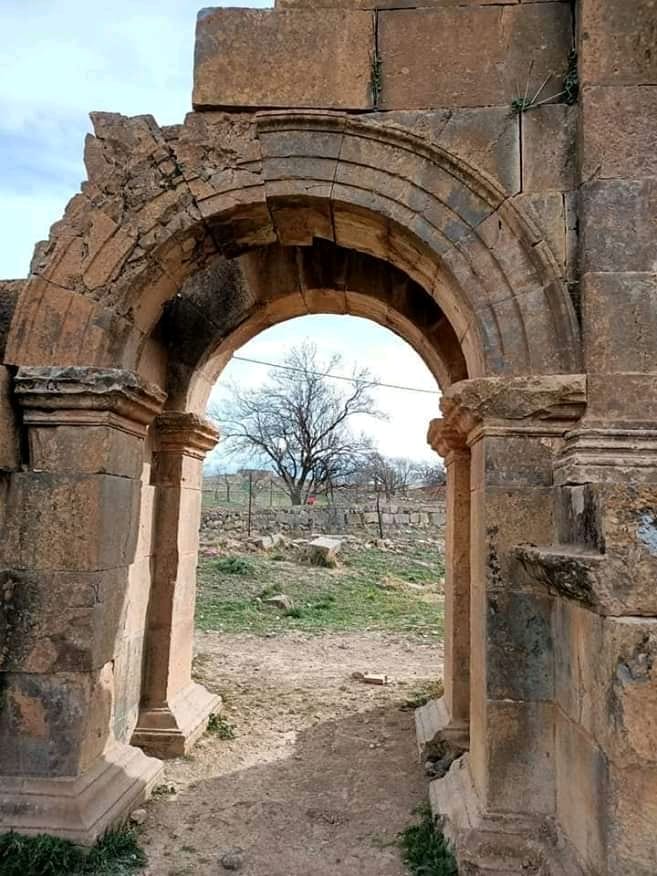
The original city walls, dating to the early 2nd century CE, formed a square enclosure typical of Roman veteran colonies. Constructed entirely of stone, these walls underwent multiple restorations during the Roman Imperial period. The western gate was transformed into the Arch of Trajan in the late 2nd century CE, featuring a large central bay for vehicular traffic flanked by two smaller pedestrian bays, all framed by Corinthian columns and vaulted arches. The arch retains decorative niches and reliefs added under Emperor Septimius Severus (193–211 CE). The northern gate, located at the terminus of the Cardo Maximus, preserves its piers though the arch itself is lost; it once bore an inscription honoring Emperor Antoninus Pius (dated 149 CE). Expansion beyond the original walls occurred by the mid-2nd century, with new neighborhoods and public buildings constructed outside the ramparts.
Forum
The forum, constructed in the early 2nd century CE, is a rectangular plaza surrounded on all sides by colonnades. It served as the political and social heart of the city, containing the curia (council chamber), basilica, and a small temple likely dedicated to Victory. The curia, built circa 116–117 CE, is rectangular with three doorways and a marble-clad interior, featuring a raised platform with movable seats and a preceding portico. Opposite the curia, the basilica comprises a large hall with a northern apse and a raised tribunal for judicial proceedings. The temple near the western side of the forum is tetrastyle (four columns on the façade) and raised on a podium. The forum was adorned with at least thirty statues bearing inscriptions naming deities, emperors, and local magistrates. The Capitolium, housing the Roman triad, was constructed separately outside the original walls and is not integrated into the forum’s layout.
Theatre
Situated south of the forum on the northern flank of a hillside, the theatre was built in the 2nd century CE. It features a semicircular seating area (cavea) approximately 63 meters in diameter, capable of accommodating around 3,500 spectators. The structure employs solid rubble masonry faced with large cut stones. The northern section rests on arches rather than being carved into the hill. A semicircular colonnade crowns the theatre, behind which archaeologists uncovered remains of a contemporaneous temple. Inscriptions on the theatre’s doors commemorate local patrons and emperors such as Antoninus Pius and Septimius Severus. No permanent amphitheatre has been identified at the site.
Temple of Cérès
Located near the theatre, this temple was restored between 139 and 161 CE. The restoration was financed by the ordo augustalium, a college of imperial cult priests, using their own treasury rather than municipal funds. The temple’s architectural details conform to classical imperial cult designs, though only partial remains survive.
Library of Rogatianus
Identified in 1906 through an inscription, the library dates to the late 3rd century CE. Positioned along the Cardo Maximus, it consists of a semicircular hall with niches for scrolls separated by columns, accompanied by six adjoining rooms. A statue of Minerva stood centrally within the semicircular hall. The library was funded by a bequest from the senator Marcus Iulius Quintianus Flavius Rogatianus, with an estimated capacity ranging from 16,000 to 28,000 volumes. The extant remains include foundations and partial wall structures.
Temple of the Genius of the Colony
Constructed circa 169 CE during the city’s western expansion, this temple precinct is trapezoidal, measuring approximately 32 by 12 meters and enclosed by a wall. Three sides are surrounded by a portico with seventeen columns. The temple’s cella measures 12.5 by 7.5 meters and features a Corinthian tetrastyle façade with a staircase of sixteen steps. The temple was funded by Marcus Publicius Candidus and his brother Caius Publicius Veranus. The dedication inscription associates the temple with a legate of the 3rd Augustan Legion, whose name was later erased due to damnatio memoriae.
Capitolium
Built in the 2nd century CE and restored in the 4th century, the Capitolium is located outside the original city walls in a prominent position visible from the road to Lambèse. It housed the Roman triad of Jupiter, Juno, and Minerva. The Capitolium’s plaza, larger than the forum, is surrounded by porticoes and functioned as a secondary forum. Restoration of the porticoes occurred between 364 and 367 CE, funded by Aelius Iulianus, a Christian city curator. The building’s remains include substantial stone walls, columns, and portions of the porticoes.
Arch of Trajan
Dating from the late 2nd century CE, the Arch of Trajan stands at the western entrance of the Decumanus Maximus. It features a large central bay approximately six meters high for vehicular traffic and two smaller pedestrian bays about 3.75 meters high. Niches above the pedestrian bays once held statues framed by Corinthian columns and vaulted arches. Each main face is adorned with four columns on pedestals. The arch was crowned by a sculptural group, likely a chariot. Reliefs depicting Mars and the goddess Concordia were added under Septimius Severus. The arch is well preserved, with deep ruts visible on the paving stones from ancient traffic.
Market of Sertius
Constructed during the Severan period in the city’s western expansion, the Market of Sertius is an oblong plaza bordered by porticoes and terminating in an apse. It includes a large exedra opening onto a courtyard and facilities for merchant stalls. The market was funded by Plotius Faustus Sertius and his wife and is connected to nearby baths. The remains include foundations, column bases, and portions of the porticoes.
House of Plotius Faustus Sertius
This large private residence, dating to the Severan period, is located along the former city wall line in the western quarter. It has a rectangular plan measuring 62 by 36.5 meters, covering approximately 2,263 square meters. The main entrance faces the Cardo Maximus and was possibly tripartite, preceded by a small portico. The house includes a vestibule with a central colonnade, two peristyles (courtyards surrounded by columns), reception rooms (triclinia), and a fishpond (vivarium) with two superimposed reservoirs. Private baths near the entrance feature a frigidarium of 35 square meters and four heated rooms totaling about 150 square meters. Statues of Asclepius and Hygieia were placed in the baths. The baths had separate street access, allowing use by guests or neighbors. Shops attached to the house likely served as rental properties.
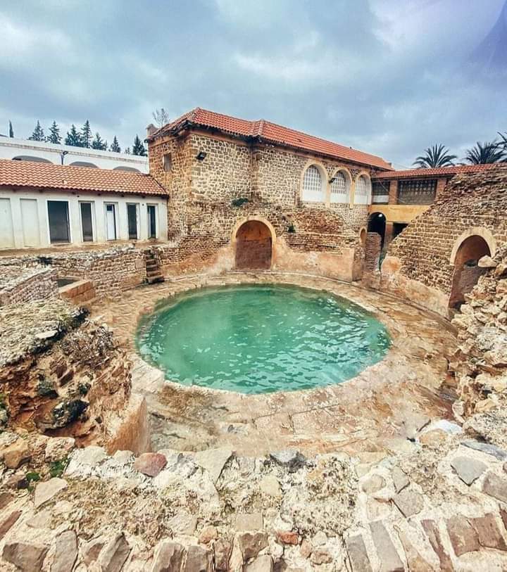
Temple of the Dea Patria and Aqua Septimiana Felix Sanctuary
Located approximately 300 meters south of the city along a north-south axis, this sanctuary complex is the largest religious building in Roman Africa, covering over 150 meters in length and 44 meters in width. It includes a large marble-lined pool measuring 27 by 7 meters, surrounded by bronze balustrades. Three small temples stand on a terrace overlooking the pool: the central and largest dedicated to Dea Patria (Goddess of Africa), identifiable by an elephant skin headdress; a western temple dedicated to Asclepius; and an eastern temple likely dedicated to Serapis, based on cult objects found. The sanctuary was richly decorated with white and green marble and mosaics. Porticoes (viridarium) surrounded the sanctuary, leading to a large paved plaza connecting to the city and southern baths. The sanctuary was built in the 2nd century and refurbished under the Severan dynasty around 213 CE. The site was later covered by the Byzantine fortress.
Public Baths
Timgad contained at least fourteen public baths of varying sizes, many with preserved mosaics. The largest include the Grand Thermes Nord (Northern Great Baths), with a symmetrical plan and a frigidarium covering 400 square meters, likely dating to the Severan period. The Thermes des Philadelphes, medium-sized baths in the suburbs, were built after the late 2nd century. The Grand Thermes Sud (Southern Great Baths), approximately 1,800 square meters, lie outside the original walls; they were enlarged in 198 CE and renovated during the Late Empire. Other baths include the Thermes du Capitole (~500 square meters), Thermes du Marché de Sertius (~1,000 square meters), and several smaller neighborhood baths ranging from 500 to 650 square meters. Baths were supplied by the Aqua Septimiana aqueduct and decorated with geometric mosaics and occasional figurative panels depicting deities such as Neptune and Jupiter. Public baths remained in use into the 5th century. Private baths also existed in large houses, including the House of Sertius. Late antique baths associated with the Donatist cathedral and the Byzantine fortress cover about 200 square meters.
Individual Houses and Residential Areas
The city’s original plan divided the urban area into 132 insulae (blocks) of about 400 square meters each. Most houses conform to this parceling, with two to four houses per insula. Large aristocratic houses are mostly located outside the original city limits, especially in the western expansion and northern suburbs. The House of Plotius Faustus Sertius and the House of the Hermaphrodite each cover about 2,200 square meters, while a large northern house near the Philadelphes baths covers approximately 2,500 square meters. Houses typically include vestibules, one or two peristyles, triclinia (dining rooms), and private baths. The House of Sertius notably includes a fishpond and baths with statues of health deities. The House of the Planters (Maison aux Jardinières), near the forum, features a peristyle decorated with plants and an annexed latrine. Mosaic decoration varies by neighborhood, with the area between the forum and the Mascula gate richly adorned, while the western Decumanus is less decorated. The northeastern quarter is less decorated and associated with textile production.
Christian Buildings
Christian structures are primarily located on the city’s periphery, often near necropolises. The largest complex is the Basilica of the West, measuring 23 by 63 meters, with three naves and an apse. The basilica includes an atrium with Corinthian columns, possibly reused from earlier buildings. Attached to the basilica is a baptistery with a well-preserved basin and polychrome mosaics. A chapel annex approximately 26 meters long adjoins the basilica. Other large basilicas with baptisteries have been identified, though their Donatist or Catholic affiliation remains uncertain. Smaller chapels, oratories, and monastic buildings have been found, some constructed with reused materials. The Byzantine fortress includes its own chapel. Christian funerary practices show continuity with earlier rites, evidenced by sarcophagi and libation installations.
Necropolises
Timgad was surrounded by necropolises located outside the city walls, in accordance with Roman law. The necropolis near the Lambèse gate is well studied, situated about 150 meters from the gate and 500 meters from the Arch of Trajan. Tombs are predominantly cremation burials, with epitaphs grouping family members. Tombs vary in richness, reflecting social status or family branches. Funerary offerings were common, often placed on plates or poured into tombs. Banquets associated with funerary rites continued into the Christian period despite ecclesiastical opposition.
Byzantine Fortress
Constructed in 539 CE by the patrician Solomon during the Byzantine reconquest, the fortress lies approximately 250 meters south of the city on the site of the Aqua Septimiana sanctuary. It has a rectangular plan tending towards trapezoidal, with a perimeter measuring about 120 by 80 meters. Walls survive up to 14 meters high and are reinforced by eight towers, including a central northern gate tower. The fortress was built using numerous reused Roman inscriptions and blocks. The eastern part housed barracks, while the western part contained common facilities: a water reservoir converted from the sanctuary pool, a chapel, and baths covering about 200 square meters opening onto the courtyard. The fortress also includes a headquarters building between the baths and chapel and a courtyard of honor.
Preservation and Current Status
The ruins of Timgad are generally well preserved due to abandonment and the arid climate, which limited later construction and erosion. The Arch of Trajan, city walls, and gates remain largely intact, though some arches and decorative elements are fragmentary. The forum’s colonnades and major buildings survive in partial form, with foundations and wall segments visible. The theatre’s seating area and structural elements are preserved, though some parts have collapsed. The Capitolium and temples retain substantial masonry and architectural details. Public baths and private houses show varying degrees of preservation, with mosaics and structural remains extant.
The Byzantine fortress walls survive up to 14 meters in height, with towers and internal structures partially preserved. Christian buildings and necropolises are fragmentary but identifiable. Conservation efforts have stabilized many structures, though some areas remain vulnerable to visitor pressure, vandalism, and environmental factors. Restoration interventions have been undertaken, primarily using original materials, but some reconstructions employ modern techniques. The site is managed by Algerian heritage authorities, with ongoing preservation challenges due to limited specialized personnel.