Itanos: An Ancient Coastal City in Crete
Table of Contents
Visitor Information
Google Rating: 4.6
Popularity: Low
Google Maps: View on Google Maps
Country: Greece
Civilization: Byzantine, Greek, Roman
Remains: City
Context
Ancient Itanos is situated on the northeastern coast of Crete, near the modern town of Sitia in the regional unit of Lasithi, Greece. The archaeological site occupies a coastal headland flanked by Itanos Bay and an adjacent low-lying plain, providing a interface between maritime access and fertile hinterlands. This geographic setting offered natural advantages for settlement, combining proximity to the sea with arable land suitable for agriculture and resource exploitation.
Archaeological evidence from the site reveals a long sequence of human activity beginning in the Late Bronze Age and continuing through the Iron Age. Urban development is most visible from the Archaic and Classical periods onward, with occupation persisting into the Hellenistic and Roman eras. Byzantine-era material culture, including pottery and reused architectural elements, attests to continued, though diminished, habitation. The site’s landscape preserves extensive surface remains and funerary areas, reflecting its historical complexity within the broader eastern Cretan region.
European travelers first documented the ruins in the nineteenth century, initiating systematic archaeological interest. Since the mid-twentieth century, Greek and international teams have conducted targeted excavations and comprehensive surveys, employing modern methods such as aerial photography and GPS mapping.
History
Ancient Itanos represents a significant example of a coastal Cretan settlement with a continuous occupation spanning from the Final Neolithic through the Byzantine period. Its historical trajectory reflects broader regional dynamics, including shifts in political control, economic networks, and religious transformations. The city’s development from a modest Bronze Age presence to a prominent Classical and Hellenistic polis, followed by integration into the Roman provincial system and eventual Christianization, illustrates the complex cultural layering characteristic of eastern Crete.
Final Neolithic and Bronze Age
The Itanos promontory and its environs exhibit evidence of human activity beginning in the Final Neolithic period, with at least 55 identified sites dating to the Bronze Age and Final Neolithic scattered across the landscape. Despite this extensive prehistoric presence, the future urban site of Itanos itself lacks direct Minoan material culture. Instead, Minoan settlements, agricultural installations, dams, and lookout points were concentrated near the nearby villa of Vai, several kilometers to the west.
The catastrophic eruption of the Santorini volcano and the associated tsunami during the Late Minoan period severely disrupted local communities, contributing to the decline of settlements such as Vai by Late Minoan III. Subsequently, the immediate area around Itanos experienced a marked reduction in habitation during the Early Iron Age, with the site remaining largely unoccupied until the Geometric period.
Geometric, Archaic, and Classical Periods
Itanos was reestablished as a coastal urban center during the Geometric period in the 8th century BCE, marking the foundation of the classical city near the shore. The city is first attested in historical sources by Herodotus, who recounts that Corobius, a purple dye merchant from Itanos, assisted the Theraeans in founding Cyrene by providing knowledge of the Libyan coast. Byzantine lexicographers attribute the city’s foundation to a mythological figure named Itanos, son of Phoenix, or alternatively to a bastard son of the Kouretes, legendary protectors of Crete. Archaeological and numismatic evidence confirms that Itanos minted its own coinage during this period, some coins depicting a female figure with a fish tail, reflecting distinctive local iconography and cultural symbolism. Throughout the Classical era, Itanos functioned as an autonomous city-state, actively engaged in regional trade and political affairs within eastern Crete.
Hellenistic Period
The Hellenistic era witnessed the territorial and political expansion of Itanos, which emerged as one of the most influential cities on Crete. The city’s domain extended from Cape Sidero in the north to Cape Goudouras in the southeast, encompassing approximately 130 square kilometers. Itanos continued to issue its own currency and invested in significant religious architecture, erecting temples dedicated to deities such as Asclepius, Athena, Tyche, and Zeus. The city maintained competitive relations with neighboring centers including Praesus and Ierapetra (ancient Hierapytna). A Greek inscription preserved at Toplou Monastery records a Roman Senate decision adjudicating territorial disputes involving Itanos, Praisos, and Hierapytna, underscoring the city’s political relevance during this period. Additionally, Itanos was for a time a protectorate under Ptolemaic Egypt, reflecting its strategic and economic importance within the eastern Mediterranean geopolitical landscape.
Roman Period and Christianization
Following Crete’s incorporation into the Roman Empire in the 1st century BCE, Itanos became part of the imperial provincial administration. The city adapted to Roman governance structures while maintaining local civic institutions, as evidenced by inscriptions referencing magistrates and councils. During Late Antiquity, Christianization transformed the urban fabric, with the construction of basilicas and other ecclesiastical buildings signaling the spread of Christianity. Despite these developments, Itanos was abandoned in the 7th century CE, concluding approximately fourteen centuries of continuous occupation.
Archaeological Rediscovery and Research
The ruins of Itanos were first systematically recorded in the 19th century by European travelers. In 1852, Captain Thomas Abel Brimage Spratt conducted a survey, mapping ruins, inscriptions, tombs, and churches, and referring to the site as Eremoupolis, or “desert city.” Between 1884 and 1887, Italian archaeologist Federico Halbherr undertook systematic surveys and epigraphic studies, definitively identifying the site as ancient Itanos through inscriptions naming the city and its inhabitants. French excavations led by J. Demargne in 1899–1900 focused on early Christian basilicas and inscriptions, though publication was delayed.
Mid-20th century investigations by the French School of Archaeology sought Minoan remains but found none at the city site itself. From 1994 to 2005, collaborative surveys by the Greek 24th Ephorate, the French School at Athens, and the Institute of Mediterranean Studies employed aerial photography, GPS mapping, and surface survey over approximately 20 square kilometers, producing a comprehensive archaeological database. These efforts have refined the understanding of Itanos’ long occupation and cultural phases. The site is currently protected under Greek antiquities law and incorporated within Natura 2000 and the Sitia Geopark.
Remains
Architectural Features
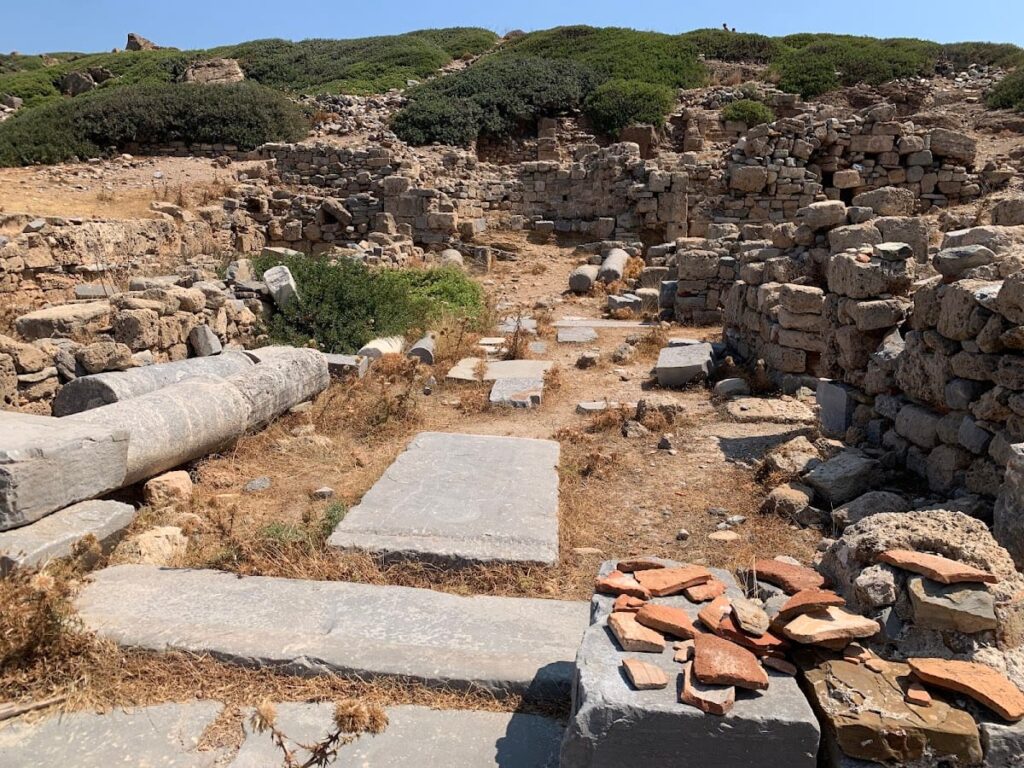
The archaeological remains of Ancient Itanos are distributed across a coastal headland and an adjoining low plain, structured around two prominent hills known as the east and west akropoleis. The east akropolis, located on the headland between Itanos Beach and Eremoupolis Beach, represents the highest point within the city’s topography. However, it lacks sufficient elevation or isolation to function as a defensible fortress. Surface remains on the east akropolis include scattered wall fragments and pottery spanning from the Protogeometric period (circa 10th century BCE) through the Hellenistic era (3rd–1st centuries BCE). This area has suffered significant damage, limiting the preservation of architectural features.
City walls are visible primarily to the south of the site, first noted by 19th-century explorers such as Captain Spratt. These fortifications are fragmentary but delineate a defensive perimeter enclosing the urban core. Although precise dating and construction techniques remain partially unresolved, the walls likely date to the Classical or Hellenistic periods, corresponding with phases of urban expansion.
The habitation quarter occupies the lower ground between the two akropoleis and served as the principal residential and urban zone. This area is heavily overlain by Christian-era constructions, complicating stratigraphic analysis. Surviving remains include foundations and wall fragments of domestic and public buildings, reflecting continuous occupation from the Geometric period through the Byzantine era (up to the 7th century CE).
Key Buildings and Structures
Necropolis (Cemetery)
The necropolis is situated on a hill north of the city and contains numerous tombs and funerary monuments, many bearing inscriptions referencing Itanos and its citizens. Excavations conducted in the late 19th century and briefly in 1950 revealed a variety of burial contexts spanning multiple periods. Among the funerary structures, a notable edifice termed the “Grand Tombeau” was identified during the 1950 excavation. The necropolis provides critical epigraphic evidence for the city’s inhabitants and funerary customs.
Christian Churches (Basilicas)
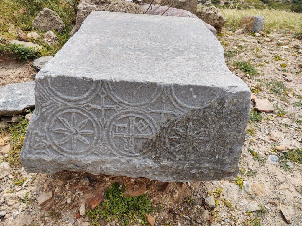
Several early Christian basilicas dating to Late Antiquity (4th–7th centuries CE) are present among the ruins. These churches were excavated by J. Demargne of the French School of Archaeology in 1899–1900. Architectural elements typical of basilicas, such as naves and aisles, are identifiable, though detailed plans remain unpublished. Inscriptions recovered within these churches have been studied but not fully published. The basilicas attest to the Christianization of Itanos and its religious transformation prior to abandonment.
Other Remains
Between the two akropoleis, scattered ruins of various buildings have been documented, though their specific functions remain undetermined. Surface surveys have identified numerous archaeological points, including wall fragments and pottery sherds. Despite the presence of Bronze Age settlements on the promontory, no Minoan remains have been found directly at the city site. The occupation sequence spans from the Geometric period through the Byzantine era, with visible remains reflecting this extended chronology.
Archaeological Discoveries
Pottery recovered at Itanos encompasses a broad chronological range, from the Protogeometric period through the Hellenistic and Roman eras, extending into Byzantine times. Finds include tableware, storage jars, and amphorae, though detailed analyses of manufacturing techniques or provenance are limited. Pottery was recovered from the east akropolis, habitation quarter, and necropolis.
Inscriptions constitute a significant component of the archaeological record, particularly those discovered in the necropolis. These texts mention the city’s name and its citizens, providing valuable epigraphic data. Additional inscriptions were found in the Christian basilicas, though many remain unpublished. Some inscriptions are preserved at the nearby Toplou Monastery.
Coins minted by Itanos have been identified, featuring distinctive local iconography such as mermaid-like figures. These coins primarily date to the Classical and Hellenistic periods, reflecting the city’s economic activity and political autonomy during those times.
Preservation and Current Status
The ruins of Itanos are generally fragmentary, with some areas better preserved than others. The east akropolis has suffered serious damage, limiting the visibility of architectural features. City walls survive in sections but are incomplete. Christian basilicas retain structural elements sufficient to identify their layout, though detailed restoration has not been reported. The necropolis contains visible tombs and funerary monuments, some partially excavated.
Modern archaeological efforts have prioritized documentation and surface survey over large-scale reconstruction. The site is protected under Greek antiquities law and incorporated within Natura 2000 and the Sitia Geopark, ensuring conservation. No specific restoration interventions or threats such as erosion or looting are detailed in current sources.
Unexcavated Areas
Several parts of the site remain unexcavated or only partially studied. The west akropolis, opposite the east akropolis, has not undergone extensive excavation. The full extent and detailed urban plan of the habitation quarter remain incompletely understood due to overlying Christian constructions and limited archaeological intervention. Surface surveys have identified numerous archaeological points across approximately 20 square kilometers of the Itanos territory, but many subsurface remains await investigation.
Future excavations are constrained by conservation policies and the site’s protected status. No specific plans for further excavation have been publicly announced, though ongoing fieldwork continues to refine the site’s chronology and spatial organization through non-invasive methods such as aerial photography and GPS mapping.


