Nimrod Fortress: A Historic Stronghold Near Banias, Syria


Visitor Information
Google Rating: 4.8
Popularity: Medium
Official Website: www.parks.org.il
Country: Syria
Civilization: Crusader, Medieval Islamic
Site type: Military
Remains: Castle
History
Nimrod Fortress is situated on a narrow ridge near Banias in the municipality of מבצר, נמרוד, Syria. Archaeological findings indicate that the earliest known fortifications at this strategic location were established around or shortly after 332 BCE, possibly during the Hellenistic period or Byzantine era. This initial construction predates later Crusader and Islamic occupations, indicating the site’s longstanding military significance.
During the 12th century, control over the fortress shifted repeatedly between Crusader and Muslim forces. The Crusaders occupied the site intermittently, with key figures such as Baldwin and the Zengid rulers battling over it. In 1157, Muslim forces led by Nur ad-Din recaptured the fortress following extended sieges. The Ayyubids, under Al-Aziz Uthman—the son of al-Adil and nephew of the famed Saladin—undertook major fortification efforts between 1227 and 1230. Their work transformed the stronghold into a critical defensive bulwark, then called Qal’at al-Subeiba, or “Castle of the Large Cliff,” to repel Crusader attacks and imperial incursions, especially during the Sixth Crusade spearheaded by Frederick II.
The fortress’s control briefly passed to the Mongols in 1260, but they soon lost it to the Mamluks. Sultan Baibars, a prominent Mamluk leader, strengthened and expanded the fortress significantly, adding large towers and reinforcing its defenses. The inscription dated to 1275, left by Baibars’s lieutenant Bilik, commemorates these construction works and remains visible on the site. Following the end of Crusader presence in the region by the late 13th century, Nimrod Fortress gradually lost its frontline military function but was retained as an important administrative center by the Mamluks. It served as a provincial seat and later, under Ottoman control after 1517, became a prison for rebellious nobles.
During the 16th century, the fortress was abandoned and suffered damage from natural events, notably an earthquake in 1759 that left parts of the structure weakened. In the 19th century, Druze settlers in the area gave the fortress its current name, Nimrod Fortress, linking it symbolically with the biblical figure Nimrod—a legendary hunter and king—although this name is a later historical addition rather than an original designation.
In the late 20th century, under Israeli administration, the fortress became a focus of archaeological study and preservation efforts, emphasizing its cultural and historical importance. It also featured in the 2006 Israeli film “Beaufort,” which highlights its enduring presence in regional history.
Remains
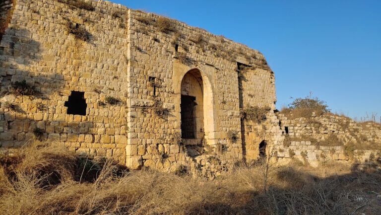
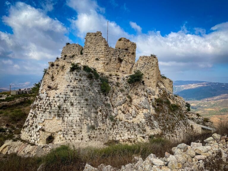
Nimrod Fortress stretches roughly 420 meters along a narrow ridge, with widths varying from 60 to 150 meters, conforming closely to the terrain of the southern slopes of Mount Hermon. It is enclosed by thick stone walls built using large squared blocks, which integrate natural cliffs as defensive barriers, particularly on the northern side where a steep valley makes additional fortifications unnecessary except for a single tower. This use of the natural landscape enhances the fortress’s defensive capabilities by limiting approaches on several sides.
The fortress’s defensive design includes numerous rectangular and semi-circular towers along its walls. The southern wall, facing the more accessible approaches, features about ten towers that guard the area rigorously. The western side contains four large towers positioned strategically to protect a natural gathering spot where attackers might assemble. A distinctive feature of these western fortifications is a ruined tower with an underground tunnel or escape passage built from finely cut stone blocks. This hidden corridor starts by heading north and then turns east toward the valley, offering a discreet route from the fortress.
At the eastern end of the complex stands the “keep,” known locally as the migdāl al-‘izz or “tower of strength.” This inner stronghold is positioned above the rest of the fortress and included the residence of the governor. Archaeological remains reveal luxurious halls, water pools, and multiple rooms designed for comfort and governance. The keep was reinforced by four internal corner towers and accessed through a heavily fortified triple-gate system located at its northwest entrance, indicating its role as the most secure part of the fortress.
The fortress is clearly subdivided into two main areas. The upper section contains the keep and its immediate surroundings, while the lower western section includes administrative buildings, large water reservoirs, and stables for animals. Each of the two main gates in this lower section is integrated within defensive towers—one gate lies in the southern wall and the other on the western side—strengthening access control.
Architectural elements within the fortress reflect its complex history of construction and renovation. The eastern hall displays cross-shaped rib vaults, a style characteristic of Crusader construction phases, suggesting that Crusaders once made substantial use of this space. Later Mamluk additions introduced pointed arches and large towers to the fortress, marking evolving military architectural preferences. The ruins also include secret corridors and underground water cisterns coated with their original plaster, demonstrating sophisticated design for water storage and defense.
Notably, a carved inscription dating to 1275 by Sultan Baibars is etched near the ruins of a gate tower. This inscription records the major renovations undertaken during Mamluk rule. Close by, a stone relief depicts Baibars’s emblem, featuring a young lion playfully interacting with a mouse—a symbolic motif associated with the sultan.
Water management was a vital aspect of the fortress’s design. Among the notable features is a large cistern approximately 9 by 25 meters in size with an internal stairway accessing its depths. Additionally, a water fountain (sabil) built in 1240 by Al-Sa’id Hasan ibn Al-Aziz Uthman reflects the period’s efforts to ensure reliable water supply within the strongly fortified site.
Some parts of the fortress show damage from earthquakes, particularly the event in 1759. A large square tower built by Baibars retains three defensive floors and a characteristic sloped vaulted roof, though it stands partially ruined. Despite weathering and human abandonment over centuries, much of Nimrod Fortress’s robust stonework and defensive features remain visible, bearing witness to its layered history and strategic role guarding the route between Galilee and Damascus.
Nearby sites