Castle of Moura: A Medieval Fortress in Portugal


Visitor Information
Google Rating: 4.4
Popularity: Medium
Official Website: www.cm-moura.pt
Country: Portugal
Civilization: Early Modern, Medieval European, Medieval Islamic, Roman
Site type: Military
Remains: Castle
History
The Castle of Moura is a medieval fortress situated in the municipality of Moura, Portugal, originally constructed by the Moors between the mid-11th and early 12th centuries. This stronghold was established atop an earlier Iron Age fortified settlement known as a castro, a site that had previously been inhabited by Romans and Visigoths, reflecting a long history of occupation before the Muslim presence.
During the period of Muslim rule, Moura served as the capital of the Al-Manijah province. A legendary event from 1166 recounts how the Christian conquest of the town was achieved through an ambush by two brothers, Pedro and Álvaro Rodrigues, who killed the Moorish mayor Bráfama. They then disguised themselves to gain entry into the castle, allowing the Christian forces to capture it. According to local legend, the Moorish princess Salúquia, fiancée of the Muslim governor Abu-Hassan, upon discovering the deception and the death of her beloved, took her own life by leaping from the castle tower. This tragic story is remembered in local place names and is symbolized on Moura’s coat of arms.
King Afonso I granted Moura its first official charter, or foral, around 1171, a document that was later confirmed by King Afonso II in 1217. This period was marked by ongoing conflict and contested control between Christian and Muslim forces. By 1232, definitive Christian control was established. Under the reign of King Dinis (1279–1325), the castle underwent significant reconstruction that incorporated existing Moorish walls, and a new foral was issued in 1295. A similar charter was also granted to the local Moorish community, reflecting a degree of accommodation and coexistence.
In 1320, the Order of Aviz, a military-religious order, assigned a portion of church revenues from Moura and the nearby town of Serpa to fund the maintenance of the castle. The village expanded considerably during King Fernando’s reign (1367–1383), prompting the addition of a second defensive line of walls. In the 15th and 16th centuries, further changes were made under the direction of the architect Francisco de Arruda, including the construction of walls separating the dungeon from the Salúquia and clock towers. Another foral was issued in 1512 by King Manuel I, updating the town’s privileges and administration.
Religious presence within the castle walls increased in 1562 when Dominican nuns founded a convent that was built atop the foundations of the former mosque, demonstrating the Christianization of the site. The fortress was reinforced in 1655 amid the Portuguese Restoration Wars with bastioned walls designed by Nicolau de Langres during the reign of King John IV. However, the castle suffered damage in 1707 during the Succession Wars, when parts of its defenses were deliberately destroyed following the Spanish withdrawal. It was also affected by the major Lisbon earthquake of 1755.
In the 19th century, parts of the castle’s walls were dismantled, with stones repurposed for local building projects such as the construction of a lagar (olive oil mill) named Vista Alegre. The convent within the castle was abandoned by 1875. Starting in 1959, restoration efforts were initiated, including consolidation of the towers and walls and the reconstruction of the church. Archaeological investigations conducted in 1981 uncovered Roman funerary tombs and structures dating back to the first century, highlighting the site’s deep historical layers. Recognized for its cultural importance, the castle was designated a Property of Public Interest in 1944 and has seen ongoing preservation and enhancement programs, including the creation of protected zones established in 2010.
Remains
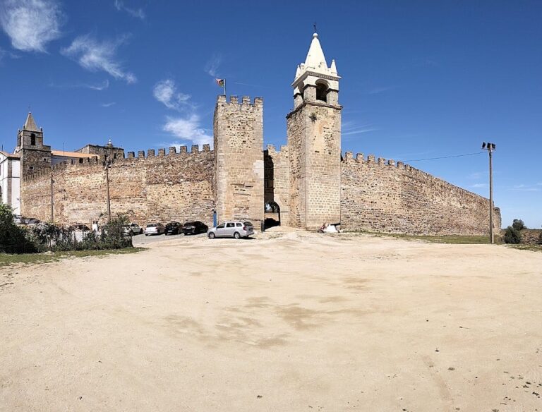
The Castle of Moura is perched on a limestone hill roughly 184 meters above sea level, overlooking the meeting point of the Rio Ardila and the Brenhas and Lavandeira ravines. Its defensive position, commanding views from the northeast edge of the town, reflects its strategic importance. The castle displays an oval-shaped layout, measuring approximately 200 by 120 meters, and consists of a main enclosure separated by walls into distinct sections.
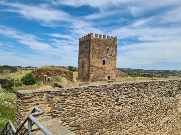
Within the fortress lies an alcazaba, or citadel, positioned in the southwest part of the enclosure. This area is fortified by walls with remnants of square towers and is protected by a rectangular keep tower accompanied by a smaller adjacent tower and a semi-circular corbel on its northern face. The keep tower’s battlements are adorned with prismatic pyramidal merlons—stone projections that provide defensive cover. Inside, its first floor, known as the Sala dos Alcaides, features an elegant vaulted ceiling with ribbed, pointed arches supported by eight slender columns. This chamber connects through a corridor to the walkway along the walls (called the chemin de ronde) and to the terrace.
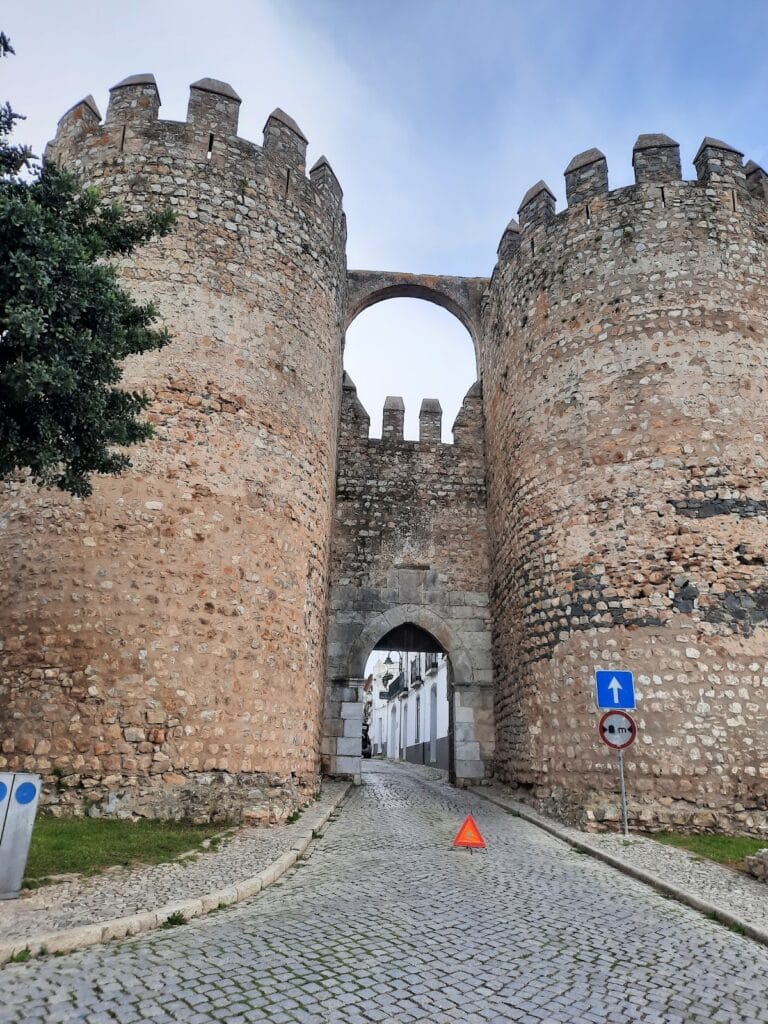
The castle’s northern defensive line includes a barbican, an outer fortification, where segments of the walls survive along with a trapezoidal tower and several other prominent towers. Among these are the Salúquia Tower, a semi-ruined circular tower to the northeast of the barbican, notable for an arch in its rearmost wall providing access to the terrace, and the clock tower to the southeast, which is square in plan, battlemented, and also fitted with prismatic merlons. A corridor from this tower links to the terrace, allowing movement along the defense line. Many wall sections retain their vertical masonry and wall-top walkways, though in some places the protective merlons are no longer present.
Access to the castle is through several gates. The Alcazaba door is situated between the main keep and the smaller tower. The principal entrance in the southeast corner features a pointed arch framed by an alfiz—a rectangular decorative border common in Moorish architecture—which leads into an elbow-shaped corridor that runs beneath the building housing the library. Additionally, a smaller door exists on the northwest wall.
Inside the barbican, the ruins of the Dominican Convent of São Domingos are found, constructed starting in 1562 on the remains of the earlier mosque. The convent’s church has a rectangular layout with a single nave, including a side chapel on the southern (epistle) side, and a belltower positioned on the northern end. The principal facade displays a stepped gable adorned with decorative windings, two rectangular windows, and a set of three vaulted arches forming the galilee, a covered porch area. On the southern face, a counter-curved doorway offers additional entrance, and a doorway near the presbytery (the space around the altar) is topped by a carved coat-of-arms on its lintel panel (tympanum). Inside, the nave is tiled and contains a raised choir loft extending over both the galilee and part of the nave.
The side chapel holds a Manueline-style tomb belonging to Pedro and Álvaro Rodrigues, the historical figures credited with the castle’s Christian conquest in the 12th century legend. The chapel’s main altar features vaulted ceilings and opens to the nave through a large rounded arch supported by pilasters.
Surrounding the town are 17th-century bastioned fortifications with a distinctive star-shaped design. These walls have sloping faces characteristic of the artillery-era defenses and were originally encircled by a moat, though much of it has since been filled in. Throughout the castle, both square and circular towers bolster the outer walls. In the 19th century, one particular tower was adapted to function as a clock tower, integrating new uses into the medieval fabric.
Together, these remains testify to the Castle of Moura’s long and layered history, with architectural elements reflecting influences ranging from Moorish origins to later Christian military and religious developments, as well as adaptations through times of warfare and peace.
Nearby sites