Qasr Bshir: A Late Roman Frontier Fort in Jordan


Site at a Glance
- Rating
- 4.2
- Popularity
- Very Low
- Country
- Jordan
- Primary era
- Classical
- External website
- Open
- Eras represented
- Classical
- Civilizations
- Nabataean, Roman
- Site type
- Military
- Remains
- Fort
On this page17 sections
History
Qasr Bshir is a late Roman military fort in Jordan, built between 293 and 305 AD during the Tetrarchy, the system established by Diocletian in which two senior emperors and two junior Caesars shared imperial power. Constructed on the eastern frontier of the province of Arabia, it formed part of the Limes Arabicus, a network of forts, roads, watchtowers, and water-control stations rather than a continuous wall. The fort helped monitor movement across the frontier, protect roads and water supplies, and respond to raids and later threats from the Sasanian Empire.
Construction during the Tetrarchy
Qasr Bshir was known in Latin as Castra Praetorii Mobeni or Praetorium Mobeni. A building inscription above the southwest entrance states that Aurelius Asclepiades, governor of Arabia, ordered Castra Praetorii Mobeni to be built from its foundations. This wording indicates a new Roman construction rather than the rebuilding of an earlier Roman fort. The inscription names Diocletian, Maximian, Constantius, and Galerius, the four emperors of the Tetrarchy.
The fort occupied a central position in the frontier system, about 15 kilometres northeast of the legionary camp of Betthorus, now Lejjun. Together with Qasr eth-Thuraiya and other outposts, it helped oversee the southeastern Roman frontier. Its position also linked military surveillance with the control of roads, water sources, trade, and movement through the steppe.
Qasr Bshir was probably intended for a cavalry detachment, although neither the inscription nor the Notitia Dignitatum identifies its garrison. The accommodation and feeding arrangements could support up to 69 horses or camels, while a full late Roman cavalry detachment is estimated to have included about 120 to 150 personnel. Animals may also have been kept in the courtyard or outside the fort, distributed among nearby posts, or used according to alternating garrison and patrol duties.
Earlier occupation and Roman use
The fort itself has not yielded surface pottery proving occupation before the late third century, but nearby remains point to an earlier Nabataean presence. One associated building incorporates the foundations of a square Nabataean tower, leading to the interpretation that an earlier structure occupied part of the settlement area before the Roman building was erected over it.
Roman military occupation continued throughout the fourth century. Excavations produced fourth-century pottery and coins, including a coin dated to 347 or 348 and another from the period between 340 and 365. The pottery assemblage indicates largely continuous Roman activity from the late third or early fourth century until the late fourth or early fifth century. The fort was probably abandoned during the fifth century, no later than about 500 AD.
A major earthquake in 363 AD devastated Petra and damaged buildings at Betthorus. The same earthquake probably affected Qasr Bshir, although the extent of the damage remains uncertain. After the Roman garrison departed, archaeological evidence indicates that the site was not occupied between the middle of the fifth century and the Umayyad period.
Umayyad reuse and final abandonment
During the Umayyad period, probably in the seventh century, the abandoned fort was temporarily reoccupied. The Umayyads ruled the early Islamic caliphate from 661 to 750 AD. Pottery, animal remains, and an Arab coin belong to this later activity, and the fort may have been reused as a caravanserai. Alterations to the entrance defenses have also been associated with the Umayyad phase, although the date and origin of the projecting defensive structure remain debated.
The barracks surrounding the courtyard collapsed during or shortly after the Umayyad occupation, possibly in the earthquake of 747. The fort was then permanently abandoned, apart from possible occasional transient use. In the late Ottoman period, a courtyard cistern was deliberately blocked and made unusable by filling it with stones taken from the ruins and apparently throwing animal carcasses into it. This may have occurred during tribal conflict or the First World War, but the precise circumstances are uncertain.
Rediscovery, investigation, and conservation
Western travelers recorded Qasr Bshir and its inscription in the late nineteenth century. Alfred von Domaszewski and Rudolf Ernst Brünnow investigated the fort during expeditions in 1897 and 1898 and produced an early detailed plan. Their work also established the first scholarly record of the building inscription.
The Central Limes Arabicus Project examined Qasr Bshir in 1982 and 1985 as part of a wider study of the frontier system centered on Betthorus. The investigations produced stratigraphic evidence, pottery, coins, animal remains, and a revised plan that clarified the fort’s likely cavalry function. The 1985 campaign also recorded illicit excavation in the courtyard, where deposits had been disturbed down to bedrock and mixed with modern debris. Even so, the excavations identified the original courtyard surface, wall foundations, stable installations, a possible upper-level access walkway, and the Roman building constructed over the Nabataean tower foundation.
Experiments tested long-distance communication between Qasr Bshir, Betthorus, Qasr Abu el-Kharaq, and other frontier posts. Mirrors could be seen for up to about 5 kilometres in daylight, while torches were visible for up to about 10 kilometres at night. Wind could obstruct smoke signals. Later research used aerial photography and declassified satellite imagery to examine the fort within its wider frontier landscape. Jordanian aerial archaeological surveys have operated since 1997 with the participation of the Royal Jordanian Air Force, the Department of Antiquities, and the Council for British Research in the Levant.
Qasr Bshir was visited during the 18th Congress of Roman Frontier Studies in Jordan in September 2000. Jordan placed the fort on its national Tentative List for UNESCO World Heritage designation on 18 June 2001. It is among the best-preserved Roman frontier installations in Jordan, but earthquakes, structural decay, vandalism, graffiti, and collapsing towers have placed it at serious risk. The Qasr Bshir Conservation Project began in late 2022 under the patronage of Prince Hassan bin Talal, initially concentrating on the entrance and its inscribed lintel. A three-dimensional exterior scan has been completed, with broader surface and subsurface scanning planned.
Remains
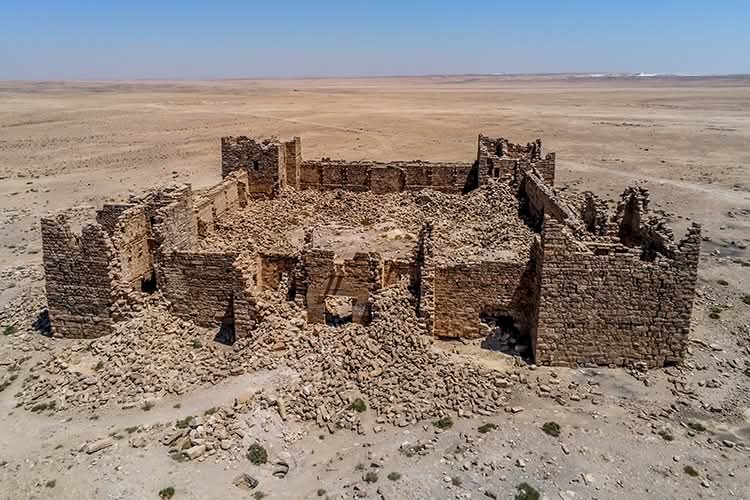
Qasr Bshir stands at about 800 metres above sea level on the Moab Plateau, roughly 80 kilometres south of Amman and approximately 15 kilometres northwest of modern Al-Qatrana. The fort occupies a shallow depression near a gentle rise, overlooking steppe to the north, east, and west. Nearby wadis drain westward toward Wadi Mujib, while Wadi Su’aydah lies to the north. The nearly square fort has a slightly trapezoidal plan, four projecting corner towers, a central courtyard, rooms built against all four curtain walls, and a principal entrance in the southwest wall.
Fortifications and towers
The fort measures approximately 56.30 metres along the southeast side, 57.05 metres along the southwest, 56.75 metres along the northwest, and 55.45 metres along the northeast. Its area is about 0.31 hectares. The walls and towers were built together in a single homogeneous construction phase, although the towers were extended upward after the walls had reached the level of the wall walk.
The curtain walls consist of two limestone faces enclosing a rubble-and-mortar core. Large, mostly rectangular blocks form the lower outer courses, while smaller stones and ash-rich lime mortar occur higher up. The walls are about 1.50 metres thick at the base and narrow to approximately 35 centimetres at the highest surviving course. Plaster remains on the inner faces. The wall walk probably stood about 6 metres above ground, while the surviving wall reaches at least about 7 metres near the entrance. The upper parapet, wall walk, and lost crenellations can only be partly reconstructed.
Corner towers
Four square corner towers project about 3.05 metres beyond the curtain walls. Each measures roughly 11 to 12 metres on a side and originally rose through three storeys. The best-preserved southern tower remains slightly more than 10 metres high. Each tower contained three rooms on every floor. The largest room occupied the outer corner, measuring about 4.83 by 4.65 metres in one survey, while the other rooms measured approximately 3 by 3.35 metres and 2.90 by 4.72 metres. Another survey gives the largest room as about 5.5 by 4.6 metres.
Stone arches supported the ceilings, with long stone beams resting on the arches and set into the outer walls. The upper floors probably had stone-slab floors. A rectangular stairwell occupied the corner facing the courtyard in each tower. The stairs, about 1.05 to 1.10 metres wide, turned around a central rectangular pier and used intermediate landings to reach the flat roof.
The upper platforms probably served for surveillance and signaling and could also be used as fighting positions. Small slit windows occur mainly on the third floors. Narrower openings on the second floors probably functioned as loopholes, while embrasures there may have accommodated ballistae. The southwest tower’s exterior walls have collapsed since the nineteenth-century surveys. Another tower is reportedly supported by only one surviving cornerstone, while the remaining towers still preserve several storeys but are structurally endangered.
Entrances and internal access
Southwest entrance
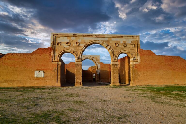
The principal entrance is a single-lane portal about 2.65 metres wide in the center of the southwest curtain wall. Two smaller towers, each approximately 6 metres wide and projecting about 3 metres from the wall line, flank the passage. The entrance has a stone lintel and a relieving arch. Above it, a Latin inscription is set within a tabula ansata, a stone panel with projecting dovetail-shaped ends.
A projecting structure above the entrance includes a machicolation, a defensive opening or gallery over the area immediately below. It was once considered an Umayyad addition, but later comparative architectural research interpreted it as a late Roman, probably Tetrarchic feature. Its precise origin remains uncertain. The entrance towers were accessible from rectangular rooms on both ground and upper floors. Their side walls formed the passage within the fort, while their inner faces opened toward the courtyard. No stone stairways survive in these smaller towers, which may have been reached by wooden structures.
Northwest postern
A smaller postern pierces the northwest curtain wall near the western corner tower. Its opening is about 0.95 metres wide, and its passage measures approximately 1.30 metres across. A barrel vault covers the passage as it leads from the courtyard through the wall to the exterior.
Courtyard ranges and garrison facilities
A large central courtyard is enclosed by two-storey ranges of rooms built against the curtain walls. The interior walls intersect and partly interlock with the fortifications, showing that the ranges were planned with the fort rather than added as independent buildings. The northeast and southeast sides each contain seven rooms per storey, while the northwest and southwest sides contain six per storey, producing 26 rooms on each floor. Most rooms measure about 5 square metres, with slight variations in size.
Headquarters room
The largest interior room lies opposite the main entrance on the northeast side. It projects beyond the regular room range into the courtyard and includes a rear room or antechamber. Its larger scale and distinctive arrangement have led to its interpretation as the principia, the headquarters building of a Roman fort, where administrative and command functions were carried out.
Stables and upper quarters
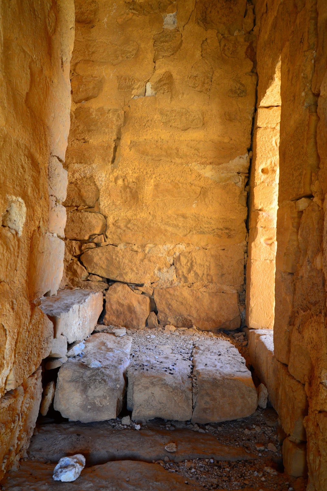
The ground-floor rooms probably served as stables. Twenty-three rooms contain three wall niches each, producing 69 niches. They are variously recorded at about 0.70 to 1.40 metres above the floor, approximately 0.80 to 1 metre wide, 0.60 metres deep, and 1.20 metres high. Their flat floors have no depressions for loose fodder, so wooden troughs may originally have been fixed to them. The animal remains include goats, sheep, cattle, chickens, camels, donkeys, horses, and other mammals. Small quantities of horse and camel remains, together with the possible feeding troughs, support the interpretation of a mounted garrison.
The rooms above the possible stables probably housed soldiers. They were plastered and were reached by elevated walkways or a terrace about 1.80 metres wide, apparently supported by stone pillars or a low wall. A surviving parallel wall is about 1.26 metres high and stands 1.80 metres from the inner stable wall, although its exact function is uncertain. The roofs of the interior ranges were probably flat, covered with stone slabs supported by stone cornices, and roughly level with the curtain walls. In an emergency, they could have served as additional fighting platforms.
Water supply and frontier resources
The fort’s water system included two cisterns in the courtyard and three more outside the walls. Another cistern lies about 50 metres north of the ruins. A large rectangular reservoir, probably contemporary with the fort, stood on the opposite slope less than one kilometre away. One measurement places it about 500 metres from Qasr Bshir. The reservoir measured approximately 64 by 47.5 metres and was enclosed by a wall about 2 metres thick.
A diverted wadi supplied the reservoir through a low masonry wall and channel, while a water channel from Wadi Mujib apparently carried collected runoff toward it. Silt prevents its depth from being established, but the reservoir has shown signs of recent maintenance and remained operational for local Bedouin use. The reservoir and the fort’s cisterns provided ways to collect and store scarce water in the arid frontier landscape.
Associated settlement and archaeological evidence
West or northwest of the fort are two connected buildings associated with a possible vicus, a dependent settlement. Building B has been almost entirely dismantled, leaving mainly the ground plan of its walls. Building A is a rectangular structure measuring about 17 by 19 metres, with rooms on three sides of an inner courtyard open toward the fort.
Building A incorporates the foundations of an earlier square Nabataean tower approximately 5 metres on a side. Excavation in 1985 confirmed that the Roman building was superimposed on this earlier structure. The excavated area measured about 4.2 by 2.1 metres and showed occupation during the late Roman and early Byzantine periods, approximately 300 to 324 and 324 to 400 under the chronological scheme used by the excavators.
Pottery from the area includes Late Roman, early Byzantine, Umayyad, Iron Age, and Nabataean sherds. A 1976 field survey collected 218 sherds, of which 74 could be closely dated. Thirty-four belonged to the Late Roman period and 40 to the early Byzantine periods. The assemblage indicates largely continuous Roman occupation from the late third or early fourth century to the late fourth or early fifth century.
Excavations exposed the original hard, mortar-like courtyard surface and the foundation of the southwest curtain wall on bedrock. The foundation rested on a leveling layer of compacted clay, crushed limestone, and pebbles. Successive soil and ash layers, collapsed masonry, fourth-century pottery, and coins also came to light. Animal bones were highly fragmented, with about 80 percent of the recorded mammal and bird fragments measuring less than one-quarter of their original length. Wild fauna included hares, foxes, and unidentified birds.
Construction materials and surviving inscription
A circular opening in the bedrock southwest of the fort contained the remains of a single-chamber short-flame lime kiln. It produced the ash-rich lime mortar used at Qasr Bshir and reflects a late antique Levantine technique intended to reduce fuel consumption in a region with limited wood. The quarry that supplied the limestone has not been identified.
The inscribed lintel above the entrance is framed by the tabula ansata. It was already cracked in two places when recorded in the late nineteenth century and now threatens to fall. Painted graffiti has defaced the entrance, while structural decay and the collapse of parts of the towers continue to endanger the surviving fort.