Burg Stotel: A Medieval Castle Ruin in Northern Germany


Visitor Information
Google Rating: 4.5
Popularity: Very Low
Country: Germany
Civilization: Medieval European
Site type: Military
Remains: Castle
History
Burg Stotel is a castle ruin situated near the municipality of Loxstedt in present-day Germany, erected by the medieval Counts of Stotel. Its location in the marshy area east of the northern part of the Wesermarschen region reflects strategic placement along a former bend of the Lune river, which feeds into the Weser.
The earliest evidence for the castle’s construction dates back to the mid-12th century, with dendrochronological analysis of wooden elements placing initial building phases between 1150 and 1160. However, the primary fortification period aligns more closely with the rule of Count Gerbert of Stotel, who governed from 1229 until 1267. Historical records first mention him in 1235 as “comes de Stoltelbrocke,” a Latin title meaning count of Stotel marsh. At this time, the castle was likely either newly established or substantially rebuilt. The name “de Stoltenbroke,” translating to “the proud castle in the marsh,” underscores its distinctive position within the wetland landscape.
The Counts of Stotel maintained their hold on the castle until the mid-14th century. Upon the death of Count Rudolf of Stotel in 1350 without a male successor, Burg Stotel passed as an escheated fief to Moritz von Oldenburg, a cathedral dean with ambitions connected to the Archbishopric of Bremen. Amid these power shifts, Rudolf’s widow claimed to be pregnant in an attempt to negotiate compensation from the archbishopric. This stratagem contributed to the castle being mortgaged—pledged in part—to the city of Bremen in 1365. This transaction represents Bremen’s initial foray into extending its territorial influence beyond its immediate city borders.
Following this, Bremen’s power grew in the region, gaining control over neighboring strongholds such as Langwedel by 1376, and eventually the larger areas of Stadland and Butjadingen in 1386. These acquisitions marked a significant expansion of Bremen’s reach during the late medieval period, with Burg Stotel serving as one of the early footholds in this process.
Archaeological interest in Burg Stotel revived after its rediscovery in 2006 during cable installation work. Excavations intensified in 2013, unearthing key details of the castle’s structure and confirming its historical significance. In recent years, efforts have been made to stabilize and partially reconstruct the foundations, preserving its remnants for public education and heritage.
Remains
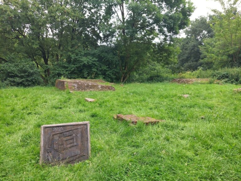
The surviving features of Burg Stotel present a well-defined nearly circular layout, characteristic of medieval defensive architecture adapted to the marshy surroundings. The castle walls, built primarily from large fieldstones gathered locally, stand with a base thickness of approximately 1.6 meters and reach heights of around 1.7 meters where preserved. This substantial stonework formed a robust enclosure suitable for the Counts of Stotel’s residence and defense.
One notable element is the remnants of a gatehouse located on the southern stretch of the wall. Its foundations measure 7.65 meters in width, with a gate passage designed about 2.35 meters wide externally and narrowing slightly to 1.90 meters internally. These dimensions reflect careful planning of controlled entry, typical of castles from the period. The gatehouse formed the principal access point to the interior courtyard and likely featured wooden superstructures supported by the stone base.
Thirteen pieces of wooden construction material found embedded within the ruin have been scientifically dated through dendrochronology, a method analyzing tree ring patterns. These dates provide precise chronological anchors, confirming the castle’s main development between 1225 and 1245, linked to Count Gerbert’s tenure. The wooden elements offer rare insight into medieval carpentry and construction phases at the site.
Geographically, the remnant fortress rests about 170 meters northeast of the village church of Stotel, positioned on a meadow near what was once a winding arm of the Lune river. The river’s course has since been artificially straightened and now flows roughly 400 meters to the northeast. The castle’s elevation is close to one meter above sea level according to the Normalhöhennull (NHN), marking its location within a marshland environment and explaining its designation as a “castle in the marsh.”
Today, the stone foundations have been preserved and selectively reconstructed to maintain structural integrity. These conserved remains allow visitors to observe the castle’s original outline and gate placement. The blend of sturdy stone walls and dated wooden components reveals much about the building techniques and strategic considerations of medieval counts ruling in northern Germany’s wetland fringes.
Nearby sites