Prague City Fortifications: The Defensive System of Historic Prague
Site at a Glance
- Rating
- 4.7
- Popularity
- Medium
- Country
- Czechia
- Primary era
- Medieval
- External website
- Open
- Eras represented
- Medieval, Early Modern, Modern
- Civilizations
- Austrian Empire, Duchy of Bohemia, Habsburg, Holy Roman Empire, Kingdom of Bohemia
- Site type
- Military
- Remains
- Wall
On this page24 sections
History
Prague City Fortifications in Czechia are the defensive works developed by successive Bohemian rulers around Prague Castle, Vyšehrad, the medieval towns, and later the united city, chiefly between the thirteenth and eighteenth centuries in Gothic and Baroque forms. They protected separate settlements before becoming a large fortress system, and their surviving fragments preserve the changing military history of Prague.
Early Fortified Settlements
Fortified settlement in the Prague area began before the medieval city. Hillforts at Baba, Butovice, Hostivař, Podhoří, Šárka, Zámka, and Závist used earthworks, timber, or stone to protect elevated settlements. Prague Castle was enclosed by an earthwork around AD 900, turning it into a fortified settlement. In the late eleventh century, Vratislav II, a Přemyslid ruler and the first king of Bohemia, strengthened Vyšehrad and moved his princely residence there.
Vratislav’s son Soběslav I later transferred the residence back to Prague Castle and began new stone defenses in 1135. Before the thirteenth century, however, the settled areas of Prague were not surrounded by one continuous wall. Protection came from defensible places such as Strahov Monastery, the fortified ends of the Judith Bridge, the Hospitaller commandery, the bishop’s court, and probably a waterlogged former branch of the Vltava.
The Medieval Town Walls
During the second third of the thirteenth century, the settlements on both banks of the Vltava became two royal towns enclosed by substantial defenses. Havel Town was founded south of the main market in the 1230s and was later incorporated into the fortified area of the Old Town. In 1257, Přemysl Otakar II founded the New Town on the left bank, now Malá Strana. Its walls connected with earlier defenses around the bishop’s court and the Hospitaller commandery.
The Old Town walls were built under Wenceslaus I between 1235 and 1253. They enclosed about 1.4 square kilometers and extended for roughly 3.8 kilometers. Malá Strana’s thirteenth-century walls followed the line of present-day Nerudova Street and continued around Břetislavova and Tržiště toward the Judith Bridge. Hradčany was fortified in the early fourteenth century, adding another defended district to the growing urban complex.
Charles IV, the fourteenth-century king of Bohemia and Holy Roman Emperor, initiated Prague’s greatest medieval expansion. From 1348 to 1350, the New Town received new Gothic walls, Vyšehrad was rebuilt and connected to them, and the Hunger Wall extended the defenses of Malá Strana across part of Petřín Hill. The older Old Town enclosure remained, despite attempts to create a single urban circuit.
The fortifications were involved in the Hussite Wars of 1420, a series of religious and political conflicts in Bohemia associated with the reform movement inspired by Jan Hus. During the late fifteenth century, the development of artillery led to stronger defenses at Prague Castle, including cylindrical towers on its northern side built under Vladislaus Jagiellon, the king of Bohemia and Hungary.
From Renaissance Defenses to a Baroque Fortress
Prague Castle expanded during the Renaissance with a second courtyard and new gates. In the seventeenth century, the separate urban enclosures were gradually incorporated into a larger military plan. A new Baroque defensive system was built around Prague between 1653 and 1730, using the historic towns as parts of one fortress city. General Count Innocentio Conti led the work, while Carlo Lurago worked on the right bank and Santino de Bossi on the left bank.
The new defenses generally stood outside the medieval walls and included five-sided bastions, projecting structures that allowed defenders to fire along the faces of the walls. They used exposed brick reinforced with stonework. Vyšehrad was transformed into a fortress between 1653 and 1727, while Hradčany was enlarged in 1631 to include Strahov and Pohořelec and enclosed by the Mariánské Walls.
The military value of the Baroque system was questioned because the surrounding heights allowed an enemy to bombard Prague. This weakness was demonstrated during the War of the Austrian Succession, a European conflict involving the Habsburg monarchy, when French forces captured Prague in 1741. French troops nevertheless spent heavily on completing and improving the defenses during their occupation. The fortifications were also involved in the Swedish siege of 1648, the occupation by French, Bavarian, and Saxon forces in 1741 and 1742, the Prussian siege of 1757, and two conflicts against Napoleonic forces in the early nineteenth century.
Decline and Demolition
After Prague’s capture in 1741 and further military failures, Maria Theresa revoked the city’s status as a fortified town on 30 April 1749. Prague was declared a fortress again in 1818, but during the nineteenth century the walls were increasingly used for controlling people and goods rather than for military defense. Three towers were adapted for attacks against the city during the Revolution of 1848.
Modern transport accelerated the decline of the old defenses. The first railway station inside the city was established in 1845, requiring a breach in the fortifications. Tracks passed through six new openings, which were closed at night by barred gates. After the Austro-Prussian War, the decision to abolish Prague’s fortifications was taken on 30 October 1866. The military administration sold them to the city, and systematic demolition began in 1875. Work proceeded through the New Town defenses toward Karlov, while on the left bank the walls between the Strahov and Písek gates were demolished before the beginning of the twentieth century.
Long periods of peace had already encouraged civilian reuse. Bastions, outer defensive strips, and ditches passed into private hands for housing or services, while other sections deteriorated. Buildings and roads later occupied parts of the former defensive lines, and the Old Town ditch was finally filled around 1760. The Vyšehrad defenses were transferred from military administration to the city in 1911.
Later Defensive Measures and Survival
Prague received new defensive measures in the twentieth century, including the pre-Second World War Outer Defense of Prague, also called the Prague Line, and postwar underground shelters associated with the construction of the metro. Construction and maintenance of that system were gradually abandoned after 1989. Flooding in 2002, including the flooding of the central metro network, weakened confidence in it, and later planning emphasized flood protection.
In 2009, excavation for a tunnel of the Blanka complex took place near the fortifications between Myslbekova Street and Powder Bridge. Cultural-heritage authorities stopped an alleged plan to remove much of the facing wall of Bastion XIV, while Prague’s city administration denied that it had planned the demolition. Surviving foundations beneath buildings and roads that follow former ditches or wall lines continue to preserve the outline of the demolished system. These routes include Národní třída, 28. října, Na Příkopě, Revoluční, and the north-south arterial.
Remains
Prague Castle and Hradčany
Prague Castle Walls
Prague Castle’s earliest defenses consisted of earth ramparts, with wooden palisades strengthening the western side. In the mid-eleventh century, Břetislav I had a stronger rampart built from earth, wood, and stone. Soběslav I replaced this arrangement in 1135 with a Romanesque fortress wall whose gateways were protected by square towers. The White Tower stood on the west, the Black Tower on the east, and a South Tower beside the princely palace. The palace’s southern wall formed part of the enclosure.
Late-medieval artillery defenses on the northern side included three cylindrical towers built under Vladislaus Jagiellon with the participation of Benedikt Rejt. These were the Powder Tower, also called Mihulka, a new White Tower, and Daliborka. Golden Lane developed along the northern wall. On the western side, Soběslav’s wall was placed farther east along the edge of the Third Courtyard, leaving the Church of the Virgin Mary, the castle’s oldest stone building, outside the enclosure. Later defenses included ditches and a bastion identified archaeologically and commemorated by the name of the Na Baště garden on the Fourth Courtyard.
Renaissance Castle Defenses
The Renaissance expansion created the Second Courtyard and added a northern gate reached by Powder Bridge and a western gate known as Matthias Gate. After the Mariánské Walls were constructed, the castle defenses lost their military importance. The ravine was filled, and the castle buildings were consolidated and remodeled into the New Royal Palace.
Hradčany’s later defensive circuit included the Hospital or Šárka Gate, the Strahov or Imperial Gate, the Saint Benedict or Paved Gate, the Písek or Bruska Gate, the Saint Ludmila Gate, a gate opposite the bridge to Prague Castle, and a gate beside the Archbishop’s Palace leading toward the Brusnice stream. The Písek or Bruska Gate near the Royal Summer Palace survives. The site of the Saint Ludmila Bastion is occupied by Kramář Villa, while the Saint Thomas, Saint Ludmila, and Saint George bastions were rebuilt or incorporated into later structures.
Hunger Wall
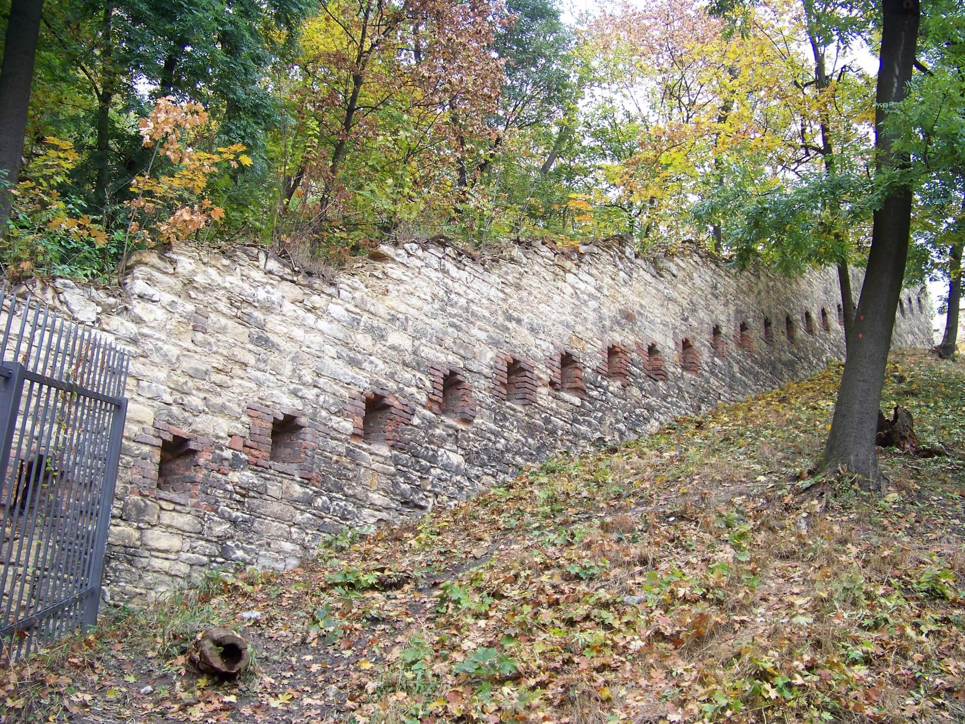
The Hunger Wall was built on Petřín in 1360 and 1362 to strengthen Prague Castle and Malá Strana. It ran along the western edge of Strahov Monastery, past Saint Lawrence Church on Petřín, and toward the Vltava, bringing Újezd and Strahov into the fortified area. The wall is about 6 meters high and 2 meters thick. Its inner side carried a wall-walk roughly 4 meters above ground, protected by battlements, and the structure included loopholes and about eight bastions. One bastion forms the base of the main dome of the Štefánik Observatory.
The gate at the end of the wall was first the Carthusian or Újezd Gate. It was rebuilt in Renaissance form in 1551 and in Baroque form at the end of the seventeenth century. In 1862 it was blocked and replaced by a larger Neo-Gothic gate with three openings, which survived until the abolition of the walls in 1891. Other fragments remain in the basements of houses.
Vyšehrad Fortress
Medieval Enclosure
Vyšehrad’s defenses were rebuilt and strengthened in 1348 to 1350 as they were connected to the Gothic walls of the New Town. The enclosure had walls with a wall-walk, a path along the top of a defensive wall, and battlements, raised parapets with openings for observation or weapons. About fifteen square towers stood at intervals of roughly 60 meters, each measuring approximately 7.5 by 7.5 meters.
The principal medieval gates were Špička, also called the Upper or Tábor Gate, on the Nusle and Pankrác side, and the Jerusalem or Prague Gate on the New Town side. Špička survived into the modern period, although only a small part remains. The Jerusalem Gate was destroyed during the Hussite Wars and is now blocked up. The Petřín Maze is a replica of Špička.
Baroque Bastions and Gates
Early in the Thirty Years’ War, the major European conflict of 1618 to 1648, Vyšehrad received advanced earth bastions. After 1639, a corner wall with the present Tábor Gate was added. Between 1653 and 1727, the upper part of the town was demolished as Vyšehrad became a fortress, and the chapter was displaced for a long period.
The numbered Baroque bastions included Bastion 33, Saint Bernard, at the northern connection with the New Town walls above the Botič valley; Bastion 34, Saint Paul or Saint Roch, toward Nusle; Bastion 35, Saint Peter or Saint Agnes, toward Pankrác and Podolí; Bastion 36, Saint Ludmila, on the southwest; incomplete Bastion 37, Saint Wenceslas, on the west; and Bastion 38, Saint Leopold, at the northwestern corner.
Three early-modern gates survive in the Vyšehrad area. The early Baroque Tábor Gate was built in 1653 with Renaissance features. Leopold Gate, sometimes called the French Gate, dates from 1676 to 1678. The Empire-style Chotek Gate, also known as the Brick, New, Cemetery, Prague, or Military Gate, was built in 1841 and 1842 on the northwest side at the former Jerusalem Gate.
Old Town Fortifications
Walls, Ditch, and Towers
The Old Town enclosure extended from the Vltava along the approximate lines of Národní, Na Příkopě, and Revoluční, continued beside the river at Na Františku, and then ran through Valentinská Street and Křižovnické Square toward the water. Its principal wall was more than 2 meters thick and over 10 meters high, with a wall-walk and battlements. Outside it lay a 15 to 20-meter-wide outer defensive strip, called a parkán, leading to a lower wall and then to a ditch about 25 meters wide and 6 meters deep.
Sixteen square stone towers, each approximately 15 meters high, projected into the outer strip at intervals of about 60 meters. Three survive between Národní and Bartolomějská streets. The former Havel Gate survives within the building at Rytířská 12, while part of its masonry bridge over the ditch has been exposed in the underground section of the Můstek metro station.
Gates and Later Urban Fabric
The enclosure contained gates associated with Saint Francis, Dlouhá Street, Saint Benedict, Saint Ambrose or the Mountain Gate, Havířská, Saint Havel, Perlová, Saint Martin or Zderaz, Saint Stephen, Saint Andrew, Saint John, Mostecká, Saint Valentine, and the gate behind the Jewish Town. Smaller pedestrian wickets also pierced the walls.
The Saint Ambrose or Mountain Gate was later replaced by the New Gate, known as the Powder Gate, at the end of Celetná Street on the route toward Kutná Hora. The Havel Gate stood near the New Market and Saint Havel’s Church, while the Saint John Gate served the movement of horses toward the Vltava. Buildings occupied parts of the former wall zone in the fourteenth century. The King’s Court stood near the Mountain Gate, on the site of today’s Municipal House, from 1383 to 1484. The ditch along present-day Na Příkopě was filled around 1760, although the street name became established only in 1870.
Malá Strana and the Left-Bank Defenses
Malá Strana Walls
Malá Strana’s walls followed present-day Nerudova Street before turning around Břetislavova and Tržiště toward the Judith Bridge. The Strahov Gate, also called the Black or Hansturkov Gate, stood in Nerudova Street until 1711. The Gothic Oujezd Gate, dating from 1257, stood at the intersection with Karmelitská Street and survived for a time after Malá Strana was enlarged. The original Písek Gate east of Prague Castle was replaced in 1588 by a new Písek Gate near the place known as Mouse Hole.
Mariánské Walls and Baroque Bastions
The Baroque Mariánské Walls extended from Powder Bridge through Pohořelec and Petřín to the Vltava, with the opposite section continuing toward Letná. They took their name from the Church of the Virgin Mary near Bruska Gate. The surviving Písek or Bruska Gate stood between the former Saint George and Saint Ludmila bastions.
Most gates had water-filled ditches, drawbridges, and iron portcullises, vertically sliding defensive grilles. The Baroque defenses generally used wooden bridges that could be removed quickly rather than drawbridges, except at Tábor Gate. The gates collected customs and other charges, were locked at night and during wartime danger or plague epidemics, and allowed late arrivals to enter through small wickets for an additional fee.
Parts of the Mariánské Walls west of Písek Gate were demolished in 1898 and replaced by a cadet school in 1900. The eastern section was demolished from 1901 onward. Sections of the left-bank Gothic and Baroque defenses survive near Petřín and Strahov, together with remnants incorporated into later buildings.
New Town Walls
Medieval Circuit
Charles IV’s New Town walls enclosed about 3.6 square kilometers and extended for approximately 3,430 meters. Their line ran from Vyšehrad through Karlov, along the routes of present-day Sokolská, Mezibranská, and Wilsonova streets, and reached the Vltava near Těšnov. The gates included Saint Peter or Poříčí, Mountain or Vienna, Horse or Saint Procopius, Rye, and Blind, Swine, or originally Saint John.
The first railway to the State Railway Station, now Masaryk Station, passed through six new openings in the walls. The Saint Peter Gate was replaced by a Baroque gate in Na Poříčí in 1663 and later by a Neo-Renaissance gate built in 1858 and 1859. The latter was demolished in 1875 or 1885. The Mountain Gate at Senovážné Square was rebuilt in Baroque form between 1655 and 1666 and was then called the New Gate.
Horse Gate and Surviving Sections
The Horse Gate at the upper end of the Horse Market, now Wenceslas Square, was rebuilt in Empire style in 1836 to designs by Peter Nobile. It was demolished in 1875, and the National Museum was soon built on the site. A garden and promenade surrounded the gate, and Count Karel Chotek established the promenade in 1827.
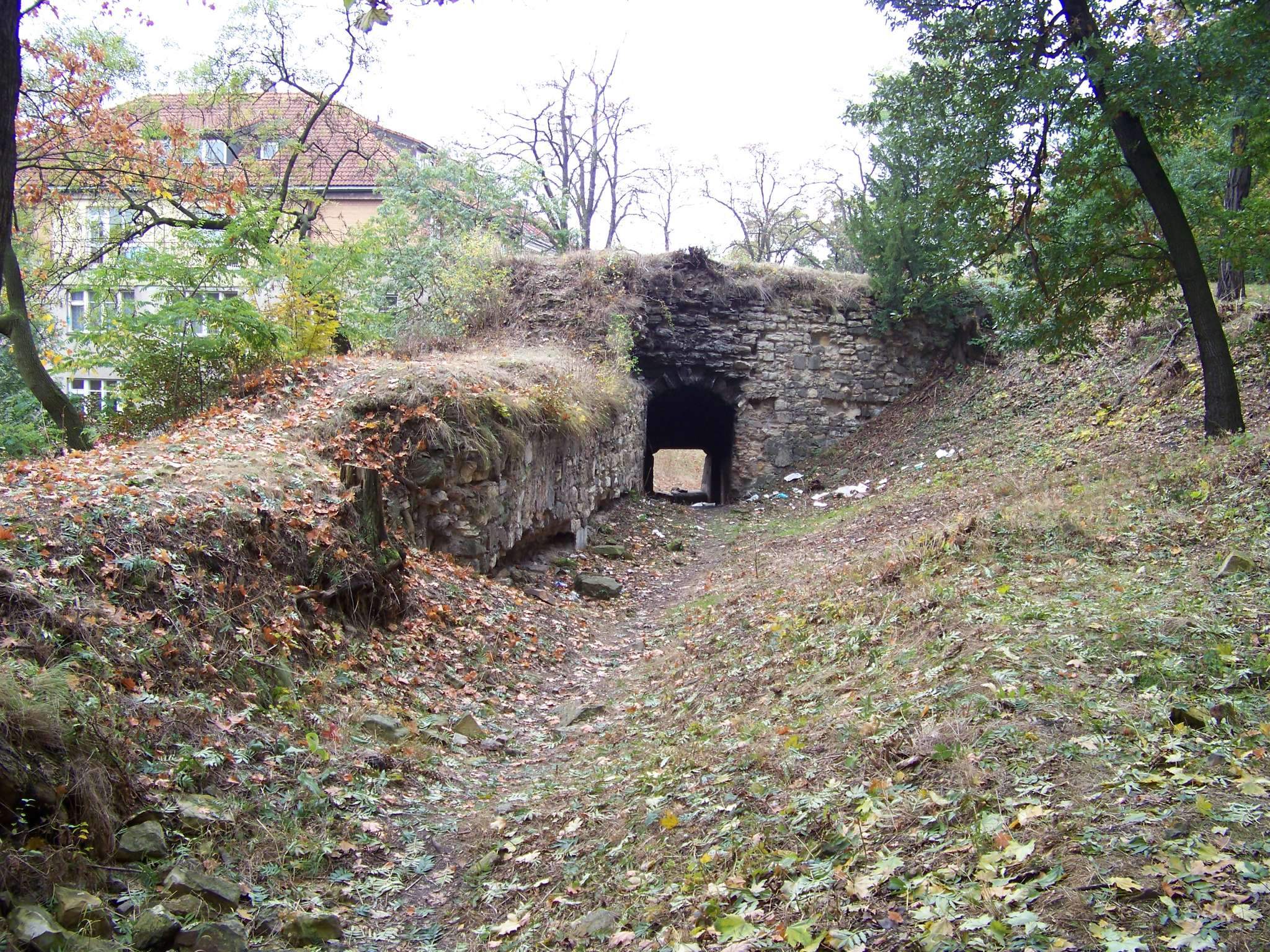
The New Town fortifications were incorporated into the Baroque fortress system. Bastions on the left bank were numbered from I at Újezd to XX near the present Straka Academy, while the New Town bastions ran from XXI at Těšnov to XXXII. Vyšehrad formed a citadel, a strongly fortified inner or independent defensive position, with Bastions XXXIII to XXXVIII and two additional advanced bastions near Tábor Gate. A medieval section of the New Town walls survives between Albertov and Folimanka Park in Nusle.
Surviving Urban Traces
Prague’s fortifications survive as an archaeological and architectural palimpsest of demolished, buried, rebuilt, and incorporated elements. The Vyšehrad walls, sections on Petřín and near Strahov, the left-bank Gothic and Baroque defenses, three Old Town towers, remnants of the Malá Strana circuit, and parts of the New Town walls remain visible or structurally preserved. Other foundations lie beneath houses, while roads including Národní třída, 28. října, Na Příkopě, Revoluční, and the north-south arterial follow former ditches or wall alignments.