Burg Draheim: A Hospitaller Fortress in Poland


Site at a Glance
- Rating
- 4.1
- Popularity
- Medium
- Country
- Poland
- Primary era
- Medieval
- External website
- Open
- Eras represented
- Medieval, Early Modern
- Civilizations
- Kingdom of Poland, Knights Hospitaller
- Site type
- Military
- Remains
- Castle
On this page12 sections
History
Burg Draheim is a Gothic fortress in Poland, built by the Knights Hospitaller between 1360 and 1366 on the site of an earlier Slavic stronghold. The Hospitallers, also known as the Johanniter or Order of Saint John, were a medieval religious-military order whose fortified residences also served as administrative centers. The castle became the seat of the Draheim commandery in 1366 and later developed into an administrative and military center in the region.
The Slavic stronghold and the Templars
The castle replaced a fortified settlement associated with the Drawian tribe. This earlier center developed from the seventh century to the middle of the twelfth century and, together with an auxiliary stronghold about 800 meters away, formed a major center of tribal authority. Bolesław III Wrymouth’s conquest of Pomeranian lands in the mid-twelfth century destroyed the settlement.
In 1286, Duke Przemysł II granted the region around Lake Drawsko to the Knights Templar, another medieval religious-military order. The Templars established a fortified site on the lake’s southern shore, later known as Tempelborch, while their commandery remained at Czaplinek. After the order was dissolved in 1312, its property passed first to the Margrave of Brandenburg and then, from 1345, to the Knights Hospitaller. The Hospitallers also made Czaplinek the seat of their commandery.
Hospitaller construction and regional conflict
The Hospitallers built a wooden castle in 1350 and replaced it with the present stone-and-brick fortress between 1360 and 1366. Its position on the narrow land between two lakes offered strategic advantages, while a salt route linking southern and northern Europe passed through the surrounding area. In 1366, during the reorganization of Pomeranian Neumark under Otto the Lazy, the fortress became the seat of the Draheim commandery. A commandery was an administrative and territorial unit governed from a commandery seat.
Rivalry developed between knights connected through the original grant to the Polish king and members of the order who considered themselves affiliated with Brandenburg. From 1372, campaigns by Swantibor I against Brandenburgers and Danes resulted in the capture of Tempelburg and Burg Draheim. The capture has also been attributed to Wartislaw VII.
Further conflicts followed during the Polish-Lithuanian union associated with Władysław II Jagiełło, who became the first ruler of the Jagiellonian dynasty. Local knights joined the Teutonic Order, bringing the fortress into the wider struggle between these powers. After the Teutonic defeat at Tannenberg in 1410, a major battle won by Polish-Lithuanian forces, Burg Draheim came under the administration of the starost Jan Wedel from 1422, during the reign of Władysław III, king of Poland and Hungary. A starost was a royal or state-appointed administrator responsible for a territory or estate. After the Second Peace of Thorn in 1466, the treaty that ended the Thirteen Years’ War between Poland and the Teutonic Order, the castle lost its military importance.
Administrative use, war, and decline
During the sixteenth century, settlement in the Draheim starosty expanded, as revenue registers record. The medieval fortifications were also enlarged. For more than two centuries, the castle served as an administrative seat before returning temporarily to military use during the Swedish Deluge, the Swedish invasion and occupation of much of the Polish-Lithuanian Commonwealth from 1655 to 1660.
In 1657, King John II Casimir pledged the castle to the Brandenburg elector under the Treaty of Bromberg in exchange for military assistance. The Polish commander Stanisław Potocki later refused to surrender it. In 1668, Hasso Adam von Wedel-Neuwedell captured the castle for Brandenburg, and it remained Brandenburgian until the twentieth century.
A fire in 1758, caused during Colonel Cosel’s defense against a Cossack attack led by General Denikoff in the Seven Years’ War, began the rapid decline of the former Hospitaller residence. Offices of the Prussian financial administration still occupied the castle at the end of the eighteenth century. In 1784, parts of the damaged walls were demolished for building material for the nearby Church of All Saints. The Kingdom of Prussia sold the castle grounds and adjoining farm to a private landed squire in 1818.
Conservation and present interpretation
Minor repairs and restoration in 1927 filled breaches and reinforced the walls. More extensive work, combined with archaeological investigations, took place from 1963 to 1968. These interventions secured the ruins in a permanently stabilized form. The site entered Poland’s monument register under number 190 on 29 April 1959.
In the 1990s, a private entrepreneur acquired the castle grounds and ruins with plans for a complete reconstruction. The property is now operated as an exhibit of medieval architecture by the private Motor and Technology Museum in Otrębusy. Burg Draheim remains an example of distinctive Hospitaller monastic architecture in Pomerania and provides evidence for the study of late-medieval material culture. Despite later additions, its original architectural concept survives.
Remains
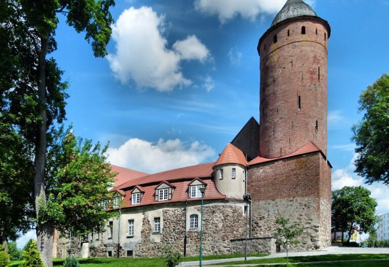
Burg Draheim stands on a narrow isthmus about 60 meters wide between Lake Drawsko to the west and Lake Żerdno to the east. The fortress occupies the position of the earlier Slavic stronghold. Its building platform was raised artificially by 6 meters and formed into a mound measuring approximately 50 by 50 meters. The main castle followed a quadrilateral plan of about 41 by 46.5 meters and used granite boulders and brick.
Fortress enclosure
The southern part of the castle consisted of a two- or three-storey wing measuring approximately 37.5 by 11 by 9 meters. Economic and prison rooms occupied the ground level, while residential chambers were placed on the upper floors. The enclosure was formed by curtain walls, the main defensive walls around a castle, about 2.5 meters thick and between 7.6 and 12.8 meters high.
Projecting covered galleries, or hoardings, were fitted to the walls with stairs. These timber structures allowed defenders to observe and attack enemies below. Numerous loopholes pierced the walls, and the northern curtain wall contained the entrance, reinforced by a gate tower. The surviving ruins preserve an incomplete profile of the defensive walls, whose remains were stabilized through archaeological and conservation work.
Courtyard and internal buildings
Stone courtyard
The interior included a stone courtyard with a horse trough, a lined well 1.8 meters deep, and a brick oven. The oven has since been reconstructed. Later building activity crowded the courtyard with additional structures while leaving a strip of about 2 meters between the houses and the enclosing walls, allowing extra light to reach the buildings.
Starost’s house
A western half-timbered house served as the residence of the starost. It measured approximately 19 by 10 meters and contained a basement and two storeys beneath a thatched roof. A smaller half-timbered house for the starost’s assistant stood in the eastern part of the courtyard and measured approximately 21 by 7.5 meters.
Storage and armory buildings
A shed with a basement occupied the southwestern corner and could hold approximately 20 hectoliters of beer. On the opposite side stood another building with a basement, later used as an armory. Two woodsheds, a guardhouse, and two wooden turrets were also added around the outer perimeter.
Moats, outer bailey, and later defenses
Moats between 3.5 and 5 meters deep protected the fortress to the north and south, while the two lakes defended its eastern and western sides. The outer bailey, an enclosed area outside the principal fortified enclosure, occupied the area of an older moat on the southern and northern sides. A river separated it from the mainland, and another moat separated it from the castle.
The slopes and raised ground were faced with stones to prevent erosion of the fortifications. A wooden bridge, possibly a drawbridge, connected the castle and outer bailey. It rested on roughly shaped, thick posts. During the sixteenth century, the surrounding earth ramparts were strengthened at the corners with semicircular bastions, projecting fortifications designed to provide flanking fire along adjoining walls. Four wooden watchtowers stood above them. Plans made in the mid-seventeenth century to surround the fortress with bastion defenses were never carried out.