Burgruine Kallmünz: A Medieval Hilltop Castle Ruin in Bavaria


Site at a Glance
- Rating
- 4.7
- Popularity
- Medium
- Country
- Germany
- Primary era
- Medieval
- Eras represented
- Bronze Age, Iron Age, Medieval, Modern
- Civilizations
- Duchy of Bavaria, Holy Roman Empire
- Site type
- Military
- Remains
- Castle
On this page9 sections
History
Burgruine Kallmünz is a medieval hilltop castle ruin in Germany, on a site whose earliest known fortifications were associated with Celtic groups living around the Naab and Vils valleys. The castle occupies the outer end of a rocky spur above the confluence of the two rivers, where river and overland routes meet. Its surviving principal residential building was originally Romanesque, while the oldest standing medieval structures date broadly from 1150 to 1280.
Early fortifications and the medieval refuge
Defensive installations stood on the Schlossberg roughly 2,000 years ago. The earliest fortifications were built of wood and belonged to Celtic communities in the surrounding valley. The wider hilltop also preserves archaeological evidence from the Paleolithic, Mesolithic, Neolithic, Bronze Age, Urnfield, Hallstatt, and Early La Tène periods, showing that the promontory had a long history of settlement and defensive use.
Around AD 900, an early medieval fortified refuge was established over the earlier Celtic complex. Its enclosing defenses protected a large area where hundreds of local inhabitants could seek shelter during Hungarian incursions. The outer rampart from this phase is now known as the Hungarian Wall, a modern name for an early medieval refuge defense associated with responses to Hungarian raids in Central Europe. The fortification was first mentioned in AD 983, in a document issued by Wolfgang, Bishop of Regensburg.
The site’s position also gave it an administrative role. An imperial customs post at the crossing of the Naab and Vils routes was already described as “old” in 1230. The builders of the later medieval castle are not definitively known. In 1271, Hugo von Kallmünz, a ministerial, was named as lord of the area. A ministerial was a medieval official or lower noble who commonly served a ruler or church lord in military and administrative duties.
Wittelsbach ownership and expansion
The castle first appears as Wittelsbach property in the Treaty of Pavia of 1329. The Wittelsbachs were a major Bavarian ruling dynasty whose different branches controlled territories and castles in Bavaria and the Palatinate. In 1344, Ludwig the Bavarian pledged the castle first to Regensburg, then to the Landgraviate of Thuringia, and later to Hesse. Members of different Wittelsbach branches later recovered it.
In 1358, Count Palatine Ruprecht I received permission to redeem the castle as his personal property. Building work connected with his ownership began in 1361. The principal construction program continued for much of the following century and was completed in 1459, when Duke Albrecht III recovered the castle and the market town of Kallmünz for Upper Bavaria. The works associated with Ruprecht I probably included the strengthened defensive circuit around the castle.
Destruction and abandonment
During the War of the Landshut Succession, Palatine troops captured and burned the castle in 1504. It was rebuilt afterward, but its renewed use was interrupted during the Thirty Years’ War, the major European conflict of 1618 to 1648. Imperial troops plundered the castle in 1633, and Swedish troops captured and burned it in 1641. After this destruction, the castle was left in ruins.
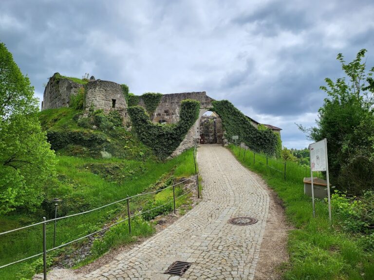
From the second half of the seventeenth century, the ruins became a readily available source of building material, especially limestone blocks. Municipal ownership began in 1793 and halted the systematic dismantling of the walls and towers. Local residents initiated conservation work from the late nineteenth century onward. The entrance-gate arch was restored, followed by repeated partial restoration and reconstruction of parts of the complex.
Protection and modern conservation debates
Burgruine Kallmünz is municipally owned and forms part of a network of more than 40 castles connected by the castle trails of the Regensburg region. It is protected as a listed architectural monument, while the castle site and its archaeological remains are also protected as a ground monument. This protection includes prehistoric and early historic ramparts, open-air sites from the Upper Paleolithic and Mesolithic periods, hilltop settlements from the Neolithic, Bronze Age, Urnfield, Hallstatt, and Early La Tène periods, and archaeological evidence within the medieval castle area.
Modern proposals affecting the site have prompted debate about the relationship between access improvements and archaeological preservation. In autumn 2010, plans called for changes to the access road, stages and seating areas, a wooden service building, a children’s playground, and fixed barbecue and fire areas. Local opposition argued that these measures would alter the character of the ruins. A citizens’ initiative gathered 570 valid signatures in twelve days, more than twice the 231 required, after which the mayor and municipal council unanimously supported the citizens’ decision.
Further proposals in February 2013 called for the road to the castle to be completely resurfaced. Concern that this work could damage an archaeological monument thousands of years old led to the re-establishment of the Bergverein Kallmünz, an association first founded in 1885. Its purpose was to seek changes to the road plan and protect the archaeological character of the hilltop.
Remains
Hilltop setting and defensive earthworks
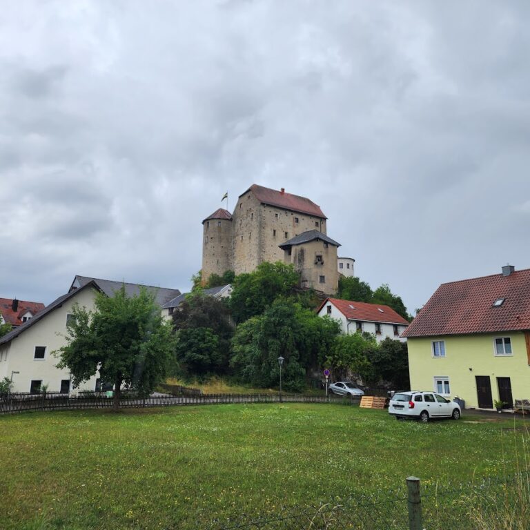
The castle is a Höhenburg, or hilltop castle, set on the outermost end of a rocky spur of the Schlossberg at 433.2 metres above sea level. The approximately three-hectare spur stands above Kallmünz at the confluence of the Naab and Vils, with steep drops toward both rivers. This elevated position placed the medieval stronghold above the surrounding routes and shaped the arrangement of its defenses.
A sickle-shaped transverse rampart cuts across the northern side of the spur. Dating from around AD 900, the rampart formed the outer defense of the large early medieval refuge settlement. Its modern name, the Hungarian Wall, reflects its association with refuge fortifications built in response to Hungarian raids. Other ramparts extend across the approach to the castle. About 1,000 metres before the tip of the spur, a two-phase outer rampart crosses the Hirmesberg and dates from the Middle Bronze Age, around 1600 BCE. About 100 metres before the medieval castle, a multi-phase inner rampart from the La Tène period, around 500 BCE, was later built over by the Hungarian Wall.
Residential and religious buildings
The two-storey polygonal palas was the principal residential and representative building of the medieval castle. Originally Romanesque, it contained two large knights’ halls, paired round-arched windows, and three-part pointed-arch windows. Residential rooms occupied the upper floor. Later additions and alterations introduced Gothic features, leaving the building as one of the most substantial surviving parts of the ruin.
A castle chapel was attached to the north side of the palas. A remnant of this chapel survives within the ruins, connecting the residential core with the religious functions of the medieval complex.
Tower and enclosing defenses
The round bergfried rises approximately 20 metres and has a diameter of 9.5 metres. Its walls are about 2.3 metres thick and are built from limestone ashlar, carefully shaped masonry blocks. The entrance is positioned about eight metres above ground level. A bergfried was the high fortified tower of a castle, used chiefly for defense, surveillance, and refuge rather than as the main residence.
The ring wall was approximately 1.2 metres thick and incorporated semicircular towers. A late Gothic zwinger and gatehouse were added in the fifteenth century. A zwinger was an outer defensive enclosure or passage between successive lines of fortification, allowing defenders to expose attackers to fire from the main walls. The ascent to the bergfried’s high entrance was renewed in 1671. In 1900, the tower received a new outer shell, and the castle gate was given a pointed arch.
The external walls reached two metres or more in thickness and were constructed of limestone masonry. Today the complex consists chiefly of the preserved bergfried, the substantial walls of the palas, extensive wall remains, and the surviving chapel remnant. The condition is predominantly ruinous, with partial restoration and conservation, while the castle ground itself remains an archaeological monument.
Nearby sites