Loughor Castle: An Anglo-Norman Fortress in South Wales


Site at a Glance
- Rating
- 4
- Popularity
- Low
- Country
- United Kingdom
- Primary era
- Medieval
- External website
- Open
- Eras represented
- Classical, Medieval
- Civilizations
- English, Norman, Roman
- Site type
- Military
- Remains
- Castle
On this page14 sections
History
Loughor Castle is a ruined medieval fortress at Loughor in the United Kingdom, approximately 10 to 11 kilometres west of Swansea. Founded shortly after 1106 by the Anglo-Norman lord Henry de Beaumont, Earl of Warwick, it formed part of the Norman advance into south Wales after Henry I granted him the Gower Peninsula.
A Norman stronghold in Gower
The castle stood in the Marcher territory of Gower. Marcher lords governed frontier regions along the Welsh border with unusually broad administrative and military powers, reflecting their distance from the central authority of the English Crown. From Loughor, the castle controlled the principal road across the peninsula from Swansea Castle, a strategic ford over the River Loughor, and an important coastal port.
The site had earlier been occupied by the Roman fort of Leucarum. Established around AD 75, the fort was abandoned in the mid-second century and reoccupied in the late third or early fourth century before the Roman military finally withdrew. Its name derived from the Celtic name of the River Loughor.
Loughor Castle was attacked and burned around the middle of the twelfth century, probably during the Welsh rebellion of 1151. It was rebuilt after peace was made between Henry II and Rhys ap Gruffydd, although warfare returned to the region after Henry II’s death in 1189. Near the end of the twelfth century, the castle probably passed to the English Crown as part of a settlement of debts owed by the Earls of Warwick.
Welsh and English struggles
In 1203, King John granted Loughor and the Gower to his ally William de Braose. After William quarrelled with the king in 1208, the Crown attempted to confiscate his lands. William allied himself with Llywelyn the Great, and his son Reginald continued the struggle after William’s death in 1211.
Llywelyn’s forces captured Loughor Castle in 1215, and Llywelyn granted the Gower to Reginald. Reginald later made peace with the English Crown, so Llywelyn removed him in 1217 and assigned the territory to the Welsh prince Rhys Gryg. Rhys Gryg is associated with the destruction of castles in the region as he consolidated his authority.
Llywelyn subsequently granted the Gower and Loughor Castle to his son-in-law John de Braose, who began repairing the castle around 1220. The property passed to John de Braose’s son William in 1232 and later to William’s son. Another attack in 1251 led to stronger defences and the construction of a stone residential tower during the second half of the thirteenth century.
Later medieval decline
In 1302, William de Braose granted the Loughor estate to his seneschal, John Iweyn, for life. In return, Iweyn owed an annual payment consisting of a collar for an English greyhound. After Iweyn’s death in 1322, control of the castle and adjoining lands was disputed by John de Mowbray, Hugh le Despenser, Humphrey de Bohun, Roger Mortimer, and Alice Roculf.
John de Mowbray was executed later in 1322 after rebelling against Edward II, and Alice Roculf received the lands. Following Edward’s deposition in 1327, they were returned to John de Mowbray’s son. During the late medieval period, Loughor Castle and the surrounding town lost strategic importance as the Welsh Marches were progressively brought under the authority of the English Crown.
The castle was described as derelict in 1587 and had become ruinous and overgrown with ivy by the nineteenth century. The tower ruin was reportedly used as a beehive in the eighteenth century. Its south-eastern corner collapsed in the 1940s, but the fallen masonry was left in place because it remained intact and had archaeological value. The ruin was transferred to the Ministry of Works in 1946, followed by archaeological investigations in 1969 to 1971 and again in 1973. Loughor Castle is now managed by Cadw as a scheduled monument, a legally protected archaeological or historic site under United Kingdom law, and lies within Loughor Castle Park.
Remains
The ringwork and early defenses
Earthwork enclosure
The medieval castle reused part of the earthworks of Leucarum and occupied the south-eastern corner of the earlier Roman fort. Its principal form was an oval ringwork, an early castle consisting of an enclosed bank and ditch usually defended mainly with timber. The surviving earthwork measures approximately 21 metres by 18 metres and rises 12 metres high. A surrounding ditch was about 5 metres wide and 2 metres deep, although only incomplete traces remain.
The southern side of the enclosure was naturally protected by a steep slope and marshy ground beside the River Loughor. The mound was built from layers of river gravel and coarse sand, covered with finer sand and clay that helped waterproof the earthwork and protect it from erosion. The original defences were primarily earth and timber, with a wicker palisade on top of the ringwork. An early wooden or stone tower may also have stood near the gateway, while a kitchen occupied the eastern side of the enclosure.
Roman predecessor
Leucarum had a rectangular plan. Its first defenses consisted of earthworks and palisades, later replaced by rendered walls. Only slight traces of the Roman fort survive within the later medieval site.
Twelfth-century rebuilding
Terraced mound
Debris from the attack and burning around the middle of the twelfth century partly filled the interior of the ringwork. The inner slope was then terraced and softened, while material was added toward the centre and inner bank. These alterations created the mound-like appearance visible today.
Stone buildings
Two stone buildings were erected near the centre of the ringwork toward the end of the twelfth century. One measured approximately 8 metres by 4.5 metres. The internal buildings from this phase do not survive above ground.
Stone enclosure and residential tower
Curtain wall
A curtain wall, the enclosing defensive wall of a castle, was built around the site in the early thirteenth century, probably during John de Braose’s repairs. It included a sally port on the northern side, a small protected passage through a fortification. Much of the wall was later quarried or removed for its stone, but surviving fragments reach approximately 1.5 metres in height.
Residential tower
After the attack of 1251, a square-section stone tower was added as living accommodation. It contained a basement and two residential levels, with three chambers, a garderobe, or medieval latrine, and a fireplace on the first floor. A gateway was built through the curtain wall immediately south of the tower, and two further stone buildings were added inside the enclosure.
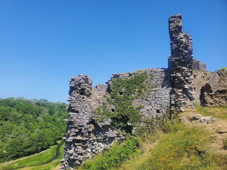
The surviving tower stands on the western side of the ringwork and measures approximately 7 metres by 8 metres at its base. Part of the former spiral staircase can still be seen in the fallen masonry in front of its west side. The tower ruin remains a prominent local landmark, while the curtain wall survives in fragments and the collapsed south-eastern corner of the tower lies on the ground.
Nearby sites