Strobilos: A Byzantine Fortress and Naval Base in Turkey
Site at a Glance
- Popularity
- Medium
- Country
- Turkey
- Primary era
- Medieval
- Eras represented
- Iron Age, Medieval
- Civilizations
- Byzantine, Menteshe
- Site type
- Settlement
- Remains
- Town
On this page8 sections
History
Strobilos was a Byzantine fortress, naval base, and settlement on Turkey’s southwestern Anatolian coast, opposite Kos and near Bodrum. Founded in the Early Middle Ages, it was among a small number of Anatolian settlements established in that period. Its position close to the main sea route between Constantinople and the Mediterranean made it a remote stronghold and a useful link in coastal defense.
Early medieval stronghold
The earliest known reference to Strobilos dates to 724, when the Christian pilgrim Willibald travelled there along the coast after visiting Ephesus and Phygela, then continued to Patara. Early descriptions present the place as a strong, isolated fortress suited to refuge or exile, despite its proximity to an important maritime route.
In 815, Theophylact of Nicomedia was sent into exile at Strobilos. A bishop and opponent of iconoclasm, the religious dispute over the use of sacred images associated with Emperor Leo V, he spent the final 30 years of his life there.
Byzantine administration and conflict
During the Middle Byzantine period, Strobilos served as a military base in the Kibyrrhaeot Theme, a Byzantine administrative and military province along the southern Anatolian coast. An archon, a Byzantine official, apparently supervised and defended the coast and collected customs. The settlement and fortress also appear among the province’s communities in Constantine Porphyrogenitus’s 10th-century work De Thematibus, which describes Byzantine administrative regions.
Arab forces attacked Strobilos in 924 and again in 1035. Turkoman forces, Turkic groups that had moved into Anatolia, plundered the settlement during the 11th century. Seljuk Turks captured the fortress around 1080, after which Byzantine forces retook and strengthened it under the Komnenian emperors.
In 1079, Maria, sister of the noble Konstantinus Kavalloures, founded a monastery dedicated to John the Baptist on her property in Strobilos. The monastery soon gained independence in church affairs and exemptions from various duties and taxes through Emperor Nikephoros III Botaneiates. These privileges reflect the influence of local nobility at the imperial court.
Trade and changing rule
Strobilos remained part of Byzantine maritime commerce. In 1082, Emperor Alexios I Komnenos granted Venetians the right to trade freely across the empire, and Strobilos was among the named ports, alongside Attalea, Chios, and Ephesus. The geographer Idrisi described it in 1154 as a small, densely settled seaside town and placed Astroboli between Telmessus, modern Fethiye, and Sampson, the Byzantine name for Priene. Under the Laskarid dynasty, which ruled from Nicaea after Constantinople fell in 1204, Strobilos retained commercial importance as a skala, or landing place. A concession issued by Emperor Alexios III in 1198 also included Strobilos in a list that named Samos, Rhodes, Kos, and Crete.
After the Fourth Crusade captured Constantinople in 1204, the partition of Byzantine territory assigned Strobilos to Latin rulers. Their rule did not take hold there, and the settlement came under Laskarid control instead. By 1269, Byzantium had lost the southern Carian coast, including Strobilos, to the Menteşe, a Turkish principality in southwestern Anatolia. The Menteşe strengthened the walls and appointed tax collectors; the area also became a base for Turkish pirates.
Strobilos declined in importance during the Middle Ages and passed under Ottoman administration between 1421 and 1451. Its population density remained unchanged through that transition. The name Aspat appears in connection with the Ottoman admiral and cartographer Piri Reis’s 1525 work Kitab-ı Bahriye, which also calls the locality Cühudluk Limanı, or Jewish Harbor. Evliya Çelebi, an Ottoman traveler and writer, recorded Aspat in the 17th century. A 1530 administrative register gives forms including Isravolos and Sıravalos. The name Çıfıt Kalesi, meaning Jewish Fortress, appears on cartographer Richard Kiepert’s 1904 map and has been explained by reference to the area’s Jewish population.
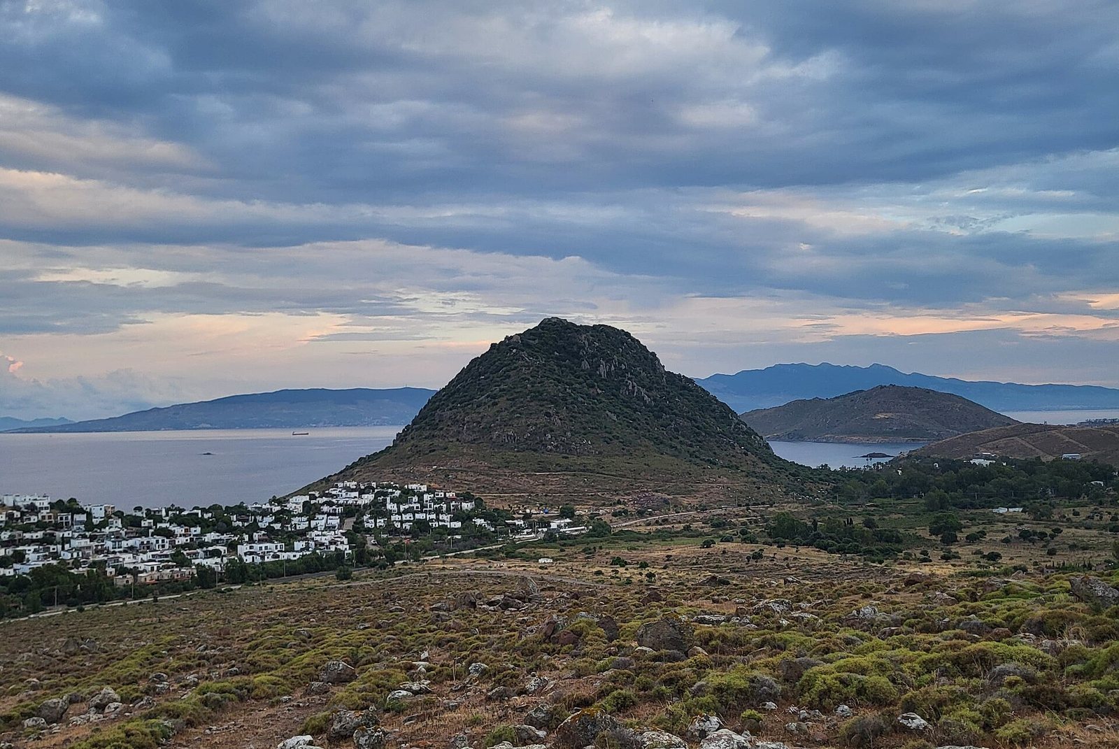
Strobilos is first recorded by name in the 8th century. Its name is thought to derive from a Greek word for cone or pine cone, in reference to the hill’s shape; the Turkish name Kozalak is also associated with that form. Aspat has been linked to the Greek Spatia, meaning sword-like or pointed. The historian Avram Galanti proposed a different origin in aspartos, meaning unsuitable for cultivation. Modern archaeological excavation and restoration are carried out by the archaeology department of Muğla University.
Remains
Settlement and built remains
Strobilos occupies a conical volcanic hill rising prominently from the sea. Its surviving buildings reflect Byzantine architecture and include monumental structures and two castles. Many buildings are ruined, while some remain partly standing. The arrangement of the remains links the summit settlement and fortifications with the larger site on the hill.
Summit settlement and fortifications
Traces of a Leleg settlement, associated with an ancient people of southwestern Anatolia and the Aegean, survive at the summit and date to the 7th century BCE. The later fortress known as Çıfıt Kalesi remained in use into the Ottoman period. The ancient settlement is thought to have served as the harbor of Termera, while the Azmak to its west formed an important trade route.
Thirteenth-century bath
Ruins of a bath dating to the 13th century lie west of the settlement. Restoration and conservation of the bath remains are overseen by Bodrum Museum.