Qasr Kharana: An Early Islamic Desert Meeting Place in Jordan


Site at a Glance
- Rating
- 4.3
- Popularity
- Medium
- Country
- Jordan
- Primary era
- Medieval
- Eras represented
- Medieval
- Civilizations
- Umayyad
- Site type
- Civic
On this page13 sections
History
Qasr Kharana is a well-preserved desert complex in Jordan, probably built during the Umayyad period, the era of the hereditary caliphate that ruled much of the Islamic world from 661 to 750. Standing about 60 to 65 kilometres east-southeast of Amman, it belongs to the early Islamic landscape of eastern Jordan and was completed in its first construction phase by 710. Its exact purpose remains uncertain, but its design and limited resources suggest a place intended for temporary meetings rather than permanent occupation.
Origins and Early Islamic Construction
The date of Qasr Kharana’s construction has been debated. Some proposals place its beginnings in the 620s, when the Sasanians controlled the region. A late Sasanian date remains possible, although it is generally considered unlikely. Stephen Urice instead argued for an early Umayyad date, approximately 661 to 684, partly because of the building’s Sasanian-style plaster decoration. Sasanian building methods and artistic traditions continued to influence early Islamic architecture after the Sasanian Empire ended in 651.
A small inscription in a large upper-floor room on the western side gives the date 24 November 710. This provides the latest possible date for completion of the building’s first construction phase. Another inscription in an upper room mentions the Umayyad caliph Al-Walid I, who ruled from 705 to 715, although the authenticity of that inscription is disputed. Three illegible Greek inscriptions are also present. One may refer to a military title, while another includes a character that could be the Roman numeral V. Their stones may have been taken from an earlier structure or from markers in the desert, but they do not prove that a Greek or Byzantine building previously stood at the site.
Construction proceeded in three stages. The first included the entire ground floor and the western part of the upper floor. The second added rooms along the southern and eastern sides of the upper floor. The third phase, which remained unfinished, involved rooms in the northwest corner. This sequence shows that the building developed beyond its initial plan, although the final arrangement was not completed in every area.
Purpose and Historical Interpretation
The name qasr is an Arabic word that can mean palace, castle, or fortified residence, but it does not establish a military function. Qasr Kharana has been interpreted at different times as a Crusader castle, a military stronghold, an agricultural outpost, a caravanserai, a recreational palace, and a temporary meeting place. Its location away from the main early Islamic trade routes, its limited water supply, and the form of its rooms have made several of these interpretations difficult to sustain. The prevailing view is that local Bedouin leaders used it for temporary gatherings, possibly to conduct meetings rather than to maintain a long-term settlement.
Some rooms could accommodate animals, while the many-roomed plan and central courtyard were suitable for meetings. Water was drawn chiefly from Wadi al-Kharana, where gravel pits called thamail retained water after the wadi flowed across its rocky bed. These pits could be washed away by later floods, and the installations used during the building’s occupation cannot now be identified. The available water collection and storage would not have supported large groups for extended periods, which reinforces the interpretation of short-term use.
Rediscovery, Study, and Conservation
By the nineteenth century, Qasr Kharana had been abandoned and neglected. The English explorer Sir John Edward Gray Hill encountered two deep cisterns in 1895 and published the first known written reference to the building in 1896. His reading of the entrance orientation, wall openings, and several rooms was mistaken, leading him to identify the structure as a Crusader fortress and water store.
The Czech geographer Alois Musil visited in 1898, 1900, and 1901 and likewise regarded the building as a fortress. His drawings showed battlements for which there is no other supporting evidence, and his suggestion that they had been dismantled for reuse is unsupported. Antonin Jaussen and Raphael Savignac published a major description in 1922. In 1946, Nabia Abbott produced a complete translation and analysis of the inscriptions, making it possible to date the first construction phase no later than 710.
Several earthquakes damaged the abandoned complex, and cracks eventually separated parts of the western and southern walls from the rest of the structure. Extensive restoration took place in the late 1970s, including work carried out between 1976 and 1979. Urice studied the building from 1977 to 1981 and advised on the restoration before publishing his research as Qasr Kharana in the Transjordan in 1987. The restoration changed some elements, including the closure of an eastern doorway and the use of cement and plaster that differ from the original materials. An area of about two hectares visible from Qasr Kharana also contains Epipalaeolithic remains, including settlement structures at Kharaneh IV that are approximately 20,000 years old.
Remains
Layout and Exterior
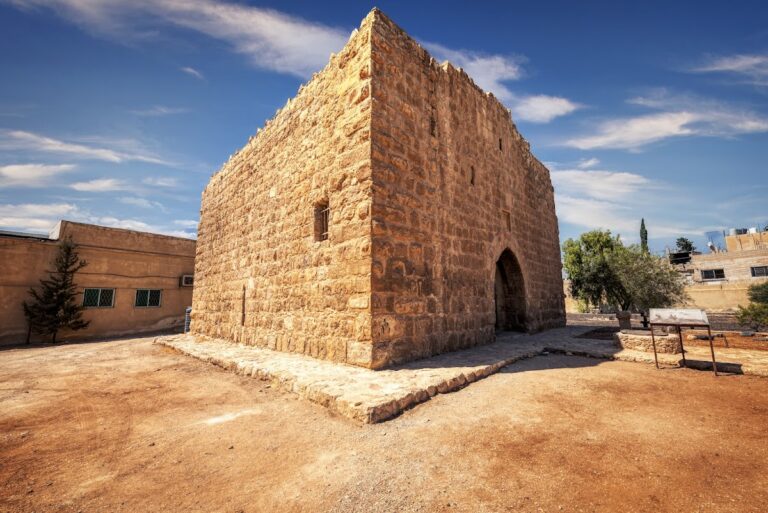
Qasr Kharana occupies about 1,225 square metres on a slight rise roughly 15 metres above the surrounding desert, along a ridge overlooking Wadi al-Kharana. It is a nearly square, two-storey building measuring about 35 metres on each side. Rough limestone blocks set in mud-based mortar form the walls. Courses of flat stones run through the outer facing and create a zigzag pattern along the upper third of the exterior.
Three-quarter-round buttresses reinforce the corners, while half-round buttresses divide the other facades. On the south side, a projecting rounded entrance is framed by quarter-round buttresses. This southern entrance provides the complex’s only entry. The structure combines a Syrian plan with Sasanian construction methods and influences from Parthian, Byzantine, Roman, and early Islamic traditions.
Entrance and Courtyard
Entrance Passage
The entrance opens into a passage approximately 3.5 metres wide and 9.15 metres long. Larger halls, each about 12.8 by 8 metres, flank the passage. Pillars divide these halls into two areas that were probably used for stabling and storage. Two vaulted chambers also stand beside the entrance hall.
Central Courtyard
The passage leads to a central courtyard measuring approximately 12.65 by 12.95 metres. A rainwater pool occupies its centre. Sixty rooms surround the courtyard on two levels, and rooms adjoining it open directly onto the shared space. This arrangement grouped separate residential or functional units, known as bayts, around a common courtyard. The east and west sides each contain an eight-room bayt arrangement, while the north side has a seven-room suite.
Rooms and Upper Floor
Ground-Floor Rooms
Many rooms contain narrow openings set high in the walls. Their irregular form and elevated position indicate that they admitted light and circulated air rather than serving as arrow slits. Air passing through the restricted openings created pressure changes and increased airflow, an effect known as the Venturi effect, helping to cool the rooms and regulate dust and light.
The interior walls include pilasters, medallions, blind niches, and plaster decoration, particularly on the upper floor. Some niches were finished with high-fired gypsum. Surviving stucco has played an important part in discussions of the building’s date and its connections with Sasanian and other architectural traditions.
Upper-Floor Apartments
The upper floor broadly follows the ground-floor arrangement, although its rooms vary in orientation and size. Two five-room bayts occupy the southern corners, with a large central room between them. A north terrace separated two apartments, while the arrangement of smaller exterior openings and larger inward-facing windows distinguished more private spaces from areas reached through the courtyard. One southern room was set aside for prayer.
Two staircases rise from the southwest and southeast corners of the courtyard. Each has two flights separated by a small landing. At the top, three doorways lead respectively to the upper-floor portico, the rooms, and a corridor containing stairs to the roof terrace. Traces on the eastern and western sides of the courtyard suggest that stone access structures to the upper floor may once have existed on all four sides. Wall settings along the north and south sides indicate that two wooden roofs formerly stood there.
Construction and Water Supply
The building’s structural system uses transverse arches to support barrel vaults, following Sasanian practice. At Qasr Kharana, the arches rest on bearing arms rather than being directly joined to the load-bearing walls. The weight of the structure holds these elements together. Wooden lintels and later materials added flexibility and helped the building resist earthquake movement.
Wadi al-Kharana supplied the complex through thamail, pits dug into gravel over the wadi’s bedrock. The pits retained water after the wadi flowed through the channel, although periodic floods could wash them away. The surviving installations are considered probably comparable to those used in the early Islamic period. The building’s name appears in several Latin-script forms, including Qasr al-Harrana, Qasr Harrana, Qasr al-Haranah, Haraneh, Hraneh, Qasr al-Kharana, and Khauranee.