Las Cogotas: A Fortified Iron Age Settlement in Ávila
Site at a Glance
- Popularity
- High
- Country
- Spain
- Primary era
- Iron Age
- Eras represented
- Iron Age
- Civilizations
- Celtic
- Site type
- Military
- Remains
- Fortified Town
On this page20 sections
History
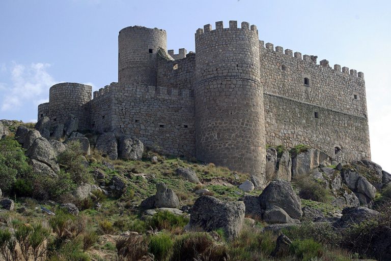
Las Cogotas is a fortified settlement near Cardeñosa in Ávila, Spain, whose principal Iron Age occupation is associated with the Vettones, a Celtic people of the western Iberian Peninsula. Its occupation sequence includes a Late Bronze Age horizon and a later horizon from the beginning of the Second Iron Age, separated by a gap. Research at the site has helped explain life in the Iberian Peninsula before the Roman invasion.
Bronze Age and Iron Age occupation
Archaeologists use the labels Cogotas I and Cogotas II for the two main occupation horizons at Las Cogotas: Cogotas I relates to the Late Bronze Age, while Cogotas II belongs to the beginning of the Second Iron Age. Pottery from the upper fortified area also points to a smaller, earlier Bronze Age occupation. The Iron Age settlement is an important archaeological reference for the Vettones, whose communities occupied parts of present-day Ávila, Salamanca, Toledo, Zamora and Cáceres, as well as Portugal’s Trás-os-Montes region.
Enclosures and proposed chronology
The proposed chronology assigns the upper enclosure to around the fourth century BCE, although its date remains uncertain. The lower enclosure and pottery workshop are placed in the third to second centuries BCE. Finds associated with the lower enclosure, including wheel-thrown pottery and horse-shaped brooches, support this dating. Other brooches have forms influenced by La Tène, a European Iron Age cultural tradition.
Cabré initially interpreted the lower enclosure as a cattle pen. Later investigations found houses and work areas within it, prompting the further possibility that livestock fairs were held there. The site’s cemetery was found during the 1930 excavation campaign and investigated again in 1931. Researchers have divided its grave groups differently: Cabré identified four zones, Guillermo Kurtz counted five plus one, and other interpretations favor four zones and a separate sector.
Excavations and conservation
Las Cogotas was known by 1876, and digging before the official excavations disturbed the site, with some materials lost or moved. Archaeologist Juan Cabré began official excavations in 1927, exposing the upper enclosure’s walls and examining 18 houses. In 1928, work surveyed the lower enclosure’s defenses and investigated houses near its northern entrance. Excavations in 1930 focused on establishing the settlement’s chronology and uncovered the cemetery. On 3 June 1931, Las Cogotas was declared an archaeological zone.
A dam project approved in 1983 placed its left abutment and spillway on the hill’s eastern slope. At the reservoir’s maximum level, water would cover about 30 percent of the area Cabré had identified as a cattle enclosure. In 1984, a cultural-heritage allocation was directed toward reducing the effects on the archaeological remains. Rescue work began in 1985 with a survey led by María Paz García-Gelabert. A geophysical survey the following year proved unreliable because of the granite ground and steep slope. Systematic excavations began that September, led by Gonzalo Ruiz Zapatero with a team from the Complutense University of Madrid and the Ávila Museum. The work aimed to record and protect remains, reassess earlier excavations and improve understanding of the site. Test excavations between 1989 and 1992 revealed houses in the lower enclosure.
Remains
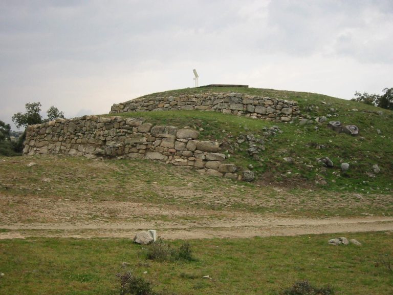
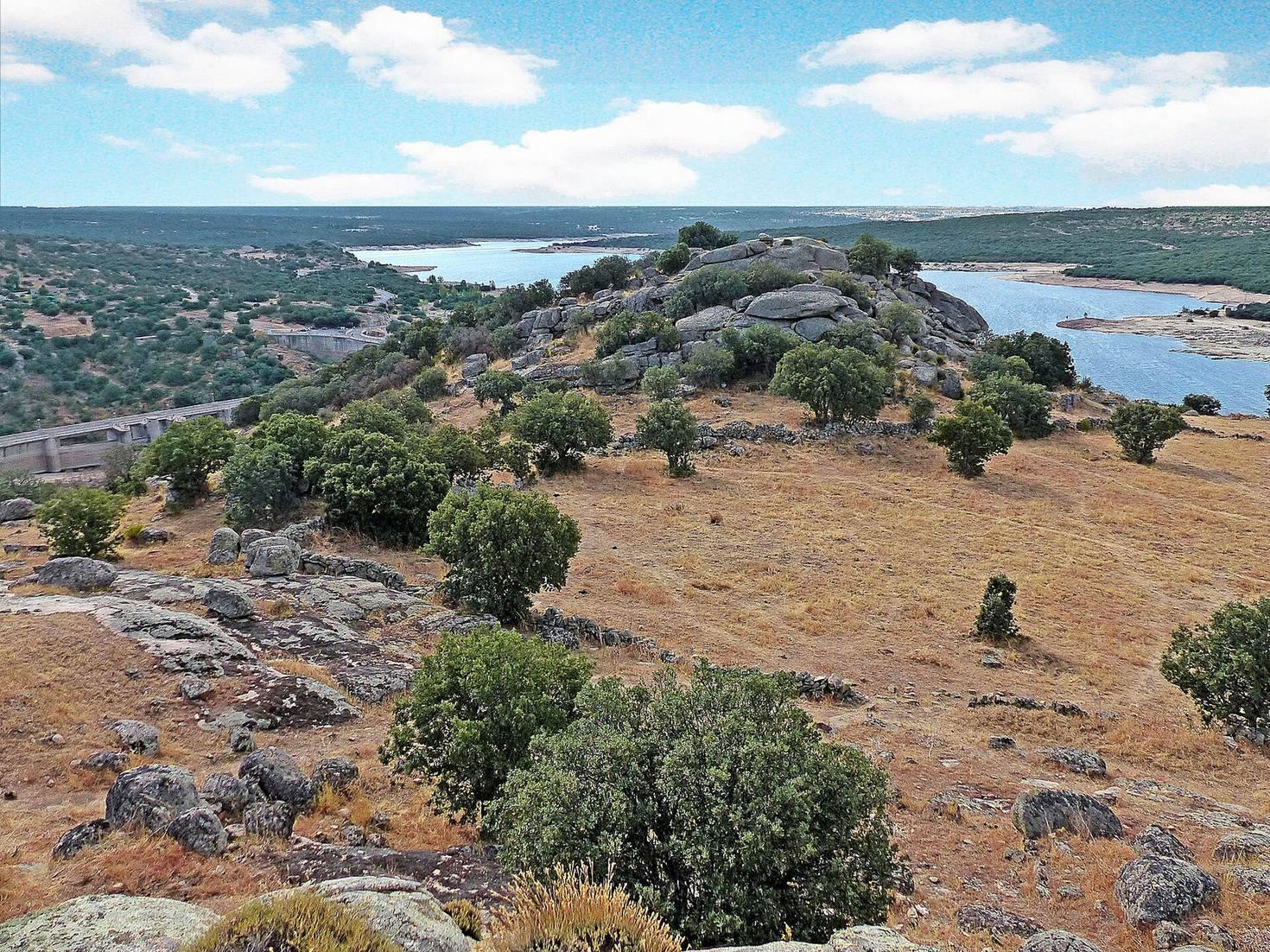
The 14.5-hectare settlement occupies a hill at the eastern end of a Sierra de Ávila spur, beside the Adaja River and about six kilometres southwest of Cardeñosa. Its summit reaches 1,156 metres above sea level, roughly 140 metres above the river. Two granite-built enclosures define the site: the upper enclosure, or acropolis (the fortified area at the summit), occupies the hilltop, while the lower enclosure descends south and west toward the Rominillas stream. The walls enclose an area with maximum dimensions of about 455 by slightly more than 310 metres. Within them, irregular groups of houses, open paths and paved routes occupy the available ground.
Fortifications and entrances
Walls and their setting
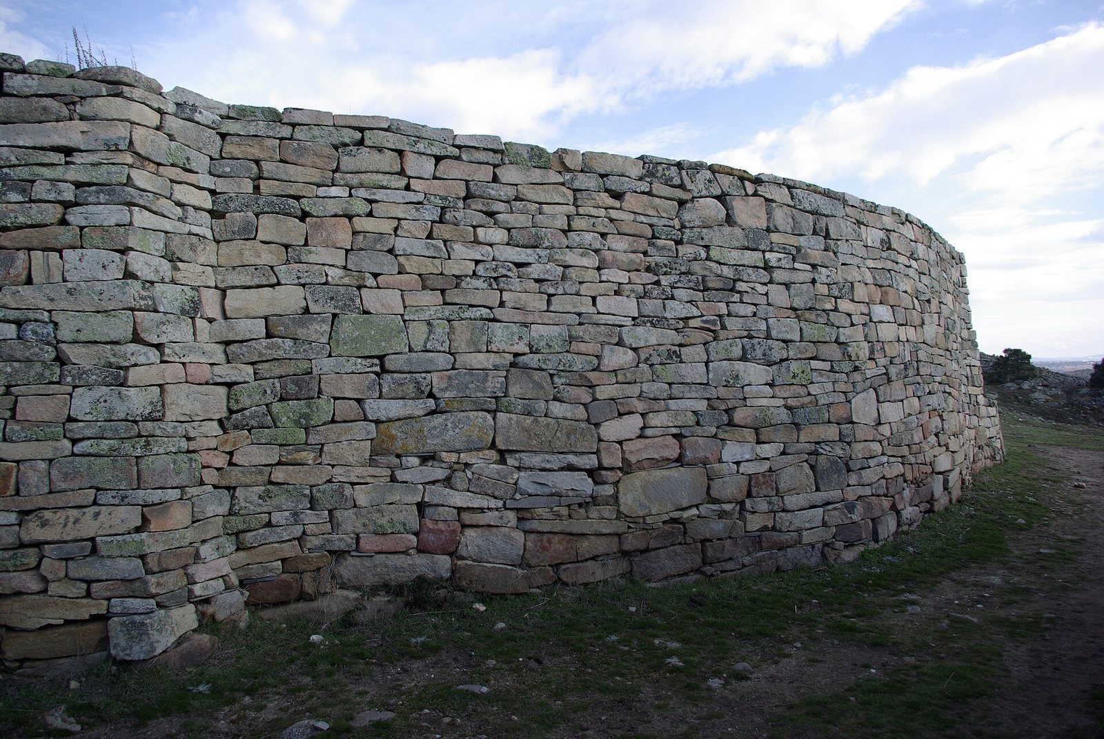
The walls consist mainly of granite slabs, cobbles and boulders laid in dry masonry, stonework assembled without mortar, with small stones packed into the gaps. Two outer faces enclose a core of rubble and slabs, and the foundations include adobe, or sun-dried mud brick. Wall thickness ranges from about 2.5 to 11 metres. The wall line bends and undulates, with large bastions, projecting defensive sections that could support flanking fire and strengthen the structure. In some places the defenses cross slopes; elsewhere they use or go around rocky outcrops. Interpretations differ over how closely the wall line follows the natural contours. A wall-top walkway is known near the main entrance and may have extended around the upper enclosure. Timber poles and branches, or an adobe upper structure, may have stood above the walls, particularly over the entrances.
Upper enclosure entrances
The principal entrance faces north and approaches the wall at an angle through a slightly narrowing opening flanked by two bastions. Upright granite slabs once bordered the path leading to it. Beside the approach, Cabré interpreted the remains of a rectangular structure as a guard post. Within the enclosure, a ramp ran over Houses 5 and 6 toward the upper fortification. A second, higher northern entrance was protected by two projecting towers. An eastern entrance connected the upper enclosure with houses on the slope outside the walls.
Lower enclosure entrances
The three documented lower-enclosure entrances are simpler and lack bastions. The northern entrance is about 10 metres from the upper enclosure’s main entrance. Another opens onto a northeastern terrace, while an entrance on the opposite side leads toward the Adaja; paving stones mark that route. Cabré also proposed a possible fourth opening on the southern slope, associated with an outlying neighborhood in a hollow and a path leading east.
Stone barriers and terraced space
At two accessible approaches, closely spaced, pointed granite stones formed barriers about three metres wide. One stood before the pair of ramps at the upper enclosure’s higher entrance; another occupied the hollow before the lower enclosure’s eastern entrance. Along the northern wall, the stones extended to its base. Their purpose is debated: they may have hindered cavalry or obstructed attackers on foot more generally.
A small, terraced enclosure between the two main enclosures was identified by Cabré and is now difficult to distinguish. Its position near the principal entrance, and its visibility from there, have prompted the suggestion that it served as a communal livestock pen.
Houses and paths
Upper enclosure houses
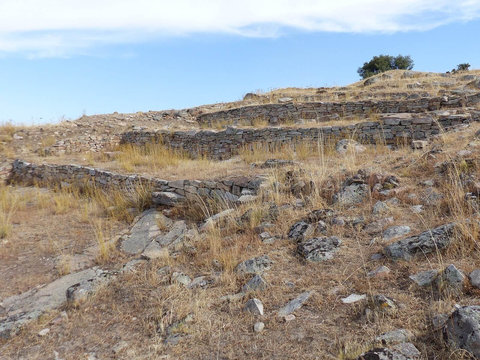
In the upper enclosure, rectangular houses were outlined with granite blocks and built on adobe foundations. They stood on artificial masonry terraces, whose surfaces remain more apparent than the terrace structures themselves. Some houses measured about 30 by 7 metres, or roughly 200 square metres. Cabré excavated houses that he did not all plot on his plans; his records indicate about seven additional buildings.
Lower-slope and outlying houses
Houses in the lower enclosure stood on a gentler slope between the steeper ground by the wall and a route crossing the settlement. Their plans are regular, with stone walls raised using adobe, and they are smaller than the houses in the upper enclosure. Other houses were recorded near the lower enclosure’s southern exit and on the southeastern slope. Their furnishings were poorer than those from the upper enclosure.
House interiors and circulation
House interiors are understood only in part. The quantity of adobe may indicate that some buildings had internal partitions. Floors followed uneven, sloping ground and were surfaced with granite slabs; a clay surface in a corner commonly formed a hearth. Fired clay with impressions from cylindrical wooden posts suggests roofs supported by posts and covered with straw or mud. Open spaces between house groups served as paths, sometimes edged with upright stones. A paved route crosses the lower enclosure beside work areas and continues toward the Adaja. Also known as the path to Uncle Juan’s mill, it was protected during work related to the dam. It may have carried carts distributing pottery.
Pottery production and refuse
Workshop and drying area
About 100 metres from the lower enclosure’s southern entrance, beside its wall, excavations revealed a pottery workshop and an area for drying adobe. The workshop covers more than 300 square metres and contains several rooms and simple kilns, each with a single chamber. Its foundation level aligns with that of the enclosure wall. A large adjoining room probably served to store finished goods and dry adobe; it contained mould-made units measuring 40 by 20 by 10 centimetres.
Refuse deposit
A test excavation beside the northern wall uncovered a refuse deposit more than three metres deep. It contained abundant animal bones and wheel-thrown pottery, along with smaller quantities of adobe and building material.
Cemetery and cremation area
Burial ground
The cemetery lies 240 metres north of the settlement on a small slope facing east. Groups of graves descend from north to south, with stretches of ground separating them. The cemetery contains 1,613 graves, of which 1,447 were studied; 224 of those, or 15.5 percent, contained grave goods. Cremated remains were placed in urns set in pits and steadied with small stones. An urn might be covered by a flat slab and smaller stones, or by an inverted plate or bowl, before the pit was covered with soil. When a burial included weapons, these and other larger objects lay around or above the urn without a fixed arrangement. Smaller objects, such as brooches, balls, spindle whorls and small vessels, were commonly placed inside with the ashes. Differences in grave depth may reflect a vertical sequence as well as the cemetery’s arrangement across the slope, although Cabré considered urns found at different heights to be contemporary.
Probable cremation surfaces
Broad, flat granite shelves without soil lie northeast of the settlement, between it and the cemetery. They were probably used for funeral cremations. Calcined bones, pottery fragments and bronze or iron slag were found around them. The metal debris came from grave goods associated with the deceased.