Fort of Salses: A Spanish Frontier Fortress in France



Site at a Glance
- Rating
- 4.5
- Popularity
- Medium
- Country
- France
- Primary era
- Early Modern
- External website
- Open
- Eras represented
- Early Modern
- Civilizations
- French, Spanish
- Site type
- Military
- Remains
- Fort
On this page17 sections
History
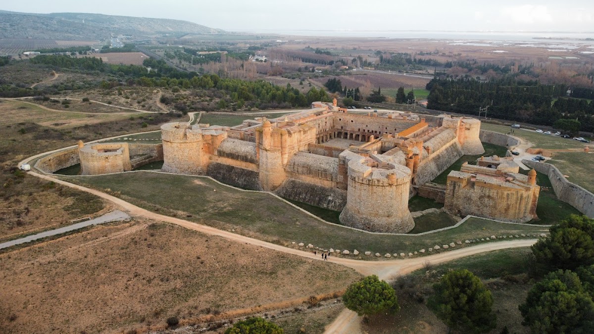
The Fort of Salses in France is a Spanish frontier fortress built between 1497 and 1504 for Ferdinand II of Aragon and Isabella of Castile, the Catholic Monarchs. It was constructed after the French army destroyed the village and castle of Salses in 1496, and was designed to defend the former boundary between Catalonia and France. Its semi-subterranean design belongs to a transitional period between the medieval castle and the bastioned fortifications developing in the early sixteenth century.
Foundation and Spanish frontier defence
The Catholic Monarchs placed the fort at the narrow Salses passage between the maritime Corbières and the Étang de Leucate. This corridor was an obligatory route for heavy artillery, wagons, supplies, and armies travelling from Languedoc towards Roussillon and Catalonia. Salses therefore functioned both as a barrier against invasion and as a base from which military operations could be launched. It faced the French fortress of Leucate, which has since been destroyed, and continued an older route system associated with the nearby Via Domitia and later with the roads and railway linking Narbonne and Port-Bou.
Construction was directed by the engineer Francisco Ramiro Lopez together with Commander Ramírez, described as the king’s chief artilleryman. The main works were completed in 1503, while further construction and changes continued into 1504. Before the fort was finished, French forces serving Louis XII attacked it. The garrison resisted the siege in 1503, during which an explosion in a mined defensive work caused several hundred casualties. About 600 French soldiers may have been killed or wounded. The explosion may have taken place at an earlier barbican protecting a second entrance, whose position can still be traced through changes in the masonry of the northern curtain.
After the siege, the Spanish added a substantial sloping masonry base, or talus, around the foot of the curtains and towers. The alteration blocked the original low-level firing positions and turned the access corridor around the outer walls into listening and counter-mine galleries. Counter-mines were defensive tunnels used to detect, obstruct, or destroy passages dug beneath a fortification by attackers.
From imperial stronghold to obsolete fortress
Charles V, the Catholic Monarchs’ grandson and Holy Roman Emperor, visited Salses in 1538. The peace made between Charles V and Francis I in 1544 brought roughly a century of calm between France and Spain. During this period, however, the fort gradually lost its military advantage as newer bastioned fortifications developed in northern Italy. Their projecting platforms and interlocking lines of fire addressed some of the weaknesses inherent in Salses’s earlier design.
The fort returned to active warfare during the Thirty Years’ War, the major European conflict fought from 1618 to 1648. It was besieged in 1639, 1640, and 1642. On 20 July 1639, after forty days of resistance, French troops commanded by Henri II de Bourbon, Prince of Condé, and Marshal Schomberg, governor of Languedoc, captured it. A French garrison of two regiments, numbering about 2,000 men under Roger de Bossost, Count of Espenan, then occupied the fort.
The new garrison was immediately threatened by a Spanish army about seven times larger. The siege lasted from 1 September 1639 until 6 January 1640, when hunger forced the French defenders to surrender. France finally conquered Salses permanently on 5 September 1642. The Treaty of the Pyrenees, signed on 16 November 1659, ended the Franco-Spanish conflict and transferred Roussillon to France. With the frontier moved farther from the fort, its strategic importance declined.
Prison, storage complex, and protected monument
In 1682, Salses was converted into a prison and was used at different times as a state prison, including for people connected with the Affair of the Poisons during the reign of Louis XIV. It also served as a barracks for passing troops, a food and ammunition store, and a powder magazine. The keep became a powder magazine in 1817. A garrison occupied the fort again from 1793 to 1804, although its principal strategic military function had ended with the frontier changes of 1659.
During a visit to the fort, Vauban, the principal military engineer of Louis XIV and a leading designer of systematic bastioned fortifications, ordered the parapets lowered in 1691. He judged Salses militarily obsolete and recommended complete demolition, but the massive construction made this impractical. Further proposals to demolish the fort were made in 1685, 1718, and 1726.
The Fort of Salses became a French Monument historique in 1886. In 2018, the protected property was more precisely defined as the fort together with its complete defensive system. The Centre des monuments nationaux administers it, and the French Ministry of Culture is its owner.
Remains
The Fort of Salses occupies a rectangular plan approximately 115 metres long and 90 metres wide. Its broad, deep dry ditches bury much of the structure, so that only the upper portions of the towers and curtain walls rise above the surrounding ground. The fort is divided into two unequal parts by a wide internal ditch and a curtain wall with a projecting spur. The eastern part contains the main parade ground, troop accommodation, and stables, while the western part forms the reduit, an independent inner defence centred on the keep. A reduit is a final stronghold intended to continue the defence after an outer area has been taken.
Outer defences and ditch system
Ditches, glacis, and galleries
The surrounding ditches are about 12 to 15 metres wide, with floors level with the lowest rooms of the fort. Their form may reflect construction within a very large natural excavation. A stone drainage channel, known as a cunette, runs along the ditch floor and carries away storm water. Heavy rain can still turn the ditches into marshy ground. The ditches were designed with firing slits and posterns in the escarp and counterscarp, allowing defenders to attack troops from the rear. The escarp is the ditch side nearest the fort, while the counterscarp faces the attacker. Water occupied the ditches during the nineteenth century and caused serious damage to the masonry of the listening galleries.
The outer system also includes a glacis, a gently sloping area exposing attackers to defensive fire, together with a half-moon work, heavy gates, external loopholes, internal firing slits, defended passages, and small courtyards arranged for crossfire. The masonry talus added after the 1503 siege protects the base of the walls against mining. Around the fort and the bases of the towers, vaulted galleries with half-barrel ceilings served for listening and counter-mining. They contain a water channel, a drain, and numerous urinals.
Detached artillery towers
Three detached, horseshoe-shaped artillery towers stand in widened portions of the ditch to the northwest, east, and south. Each has a projecting masonry spur designed to deny attackers shelter in an angle concealed from the defenders’ fire. The towers also shield the main fortification. Vaulted, partly buried passages called caponnieres connect them with the main body of the fort. In Salses, these passages contain firing embrasures for individual weapons and permitted protected movement and fire along the bottom of the ditch.
Corner towers and artillery positions
The four corner towers are circular. Those facing France rise approximately 21 metres and contain four internal levels of protected gun chambers, or casemates. The towers on the Spanish side are about 18 metres high and contain three levels. Their lower firing embrasures and sharply angled posterns were blocked by the post-1503 talus, whose construction produced the galleries around the foot of the fort.
Several metres of solid masonry separate the highest level of each tower from the lower chambers, protecting the upper positions from artillery. A central shaft in every tower served several purposes. It raised cannon, powder barrels, and shot, carried spoken orders between levels, and helped remove smoke from firearms and guns using black powder. The tower levels were connected horizontally through the adjoining barracks rather than by internal staircases.
The fort’s artillery consisted of 24 cannon. Large-calibre guns occupied platforms at the tops of the towers, while other weapons fired from the towers and from raised platforms called cavaliers. The present artillery platforms are later alterations. A drawing made by Francisco de Ollanda in 1538 shows the original towers with crenellated parapets carried on false machicolations and topped by projecting sentry turrets.
Entrance and internal circulation
Entrance complex
The entrance was protected by a sequence of controlled obstacles. Access involved crossing a fixed bridge, passing through a barbican, crossing a drawbridge with lifting arms, entering the half-moon work, following a bent passage, crossing a second fixed bridge, and reaching the gatehouse. Beyond the gate, doors, vestibules, and corridors formed a maze leading to the parade ground. Their arrangement exposed an attacker to several firing positions while restricting movement through the entrance.
The exterior of the gatehouse is mainly ornamental. Two cylindrical towers of solid Catalan brick frame a terrace above the gateway. Between them, a slightly recessed stone relief beneath a basket-handle arch carries arms possibly associated with the Catholic Monarchs.
Keep and final refuge
The Tour de l’Hommage, the keep and final refuge, has a rectangular side facing the courtyard and a semi-circular side facing the countryside and France. Its exceptionally thick, windowless outer wall forms a shield against artillery. The keep contains seven levels separated by strong floors, and its upper terrace rests on a massive vault approximately 26 metres above the ground. Historical drawings and engravings preserve the appearance of a watch turret that originally stood on the terrace.
The keep housed the governor’s office, officers’ quarters, and administrative rooms. Its three principal residential levels contain fireplaces, sinks, latrines connected to a sewer system, points for drawing water, alcoves, cupboards, and windows with lateral stone benches. Firing embrasures and internal communication routes are integrated into the residential spaces.
Reduit and parade-ground buildings
Inner defensive core
The reduit is separated from the parade-ground area by its own ditch and an unfinished rampart. Its principal connection with the parade ground was a heavily controlled bridge, probably originally a drawbridge. The interior courtyard of the reduit is surrounded by rooms serving the fort’s vital functions. Along its western side are powder magazines, a prison, food and flour stores, and a bakery with ovens.
A room in the northwest corner contains water basins and channels fitted with sliding controls for collecting and distributing spring water. On the eastern side, a building and ditch separate the reduit from the main courtyard. The building has a projecting spur and contains a large stable or sheepfold, an interpretation that remains uncertain, as well as a kitchen or dairy with a monumental fireplace, stone sinks, and a firing embrasure.
Parade ground, chapel, and stables
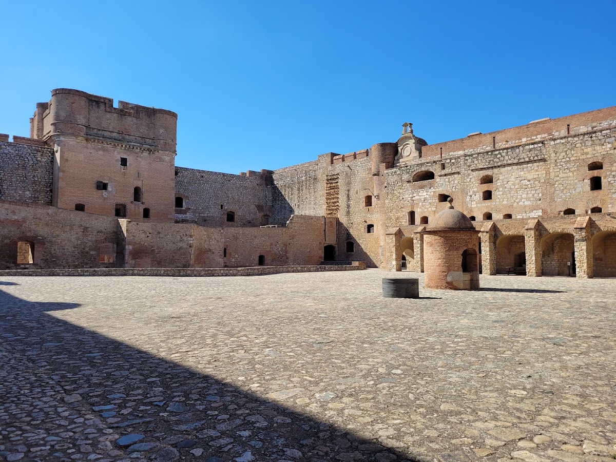
The main parade ground contains a central well reaching the water table approximately four metres below ground. It supplied people and horses. Fourteen other wells were used mainly to cool cannon. A portico with arcades borders the parade ground on three sides and provides access to the vaulted chapel and the stables.
The chapel occupies the eastern end of the parade-ground wing and is dedicated to Saint Sebastian. During the seventeenth century, it received an altarpiece with two pilasters, a moulded frame, and a pediment decorated with the royal sun emblem of Louis XIV.
The governor lived in the keep, officers occupied the northern and southern wings, and enlisted soldiers slept in dormitories above the stables. The stables extend around three sides of the courtyard and could accommodate up to 300 horses. Their mangers are cut into the foundation walls. Three levels of barracks above them could house up to 1,500 soldiers. These buildings are roofless and covered by slightly inward-sloping combat platforms, while the stables contain contemporary art exhibitions.
Later service buildings
A clock cage at the junction of the eastern artillery cavalier and the northern wing dates from the seventeenth century. The same corner contains three-seat latrines and a room that may have served as an infirmary.
Construction traditions and defensive design
The fort combines Spanish, Italian, and Burgundian building traditions. Spanish features include its complex internal circulation, the hierarchy of keep, reduit, and common courtyard, the use of brick in the upper works, and projecting sentry turrets. Italian influence appears in the east-west symmetry and the internal arrangement of the towers. Burgundian characteristics include the buried masses, detached advanced works linked by caponnieres, circular corner towers, and galleries along the escarps.
Its defensive system integrates compact outer volumes, numerous advanced works, and an extensive arrangement for collecting, storing, and using water. Water served domestic needs, hygiene, horses, cannon cooling, and the absorption of smoke from black-powder weapons. Approximately 400 external loopholes face the surrounding ground, while additional internal loopholes defend corridors, stairs, courtyards, and gates. The upper parapets of the keep, towers, and cavaliers contain seventeen broad cannon embrasures.
The buried construction reduced the attackers’ ability to damage the walls with metal shot, but it also limited the defenders’ fields of fire. The circular towers created angles that miners could exploit, while the escarps rose more than twice as high as the counterscarps, leaving over seven metres of wall exposed to artillery fire. The upper guns could not provide effective grazing fire across the glacis. The former secondary-entrance barbican has disappeared, while its position remains visible through the northern masonry alterations.