Citadel Cyriaksburg: Erfurt’s Former City Fortress


Site at a Glance
- Rating
- 4
- Popularity
- Very Low
- Country
- Germany
- Primary era
- Modern
- External website
- Open
- Eras represented
- Medieval, Early Modern, Modern
- Civilizations
- French, German, Holy Roman Empire, Kingdom of Prussia, Swedish
- Site type
- Military
- Remains
- Citadel
On this page23 sections
History
Citadel Cyriaksburg is a former city fortress in Germany, on Cyriaksberg in southwest Erfurt. The city of Erfurt began building it in the late fifteenth century, and it served as a fortification from the fifteenth to the nineteenth century. The site first belonged to the city, then came under Swedish, Electoral Mainz, and Prussian occupation or administration. Its position above the Gera valley and the roads toward Gotha and Nordhausen gave it an important role in Erfurt’s western defenses.
Early settlement and the Cyriaks Monastery
Cyriaksberg was probably inhabited by Stone Age communities around 5000 BC. A Benedictine nunnery was established on the hill in 1123. It had originally been founded around 743 beside Severikirche on Erfurt’s Domberg under the name St. Paul. Lack of space led to its transfer to Cyriaksberg under Adalbert I of Saarbrücken, the archbishop and elector of Mainz. The institution later became known as Cyriaks Monastery.
The hill became a military position during the late fourteenth-century conflict over the succession to the Mainz archbishopric. Erfurt supported Adolf of Nassau, while Pope Gregory XI and Emperor Charles IV supported a younger brother of Frederick the Strict, Landgrave of Thuringia. After the emperor placed Erfurt under an imperial ban, Thuringian forces besieged the city. They captured Cyriaksberg, used it to bombard Erfurt, and occupied the hill as a troop quarter. Peace was concluded in 1382.
The capture prompted Erfurt to strengthen its western defenses. The city built the Pförtchen Tower, later demolished in 1889, and the Brühl Tower, demolished in 1633. These measures preceded the decision to create a permanent fortress on Cyriaksberg.
Foundation of the city fortress
As Erfurt gained political independence while papal and imperial authority declined, its council decided to establish a fortress that could control the Gera valley and the routes toward Gotha and Nordhausen. The project required the Cyriaks Monastery to move for a second time. The pope authorized the plan in 1478, and Emperor Frederick III issued a building license on 14 May 1480.
The archbishop and elector of Mainz, Diether of Isenburg, and Ernest, elector of Saxony, opposed the project. They restricted Erfurt’s merchants from using trade routes outside Thuringia. After the death of William III, Duke of Saxony, an important protector of Erfurt, the city ended its resistance. The treaties of Amorbach and Weimar in 1483 made Erfurt recognize Mainz as its territorial lord and surrender money and territory to the Saxon princes. The opposing parties then accepted the construction of Cyriaksburg.
Financial obligations slowed the work. By 1488, only the foundations, the dry moat, and part of the western ring wall had been completed. Construction resumed fully in 1514. The two western towers and the fortress well were built between 1528 and 1530, and Cyriaksburg became part of Erfurt’s defensive system in 1530, staffed by a civic militia.
The original plan called for four towers, but financial constraints probably prevented the construction of the two eastern towers. The ring wall, fitted with loopholes and a protective tiled roof, was completed except on the eastern side in 1535. During the Schmalkaldic War of 1546 to 1547, troops under Maurice, Duke of Saxony, occupied the fortress after Erfurt refused them entry.
Swedish citadel and Electoral Mainz rule
In 1604, an eastern gorge building closed the fortress on that side. It served as the commandant’s house. Around the same time, the military regulations were revised to provide for a permanent garrison.
Swedish forces under Gustav II Adolf, the Swedish king who intervened in the Thirty Years’ War, occupied Erfurt and Cyriaksberg in 1631. During his visit to Erfurt on 24 September, Gustav II Adolf recognized the strategic value of the city and its defenses. He ordered Cyriaksburg to be expanded into a citadel under the fortress builder Casper Vogell and the engineer Otto von Guericke. The buildings provided quarters and a base for Swedish military campaigns.
In the final years of Swedish occupation, a ravelin, a detached triangular defensive work, was placed before each side of the fortress. A traverse, a defensive barrier used to shield troops or divide a position, was also built before each western tower.
The Peace of Westphalia in 1648 ended the Thirty Years’ War and required Erfurt, under older legal claims, to return to the Electorate of Mainz. Erfurt resisted because this threatened its municipal autonomy. Mainz and French troops forced the city to surrender in 1664 and occupied Cyriaksburg.
Johann Philipp von Schönborn, elector and archbishop of Mainz, considered modernizing the Cyriaksberg defenses, but priority went to the neighboring Citadel Petersberg. Cyriaksburg consequently lost much of its importance. Later additions included a cavalier, a raised artillery position, a two-storey barracks built in 1703, and a covered communication trench to Petersberg. A planned western hornwork was never constructed. In 1760, the high cost of repairs and changes in military technology led Erfurt to consider demolition, but Johann Friedrich Karl von Ostein, elector and archbishop of Mainz, rejected the proposal because the political situation remained uncertain.
Prussian and French occupation
Under the Prussian-French agreement of 1802, Prussia received Erfurt and the Eichsfeld as compensation for territories lost west of the Rhine. The Prussian Wartensleben Regiment No. 59 occupied Erfurt and Cyriaksberg and found the citadel neglected. Before and during the 1806 war between France and Prussia, Prussian forces added barracks and small palisaded tambours, or enclosed defensive works, in front of the gates.
After the battles of Jena and Auerstedt, Erfurt capitulated to Napoleon’s forces on 15 October 1806, and French troops occupied Cyriaksburg. During the early occupation, they concentrated less on improving the fortress than on selling valuable inventory.
The French also searched the walls for a legendary treasure supposedly hidden there from the time of the Cyriaks Monastery. Beginning on 9 December 1810, they partly dismantled the eastern and later the southern walls. Building documents showed that these sections dated from the seventeenth century and therefore could not have contained the supposed monastic treasure. The damage was extensive. Lacking funds for repairs, the authorities demolished the small fortress chapel and sold its stones and bricks.
Repairs resumed after the failed French campaign in Russia in 1812. They improved the glacis, a sloping earthwork leading up to a fortress, added bomb-resistant coverings to the towers, and constructed a covered route with a trench leading to Petersberg. Napoleon inspected Cyriaksburg on 6 April 1813 and was dissatisfied with the work. He ordered the Dreienbrunnen area to be cleared and flooded in summer 1813, but his plan to add four corner bastions was not carried out.
Siege and Prussian first-rank fortress
After the Battle of Leipzig from 16 to 19 October 1813, French troops withdrew toward Erfurt, where they planned to assemble and establish a center of resistance. Field Marshal Alexandre d’Alton directed the operation and began a blockade on 25 October by closing the city gates and shops. Within three days, a besieging force of 34,900 Prussian, Austrian, and Russian troops had surrounded Erfurt, with quarters and artillery positioned in the surrounding villages.
Prussian attacks on Cyriaksburg began in November 1813. The 800-man Napoleonic garrison initially repelled them. The French ended the city blockade on 6 January, then surrendered the citadel on 7 May 1814, after the fall of Paris on 31 March. Prussian troops took possession peacefully and found dilapidated buildings and a deteriorated arched wall.
Following the Congress of Vienna in 1814 and 1815, Erfurt became part of the Kingdom of Prussia. Together with Petersberg, Magdeburg, Wittenberg, and Torgau, the Erfurt fortifications helped secure the Prussian heartland in the Saxon-Thuringian region. From 1814, Prussia developed Erfurt and its two citadels as a first-rank fortress.
New Prussian modernization
In spring 1824, engineer captain Gottlieb Heise submitted designs for defensible barracks at Cyriaksburg. Later that year Johann Pientka, also known as Haak, became the engineer in charge at Erfurt, a position he held until 1837. Under his direction, Cyriaksburg was extensively enlarged and strengthened in the New Prussian system between 1824 and 1830.
The work deepened the moat and removed the interior buildings in 1824. Defensible barracks followed in 1825 and 1826. Cannon Courts I and II and Ditch Caponiers I and II, covered defensive structures projecting into the moat, were built in 1827. The counterscarp wall, the outer side of a ditch, corner batteries, side caponiers, the covered way, and the gorge caponier were completed in successive stages. The gorge caponier received two drawbridges, while the old fortress well was enclosed in an underground domed chamber.
In 1830, the earth cavalier was corrected and additional defensive spaces, a war latrine, and Hollow Traverse I were built. A peacetime powder magazine and terrace battery were added in 1842. The modernization ended after rifled artillery was introduced in the 1870s. Until then, the fortress was regarded as virtually impregnable. The 31st Infantry Regiment was stationed there from 1848, followed by the 1st and 2nd Magdeburg Fusilier Regiments No. 36 from 1871 to 1873.
Defortification and municipal transformation
After the foundation of the German Empire in 1871, the military importance of many fortresses declined. In 1873, Emperor Wilhelm I ordered Cyriaksburg to be defortified. The earth cavalier, complete ring wall, drawbridges, and tambours were demolished, and the eastern moats were filled.
From 1885, a local beautification association transformed part of Cyriaksberg into a landscape garden. A northern barracks was built in 1893 because the existing accommodation no longer met military needs. The fortress was considered for sale, but no sale took place. Troops, including parts of the 3rd Thuringian Infantry Regiment No. 71, continued to use the barracks until the end of the First World War.
In 1919, Erfurt purchased the entire Cyriaksberg from Prussia for 200,000 gold marks and converted it into a municipal garden. The southwest tower became a viewing tower in 1935. During the Second World War, the Wehrmacht placed anti-aircraft guns on the towers, while the fortress vaults served as air-raid shelters for Erfurt’s population.
Exhibitions, restoration, and the present site
During the period of the German Democratic Republic, the grounds around Cyriaksburg hosted horticultural exhibitions, including Erfurt Blooms in 1950 and the Seed Export Exhibition in 1955. The grounds and citadel courtyard were later developed as a cultural park, with an open-air stage in the former quarry. The northwest tower became an observatory.
Between 1958 and 1961, further development created the permanent International Horticultural Exhibition of the Socialist Countries. A horticultural museum and an extensive horticultural library were established in the defensible barracks.
After the political changes of 1989 and 1990, the former exhibition grounds became the present egapark Erfurt. Large-scale restoration of the surviving citadel buildings began in stages from 1995. Since May 2000, the defensible barracks have housed the German Horticultural Museum, which presents the history and practice of horticulture in approximately 1,500 square metres. The fortress well was made accessible, and the southern tower was converted into a viewing tower with a steel structure after being exposed in 1997. The surviving fortress and Cyriaksberg now form part of egapark Erfurt. Cyriaksburg is largely preserved as a city fortress of the seventeenth to nineteenth centuries, although it first operated independently and later became a detached work of Citadel Petersberg.
Remains
Cyriaksburg occupies the approximately 265-metre-high Cyriaksberg, an open elevation on a plateau west of Erfurt. The plateau slopes east and south toward the Gera valley and north toward the Schmira stream valley. The core fortress covers approximately 8,000 square metres and has an irregular quadrilateral plan. It was enclosed by a moat and covered way, with tambours dividing the moat into separate defensive sections. A double trench passage connected it with Citadel Petersberg.
Outer defenses and underground works
Tower redoubt and batteries
The fortress was originally surrounded by a horseshoe-shaped tower redoubt, two earthen corner batteries with traverses, and two side caponiers. Their purpose was to strengthen the western defenses. Lower levels of the tower redoubt and corner batteries connected with an underground counter-mine system, a network used to detect and obstruct enemy miners digging beneath the defenses.
The tower redoubt and both earthen corner batteries were demolished in 1925. The northern side caponier was demolished in the 1950s. A peacetime powder magazine and remains of the former terrace battery survive south of the citadel. The terrace battery defended the Gera valley and was later adapted as a viewing point.
Moat entrances and communication routes
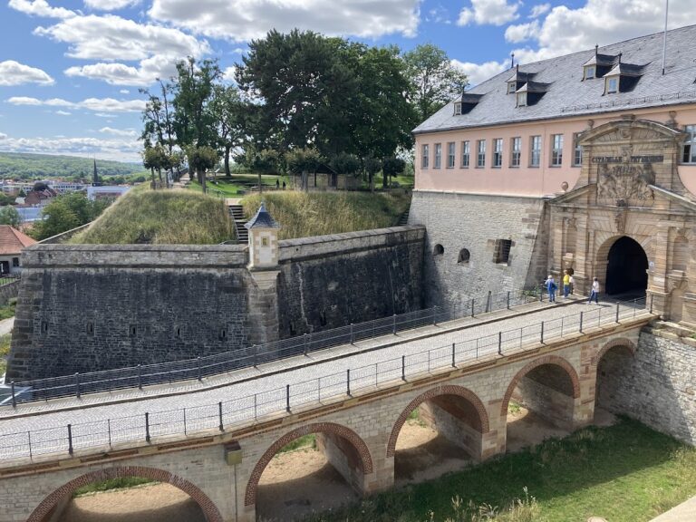
Before defortification, the only entrance to the interior led across a drawbridge and through the gorge caponier of the defensible barracks on the northeastern side. A forward tambour protected this approach. The gorge caponier had two drawbridges, while the side caponiers were associated with later corner batteries and counterscarp defenses. Their small gates and side walls helped divide the moat during an attack.
Defensible barracks and fortress well
Defensible barracks
The defensible barracks were built between 1824 and 1826 in the restrained architectural language associated with nineteenth-century Prussia, with eclectic elements drawn from more than one historical style. Cannon Courts I and II flank the building. Its courtyard-facing walls are reinforced and contain loopholes for artillery and infantry.
The ground floor originally held weapons and provisions stores, a wartime kitchen, and a fortress bakery. The two upper floors housed the garrison. Thick beams and an earth layer protected the roof against contemporary bombardment. The interior was divided into sections that could be separated by deployable palisade walls during an assault. Ground-floor connections led to an underground vaulted space containing the well installation and to the forward ditch caponiers and gorge caponier.
The building now contains the German Horticultural Museum. Its approximately 1,500 square metres present the history and practice of horticulture, continuing the building’s later role in the horticultural exhibitions and institutions established on Cyriaksberg.
Fortress well
The fortress well lies in an underground chamber with a domed vault and connects to the defensible barracks by a passage. A cistern with a capacity of 8 cubic metres supplied it. The well is described as approximately several tens of metres deep, and the installation has been made accessible.
Western gun towers
Tower A
The two gun towers on the southwest side of the core fortress rise approximately 15 metres and contain numerous loopholes. They were originally linked to the rest of the fortress by the ring wall. Tower A has a relief dated 1528 on its northern side. It shows the arms of Erfurt and of Kapellendorf, Vieselbach, Schlossvippach, and Vargula, villages then associated with Erfurt.
Tower A has housed an observatory since 1955. Its rotating dome has a diameter of 5 metres and was manufactured by VEB Carl Zeiss Jena. The lower levels were filled after defortification and exposed again during conservation work in the 1990s.
Tower B
Tower B has served as a viewing tower since 1935. Its lower levels were also filled after the fortress was defortified and were exposed again during conservation work in the 1990s. The southern fortress wall was partly reconstructed during the later conservation work.
Ring wall and interior courtyard
Ring wall
The former ring wall was approximately 400 metres long and about 3 metres high. Its upper edge had a sharply sloping roof intended to make it difficult for attackers to climb over. The 1535 wall contained loopholes and a tiled roof that protected the defenders and the masonry from the weather. On the northern and southern sides, the roof rested on several vaults, reducing the amount of building material required.
During the Swedish occupation, earth was packed against the inner faces of the ring walls. A stepped earthwork with palisades was placed in front of the moat, while ravelins were added before the sides of the fortress and traverses before the western towers. Much of this defensive arrangement was later removed during defortification.
Former cavalier and courtyard
The former castle courtyard lies between the defensible barracks and the gun towers. It originally contained a cavalier, a raised artillery earthwork higher than the surrounding defenses. Its internal cavities served as a wartime powder magazine and casemates, protected vaulted chambers used for military purposes.
A ramp on the cavalier’s northern flank allowed guns to be hauled upward. Hollow Traverse I stood in the middle of its front and contained loopholes. It connected through a stair tower and adjoining ditch caponier to the tower redoubt. The cavalier was dismantled during defortification. In the 1920s and 1950s, the former cavalier and courtyard were incorporated into the surrounding garden landscape.
Former chapel and quarry stage
The fortress chapel stood within the cavalier beside the barracks, well, and other protected structures. French forces demolished it during the occupation between 1810 and 1812, and its stones and bricks were sold. The former fortress quarry later became the site of an open-air stage when the surrounding grounds were developed as a cultural park.
Nearby sites