Arnsburg: A Medieval Hill Castle in Germany


Site at a Glance
- Rating
- 4.5
- Popularity
- Very Low
- Country
- Germany
- Primary era
- Medieval
- Eras represented
- Medieval
- Civilizations
- Holy Roman Empire
- Site type
- Military
- Remains
- Castle
On this page10 sections
History
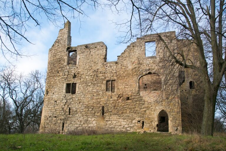
Arnsburg is a ruined hill castle in Germany, near Seega, first documented in 1116 when it probably served as an imperial castle during the conflict between Henry V, the German king and Holy Roman Emperor, and the Saxon princes. Henry of Meissen is said to have sought safety there. The castle may have been destroyed in 1118 along with the nearby Kyffhausen imperial castle.
Landgraves and Counts
At an uncertain date, Arnsburg appears to have entered the possession of the Landgraves of Thuringia. Their ministerial Ulrich of Arnsburg was recorded in 1229. Ministerials were administrative and military servants of powerful lords, some of whom rose into castle offices and the lower nobility. In 1278 and 1289, members of this group were described as castellans.
At the end of the thirteenth century, the Counts of Hohnstein expanded into the area. Albrecht II enfeoffed them with Arnsburg in 1293, meaning that he granted them the castle as a feudal holding. The Counts of Schwarzburg acquired it in 1356. In 1433, they granted the Counts of Stolberg a future claim to Arnsburg if the Schwarzburg line became extinct. The Schwarzburg counts later pledged the castle to the Lords of Vippach in 1498, by which time it appears to have been heavily deteriorated.
Destruction and Later Associations
Arnsburg was finally destroyed during the German Peasants’ War in 1525, a widespread uprising in which rural communities challenged feudal burdens and authority. The castle remained inhabited until 1547, but it was no longer mentioned after 1599.
A paper mill beside the Wipper below the castle was first recorded in 1478. It functioned as both a grain mill and a sawmill, while the administrative district of Arnsburg took its name from the castle. About 400 metres north-northwest, another fortification on the summit of the Schlossberg may be the Altenburg mentioned in 1505. It may also represent the original position of the Arnsburg recorded in 1116, with the castle later rebuilt farther south after its destruction.
Remains
Setting and Defences
The ruins stand about 1.5 kilometres southwest of Seega in Thuringia, on a slope above the Wipper’s breakthrough valley. Arnsburg occupies a small spur directed south-southeast, at about 293 metres above sea level. The castle area measures approximately 60 by 25 metres, while the Schlossberg rises northward to 353.7 metres. The northern approach was protected by a neck ditch and a second ditch-and-bank obstacle. Steep ground on the other sides was reinforced by a ring ditch with an outer bank.
Bergfried and Ring Wall
A round bergfried, the principal defensive tower of a medieval German castle, stood at the highest point of the site, north of the neck ditch. Dated to the second half of the twelfth century, it had a diameter of about 10 metres. Only a buried stump survives. A ring wall ran between the tower and the neck ditch, and parts of it remain up to 2 metres high.
Courtyard and Residential Buildings
Buildings once enclosed a central courtyard, with limited remains surviving from most of them. The east wing preserves three pointed-arch arcades, originally four, running parallel to the ring wall. Their close resemblance to the arcades of the palas at Straußberg Castle, the principal residential and representative building of a medieval castle, has led to their attribution to the Counts of Schwarzburg. The arcades were built at the end of the fourteenth century.
Principal Residential Building
The principal residential building occupied the southern side of the castle. Beneath it is a restored barrel-vaulted cellar measuring approximately 6 by 13 metres. The main cellar was reached from the courtyard through a vaulted passage. A second pointed-arch entrance leads to an ancillary cellar, which is now almost completely filled in. A reconstructed vault was shown at the site in 2025.
Entrance Area
The castle entrance may have stood on the eastern side at the level of the east wing. On the outer bank of the ring ditch, a surviving stretch of masonry may have served as an abutment for a drawbridge.
Related Fortification
On the opposite bank of the Wipper lies the Schwedenschanze fortification on the Konstein. It is attributed to the late Bronze Age and Iron Age, although medieval use is also possible.
Nearby sites