Archäologisches Freilichtmuseum Funkenburg: A Reconstructed Iron Age Fortification


Site at a Glance
- Rating
- 4.6
- Popularity
- Low
- Country
- Germany
- Primary era
- Iron Age
- External website
- Open
- Eras represented
- Iron Age
- Civilizations
- Unclassified
- Site type
- Military
- Remains
- Fortified Town
On this page11 sections
History
Archäologisches Freilichtmuseum Funkenburg is an open-air museum in Germany, at Westgreußen, presenting a reconstructed Iron Age fortified settlement occupied from about 200 BC to AD 50. The settlement was associated with a military leader, his retinue, and craftspeople, and reflects the period when iron tools and weapons were widely used in central Europe.
An Iron Age Settlement
The settlement belonged to a Germanic cultural setting. Here, “Germanic” describes groups associated with Germanic cultures and languages rather than a single unified state or people. Ceramic and other finds indicate the arrival of East Germanic groups and show contacts with Celtic communities and Rome.
Systematic excavations took place between 1974 and 1980. They identified 60 huts and approximately 500 pits, providing evidence for settlement organization and everyday activity. The largest building measured 8 by 14 metres and was probably the residence or meeting place of the settlement’s leader.
Reconstruction and Museum Development
After excavation, a section of rampart and ditch between the outer and main enclosures remained. A local group first rebuilt the defensive tower using simple methods. Posts then marked the approximate perimeter of the main building, encouraging a more complete reconstruction of the fortification.
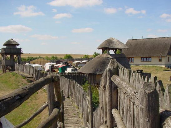
Between 1992 and 1999, the outer and main fortified areas were partly rebuilt on their original site with ramparts, ditches, towers, and palisades. The Funkenburg Westgreußen association developed the concept with scholarly advice from the Museum of Prehistory and Early History of Thuringia. The archaeological open-air museum opened in 2003.
Since the early 1990s, Funkenburg and the pottery workshop at Haarhausen have formed a center for experimental archaeology in Thuringia. Experimental archaeology recreates past technologies and activities to investigate how earlier communities may have built, produced, and worked. Association members demonstrate pottery-making, baking, spinning, dyeing, weaving, net-making, and archery as Iron Age activities.
Remains
The site occupies a flat spur on the outskirts of Westgreußen, approximately 175 metres above sea level. Steep slopes protect three sides, while the northwestern side was defended by a sequence of palisades, an outer rampart, a main rampart, and ditches. The surviving complex is a partial reconstruction of this hilltop fortification, arranged in an outer fortified area and a main fortified area.
Defensive Works
Ramparts and Ditches
The reconstructed defenses follow the original site and include an outer rampart, a main rampart, and ditches. These earthworks define the two fortified areas and reproduce the defensive arrangement identified through archaeological investigation.
Towers and Palisades
Reconstructed towers and palisades complete the defensive system. The first rebuilt tower formed an early stage in the local reconstruction effort, while the later work between 1992 and 1999 extended the recreated fortification across the outer and main enclosures.
Buildings and Working Areas
Residential and Work Buildings
The main fortified area contains recreated residential and work buildings. They represent the settlement’s occupied spaces and the activities carried out by its inhabitants, including craft production and domestic work.
Storage Buildings and Ovens
Storage buildings and ovens are also represented within the main fortified area. Together with recreated working implements, they show how food preparation, storage, and production formed part of life inside the fortification.
Leader’s Building
The largest building identified by excavation measured 8 by 14 metres and was probably connected with the settlement’s leader. Its reconstructed representation belongs to the selection of buildings used to explain the organization of the fortified settlement.
Nearby sites