Altes Schloss: A Medieval Castle Site near Mühltal, Germany


Site at a Glance
- Rating
- 3.5
- Popularity
- Very Low
- Country
- Germany
- Primary era
- Medieval
- Eras represented
- Medieval
- Civilizations
- Holy Roman Empire
- Site type
- Military
- Remains
- Castle
On this page10 sections
History
Altes Schloss is a probable medieval castle site in Germany, situated above present-day Nieder-Beerbach in Mühltal, Hesse. It may date from the end of the Early Middle Ages, perhaps the eleventh century, and has been associated with the Salian period, the rule of a medieval German dynasty during the eleventh and early twelfth centuries. Its exact foundation date, appearance, ownership, and original purpose remain uncertain.
Origins and possible functions
The site has been interpreted as a tower castle protected by an enclosing fortification, possibly centred on a raised mound carrying a tower or residence. Other interpretations propose a larger residential castle with several buildings. This has led to the possibility that Altes Schloss formed a complete castle complex and may have been an early predecessor of Frankenstein Castle, comparable in some respects with the Alte Burg in Nieder-Beerbach.
The surrounding land has long been known as Altes Schloss and has remained connected with a castle in local oral tradition. The 113-Morgen Bieberwoog, a mixed area of arable land, woodland, and meadow, formed its own judicial district. It may have been free land belonging to the abandoned castle. A description from 1597 placed the Bieberwoog outside any cent, a medieval judicial district, while the three nearby villages belonged to three separate judicial districts.
Medieval associations and later interpretations
This unusual legal arrangement may relate to a grant made by King Ruprecht I, also known as Rupert of the Palatinate, on 2 June 1402. The grant gave Nieder-Beerbach Castle and the Dörrenberg forest district imperial immediacy, a status placing a territory directly under the Holy Roman Emperor rather than an intermediate lord. The connection between this grant and the Bieberwoog remains uncertain.
Several wider theories about the Beerbach valley also remain unresolved. The castles below Frankenstein have been proposed as predecessor sites and possible early seats of the hypothetical Counts of Berbach. Another theory identifies the comes de Berebach as Carolingian counts of the Maingau. Nearby Schlösschen Ober-Beerbach has likewise been proposed as a predecessor of Altes Schloss, the Alte Burg, and Frankenstein Castle. These relationships cannot be established without further archaeological investigation. The site was once attributed to the Celts by the prehistorian Eduard Anthes, while later interpretations have placed it in the eleventh-century medieval castle tradition.
Finds, masonry, and excavation
A helmet discovered in the area in 1855 dates from the twelfth or thirteenth century. Known as the Frankenstein Helmet, it is held by the Hessian State Museum in Darmstadt.
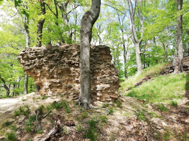
Around 1845, Heinrich Eduard Scriba, the pastor and local historian of Nieder-Beerbach, described masonry surviving at Altes Schloss. Farmers later removed wall material for building use. Excavations in 1976 uncovered foundation remains. Rainer Kunze proposed an eleventh-century origin and an enclosure formed by a ring ditch and two palisade rings, but the date and original function of the site remain unconfirmed. Investigations by Adam Breitwieser supported the possibility of a residential building and other structures in addition to a tower.
Remains
Mountain spur and earthworks
Altes Schloss occupies the tip of a long, narrow mountain spur about one kilometre south of Nieder-Beerbach, at roughly 290 metres above sea level. The spur extends from Adlerhöhe and falls steeply towards the Beerbach valley. The Beerbach borders it to the west, while two tributary streams from Bieberwoog Forest bound it to the east.
The principal surviving earthwork is an approximately oval, continuous castle rampart measuring about 60 by 35 metres. On the valley side, the rampart divides into terraces. A modern forest path cuts through it to the south and north-northeast, and another passage crosses the valley-side section towards the north-northeast. A neck ditch survives on the southern side, where the spur separates from higher ground. The ditch and the bank behind it remain faintly recognizable, while the proposed second palisade ring and the interpretation of the terraces as a fortified outer courtyard remain speculative.
Inner castle
Fortified house and residential tower
A large depression lies at the centre of the castle area. The foundation remains uncovered in 1976 have been interpreted as a fortified house or residential tower measuring about 10 by 15 metres, with walls approximately 2 metres thick. The remains lie within the inner castle area and consist largely of isolated loose stones, including stones worked on one face.
Central tower or representative building
Other interpretations identify the central structure as an approximately square defensive tower or small building. An adjoining depression has been understood either as a palas, the principal residential and representative building of a medieval castle, or as a structure resembling a bergfried, a strong main tower used for defence and refuge. The surviving masonry includes the western side of this feature, which has become covered again by leaves and soil.
Plant remains and nearby earthworks
Plants associated with former castle gardens include lesser celandine and club moss. A very old rose bush was also found, with strongly thorny stems, unscented flowers, and resistance to pests. Propagated plants from it survive in gardens in Nieder-Beerbach and in the Botanical Garden of the Technical University of Darmstadt.
Nearby Schlösschen Ober-Beerbach consists of an approximately rectangular ring rampart and ring ditch. Its relationship to Altes Schloss remains unresolved, and the area has alternatively been considered the site of an early or Celtic ring-wall installation.
Nearby sites