Alt-Thierstein Castle: A Medieval Fortress in Gipf-Oberfrick, Switzerland


Visitor Information
Google Rating: 4.6
Popularity: Low
Country: Switzerland
Civilization: Medieval European
Site type: Military
Remains: Castle
History
Alt-Thierstein Castle stands on a hillside in the municipality of Gipf-Oberfrick, Switzerland. It was constructed during the early Middle Ages, specifically in the early 11th century, by the local ruling family known as the Counts of Tierstein, a noble line later called the Counts of Homberg.
The castle is first clearly linked to Count Rudolf I, who used the name of the fortress in official documents from 1082 and again in 1114, suggesting its importance as a family stronghold. In the early 1100s, the Homberg family divided into two separate branches. One of these branches, led by Count Rudolf III of Homberg, established what became known as the Tierstein line, which took possession of Alt-Thierstein. Several centuries later, in the 14th century, this family line split again, passing the castle to a branch known as the Farnsburg lineage.
Toward the end of the 1200s, a new residence called Neu-Thierstein Castle was built near Büsserach, reflecting shifts within the family’s holdings. Nonetheless, Alt-Thierstein remained occupied well into the 1400s. Its abandonment seems connected with the end of the Tierstein-Farnsburger line, marking the conclusion of its active use as a noble estate.
In 1356, the castle endured the effects of a major earthquake centered near Basel. This tremor also destroyed Alt-Homburg Castle, a nearby fortress, but available records indicate that Alt-Thierstein sustained damage only and was repaired afterward, rather than suffering total collapse.
In the early 20th century, specifically 1934, an archaeological dig took place at the site under the direction of Hans Erb and his team. Unfortunately, documentation of the excavation was limited, and artifacts were later mixed together. This situation complicates detailed study of the finds today.
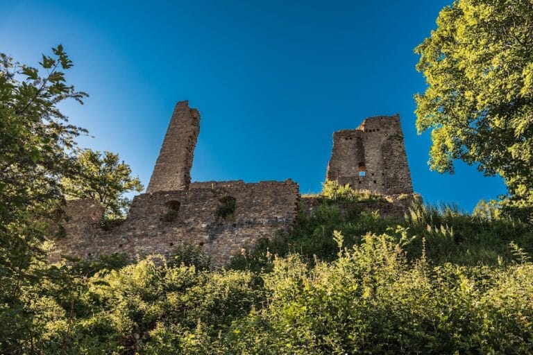
Remains
Alt-Thierstein Castle occupies a prominent position on the southeastern slope of the Tiersteinberg, a hill about 750 meters high near Gipf-Oberfrick. Instead of sitting on the summit, the fortress was built on a large rocky outcrop approximately 600 meters above sea level. This outcrop is composed of a substantial block of fallen rock that measures roughly 55 by 40 meters, providing a sturdy natural foundation for construction.
The castle’s building layout incorporated several terraces, which were carved into the steep hillside to create level platforms for structures. Each terrace was utilized by the builders, creating a stepped arrangement adapted to the natural slope and maximizing defensive advantage.
Over time, many stones from the castle walls were taken by local residents and reused for other construction projects nearby, a common fate for abandoned stone buildings. Nonetheless, the ruins still reveal the general extent of the fortress and its integration with the rocky terrain.
Surrounding the site are farm fields whose names preserve memory of the castle’s presence. These include places called “Burgmatte” and “Burghalde,” German terms meaning “castle meadow” and “castle slope,” which directly refer to the former stronghold’s location.
Although detailed architectural descriptions or measurements are not available from existing records, the overall preserved features allow a clear sense of a medieval hilltop castle shaped by both human effort and natural landscape.
Nearby sites