Münchsberg Ruins: A Medieval Hill Castle in Switzerland


Visitor Information
Google Rating: 4
Popularity: Very Low
Country: Switzerland
Civilization: Medieval European
Site type: Military
Remains: Castle
History
The ruins of Münchsberg are located near the municipality of Pfeffingen in Switzerland. This hill castle was erected in the second half of the 13th century by the noble Münch family, a prominent lineage within the Basel region during the medieval period.
Its founding was closely tied to the ambitions of Konrad III. Münch, who chose to build the castle not primarily to control the nearby mountain pass known as Plattenpass, but rather to curb the influence of the neighboring Schaler family. The Schalers held several castles in the vicinity, including Engenstein, Schalberg, and Frohberg, and the Münchs sought to assert their presence amidst these rival holdings. Originally, the Münch family served as ministeriales—unfree knights or servants—in the service of the Bishop of Basel. However, throughout the 13th century, they rose in prominence, eventually becoming one of the leading knightly families within the bishopric.
After establishing the castle, Konrad III.’s descendants began to carry the name “Münch von Münchsberg,” identifying themselves with their hilltop residence. In 1318, Konrad IV., son of Konrad III., enacted a strategic move by transferring ownership of the castle and its surrounding lands to the Bishop of Basel and then accepting them back as a fief. This process, common in medieval Europe, was intended to secure protection and reinforce ties to a more powerful lord.
The castle’s active use came to an abrupt downturn following the Basel earthquake of 1356, which caused significant damage to the structure. This natural disaster happened during a broader regional shift, as castles lost much of their political and military importance with the rise of fortified cities. Ownership of the fief passed to another branch of the Münch family, known as the “Münch von Landskron.” The last known member of this line, Hans Münch, died in 1459, after which control over the ruin transferred to the Rotberg family.
In the early 16th century, around 1515, the Rotbergs attempted to sell the Münchsberg estate to the city of Solothurn. The interest was mainly in the associated lands and rights rather than the already ruined castle itself. Initially, the Bishop of Basel blocked this sale, but it was eventually sanctioned roughly four decades later. The present-day location of Münchsberg within the canton of Basel-Landschaft reflects changes made to cantonal borders during the 19th century, when parts of the area were reassigned between Solothurn and Basel-Landschaft.
Remains
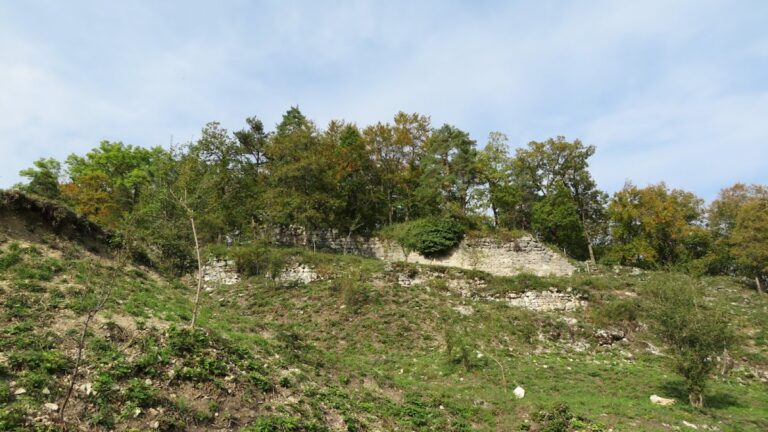
The Münchsberg ruins occupy a wooded ridge approximately 477 meters above the nearby Klusertal valley. The site overlooks a medieval traffic route leading toward the Plattenpass and is known for its challenging visibility during summer months due to dense forestation. Access to the ruins is provided by a footpath called the “Burgengratweg.”
The castle’s placement takes advantage of natural defenses: steep cliffs guard the northeast side, while the southwest and southeast sides are protected by a deepened ditch. This ditch was not entirely natural but enhanced by the castle’s builders, who used the excavated soil and rock to construct parts of the fortification.
What remains of the castle complex includes fragments of tower-like structures and a large surrounding defensive wall. The main area divides naturally into two sections separated by rock formations. On the southeastern section sits the largest surviving building, a residential structure measuring roughly 19 by 14 meters with walls up to three meters thick. This substantial building was likely the main living quarters. Nearby, scant traces suggest subsidiary buildings once attached to the residential tower, though these remains are too minimal to clarify their original design or function.
The northwestern part rests on another rocky outcrop containing at least three buildings, some almost square and measuring as much as 16 by 16 meters. Their purpose is uncertain due to the limited physical evidence, and details of their construction remain unclear.
South-east of the main gate, separated by a narrow neck ditch, lies a suspected outer bailey. This feature consists of an artificial mound over 15 by 15 meters in size, surrounded by a shallow ditch. Unlike the rest of the castle, no stone walls are associated with this mound, which may indicate an unfinished ancillary fortification or an outbuilding.
Together, these remnants reflect the castle’s medieval origins and the natural topography shaped and enhanced by human engineering, leaving behind a notable but fragmentary example of 13th-century hill castle construction.
Nearby sites