Gonfienti: An Etruscan City and Archaeological Site in Italy
Site at a Glance
- Popularity
- Medium
- Country
- Italy
- Primary era
- Iron Age
- Eras represented
- Iron Age, Classical
- Civilizations
- Etruscan, Roman
- Site type
- City
On this page18 sections
History
Bronze Age and Etruscan city
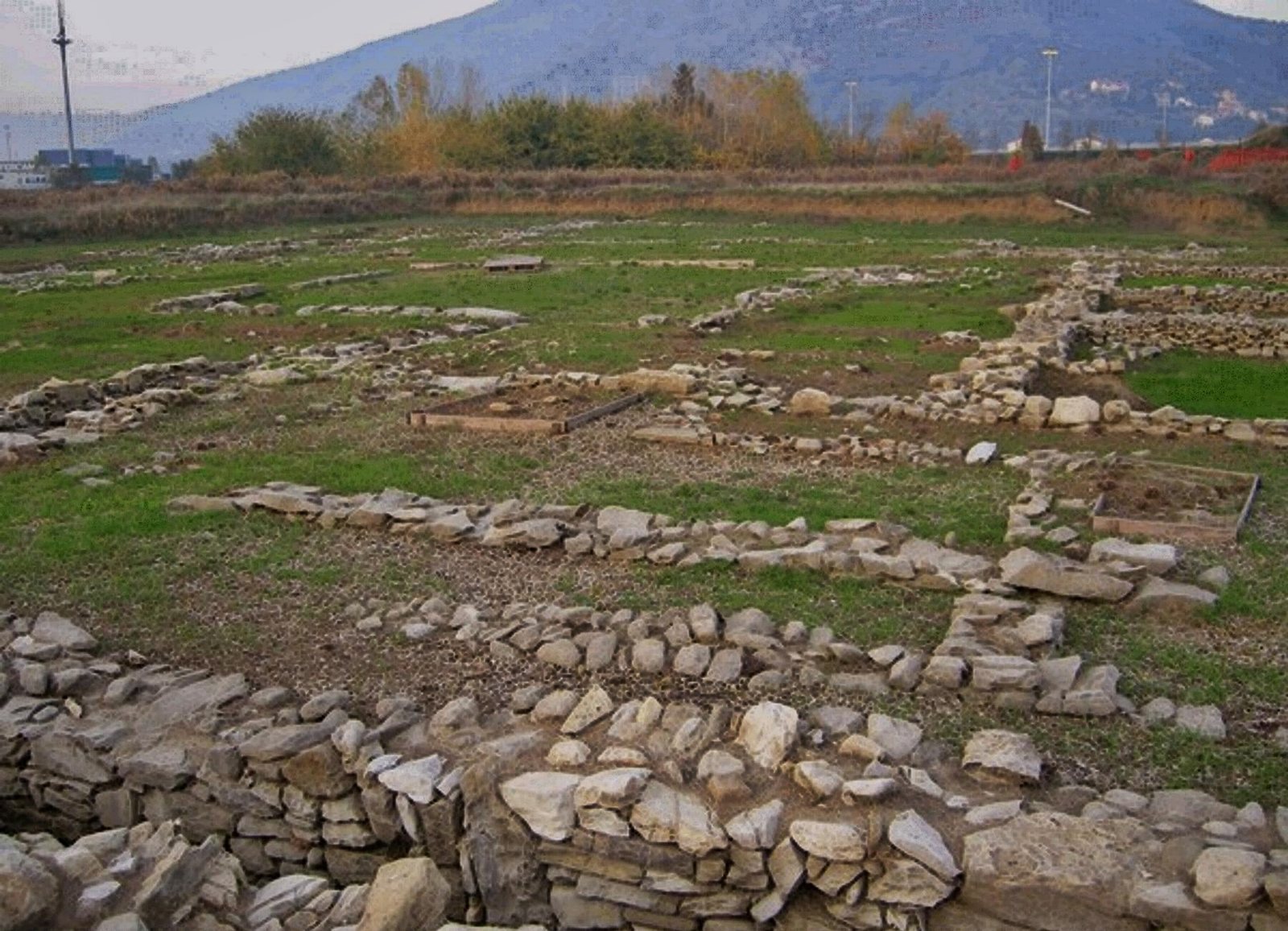
Gonfienti is the archaeological remains of a planned city founded by the Etruscans in the sixth century BC on the eastern outskirts of Prato, Italy, partly within Campi Bisenzio. The Etruscans were an ancient people of central Italy, and Gonfienti belonged to the archaic period, an early phase of Etruscan history. Its ancient name is unknown. A separate Middle Bronze Age village, from a prehistoric period several centuries earlier, stood a few hundred metres away.
The Etruscan settlement remained occupied from the sixth century until the last decades of the fifth century BC. Its position made it an important junction between central Etruria and routes running north across the Apennines to the Po Valley, especially to Marzabotto. The route linked the Arno valley with Etruscan centres to the north and formed part of the Etruscan iron route. Gonfienti is an important site for understanding Etruscan settlement north of the Arno and the connections that joined the area to the Po Valley in the late archaic period.
Across the region between the Arno, the Sieve valley and the Apennine passes, material culture from the mid-sixth to the fifth century BC had notable similarities. Shared ceramic forms are found at Gonfienti, Artimino, Sesto Fiorentino and Fiesole. Fiesole was a centre in the eastern part of the wider plain, while Gonfienti occupied a central position. Kilns at Carraia in the Marina valley also point to activity along one of the routes connecting the plain with centres beyond the Apennines.
Gonfienti’s right-angled street plan has been compared with that of Kainua, an Etruscan city near Marzabotto. The comparison shows that Marzabotto’s urban layout was not unique: similarly oriented plans existed on both sides of the Apennines in the sixth and fifth centuries BC. Whether this resemblance reflects a shared trans-Apennine design or standardized religious rules for founding cities remains debated. Some interpretations also connect the regular urban layout and the organization of its agricultural territory with coordinated political change, and see the plan as expressing a civic order based on shared community norms rather than the interests of individual aristocratic groups.
Abandonment and later occupation
The city was abandoned by the end of the fifth century BC, during a wider decline in population across the plain. A gradual increase in rainfall and destructive flooding is considered the most likely cause. The resulting wetland made the area less suitable for settlement. After about a century, occupation resumed from the end of the fourth century BC, beginning on the surrounding uplands. Magnetic properties preserved in a domestic furnace from the Interporto area place its firing most probably between 399 and 298 BC.
Romanization of the plain began in the second century BC as Rome fought its final wars against the Ligurians, an ancient people of northwestern Italy. At Gonfienti, Roman-period activity included renewed use of parts of the former Etruscan settlement, a small production area and burials dating to the early Roman Empire. The wider territory was crossed by the Via Cassia Clodia.
The medieval village of Gonfienti grew near the meeting of the Marinella and Bisenzio rivers. Its name derives from the Latin confluentes, meaning confluences, and belongs to the later village rather than to the Etruscan city. In 2004, Giuseppe Centauro proposed that the Etruscan settlement was Camars, a name associated in ancient writings with the city later called Clusium, or Chiusi. This identification, based on local place-names, has not been accepted in specialist scholarship.
Identification and archaeological protection
Ancient pottery fragments came to light during preventive excavations for a logistics platform in 1996. The Etruscan city was identified the following year during work on a water conduit for the developing Central Tuscany Interporto. From the second half of the 1990s, heritage authorities carried out extensive investigations to locate and protect archaeological areas. Excavations in lot 15F in 2000 and 2001 revealed buildings on both sides of a gravel road, confirming the settlement’s urban character. Work on the large residence in lot 14 began in the same period, continued regularly until 2009 and was followed by more targeted investigations.
In 2004, ground-penetrating radar surveys over about 27 hectares of potential settlement area were checked with roughly 60 test trenches. The work identified another settlement sector of about five hectares and natural gravel deposits that help reconstruct changes in the ancient course of the Bisenzio. Investigations from the late 1990s through 2004 had brought about 12 hectares under protection. The Italian state acquired a substantial part of the settlement land in 2017, and the area became a protected archaeological site.
Excavations resumed in 2020 and continued in the eastern area, lot 15F and area 21, with closer study of the courtyards and roads in lot 15F in 2022. The University of Florence also began investigating a building complex beside lot 14, in collaboration with the heritage authority and the university’s Etruscology chair. By 2025, this work had exposed a residential building of more than 400 square metres west of lot 14.
Remains
Setting, streets and drainage
The archaeological area lies beside the confluence of the Marinella and Bisenzio, at the foot of the Calvana mountains and on the edge of the Florence-Prato-Pistoia lake-and-river basin. At about 50 metres above sea level, the Etruscan city occupied an alluvial fan on the Bisenzio’s right bank, at the southern end of a valley route towards the Arno and the Apennines. Its planned area covered at least 27 hectares.
The settlement’s right-angled street plan adapted to the terrain and to water flowing from the Calvana towards the Bisenzio. Its main roads were about nine metres wide, surfaced with gravel and edged by drainage channels. A wider network of channels drained the settlement and helped protect it from floods. Buildings share orientations and construction practices. They commonly had drains around their outer walls, tiled roofs, a central courtyard and direct entrances from an internal road.
Flood deposits, locally between one and three metres thick, sealed archaeological structures. Their depth and distribution help explain how flooding altered the settlement area and its preservation.
Residential and open areas
Lot 14 residence
The large residence in lot 14, also called building 1, dates to the sixth century BC and covers about 1,400 square metres. Irregularly rectangular and aligned northeast to southwest, it occupied an entire block. Its rooms surrounded a square open courtyard, which had a portico resting on plinths. The roof sloped inward towards the courtyard, where figured roof ornaments decorated the space. A large banqueting room opened onto it, and fragments of fine Attic red-figure pottery were recovered from the room.
A well with a raised rim stood at the courtyard’s northwest corner. A deep drain ran around the building, whose entrance faced a street on the south side. In the western wing, abundant cooking-vessel fragments identify a kitchen beside a pantry with two large storage jars. The eastern wing included a bell-shaped oven beneath the floor of one room. Another room contained an inverted pot protected by fired clay, interpreted as a possible trace of domestic worship.
The northern wing, the part altered most extensively, was remodelled in Etruscan and Roman times. Two ancillary rooms outside the residence may have been used to store materials or keep animals. The building’s size and fine finds, including Attic pottery, indicate that its owners had high economic and social status.
Lot 15F
In the western settlement sector, buildings stood on both sides of a northeast-to-southwest gravel road. On its western side was a rectangular building with three rooms, an external courtyard and a well. A separate building on the eastern side had a quadrangular room. Beneath the principal structures, an earlier building phase dates to the end of the sixth or beginning of the fifth century BC.
Area 21
Area 21, east of lot 15F, contained a largely open surface dating to the fifth century BC. Wooden structures and other perishable materials were associated with it. This area provides evidence for organized open spaces alongside the settlement’s built-up areas.
Bronze Age and Roman-period remains
Bronze Age village
A few hundred metres from the Etruscan city, the Middle Bronze Age village was investigated across about 5,000 square metres. It is considered one of the largest settlements of its period in northern Tuscany.
Roman-period features
Roman-period remains include channels and road alignments in area 21 and near lot 14. Their arrangement is consistent with Roman centuriation, a surveyed system that divided farmland into regular plots. A ground surface in the area contains material dating as late as the imperial period, and some structures were laid out again over the former Etruscan settlement.
Finds, domestic life and roof decoration
Pottery and other objects
Domestic pottery includes coarse and fine plain wares, impasto pottery made from coarse clay, dark Etruscan bucchero, painted Etruscan-Po Valley wares and Attic pottery. Other finds include fragments of Corinthian amphorae, metalworking slag, Certosa-type clothing fasteners and aes rude, rough, unworked bronze used in early forms of exchange.
Locally made serving vessels
At least 75 locally made kyathoi, handled vessels for dipping or serving, were recovered. Most are bucchero, while others use coarse or refined clay. Their decoration ranges from stylized human figures to plant designs. Clay analyses, including the presence of diallage, a mineral that can help identify a clay’s source, support local manufacture. This vessel form is also found between the Arno and Sieve valleys, including at Fiesole, and reached an especially elaborate form at Gonfienti in the sixth and fifth centuries BC.
Household evidence
Animal bones from lot 14 indicate that residents relied chiefly on cattle, followed by domestic pigs, most of them slaughtered young. Sheep and goats were also kept, while deer, wild boar and hare added to the diet. Pathologies in adult animal bones suggest that livestock also provided labour, milk and wool. Meals were eaten in both the western and eastern wings, a pattern that may reflect differences in rank among the occupants. Numerous water-bird remains are consistent with the area’s extensive wetlands.
In a small cavity in the northern wing, an example of a locally made vessel had boar tusks inserted into its horn-shaped handles. It has been associated with possible domestic ritual. Attic red-figure and black-gloss pottery was present by the fifth century BC. A red-figure drinking cup attributed to Douris, an Attic vase painter active around 500 to 460 BC, or his workshop, was found in fragments in two parts of lot 14 and later reassembled.
Roof ornaments and museum display
Three finely made, locally produced roof ornaments of the late archaic period came from the roof collapse of the lot 14 building. Each depicts a female head identified as a maenad within a shell-shaped frame marked by radiating grooves. Since 2022, Gonfienti finds have been displayed at the Archaeological Museum of Gonfienti in the Rocca Strozzi at Campi Bisenzio. Its Etruscan display includes a case whose outline follows the plan of the lot 14 residence, a reassembled section of the building’s terracotta roof with tiles and curved tiles, female roof ornaments placed at portico corners, and the reassembled cup attributed to Douris.