Stelae of Nahr el-Kalb: A Multiperiod Record of Lebanon’s History
Site at a Glance
- Rating
- 4.2
- Popularity
- Very Low
- Country
- Lebanon
- Primary era
- Bronze Age
- External website
- Open
- Eras represented
- Stone Age, Bronze Age, Iron Age, Classical, Medieval, Modern
- Civilizations
- Assyrian, Babylonian, British, Byzantine, Egyptian, French, Mamluk, Ottoman, Roman
- Site type
- Civic
- Remains
- Monument
On this page16 sections
History
The stelae of Nahr el-Kalb are a group of more than 20 commemorative inscriptions and rock reliefs at the mouth of the Nahr el-Kalb, or Dog River, in Lebanon, north of Beirut. Created over successive periods from the Egyptian New Kingdom to the modern era, they occupy a strategic crossing on the eastern Mediterranean coastal road and have been described as a place where Lebanon’s history is concentrated in one landscape.
A strategic crossing and the Egyptian monuments
The Nahr el-Kalb cuts a deep gorge through the coastal mountains before reaching the Mediterranean. Its estuary provided one of the few practical crossings along the coastal route between northern Syria and the southern lands. Rulers, generals, and conquering armies used the cliffs beside this passage to commemorate their arrival, victories, engineering works, or claims to authority.
The earliest surviving inscriptions belong to the reign of Ramesses II, the pharaoh of Egypt’s Nineteenth Dynasty. His long rule included military campaigns and monument building in the Levant during the New Kingdom, the period of Egyptian imperial expansion conventionally dated to about 1550 to 1070 BC. Three hieroglyphic stelae bear his cartouche, the oval frame surrounding a pharaoh’s royal name.
At least one of these monuments was probably placed during Ramesses II’s first campaign in the Levant. It may have marked the Nahr el-Kalb as the boundary between the Egyptian province of Canaan and Hittite territory. Its worn text preserves the king’s name and the words “Year 4.” A southern stela belongs to his tenth regnal year, while the text of a northern example has been lost.
The monuments formed part of Ramesses II’s effort to consolidate Egyptian influence in Palestine and coastal Syria against the Hittites, an Anatolian kingdom that competed with Egypt for control of the Levant. This wider conflict included the Battle of Kadesh, fought around 1274 BC. The Egyptian presence also continued an earlier interest in the region, reflected in the autobiography of Weni from around 2280 BC and the Sebek-khu Stele from around 1860 BC.
Assyrian, Babylonian, Greek, and Roman claims
Six inscriptions in Assyrian and Babylonian cuneiform belong to the first millennium BC. The stele of the Assyrian king Esarhaddon commemorates his capture of Memphis from Taharqa, the Kushite pharaoh of Egypt, in 671 BC. It probably refers to Ashkelon, Tyre, Taharqa, and 22 vassal kings. Set above or near a relief of Ramesses II, it expressed Assyrian victory in a Phoenician region that had recently rebelled.
Another monument is attributed to Nebuchadnezzar II, the principal king of the Neo-Babylonian Empire, which ruled from 605 to 562 BC. It contains two cuneiform texts, one in Neo-Babylonian and one in Old Babylonian. Its royal imagery and strategic placement expressed Neo-Babylonian control of western territories and warned potential enemies. Other cuneiform reliefs may belong to additional Assyrian kings whose identities remain uncertain.
A plaster cast of an Assyrian inscription made by Joseph Bonomi the Younger in 1834 became the first artifact of the ancient Assyrian Empire brought to the United Kingdom. The Egyptian inscriptions, meanwhile, were first correctly identified by Karl Richard Lepsius. Earlier scholars, including Edward Robinson, had connected them incorrectly with Sesostris, the legendary Egyptian king mentioned by Herodotus.
Greek and Roman inscriptions record later road building and engineering. The most prominent Roman example is associated with the Legio III Gallica, a Roman legion, during the reign of the emperor Caracalla. Probably dating to around AD 215, it records the construction of the road through the site and uses the name “Lyco Flumen,” which led early scholars to identify the Nahr el-Kalb with the ancient Lycus River.
A partly readable Greek inscription commemorates road or other engineering work carried out in AD 382 under Proclus, the Byzantine governor of Phoenicia, during the reign of Theodosius I. Byzantine refers here to the eastern Roman imperial state and its institutions. Another Greek inscription has been uncertainly attributed to the Seleucid ruler Antiochus III and may relate to his victory in the Fifth Syrian War, a conflict between the Seleucid and Ptolemaic kingdoms over Coele-Syria and neighboring lands between 202 and 195 BC.
A Roman numeral inscription reading “CDIII” probably recorded the number of steps cleared by workers. A milestone that is now lost once marked the 221st mile from Antioch. It carried a dedication to Constantine and three Caesars, dated to AD 333 to 335, and had been engraved over an older inscription.
Medieval and Ottoman interventions
Two medieval Arabic inscriptions record repairs to bridges. One was made under Barquq, a Mamluk sultan of Egypt and Syria from the Burji dynasty. It commemorated the repair of a bridge and warned that an unjust toll collector would suffer the curse of God, the angels, and the people. Another inscription commemorated bridge repairs under Fakhr-al-Din II, a Druze emir who ruled much of Mount Lebanon in the late sixteenth and early seventeenth centuries. Henry Maundrell recorded it in 1697, but it was no longer legible by the nineteenth century.
Napoleon III’s inscription commemorates the French military intervention in Lebanon during the 1860 conflict between Druze and Maronite communities. The inscription was probably cut over one of the Ramesses II stelae, destroying its earlier text. The French historian Ernest Renan reportedly observed its creation. Military structures built on the summit of the promontory in 1840 during the Second Ottoman-Egyptian War added another later layer to the site.
Two identical inscriptions from 1901 commemorate the construction of a new Ottoman bridge under Sultan Abdul Hamid II. One was written in Arabic script and the other in Ottoman Turkish script. Their paired form continued the practice of using the crossing and its cliffs to associate public works with political authority.
War, mandate, independence, and modern commemoration
The twentieth-century inscriptions reflect the collapse of Ottoman rule, the First World War, the French Mandate for Syria, and the creation of modern Lebanon. An inscription from October 1918 commemorates the British and French occupation of Beirut and Tripoli under the Occupied Enemy Territory Administration, the Allied military government established in former Ottoman territories after the war.
Inscriptions dated 1919 and 1930 commemorate the Allied Pursuit to Haritan after the 1918 Battle of Megiddo and the capture of Damascus, Homs, and Aleppo. One honors Harry Chauvel’s Desert Mounted Corps. The other honors Australian, New Zealand, Indian, and French contingents together with the Sharifian Army of Hussein bin Ali, the Arab force led by the Sharif of Mecca during the Arab Revolt.
A further inscription commemorates the French capture of Damascus in July 1920 after the Battle of Maysalun by forces under General Gouraud and Mariano Goybet. On 1 September 1920, Gouraud proclaimed the establishment of the State of Greater Lebanon within the French Mandate for Syria, the League of Nations system under which France administered Syria and Lebanon after the First World War.
The concentration of French and British commemorative inscriptions in this period has been interpreted as a struggle for control of the region and of Nahr el-Kalb itself, sometimes described as a “war of memory.” Allied forces cut another inscription into the cliff in 1941 to commemorate the liberation of Syria and Lebanon from Vichy rule during the Syrian-Lebanese campaign. Vichy France was the French regime that collaborated with Nazi Germany during the Second World War.
A separate inscription dated 20 December 1942 marked the completion of the Haifa-Beirut-Tripoli railway by Australian and South African auxiliary forces. A Lebanese memorial erected on 31 December 1946 under President Bechara el-Khoury commemorated Lebanon’s 1943 independence from France, the end of the Second World War, and the evacuation of foreign troops.
In 2000, Lebanese demonstrators, including supporters of Emile Lahoud, installed a monument commemorating the withdrawal of Israeli troops from southern Lebanon. It proclaimed a new era of freedom and unity. During protests that began in 2019, demonstrators placed another inscription beside the Nahr el-Kalb tunnel. Inspired by the 1943 memorial, it referred to the beginning of a civil revolution and the “evacuation” of corrupt people.
Recognition and conservation
The English cleric and traveler Henry Maundrell identified the monuments in 1697. Franz Heinrich Weissbach published the first scholarly edition of the inscriptions in 1922. The monuments were placed on the National List of Historic Monuments of the French Mandate in 1933 and 1934, and in 2005 they entered UNESCO’s Memory of the World register.
A restoration project began in 2003. Since 2019, the site has been included on Lebanon’s tentative list for possible World Heritage nomination. In 2024, UNESCO included the Nahr el-Kalb archaeological site among Lebanese cultural sites receiving enhanced protection during the Israeli invasion of Lebanon.
Remains
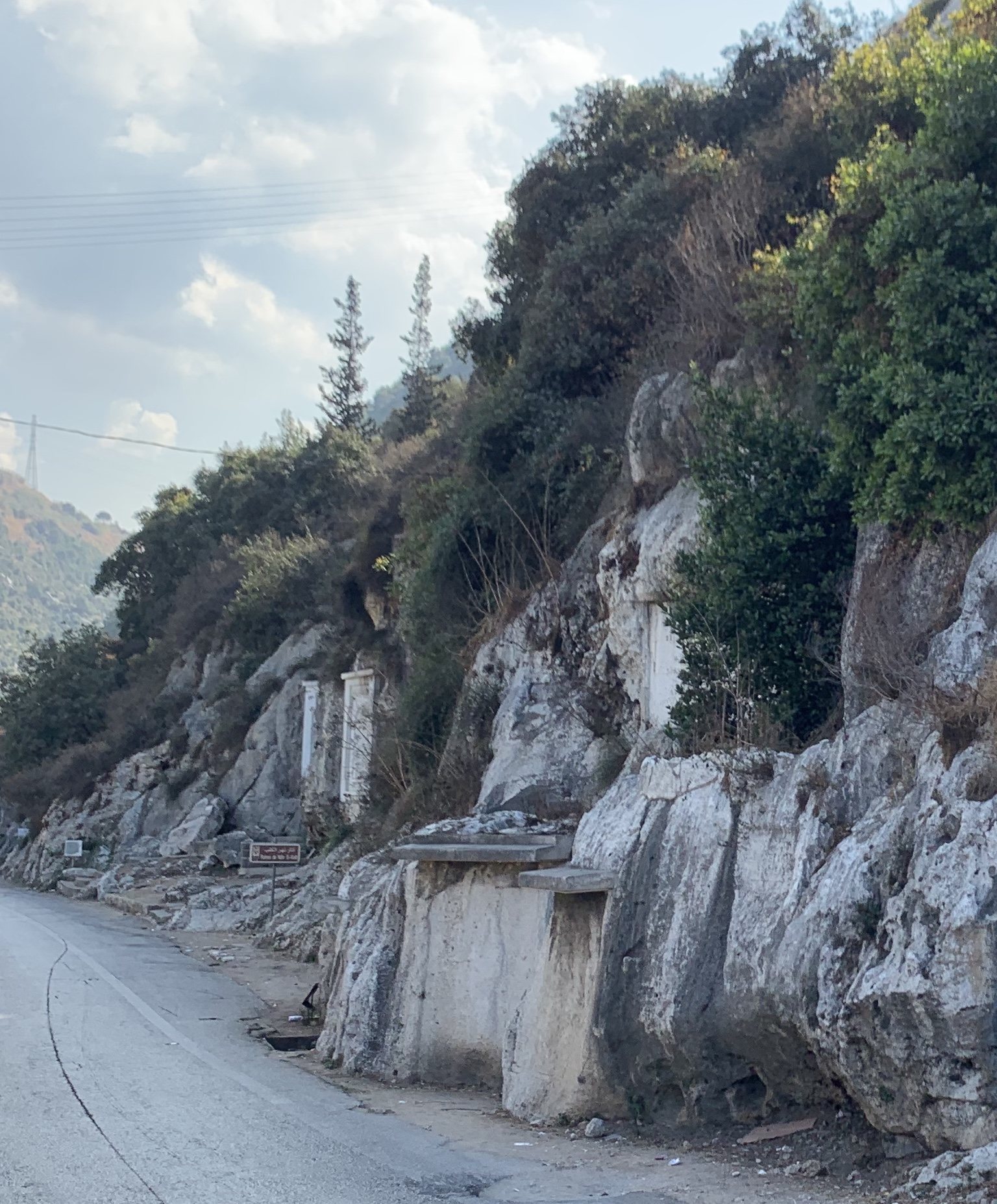
The site occupies two rocky promontories facing one another across the Nahr el-Kalb valley, where the river reaches the Mediterranean. More than 20 inscriptions and reliefs are cut directly into the limestone cliffs above the coastal route. Their languages include Egyptian hieroglyphs, Assyrian and Babylonian cuneiform, Latin, Greek, Arabic, French, and English. The steep terrain and deep gorge constrained movement through the pass, while an ancient road was cut into the rock above the water.
Prehistoric shelters and summit remains
Three rock shelters survive at the site, two of them partly preserved. Rescue excavations prompted by railway construction in 1942 and tunnel construction in 1958 recovered thousands of flint tools, human and animal bones, ochre fragments, worked stones, pottery fragments, earthen floors, and hearths.
The shelters preserve occupation from the Middle Paleolithic, around 100,000 to 70,000 years ago, as well as from the Chalcolithic in the fourth millennium BC and the Bronze Age in the third millennium BC. Neolithic activity extended to the summit of the promontory, where excavators found a stone-working workshop. A possible statue pedestal also remains on the southern promontory. Travelers described a dog- or wolf-shaped statue once placed there, but its identity, history, and final location are uncertain. A headless statue reportedly recovered from the sea in 1942 later disappeared from the National Museum of Beirut.
Egyptian and Mesopotamian reliefs
Ramesses II reliefs
The three Egyptian monuments bear the cartouche of Ramesses II. Their reliefs conventionally show the pharaoh wearing a crown and presenting or striking enemies before a deity. Surviving outlines show Ramesses II beside Egyptian gods, including Horus and Amun-Re. Only two Egyptian hieroglyphic inscriptions remain visibly identifiable in their original form. Napoleon III’s inscription was probably cut over the third, erasing the earlier Egyptian text.
Assyrian reliefs
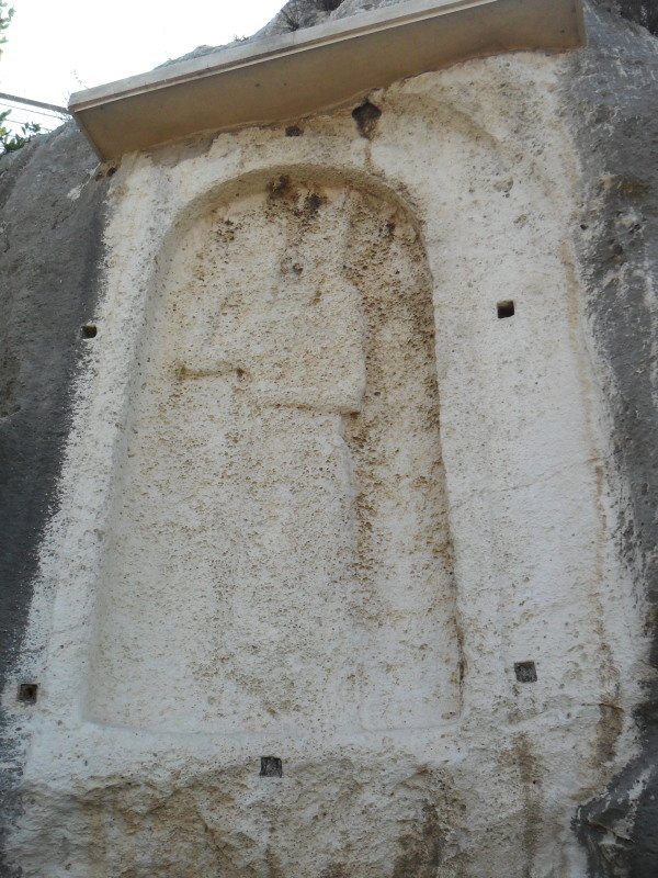
The Assyrian reliefs use an arched frame with a threshold-like lower element. A single large royal figure occupies most of each panel, raising one hand in reverence toward divine symbols. The composition presents the ruler as a visible and dominating presence within the surrounding field of reliefs.
Nebuchadnezzar II monument
The monument attributed to Nebuchadnezzar II originally included a royal image that is now absent. Its inscription survives in five fragments, including one held in the Archaeological Museum of Istanbul.
Roman, Greek, and medieval infrastructure
Road inscriptions and milestone
The inscription associated with Caracalla is set within a tabula ansata, a rectangular panel with projecting handle-like ends. It records road construction by the Legio III Gallica and includes the words “Lyco Flumen.” The partly readable Greek inscription associated with Proclus records road or other engineering work, while the other Greek inscription remains uncertainly identified.
The former Roman milestone was a fragment of a granite column. It marked the distance from Antioch and carried a dedication to Constantine and three Caesars. The column is now lost.
Ottoman and earlier bridges
The Ottoman bridge built in 1901 is a three-arched structure spanning the river. Its two identical construction inscriptions stand at opposite ends. Farther upstream is a rougher three-arched bridge, believed to be Ottoman and repeatedly restored after replacing an earlier medieval bridge. A nearby Arabic inscription records restoration under the Mamluk sultan Barquq between 1384 and 1389, carried out on the order of the emir Aytmish.
The 1942 railway and the modern Beirut-Jounieh motorway altered the transport setting around the cliffs. The inscription commemorating completion of the railway now stands isolated between motorway carriageways.
Modern memorials and military features
Remains of the military structures built on the summit in 1840 survive near the reliefs, and two modern sundials stand nearby. The Lebanese memorial inscriptions associated with independence and the 2000 Israeli withdrawal are made of white marble. Alongside Arabic text, they display the Lebanese cedar and architectural motifs recalling earlier cultures at the site: an Egyptian square frame, an Assyrian arched cartouche and threshold, a Greco-Roman laurel branch, and Arabic muqarnas, three-dimensional tiers of small projecting cells used in Islamic architecture.
The 2019 protest inscription occupies a wall beside the Nahr el-Kalb tunnel. Its design draws on the 1943 memorial and extends the site’s long practice of placing political claims, military events, and public memory directly into the landscape of the crossing.