Vilsegg Castle: A Hohenstaufen Hilltop Fortification in Austria


Site at a Glance
- Rating
- 4.2
- Popularity
- Very Low
- Country
- Austria
- Primary era
- Medieval
- External website
- Open
- Eras represented
- Medieval
- Civilizations
- Holy Roman Empire
- Site type
- Military
- Remains
- Castle
On this page15 sections
History
Vilsegg Castle is a former medieval hilltop fortification near Vils in Austria, built around 1220–1230 in the Hohenstaufen architectural tradition. The Hohenstaufen were a medieval German ruling dynasty whose influence extended across much of the twelfth and thirteenth centuries. The castle became an important stronghold in Tyrol and was associated with service nobles, the Hoheneggs, and the Bishopric of Kempten.
The Hohenegg lordship
In 1263, Henry of Vilsegg was recorded at the castle as a ministerial of the lords of Hohenegg. Ministerials were members of the medieval service nobility who could hold military, administrative, and landed positions for a superior lord. The Hoheneggs held their authority as vassals of the Bishopric of Kempten, an ecclesiastical principality and territorial lord in the Alpine region.
The Vilsegg ministerials were last documented in 1314. After that date, the Hoheneggs themselves occupied the castle. At the beginning of the fourteenth century, Count Meinhard II of Tyrol sought to enlarge his territory at the expense of neighbouring lords and seized several Hohenegg castles, including the nearby cave castle of Loch near Pinswang. Vilsegg nevertheless remained a fief of the Bishopric of Kempten at least until 1408. A fief was a lordship held by a vassal in return for service or allegiance.
Transfer to Austria and decline
After 1408, the Bishopric of Kempten granted Vilsegg Castle and its lordship as a fief to the Duke of Austria. The duke then granted both to the Hoheneggs as a subfief, meaning a fief passed onward by its original holder. When John Francis, the last Hohenegg, died in 1671, the subfief reverted to Austria. The Roman-German emperor consequently became the direct legal vassal of the Bishopric of Kempten in relation to the lordship of Vilsegg.
Austrian governors continued to occupy the castle until at least 1709. By the time Peter Anich’s Atlas Tyrolensis was published in 1774, Vilsegg was already shown as a ruin. The town, castle, and lordship were transferred to the Kingdom of Bavaria in 1806 and returned definitively to Austria in 1816 as a result of the Congress of Vienna.
Damage and conservation
An earthquake in 1939 caused major sections of the walls to collapse, including the east wall of the main tower and its elevated entrance. The Austrian Federal Monuments Department secured the tower in 1953. The Interest Group for the Preservation of the Vilsegg Ruins was founded on 12 July 1981 under the chairmanship of Artur Hartmann. By 1993, the main tower and the northern outer wall had been repaired. The remaining masonry of the residential hall and defences continues to be uncovered and repaired through conservation work.
Remains
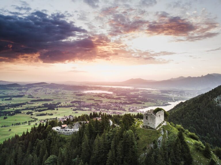
Vilsegg Castle occupies a rocky hill about 887 metres high on the edge of the Salober Mountains, approximately 60 metres above the Vils valley. The slopes fall steeply on every side, giving the fortress a strong defensive position despite its relatively modest height above the valley. The castle stood on a rectangular summit plateau about 75 metres long and up to 15 metres wide, arranged from west to east. Two cross-ditches divided the eastern end into smaller terraces, which were probably also built up or fortified.
Western tower and enclosure
The bergfried
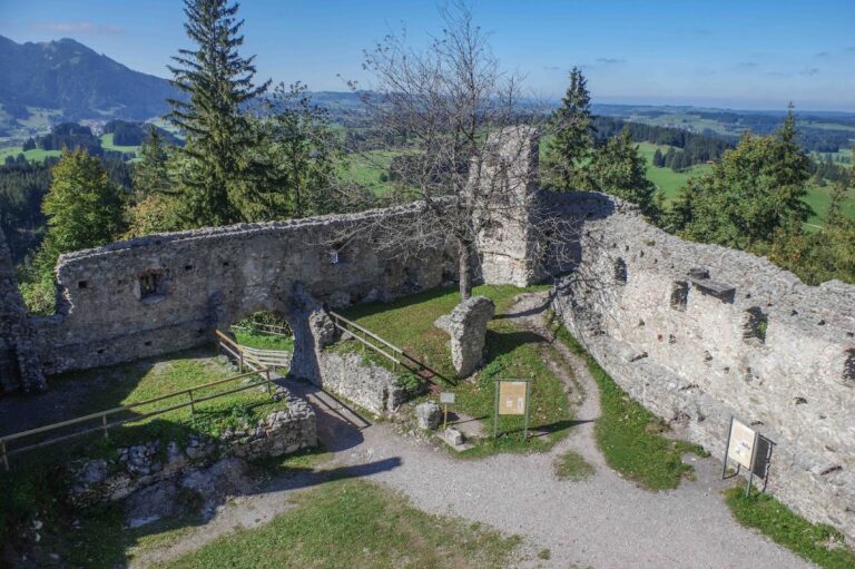
The principal surviving structure is the massive six-storey bergfried, the main fortified tower of a medieval German-speaking castle. It stands at the western end of the plateau and measures approximately 10.7 by 10.1 metres, with a height of about 17 metres. Built around 1220–1230, it has lower walls just under two metres thick. Its masonry is formed from rubble stone with dressed corner blocks, while brick is present in the roof structure.
The tower originally contained four unvaulted storeys and a battlemented defensive platform. It was later heightened and fitted with a gabled roof. Window openings show that it was at least temporarily habitable as well as defensive. The east wall has been missing since the earthquake of 1939, and the surviving structure was secured and partly repaired during modern conservation work.
The enceinte wall
A polygonal enceinte wall extended from the northeast and southeast corners of the bergfried around the western part of the summit plateau. Only a few sections survive. The northern section has undergone conservation and remains connected to the defensive arrangement around the tower.
Courtyard and residential remains
The castle courtyard
A courtyard beside the bergfried measured approximately 17.5 by 15 metres. It formed part of the compact summit complex and was linked to the defensive and residential areas of the castle.
The palas
Beyond the courtyard stood the palas, the castle’s main residential and representational hall. Masonry remains at the eastern end of the courtyard mark the position of this building. Only limited sections of the palas survive, and the remaining masonry is being uncovered and repaired as part of continuing conservation work.
Approach and outer defences
Gates and access route
The northern approach crossed an outer ditch below the bergfried and then turned toward the outer gate. A largely preserved cheek wall, a side wall forming part of a gateway, connects the gate with the northeast corner of the bergfried. After a further steep ascent of approximately 50 metres, the route reached the inner gate at the northeast corner of the main castle.
Ditches and rampart
A zwinger, a narrow fortified space between defensive barriers, followed the inner gate. Two curved ditches with an outer rampart added protection northwest of and below the bergfried. A steep path from below the castle still leads toward the former outer gate, while the wall rising toward the tower is largely preserved.
The well
A rock-cut well was reportedly situated behind the outer gate. It is described as extending down toward the valley floor and the stream beside the castle path, forming part of the practical infrastructure of the outer approach.
Nearby sites