Stonehenge: A Prehistoric Monument and Ceremonial Landscape
Site at a Glance
- Rating
- 4.5
- Popularity
- Very High
- Country
- United Kingdom
- Primary era
- Stone Age
- External website
- Open
- Eras represented
- Stone Age, Bronze Age
- Civilizations
- Unclassified
- Site type
- Religious
- Remains
- Sanctuary
On this page22 sections
History
Stonehenge is a prehistoric monument in the United Kingdom, near Amesbury on Salisbury Plain in Wiltshire, England. Communities of the Neolithic, or New Stone Age, and the Bronze Age built it in several phases between about 3100 and 1600 BC. The monument combined earthworks, timber structures, and carefully arranged stones, and it formed part of a much larger ceremonial landscape containing burial mounds, enclosures, avenues, and other monuments.
Before the stone monument
The wider Salisbury Plain already had ritual importance before Stonehenge was constructed. Four, and possibly five, large postholes dating to about 8000 BC indicate Mesolithic activity in the area. The Mesolithic was the period of hunter-gatherer communities before farming became established. Later monuments included the Stonehenge Cursus, a long enclosure built about 3500 BC roughly 700 metres north of the monument, together with numerous burial mounds and enclosures.
The first Stonehenge phase began around 3100 BC with a circular bank and ditch. Human remains were deposited at the site from approximately this period, suggesting that it may have served as a burial ground from its beginnings. Cremation burials continued for at least another 500 years. In the second phase, from approximately 2900 to 2600 BC, timber structures and alignments were installed inside the enclosure. At least 25 pits later known as the Aubrey Holes contained cremation burials, while about 30 further cremations were placed in the ditch and elsewhere within the monument.
The megalithic phases
Around 2600 BC, construction shifted from timber to stone. Smaller bluestones were brought from western Wales, while the large sarsens, a hard silicified sandstone found in southern England, were erected during the principal megalithic phase between approximately 2600 and 2400 BC. The great stone settings transformed the earlier enclosure into the monument recognizable today. Later Bronze Age activity included rearrangements of the bluestones and the construction of the Y and Z Holes around 1600 BC, although the purpose of these pits remains unknown.
The stones reveal long-distance connections between communities. Many people buried at Stonehenge around the time of its construction probably came from western Wales or from the region that supplied the bluestones. Around 2500 BC, Bell Beaker communities arrived in Britain from mainland Europe and lived alongside earlier populations for several centuries during the construction of the megalithic monument. The movement of people, stone, and technical knowledge placed Stonehenge within a broad network extending across Britain and beyond.
A ritual landscape
Stonehenge was linked to Durrington Walls, its avenues, and the River Avon. One interpretation presents Durrington Walls as a place associated with the living and Stonehenge as a domain of the dead, with movement along the Avon forming a ritual passage between them. Proposed functions for Stonehenge include a funerary monument, an ancestor-worship site, a healing centre, an astronomical observatory, a seasonal gathering place, and a monument expressing Neolithic political or cultural unity. None of these explanations is definitive, and the monument may have served several purposes over time.
The monument also continued to attract activity in later periods. Roman coins, pottery, food-animal bones, and other remains indicate substantial ritual or ceremonial activity during the Roman period, although the extent and continuity of that use are unknown. Iron Age activity in the surrounding area included the nearby hillfort called Vespasian’s Camp, which was not a Roman installation. A decapitated male skeleton found within the stone circles and dated to approximately AD 600 to 690 may represent a judicial execution or sacrifice, but its interpretation remains uncertain. Roman and medieval objects at or near Stonehenge do not establish continuous use.
Legend and antiquarian interpretation
Medieval tradition connected Stonehenge with the legends of Merlin, King Aurelius Ambrosius, and Uther Pendragon in the writings of Geoffrey of Monmouth, a twelfth-century cleric and chronicler. In these fictional stories, magical healing stones were transferred from Ireland. The legendary movement of stones has sometimes been compared with the possible prehistoric movement of bluestones from Wales, but no historical connection between the medieval tale and the construction of Stonehenge has been established.
Early modern antiquarians proposed Roman, Danish, and later Druidic origins for the monument. John Aubrey and William Stukeley helped establish its association with Druids, religious specialists linked to Iron Age Celtic societies. Modern archaeology places Stonehenge roughly 2,000 years before the historical Druids and has found no demonstrated connection between them and the monument.
Excavation and modern protection
George, Duke of Buckingham, carried out an early excavation at Stonehenge in 1620 on the instructions of King James I. John Aubrey examined the monument in 1666 and identified the pits later named the Aubrey Holes. William Stukeley studied Stonehenge and its surrounding features in the early eighteenth century, and John Wood the Elder produced the most accurate early plan in 1740. William Cunnington and Richard Colt Hoare undertook extensive excavations at Stonehenge and in nearby burial mounds during the early nineteenth century.
Major twentieth-century investigations included William Gowland’s excavation and stabilization work in 1901, William Hawley’s excavations from 1919 to 1926, and the re-excavation of much of the monument by Richard Atkinson, Stuart Piggott, and J. F. S. Stone during the 1940s and 1950s. Atkinson’s work helped establish the principal construction phases. Research and landscape projects from the 1960s onward identified Mesolithic postholes, additional ditches, the Stonehenge Archer, features near the Avenue, and numerous previously unknown monuments in the surrounding landscape.
Re-examination of human remains from the Aubrey Holes in 2008 and 2013 identified more than 50,000 cremated bone fragments representing 63 individuals, including men, women, and children. The remains had been excavated in the 1920s and reburied together in Aubrey Hole 7 in 1935. Research led by Mike Parker Pearson during the 2000s examined the relationships between Stonehenge, Durrington Walls, the Avenue, and the River Avon. Work between 2017 and 2021 proposed that some bluestones came from a dismantled stone circle at Waun Mawn in the Preseli Hills of Wales. The proposed earlier circle was about 110 metres in diameter, and the interpretation remains debated.
Stonehenge changed ownership several times after the sixteenth century. The Antrobus family acquired the estate in 1824, and Cecil Chubb bought the monument at auction in 1915 for £6,600 before giving it to the nation in 1918. Stonehenge is owned by the Crown Estate and managed by English Heritage, while the surrounding land is owned by the National Trust. It has been protected as a scheduled monument since 1882. Stonehenge, Avebury and Associated Sites were added to the UNESCO World Heritage List in 1986, recognizing their exceptional cultural value and evidence of prehistoric traditions in architecture, technology, monumental art, planning, and landscape design.
Twentieth-century conservation repeatedly stabilized and re-erected fallen stones, in several cases using concrete foundations. The principal campaigns took place in 1901, 1920, 1958, and 1963, altering the modern appearance of the monument while preserving its stability. Modern religious use has involved Neo-Druids, Pagans, and other Earth-based religious groups, despite the lack of a demonstrated ancient Druidic connection. The Stonehenge Free Festival ran from 1972 to 1984. After the 1985 Battle of the Beanfield, religious access was restricted for nearly fifteen years, with limited solstice access resuming between 1998 and 2000 following legal challenges.
Traffic and nearby roads damaged the monument’s setting for many years. The A344 was closed and replaced with grass in 2013, when a visitor centre designed by Denton Corker Marshall also opened. A proposed road tunnel beneath the landscape was repeatedly contested. Although the scheme was approved in 2023 and challenged in court, its Development Consent Order was revoked in March 2026.
Remains
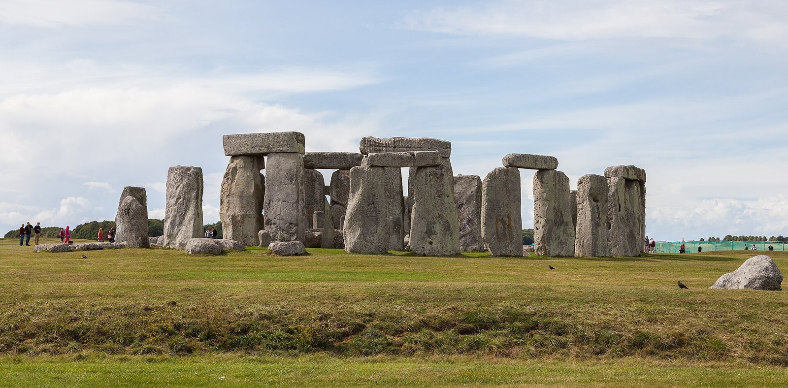
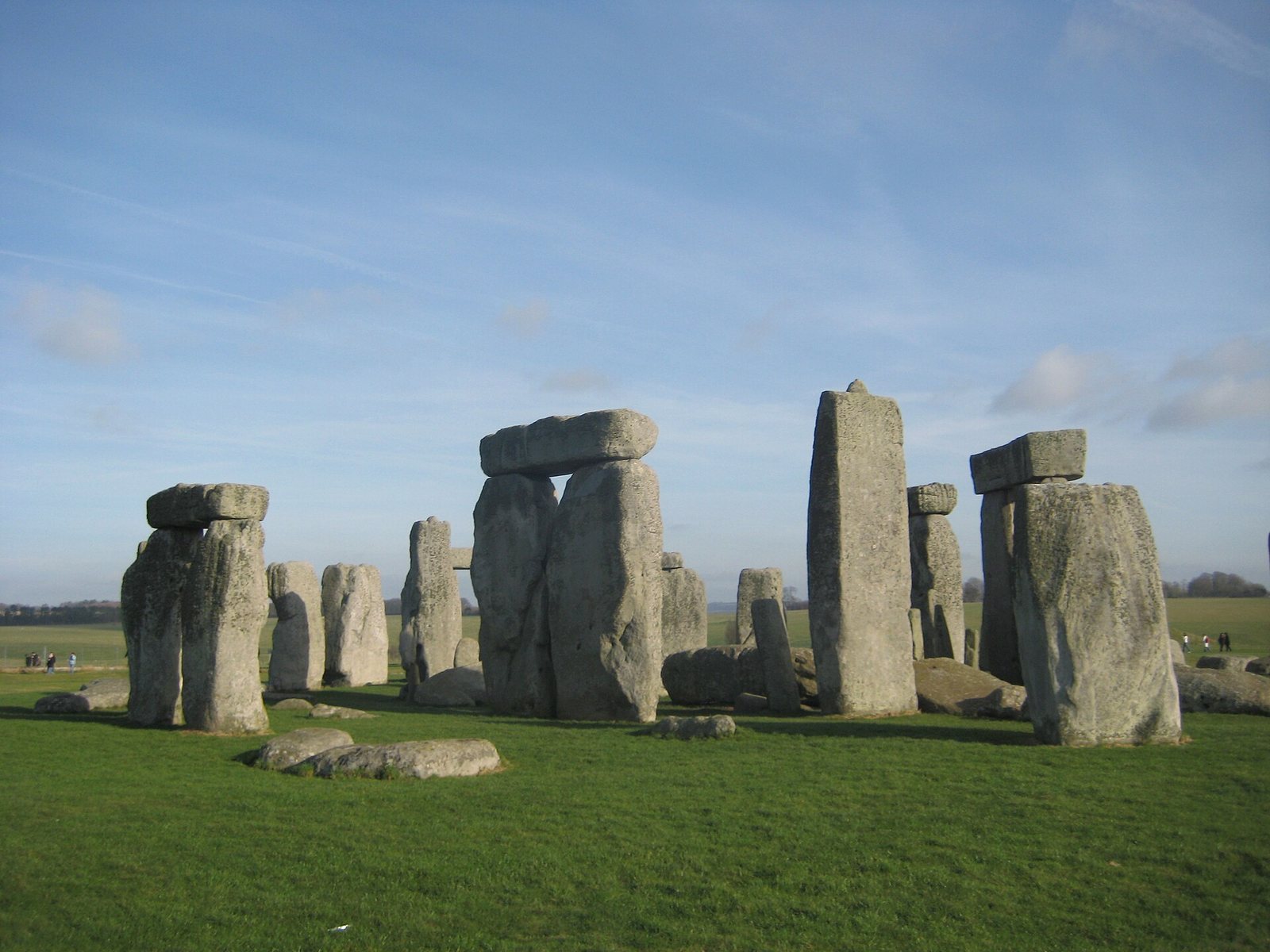
Stonehenge is organized around a circular earthwork, a ring of large sarsen stones, an inner arrangement of bluestones, and five central sarsen trilithons. A trilithon consists of two upright stones supporting a horizontal lintel. The surviving monument is broadly aligned with the summer-solstice sunrise and winter-solstice sunset, although the exact astronomical meaning of this arrangement remains disputed.
The earthwork enclosure
Bank, ditch, and entrances
The earliest enclosure is about 110 metres in diameter. Its ditch was dug in sections through Seaford chalk, and the excavated chalk was piled up to form the bank. A large entrance lies to the northeast and a smaller opening to the south. Deer and cattle bones, together with worked flint tools, were deposited in the base of the ditch. The bank was later deliberately reduced, while the ditch continued to fill naturally.
Aubrey Holes
Fifty-six pits called the Aubrey Holes lie near the inner edge of the enclosing ditch. Each is about one metre across. They may originally have held timber posts or bluestones, and many were later used for cremation burials. Their original purpose is uncertain. The cremated remains recovered from them include men, women, and children, and the large quantity of bone later reburied in Aubrey Hole 7 reflects the monument’s long funerary use.
Y and Z Holes
The Y and Z Holes form two roughly concentric rings around the sarsen arrangement. The outer Y ring contains 30 pits and measures approximately 54 metres across, while the inner Z ring contains 29 pits and measures about 39 metres. Their purpose is unknown. They belong to the later Bronze Age phase around 1600 BC and form part of the monument’s final major rearrangements.
Timber and processional features
Early timber settings
The timber phase included smaller postholes within the enclosure, additional posts at the northeastern entrance, and a parallel alignment extending inward from the southern entrance. These features belong to the period when Stonehenge was developing from an earthwork enclosure into a more complex ceremonial site. The later reduction of the bank and natural filling of the ditch changed the appearance of the original enclosure.
The Cursus and Avenue
The Stonehenge Cursus lies about 700 metres north of the monument and consists of two parallel banks and ditches. Stonehenge Avenue forms an aligned route extending approximately three kilometres between Stonehenge and the River Avon. Excavation where the Avenue meets the river revealed a circular area that may have contained four stones marking the beginning of the route. Two enormous pits within the Cursus are aligned toward the midsummer sunrise and sunset when viewed from the Heel Stone, although their purpose is unknown.
The sarsen monument
Outer sarsen circle
The outer sarsen circle was designed with 30 worked upright stones and 30 horizontal lintels, creating a continuous ring about 30 metres in diameter. Each upright is approximately 4.0 to 4.1 metres high, 2.1 metres wide, and about 25 to 26 tons in weight. The lintels measure about 3.2 metres long, one metre wide, and 0.8 metres thick, with their upper surfaces roughly 4.9 metres above the ground. Chemical analysis shows that 50 of the 52 examined sarsens match stone from West Woods near Marlborough in Wiltshire, about 25 to 26 kilometres north of Stonehenge.
The uprights widen slightly toward their tops, preserving an appearance of verticality when viewed from below, while the lintels curve gently to sustain the visual effect of a circle. The inner faces were worked more finely than the outer surfaces. Mortise-and-tenon joints secured the lintels to the uprights, and tongue-and-groove joints linked adjacent lintels. These construction methods are associated with woodworking and were applied here to massive stone elements.
Central trilithons
Five central trilithons formed a horseshoe about 13.7 metres across, opening toward the northeast. Their ten uprights and five lintels were arranged symmetrically, and each complete structure weighed up to approximately 50 tons. The smallest pair stood about six metres high, the next pair was slightly taller, and the largest southwestern trilithon reached approximately 7.3 to 7.5 metres. Only one upright of the Great Trilithon remains standing, with about 6.7 metres visible above ground and a further 2.4 metres below ground.
Carvings and central stones
Stone 53 carries a dagger and 14 axehead images, while additional axehead carvings appear on Stones 3, 4, and 5. Laser scanning indicates that the forms resemble late Bronze Age weapons, although the exact date of the carvings is uncertain. Near the centre of the trilithon horseshoe lies the Altar Stone, also called Stone 80, a purple-and-green sandstone slab whose origin was once associated with Wales. Its chemical composition has instead been matched to rocks in the Orcadian Basin of northeastern Scotland, implying a possible transport distance of about 690 to 700 kilometres. The slab is partly buried beneath a collapsed sarsen.
Bluestones and outer markers
Bluestone settings
The bluestones were placed between the outer sarsen circle and the central trilithons, with another bluestone horseshoe inside the sarsen horseshoe. Stonehenge may originally have contained as many as 80 bluestones, while traces of about 43 can be identified and roughly 29 are visible today. The group includes dolerite, tuff, rhyolite, and sandstone. Many came from the Preseli Hills of southwestern Wales, about 230 to 240 kilometres away, and evidence from Welsh quarries indicates that at least some were extracted by people rather than transported by glaciers.
Some bluestones have unusual acoustic properties and produce a loud ringing or clanging sound when struck. Comparable ringing stones occur in the Preseli region, where such stones were reportedly used as church bells until the eighteenth century. The sound-producing qualities may help explain why particular stones were selected, although no single purpose can be assigned to them.
Entrance and station stones
The Heel Stone is a rough Tertiary sandstone monolith outside the northeastern entrance, beside the end of Stonehenge Avenue. About 4.9 metres is visible above ground, and the stone leans inward. It may once have been accompanied by a second stone. Two or possibly three portal stones stood just inside the northeastern entrance, of which the fallen Slaughter Stone, approximately 4.9 metres long, is the surviving remnant. Four Station Stones occupied the corners of a rectangle around the monument. Two remain, while the other two stood on low mounds that are not burial barrows.
Survival and archaeological evidence
About 93 numbered stones or stone fragments are visible today. Only a minority of the surviving uprights and lintels remain in their original positions, since many were re-erected or stabilized during twentieth-century restoration. Two lintels remain in their original positions. Stone 22 fell during a severe storm on 31 December 1900. Sarsen Stone 56 was straightened and set in concrete in 1901, approximately 0.5 metres from its original position. Three fallen sarsens were re-erected in 1958, and Stone 23 was re-erected after falling before the final major restoration in 1963.
Archaeological remains associated with Stonehenge include cremated and unburnt human bone, animal bones, worked flint, late Neolithic pottery, urns, charred wood, Roman pottery, coins, and food-animal remains. Investigations near the proposed road-tunnel area also revealed Bronze Age graves, late Neolithic pottery, a C-shaped enclosure, burnt flint, a shale object, and a child burial. The surrounding landscape contains hundreds of Neolithic and Bronze Age burial mounds and related monuments, as well as Mesolithic postholes, possible timber and stone structures, additional pits, and as many as 17 nearby monuments that may date to the Late Neolithic.
A shallow mound about 40 centimetres high lies between Stones 54 and 10. It is separated from the natural slope and appears in eighteenth- and nineteenth-century illustrations, but its date and purpose remain uncertain. Other shallow banks between the Y and Z Holes may represent spoil deposits or deliberately planted screening banks. The methods used to transport and raise the stones also remain uncertain. Proposed techniques include timber tracks, sledges lubricated with animal fat, and simple lifting devices such as shear legs. In 1995, more than 100 workers experimentally moved a 40-ton slab 29 kilometres near Stonehenge using a sledge.