Knap of Howar: A Neolithic Farmstead on Papa Westray
Site at a Glance
- Rating
- 4.9
- Popularity
- Very Low
- Country
- United Kingdom
- Primary era
- Stone Age
- External website
- Open
- Eras represented
- Stone Age
- Civilizations
- Unclassified
- Site type
- Domestic
- Remains
- House
On this page11 sections
History
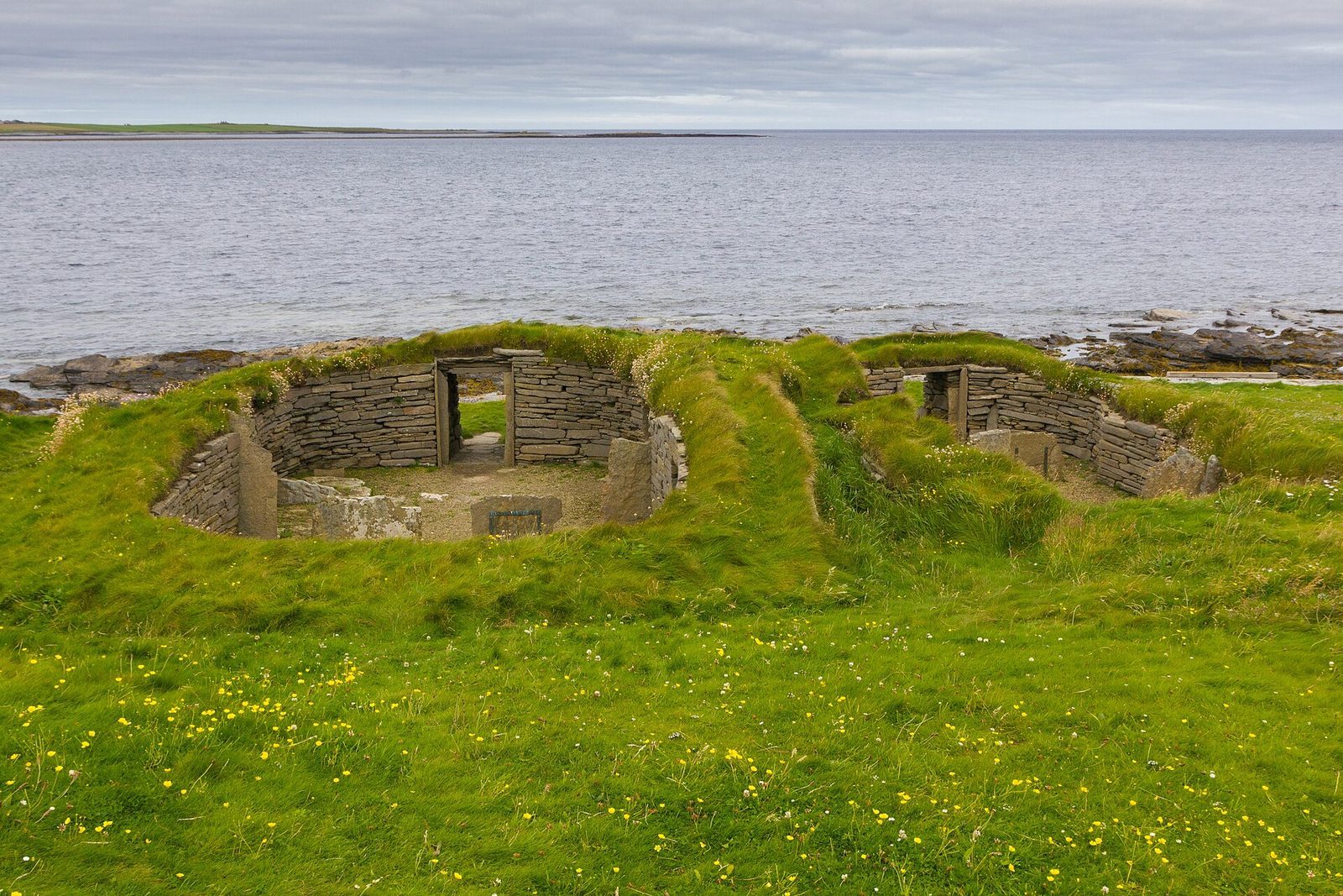
Knap of Howar is a Neolithic farmstead on Papa Westray in the United Kingdom, built by an early farming community and occupied broadly between about 3800 and 2800 BC. Several dates place its principal occupation between about 3700 and 3100 BC. It may be the oldest preserved stone house in northern Europe and predates the comparable Neolithic houses at Skara Brae.
Neolithic occupation
The two buildings formed a farmstead, although their construction over an earlier midden suggests that an earlier farm may have occupied the same location. A midden is an accumulated refuse deposit containing materials such as shells, animal bones, ash, and domestic waste. At Knap of Howar, the lower midden layer and a stone pavement south of House 1 represent the first of two phases of use, and both contain Unstan Ware pottery. This finely made, often decorated Neolithic pottery tradition also provides evidence of links with other settlements and burial monuments.
The inhabitants raised cattle, sheep, and pigs, and cultivated naked barley and wheat. Naked barley is a form whose grain separates more readily from its husk after threshing. People at the farmstead gathered shellfish and hazelnuts, fished from boats, and hunted birds, seals, and possibly deer. Whether deer were hunted on Orkney or on the Scottish mainland remains uncertain. Animal remains include unusually large cattle and sheep belonging to a primitive breed that may not yet have had a woolly fleece.
The settlement was associated with nearby chambered cairns, including the broadly contemporary burial monument on Holm of Papa Westray. A chambered cairn is a prehistoric stone-built tomb containing one or more internal chambers. Connections also extended farther afield to places such as Balbridie and Eilean Dòmhnuill. The arrangement at Knap of Howar is unusual for Orkney and Shetland, although rectangular stone or timber buildings of related broad form are known elsewhere in Scotland.
Discovery and archaeological interpretation
William Traill, the landowner, and William Kirkness discovered Knap of Howar in 1929 and excavated it in 1930. The high quality of the masonry led archaeologists at first to identify the buildings as Iron Age. The Iron Age was the later prehistoric period that followed the Neolithic and is associated with the widespread use of iron tools and weapons. Radiocarbon dating carried out in the 1970s established that Knap of Howar was Neolithic. The 1930 excavation was captured in a silent film now held in the BBC archives.
The site was placed in state care in 1937, and a seawall was built to protect it from marine erosion. Anna Ritchie directed further excavations from 1973 to 1975 before restoration work. Historic Environment Scotland now manages the farmstead. These investigations clarified the sequence of occupation, the construction of the two buildings, and the farming, fishing, and craft activities carried out there.
Remains
Layout and construction
Knap of Howar consists of two adjacent, thick-walled stone buildings with rounded-rectangular or ovoid plans. They touch at one point and are linked by a low passage. The larger and older building is House 1, while House 2 has been interpreted as a workshop, storehouse, or possibly a second house. Both structures were erected on a midden about 0.4 metres thick, composed of dark-grey clay containing mainly shell remains.
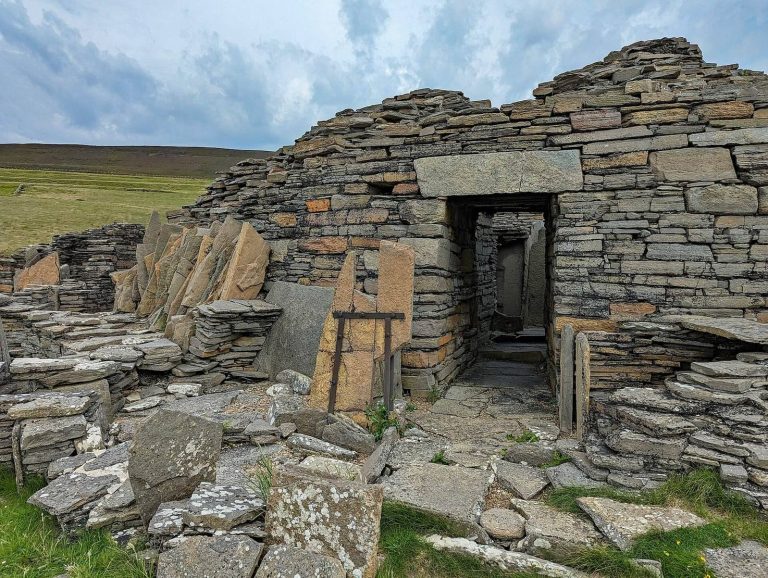
The inner wall of House 1 rests on natural glacial clay, while its outer wall rests on midden material, creating a level difference of about 35 centimetres. Midden material also surrounds the buildings and helped protect them. Their walls are double-faced dry-stone constructions made from thin local sandstone slabs of the Rousay Flags group. Dry-stone masonry uses stones stacked without mortar. The spaces between the inner and outer wall faces were filled with midden material, while the coastal stone naturally split into slabs suitable for building.
House 1
Rooms and entrance
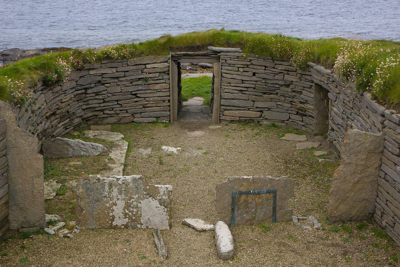
House 1 has an internal area of about 10 by 5 metres, with walls preserved to an eaves height of approximately 1.6 metres. Its two rooms measure about 5 by 5.3 metres and 4.5 by 4.6 metres, and the walls are roughly 1.5 to 1.7 metres thick. Entry was from the west through a passage about 0.75 metres long paved with stone slabs. The stone door jambs and lintel remain intact, and the doorway is about 1.3 metres high. A possible external porch has also been suggested.
Upright flat stones and wooden posts divided the interior. The holes for the posts remain visible. The western room contains a low stone bench along its southern wall. The eastern room was probably a kitchen, with a hearth set into a floor pit and probably a wooden bench along the wall.
Domestic installations
Two querns were found in the eastern room. A quern is a stone tool for grinding grain or other materials. Here, the querns were also used to crush shells, which were mixed with clay during the manufacture of pottery. Hearths, stone beds or boxes, partition screens, and wall shelves or cupboards survive in well-preserved condition.
Both buildings have very low entrances facing the sea. Light and ventilation probably passed through an opening in the roof above the hearths. The roofs were probably made partly from wood or whale ribs and covered with thatch or turf. Holes and recesses in the walls indicate the positions of roof-support timbers.
House 2
Workshop and storage rooms
House 2 is a three-room building interpreted mainly as a workshop and storehouse. Its interior measures approximately 9.1 by 3.7 metres and has a roughly trapezoidal plan, narrowing from about 3.6 metres to 2.6 metres. It also had a western entrance. Upright flat stones divided the building into three rooms.
The western room may have served as a shed or store. The central room was probably the main workshop and contained a central stone hearth. The eastern room probably provided storage, with wall cupboards and three floor pits. The central room contained an occupation layer up to 20 centimetres thick, formed by two deposits associated with two different hearths. An earth layer 2 to 4 centimetres thick covered the floor of the eastern room and contained ash particles.
Food, craft, and landscape evidence
Finds and installations from the buildings show that domestic and craft work took place at the farmstead. The inhabitants made finely decorated Unstan Ware pottery and tools from stone and bone. Midden material includes shellfish, especially limpets. Fish remains include herring, conger eel, turbot, saithe, ling, cod, ballan wrasse, and eel. Some species were probably caught from boats with lines, while fish living close to shore may have been taken with hooks or nets.
Bird remains include geese, swans, cormorants, gulls, puffins, starlings, and skuas. During the Neolithic, the low-lying settlement apparently stood inland on a grass-covered plain protected by dunes, rather than directly beside the modern coastline. Westray and Papa Westray may then have been connected.
The distribution of Unstan Ware connects Knap of Howar with Balbridie, where a timber hall measuring about 26 by 13 metres was excavated. Comparable two-house arrangements enclosed by a palisade are known from Loch Olabhat on North Uist, including the artificial-island site of Eilean Dòmhnuill. A palisade is an enclosing fence made from upright posts. Later settlements such as Skara Brae and Barnhouse used Grooved Ware, a later Neolithic pottery tradition distinguished by grooved decoration, rather than Unstan Ware.