Shornemead Fort: A Thames Coastal Defence Fort in England


Site at a Glance
- Rating
- 4.7
- Popularity
- Very Low
- Country
- United Kingdom
- Primary era
- Modern
- Eras represented
- Modern
- Civilizations
- British
- Site type
- Military
- Remains
- Fort
On this page16 sections
History
Shornemead Fort is a disused artillery fort in the United Kingdom, built by Britain between 1861 and 1870 to defend the entrance to the Thames against seaborne attack. It occupied the south bank at a sharp bend in the river, where ships were forced to slow and artillery could cover the waterway in both directions. The fort was created during military tension and an arms race between Britain and France, and formed part of a planned system protecting the Thames and its naval and industrial installations.
Earlier Fortifications at Shornemead
Shornemead had already been fortified twice. A small pentagonal artillery battery was built there in 1795 and 1796 during the Napoleonic Wars, the conflict between Britain and Napoleonic France. Its four 24-pounder guns stood in open positions with a range of about 2.3 kilometres. The battery was abandoned after Napoleon’s defeat.
A second fort was constructed between 1848 and 1852, although marsh-related subsidence delayed completion until 1853. Subsidence, the sinking or movement of unstable ground, badly cracked its cookhouse and barracks, and one caponier, a covered structure projecting into the ditch for defensive fire, separated from the rest of the fort. The structure had a polygonal plan influenced by the French military engineer Montalembert, whose designs favoured numerous protected gun positions. It carried thirteen 32-pounder guns in an open battery, with river-facing ramparts on three sides and landward defences around the barracks, magazines, and ditch.
The Royal Commission Plan
By the late 1850s, Britain’s coastal defences were considered largely obsolete because of more powerful rifled guns and steam-powered ironclad warships. Rifled guns used internal grooves to improve accuracy, while ironclads were steam-powered warships protected by iron armour. The Thames required particular protection because it led to naval and industrial installations at Deptford, Woolwich Arsenal, North Woolwich, and Purfleet.
In 1860, the Royal Commission on the Defence of the United Kingdom, a government-appointed body that assessed Britain’s defensive needs, recommended a triangle of forts on the lower Thames east of Gravesend. The plan called for new or replacement works at Shornemead, Coalhouse Point, and Cliffe, whose guns would create interlocking fields of fire. A further defensive line toward Chatham was proposed but never built.
The third and final Shornemead Fort was designed by Captain Siborne of the Royal Engineers, the British Army corps responsible for military construction and related technical work. He also designed the associated forts at Coalhouse Point and Cliffe, apart from their ironwork. Captain English and Lieutenant English designed the iron and steel casemate shields. A casemate was a strongly protected chamber or enclosure for artillery or troops.
Construction and Armament
The new fort was estimated to cost £211,063 and was built on the same unstable marshland that had damaged its predecessor. Subsidence forced substantial changes to the design in 1867, and construction was completed in 1870. The fort had a D-shaped plan, with protected gun chambers replacing the vulnerable open positions used by earlier works. Its shields were more than 635 millimetres thick, made from layers of steel and wood faced with granite.
The original armament comprised eleven 11-inch rifled muzzle-loading guns in the casemates and three 9-inch rifled muzzle-loading guns in an open battery facing west. Rifled muzzle-loading guns were large artillery pieces loaded through the barrel, with rifling to improve their accuracy. The guns were mounted on special carriages that absorbed recoil and ran on rails so they could be aimed across a horizontal arc.
The original design envisaged fourteen roof-mounted guns behind shields and a masonry parapet, as well as two pivot guns and twenty other guns at ground level. Subsidence problems led to the abandonment of the roof armament. Eleven casemates instead formed an arc pointing downriver toward Lower Hope Point, while the western open battery held three guns directed upriver toward Gravesend and Tilbury.
Later Military Use
Searchlights were installed in separate positions west of the fort, and a submarine mining establishment was built nearby. Submarine mining was a coastal-defence system in which controlled mines were placed in a waterway and operated from shore. Shornemead later served as a training facility for the Thames Militia Division (Submarine Miners), Royal Engineers.
Between 1895 and 1907, the fort was disarmed because subsidence had made it unsafe to fire the guns and because changing military conditions had made it strategically redundant. Two 6-pounder quick-firing guns were added in 1895 to protect a proposed wartime minefield, then the fort was temporarily rearmed in 1913 with two 12-pounder quick-firing guns outside the main structure.
In 1941, Shornemead became an emergency battery, a temporary wartime artillery position intended to strengthen coastal defence. Two 5.5-inch naval guns were placed in the same external positions used in 1913 and protected by concrete gun houses. The site was surrounded by barbed wire, concrete pillboxes, and searchlights during the Second World War. An embarkation hard, a surfaced riverside landing place for loading troops and equipment onto landing craft, was built beside the river for the D-Day operation.
The fort was reduced to care-and-maintenance status in November 1943, meaning that it was retained with minimal staffing and upkeep rather than operated as an active battery. The external battery was deactivated in 1945 and demolished around 1976. The barracks were also used for many years by soldiers training at the nearby Milton rifle range, with accommodation that included lecture rooms, staff quarters, and a swimming pool east of the fort.
Demolition and Conservation
After the Second World War, the fort was abandoned. Much of the structure was demolished in the 1960s by the Army Demolition School of the Royal Engineers as a training exercise. Staff accommodation and the surviving parts of the mining establishment were demolished in the 1970s. The remaining fort fragments and surrounding land now form part of the Royal Society for the Protection of Birds’ Shorne Marshes Nature Reserve, a protected wetland managed by the British wildlife-conservation charity. The magazines were sealed in 2008 after flooding made them inaccessible.
Remains
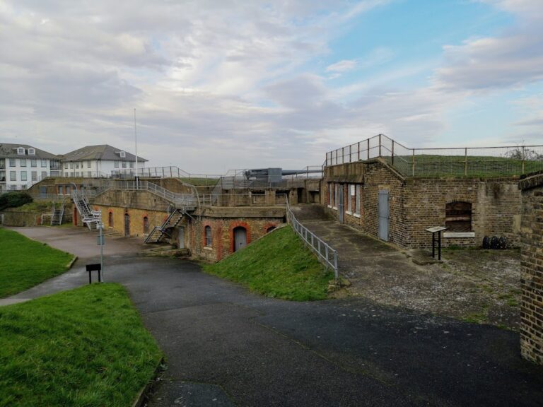
Shornemead Fort occupied marshy ground on the south bank of the Thames at a sharply curving section of the river. The final fort had a D-shaped layout, with an arc of protected casemates along one side, a west-facing open battery, a rear barracks, perimeter defences, and an open parade ground at the centre. Subsidence affected both the second and third fortifications, shaping the final design and contributing to the later condition of the site.
Main Fort Structures
Casemates and Gun Positions
The surviving front of the casemates forms the principal above-ground fragment. These chambers were protected by shields more than 635 millimetres thick, built from layers of steel and wood with granite facing. Eleven casemates were arranged in an arc and directed downriver toward Lower Hope Point. Their original 11-inch rifled muzzle-loading guns had an approximate range of 5.5 kilometres and stood on special garrison carriages that absorbed recoil and moved along traverse rails.
Western Open Battery
At the western end of the fort, an open battery held three 9-inch rifled muzzle-loading guns aimed upriver toward Gravesend and Tilbury. An open battery was an artillery position not enclosed within a roofed or fully protected casemate. The battery formed part of the fort’s original armament and allowed it to support the older fortifications farther upriver.
Defensible Barracks and Perimeter
A single-storey defensible barracks of Kentish Ragstone stood at the rear of the fort. Kentish Ragstone is a locally associated building stone from Kent. Loopholes in the barracks enabled the garrison to fire toward the landward side. Three caponiers protected the perimeter, while a ditch originally ran in front of the casemates and open battery. The ditch was filled during the 1880s, and the barracks and administrative buildings have since disappeared.
Underground Magazines
Magazines beneath the casemates and open battery were arranged as a line of shell and cartridge storerooms. A lighting passage ran along their rear, while an ammunition passage extended along the front. The underground magazines survive, but flooding led to their being sealed in 2008 and they are inaccessible.
External Defences and River Works
Later Gun Emplacements
The two 6-pounder quick-firing guns added in 1895 were associated with the river minefield defences. The two 12-pounder guns installed in 1913 and the two 5.5-inch naval guns installed in 1941 occupied external positions about 250 metres east of the fort. The later positions were protected by concrete gun houses. The battery was demolished around 1976.
Searchlights and Mining Establishment
Separate searchlight positions and a submarine mining establishment stood west of the fort. During the Second World War, the wider defensive area also contained concrete pillboxes and barbed-wire obstacles. The remaining parts of the mining establishment were demolished in the 1970s.
Embarkation Hard
The riverside embarkation hard built for the D-Day operation lay below the fort. It was a hard-surfaced landing place used to load troops, vehicles, or equipment onto landing craft. Its construction formed part of the site’s wartime adaptation alongside the external naval guns and concrete defences.
Nearby sites