Santi Quaranta: A Roman Complex in Benevento
Site at a Glance
- Popularity
- Medium
- Country
- Italy
- Primary era
- Classical
- Eras represented
- Classical, Medieval
- Civilizations
- Lombard, Roman
- Site type
- Civic
- Remains
- Cryptoporticus
On this page15 sections
History
Santi Quaranta is a Roman complex in Benevento, Italy, whose construction date and original purpose remain uncertain. It was built in three or four phases. Proposed dates range from the late first century BC to the third century AD: some scholars place its earliest core in the late first century BC, others favor the first century AD, while another proposal dates the complex to the late second or third century AD. An expansion under the emperors Trajan and Hadrian has also been proposed.
Roman complex and setting
The complex formed part of the Roman city, though it stood beyond the later walls of the late-antique and Lombard periods. Benevento’s Roman layout remains debated. The natural slope may have marked the edge of the colony founded in 268 BC at a settlement associated with the Samnites, an ancient people of south-central Italy, and the related Irpini. Santi Quaranta may have replaced the colony’s earliest walls.
The site faced the Leproso Bridge, where travelers arriving from Rome entered Benevento on the Via Appia, a major Roman road linking Rome with southern Italy. The sloping lane now called Via Ursus leads to the complex and may have served as another route for the Via Appia. A further road has been proposed above the complex, running parallel to its main corridor. In that reconstruction, it crossed the Calore River at the Pons Maior, passed a pottery-working district, and continued east toward the city’s citadel. Its identity is disputed: it may have been a branch of the Via Latina or a road through Upper Samnium.
Competing interpretations of its purpose
In 1878, Saverio Sorda proposed that the building was a cryptoporticus, a covered, vaulted passage that could serve as a public walkway. This explanation gained wide acceptance. Almerico Meomartini instead interpreted it as a commercial storehouse for imported goods, especially food. He pointed to the narrow main corridor, its limited ventilation, and the possibility of further storage corridors; contemporaries treated the proposal skeptically. An earlier suggestion that the building was part of a grand bath complex was later rejected.
Other interpretations connect Santi Quaranta with public buildings nearby. In 1656, Alfonso De Blasio considered it a portico belonging to a basilica. Mario Rotili later argued that this early proposal deserved attention because it predated the 1688 Sannio earthquake. Finds from 1985, including evidence of an upper colonnaded level, and the nearby amphitheater strengthened the possibility that the area was a Roman public center. A civic forum, or public space for commerce and public life, may have stood in front of the complex. It has been connected with the forum commune named in an inscription, while another forum may have been reached through the Arch of Sacramento. A cattle market, a covered market, and a broader commercial role have also been proposed.
Mario Torelli suggested that the complex might instead have housed a sanctuary of Minerva Berecyntia. Inscriptions show that this cult existed in the imperial period, though it may be older. Torelli linked the dedication with Benevento’s traditions of Trojan ancestry and its claimed association with the Greek hero Diomedes. No archaeological evidence supports the sanctuary identification. A related proposal that Isis was worshipped alongside Minerva under Domitian, and that the city’s temple of Isis stood here, remains conjectural.
Medieval church and the Forty Martyrs
A church dedicated to the Forty Martyrs of Sebaste was built over the Roman complex in the Middle Ages, using one of its smaller corridors as a foundation. Its dedication gave Santi Quaranta, Italian for “Forty Saints,” its present name. A Lombard-period foundation has been suggested, but the earliest records, including the Chronicon Sanctae Sophiae of 1119, do not explicitly establish that date.
A local tradition about Saint Elian’s relics places a diplomatic mission to Byzantium in 763. Gualtari, an official serving the Lombard duke Arechis II, was said to have asked Emperor Constantine V for the relics after Saint Elian appeared to him during a storm at sea. Elian was one of the Forty Martyrs, traditionally said to have been killed and cremated in 320. In the story, Gualtari was to take the relics to a church he had already built in Benevento. That church is identified with Saint Elian’s church at today’s Piazza Roma, not the church at Santi Quaranta. The relics were said to have entered Benevento in a festive procession.
The Forty Martyrs’ cult appears in local calendars from the Lombard period and may be linked to a narrative about the transfer of relics that dates to the ninth century. Their feast fell on March 9, and in the twelfth century it attracted large participation. A transaction made in 1180 by Elia, custodian of the Santi Quaranta church, provides an explicit record of it. A record from 1198 instead refers to the parish of Saint Elian at Piazza Roma. An obituary of the Holy Spirit later notes the death of Raymundus, abbot of Santi Quaranta.
From the thirteenth century, devotion to the Forty Martyrs declined and was eventually forgotten. A popular legend then claimed that forty Christian martyrs had died inside the covered Roman passage. By the seventeenth century the church had almost entirely disappeared, and later accounts describe its remains as indistinct. The ashes attributed to Saint Elian were no longer traceable; in the eighteenth century, Stefano Borgia suggested they might have been kept at Santa Sofia or the monastery of San Vittorino.
Later use, damage, and conservation
The ground above and in front of the complex was cultivated, and its spaces were adapted to store agricultural tools and materials. Some rooms west of the corridors may date to this period. From the sixteenth to the twentieth century, the large chambers known locally as grottoes belonged to the Collarile family, initially under a form of long-term land tenure. In the eighteenth and nineteenth centuries, the family also ran a rope-making business in the portico.
Scholarly attention increased in the nineteenth century. A provincial museum was proposed for the site in 1878 but the plan was abandoned because of its peripheral location. An archaeological commission led by Sorda examined the complex and conducted test excavations; Meomartini made a detailed study toward the end of the century.
Allied bombing in August and September 1943 brought down almost all the corridor vaults. After decades of neglect and further alteration, conservation work in 1985 exposed an upper level and burials from late antiquity or the early Middle Ages, probably connected with the former church. The site later deteriorated again, with part of it used as an illegal dump and vegetation spreading across the area. Beginning in 2015, local volunteers cleaned the monument and have continued to maintain it.
Remains
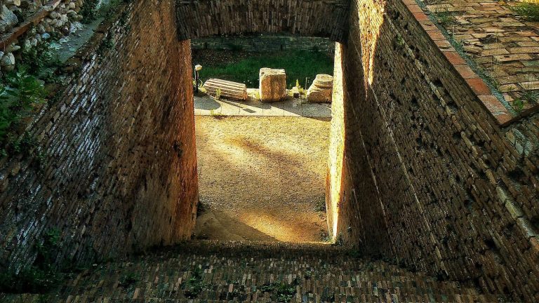
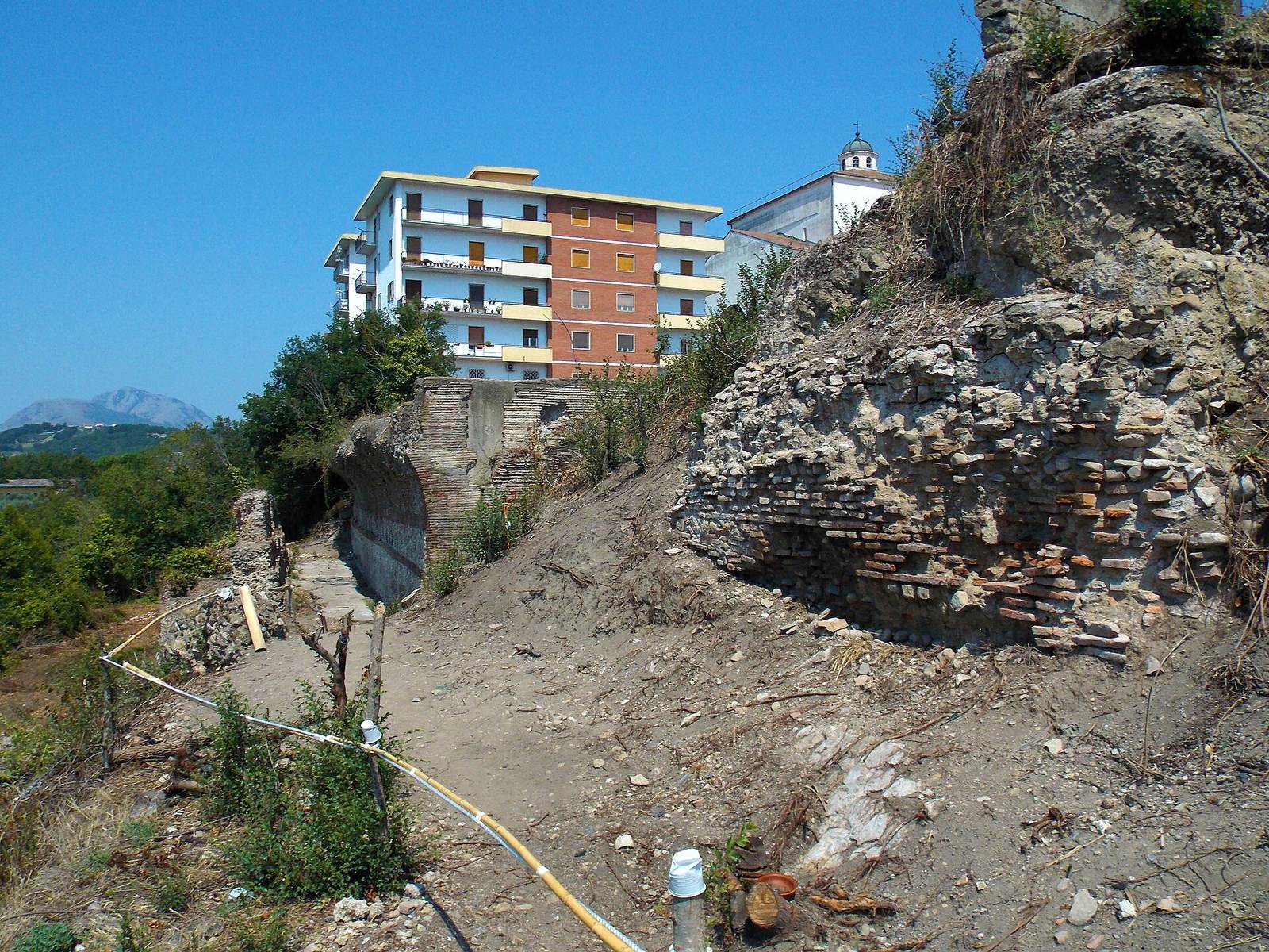
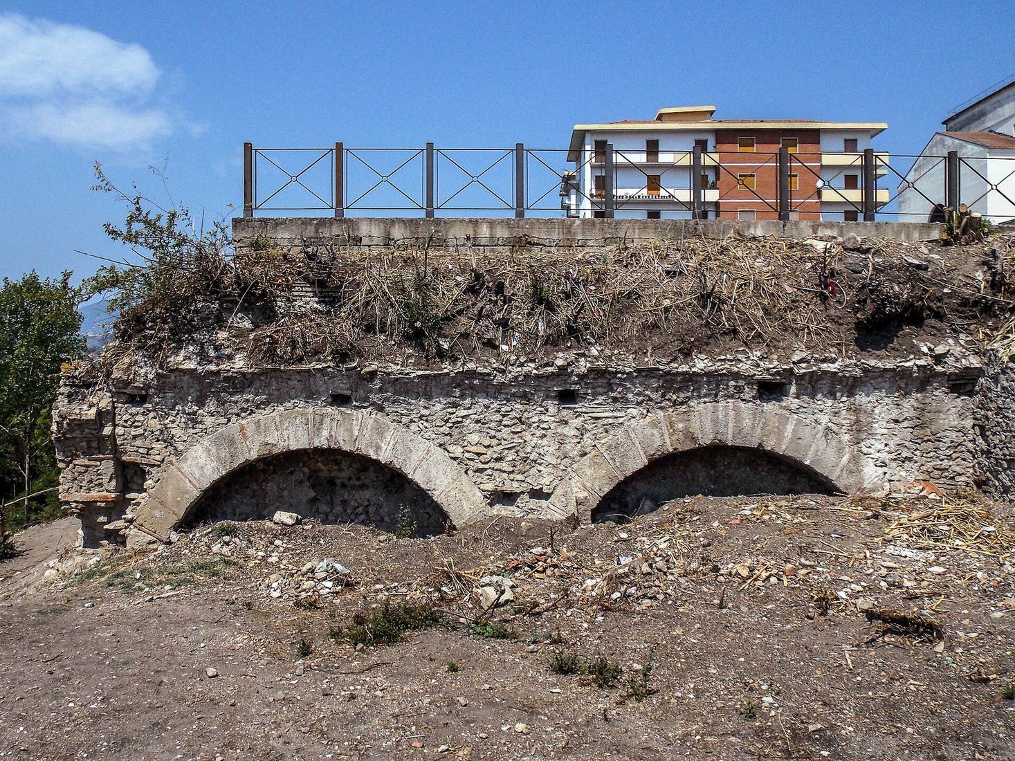
Santi Quaranta occupies the edge of a natural drop on ground rising from Cellarulo toward Benevento’s center. The complex, about 8 m high, served as a retaining structure; it faces the Leproso Bridge and lies beside the terrace on which the Basilica of Madonna delle Grazie stands. The visible Roman remains consist of a long corridor and two shorter passages joining its north side at nearly right angles and extending into the terrace. Their surviving and traced substructures indicate a much longer complex than the portion now visible.
Roman corridor system
Main longitudinal corridor
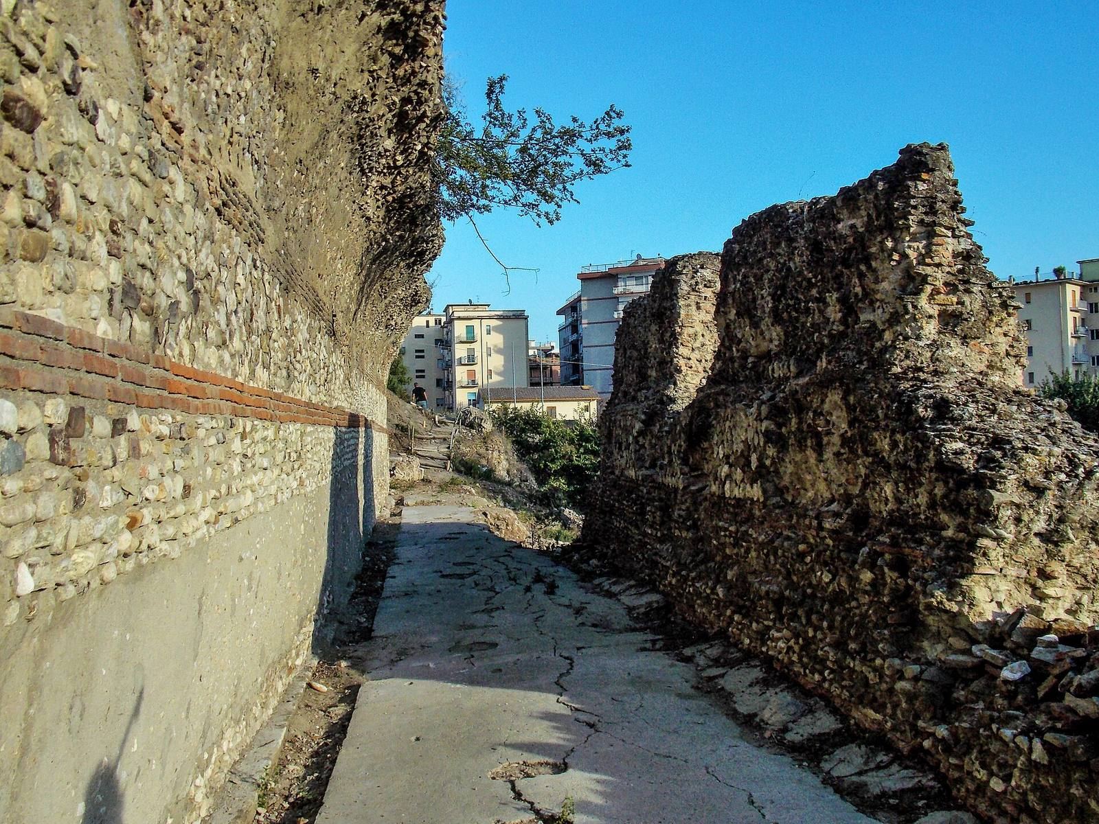
The surviving longitudinal corridor runs for 60 m on a WNW–ESE axis. Substructures traced at both ends continued along the same line, giving a combined length of 546 m with the surviving section. A vaulted space beneath a house on Via Luca Mazzella may belong to the complex; if so, its full length could have exceeded 600 m. The corridor was built in three stages: the central arm between the transverse passages came first, followed by the western arm, then the shorter eastern arm and its adjoining passage.
Walls, openings, and preservation
The southern exterior walls of the central and western arms stand on projecting supports above natural conglomerate. These supports were probably buried originally, but agricultural use lowered the ground at their base. The walls have six bands of small stones laid in a loose net pattern, backed by concrete and set above brick courses. On the highest band, the stone facing appears only on the outer side; the inner surface forms the outside of the former barrel vault. The earliest arm ends in a brick corner to the east, while its western end was cut back for the later extension. Setbacks above the third and fifth brick courses remain visible on both faces.
Three evenly spaced arched windows pierce the south wall of the central arm, and six pierce the western arm. Their arches and frames are brick, with toothed detailing on the exterior. The openings in the older arm begin at the uppermost brick course, which also forms their sills; those in the western arm extend down to the course below. The westernmost window was converted into an entrance, with an outside stairway leading down to the fields. A drainage channel opens at the western end of the north wall. The north wall of the western arm is preserved to the inner surface of the vault. Its opposite wall leans slightly and retains five bands of stone facing and part of a window; an external concrete support braces it. Fallen masonry remains at the building’s foot, and farther along the south wall survives to about half its original height.
The north wall of the western arm is thinner than its southern counterpart and rests against higher rock. Near the middle transverse passage, the north wall of the oldest arm was thickened with brickwork; the original wall may remain behind it. Near the eastern passage, that wall was cut back and set behind a newer wall of mixed construction. A blocked opening there may once have led to another short passage running parallel to the two surviving ones.
Middle transverse corridor
The middle transverse corridor is 3–3.30 m wide. It was described as about 17 m long, although more than 4 m at its far end are now buried. A dry-stone wall placed over fallen material marks its present end. Its visible brick facings may reinforce earlier walls of the same loose, net-patterned stonework. The corridor’s base follows the sloping ground: a concrete foundation descends from its far end toward the main passage. A raised edge beneath the eastern wall may mark the floor; on that interpretation, the passage stood 3.55 m high at its far end. Two drainage channels are buried.
The corridor’s roof was built in two stages. A small surviving section at the front appears to have been built with the visible walls, while the rear section uses limestone wedge-shaped blocks and bricks. This rear stretch is the only corridor vault still intact. Near the passage’s middle, a collapsed cross-vault and blocked wall openings suggest that two vaulted rooms may have extended in opposite directions, parallel to the main corridor. A ledge in the northeastern wall, 30 cm thick and 1.30 m high, turns as if it followed a blocked passage. It may have supported vessels for liquids, a possibility linked to the proposed storage function.
Eastern transverse corridor
The eastern transverse corridor is approximately as wide as the middle passage but shorter. It is now almost entirely filled with earth; its western wall and part of the end wall remain visible to their full height, bounding the embankment. The corridor was described as built in the same loose, net-patterned stonework. Three piers on its western wall support two arches, with a further arch at the entrance from the main corridor. A Roman brick pier remains beside that entrance, where the original wall of the longitudinal corridor was cut away.
The arches are probably Lombard in date and supported a replacement barrel vault beneath the church above. Their wedge-shaped blocks alternate tuff, rock formed from volcanic ash, and reused bricks. An entrance once reported beneath the first arch on the eastern wall is now buried or collapsed; it may have been added later and connected with the church. Irregular masonry below another arch may close one of the rooms suggested by the blocked openings in the middle corridor. A transverse wall is visible near the blocked entrance.
Upper rooms, burials, and later additions
Upper rooms and colonnade
Remains of several rooms survive at the upper level, approximately level with the Basilica of Madonna delle Grazie. One room followed the line of the middle transverse corridor. A larger room lay to its west, above much of the western arm and extending onto the terrace. Fragments of herringbone-patterned flooring and two column bases survive there, probably marking a colonnade above the north wall of the Roman complex. The upper room cannot be earlier than the western arm and may belong to the phase when the eastern transverse corridor was added. The colonnade was later incorporated into a continuous wall, parts of which remain. Steps led to a doorway between the surviving column bases. Remains of another room farther west may belong to the same building phase.
Burials
Three graves from late antiquity or the early Middle Ages lie in the western part of the larger upper room. Two have stone-lined burial containers made of tuff; the third is built from limestone blocks. They are thought to be associated with the church that stood above the Roman complex.
Agricultural structures
Small rooms intended for agricultural storage survive west of the corridors. They may have been built after the church fell out of use and remained in use until after the Second World War. Farther east, a wall made of pebbles and bricks extends to Via Ursus. It enclosed a portico during the complex’s agricultural reuse; nineteenth-century views show the portico, with the gallery entrance at its far end.