Saepinum: A Samnite and Roman Town in Italy
Site at a Glance
- Popularity
- High
- Country
- Italy
- Primary era
- Classical
- Eras represented
- Classical, Medieval
- Civilizations
- Kingdom of Naples, Roman, Samnite
- Site type
- City
On this page34 sections
History
Saepinum is the remains of a Samnite and Roman town on the Tammaro plain near Sepino, Italy. It probably began in the fourth century BC as a small settlement and market serving routes used for seasonal livestock migration, a practice known as transhumance.
Samnite settlement and Roman conquest
The settlement’s position near the Pescasseroli-Candela livestock route helped connect it with regional exchange. Coins from Campania, Epirus, and Illyria point to contacts reaching as far as the Aegean. Above the later town, the Samnite stronghold of Saipins occupied the hill of Terravecchia. In 293 BC, during the Third Samnite War, Roman forces led by consul Lucius Papirius Cursor captured the fort after strong resistance. Rome compelled the survivors to move down to the valley.
At the end of the Samnite Wars, a town grew on the plain, where farming and sheep raising supported trade and local crafts. By the early second century BC, production included leatherworking and wool processing. A major fire devastated the settlement toward the century’s end, after which buildings were rebuilt with improved materials and techniques, including bricks made in public and nearby kilns.
Roman civic life and prosperity
After the Social War of 91-88 BC, a revolt by Rome’s Italian allies seeking citizenship, Saepinum became a Roman municipium, a self-governing town whose inhabitants held Roman citizenship. Inscriptions attest to this status from the reign of Augustus, Rome’s first emperor. Saepinum’s citizens belonged to the Voltinia tribe, one of the divisions used for Roman civic registration. As Roman civic life took hold, traditional Italic cults disappeared.
During the first and second centuries AD, agriculture, livestock raising, crafts, and trade supported the town’s prosperity. In the Augustan period, public building and urban reorganization reshaped Saepinum. Inscriptions associate the construction of its walls, towers, and gates with Tiberius and his brother Drusus, while prominent local families, including the Neratii, contributed to public buildings and their maintenance.
Economic conditions worsened during the Flavian period, the rule of Vespasian and his sons from AD 69 to 96, and under Trajan, emperor from AD 98 to 117. Productive land and resources increasingly belonged to fewer owners. A magistrate responsible for funds supporting poorer families was appointed under Trajan. The Neratii continued to finance public works and repairs, including work on the basilica.
Late antiquity and abandonment
An earthquake in 346 damaged cities across Campania and Samnium, but building work continued at Saepinum. Between 352 and 357, provincial governor Fabius Maximus paid for public repairs, including work on the walls; his successor, Flavius Uranius, also supported improvements. In the later fourth century, Saepinum became the capital of the province of Samnium. It was an episcopal seat by the early sixth century and later came under the Lombard duchy of Benevento.
After Visigothic incursions, Emperor Honorius reduced Samnium’s tax burden in 413 to one fifth of its previous level. Bishop Proculeianus of Sepino attended a church council in Rome in 501-502. The Greco-Gothic War of 535-553, fought between the Eastern Roman Empire and the Ostrogoths for control of Italy, brought further decline. Parts of the walls and theatre fell, the forum stopped functioning, and extensive areas were deserted, although some of the town remained inhabited.
In 662, the Byzantine emperor Constans II, ruler of the eastern continuation of the Roman Empire, ravaged Saepinum during his conflict with the Lombards, and the bishopric was later suppressed. The town may have been repopulated under Lombard Duke Romoaldus. In 882, raids by Arab or Muslim forces, called Saracens in medieval European usage, led residents to take refuge at the hilltop settlement of Castellum Saepini, the predecessor of modern Sepino. The Roman town was then abandoned. The later name Altilia for the ruins comes from an Arabic term meaning “ruined city.”
From the eleventh century onward, people lived in the fortified hilltop settlement, while agriculture and seasonal herding were active again on the plain by the end of the thirteenth century. In 1309, under Robert of Anjou, the County of Molise ceased to be a separate feudal unit and became an administrative district of the Kingdom of Naples.
Excavation and preservation
Scholarly interest in the ancient town grew from the Renaissance onward. Excavations began in 1876, and a site plan was produced the following year. Work focused on the basilica in 1878 and continued intermittently through 1926. From 1950 to 1955, archaeologist Valerio Cianfarani led systematic investigations that uncovered and restored parts of the forum, basilica, walls, theatre, Porta Bojano, and buildings along the main street.
Excavations resumed in 1974, followed by restoration and consolidation work in the 1980s and 1990s, particularly around the forum and theatre. Work beyond Porta Benevento in 1981 revealed a fourteenth-century settlement and burials. Excavations begun in 2010 exposed almost the entire circuit of the Roman walls. Italy’s Ministry of Culture established the archaeological park of Sepino in 2021, granting it special autonomy and national-interest status.
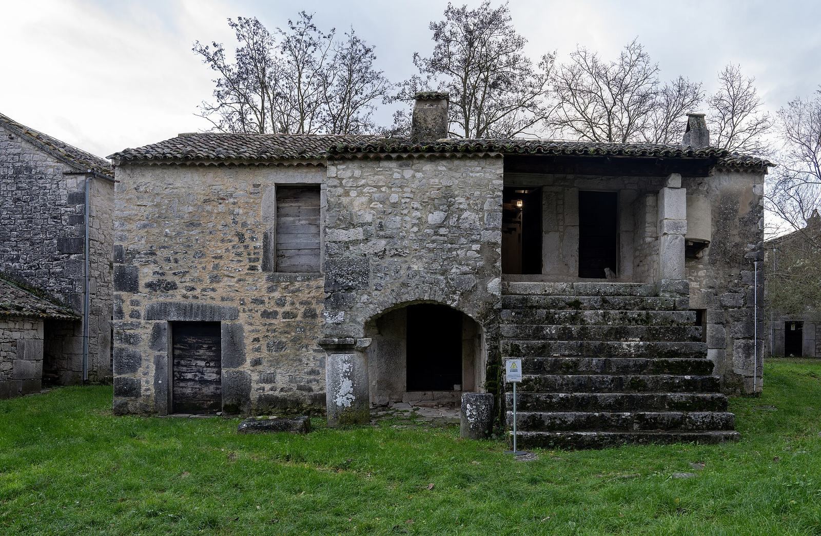
From the eighteenth century onward, rural houses were built on Roman ruins, reusing ancient masonry and foundations. Rather than removing them, archaeologists adapted these buildings as exhibition rooms, restoration workshops, and storage, and they now form part of the site’s documentary museum. Excavations at the house near Porta Bojano between 2023 and 2025 added evidence for the area’s earlier production use and its occupation into the Byzantine period.
Remains
Town plan and defenses
The archaeological area covers about 12 hectares within a roughly four-sided circuit with gently rounded corners. The ground slopes gradually from southeast to northeast. Existing routes shaped the street plan: the cardo, the principal street running southwest to northeast, and the decumanus, the principal street running northwest to southeast along the seasonal livestock route, meet at the forum.
Walls and towers
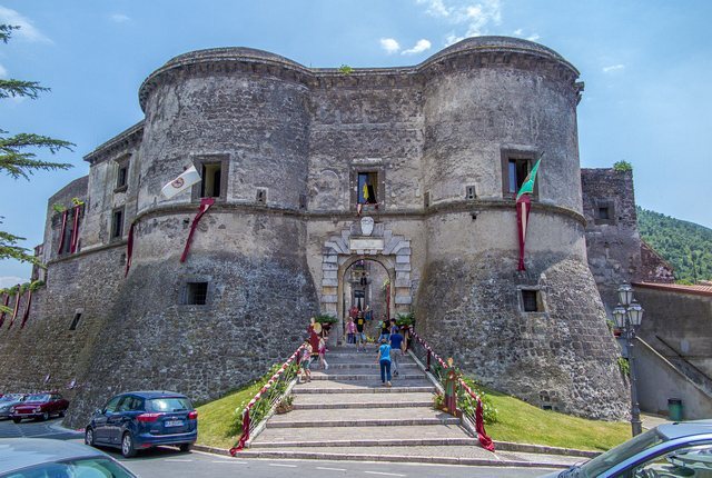
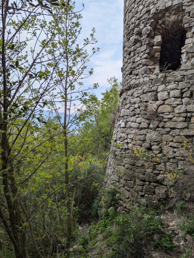
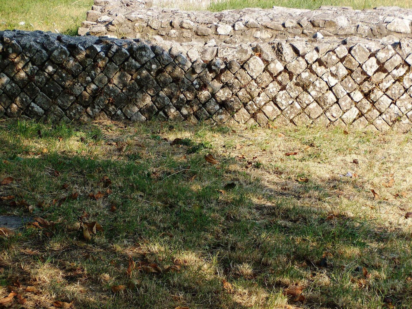
Built between 2 BC and AD 4, the walls extend for about 1,270 metres. Their straight sections use Matese limestone blocks faced in opus reticulatum, a net-like arrangement of small stones, and bonded with cement mortar. The wall face is about 1.80 metres thick and roughly 4.80 metres high, with a patrol walkway along its top. The original circuit included 35 circular towers, set about 24 to 37 metres apart; 19 are visible today.
The towers project about three metres on either side of the wall. Each is around seven metres across and nearly eleven metres high, with an outer facing of net-patterned masonry. Their interlocked construction shows that the towers and walls belong to the same building phase. Three openings on the outer face and three windows facing the town provided views in both directions. Some towers survive at their bases, while others include reconstructed upper sections made with ancient fallen stone.
Gate design
Four gates mark the entrances to the two principal streets. Each has a round arch about 4.8 metres high between circular towers and was equipped with a sliding wooden barrier operated from above. Beyond the entrance, an open rectangular defensive courtyard led to an inner double-leaf door. A stone stairway beside the entrance gave access to the wall walkway and gate mechanism. Inscriptions above the arches commemorate construction, and statues of captive “barbarians” and protective divine figures decorated the gates.
Porta Terravecchia
On the southwest side, Porta Terravecchia crosses the cardo and faces the Matese mountains and the route over Crocella pass. Its surviving remains include fragments of one flanking tower and the defensive courtyard. A carved block found nearby depicts a female deity, possibly Venus. It is now held in the Altilia documentary museum and may have formed part of the gate arch.
Porta Tammaro
Porta Tammaro stands on the northeastern stretch of the cardo, facing the Tammaro plain. A fragment of its northwest tower survives, together with traces of the defensive courtyard, façade decoration, and inscription. Some of the gate’s original masonry is incorporated into modern houses beside it.
Porta Benevento
Porta Benevento crosses the southeast side of the decumanus. Excavated in 1954-1955 and restored in 1972, it retains consolidated ancient masonry. About half of its northern tower survives. The southern tower is built in horizontal courses of stone blocks, rather than the net-patterned facing used elsewhere. Five original wedge-shaped stones remain in the outer arch, whose keystone bears a helmeted male deity, probably Mars.
Porta Bojano
On the northwest side of the decumanus, Porta Bojano was excavated from 1928 and consolidated; its two flanking towers were reconstructed by 1955. The arch rests on substantial squared-stone supports and carries a commemorative inscription, with two symmetrical figures of captives on its exterior. Eighteen wedge-shaped stones form the outer arch ring, and a carved keystone shows a bearded male figure generally identified as Hercules. An inscription near the gate, dated to about AD 168, protects passing shepherds and the seasonal livestock routes.
Forum and civic buildings
The forum occupies the junction of the cardo and decumanus, at the center of the town’s civic and commercial life. Buildings and paved areas around it include the basilica, a food market, baths, and other public structures.
Forum paving
The plaza is trapezoidal and covers about 1,412 square metres. Its northwest and southeast ends measure 29.56 and 23.25 metres across, while its northeast and southwest sides are 53.90 and 53.13 metres long. The long edges draw slightly closer together toward the southeast. Flat limestone slabs form 82 parallel rows. The pavement slopes toward a drainage channel along the eastern and southern sides, and a drain beside the cardo joins the sewer system.
An inscription in the paving names the magistrates who paid for it, including Gaius Papius Faber. A dedication to the deified Augustus shows that the paving was laid after AD 14. Its stones were reassembled and levelled between 1952 and 1955.
Basilica and raised hall
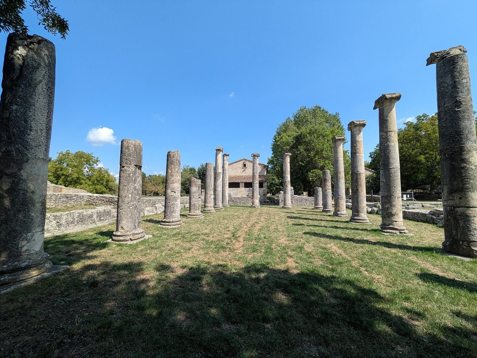
The rectangular basilica closes the northwest side of the forum and measures 31.60 by 20.40 metres. Twenty columns with smooth shafts and Ionic capitals surrounded its central space, measuring 19.50 by 9 metres, with a 3.60-metre-wide passage around it. The building’s main façades align with the two principal streets. Each had a central doorway 2.50 metres wide and two flanking doorways 1.75 metres wide. The walls, built from irregular limestone blocks bonded with mortar, are about 60 centimetres thick and survive to a maximum height of 1.10 metres.
Restoration in the 1950s rebuilt nine columns to a height of 6.15 metres; ten Ionic capitals survive. An inscription naming Lucius Naevius Pansa, regarded as the basilica’s founder, remains in place. Fragments of an inscription dated AD 80 may have stood above the main entrance, and the building also preserves traces of later ancient repairs.
A raised hall, accessible only from inside the basilica, is thought to have served as a platform for magistrates carrying out official duties. Two doors and three steps led to a rectangular entrance room, about 8.45 by 3 metres, and a central passage opened onto a raised hall measuring 14.85 by 9.60 metres. A later semicircular end was added, with the side walls extended and joined by a new rear wall. Inscriptions record fourth-century renovation, including marble decoration sponsored by provincial governor Flavius Uranius. The altered hall may later have been used for Christian worship, though this interpretation is uncertain.
Food market
The macellum, or food market, stands beside the basilica and opens onto the decumanus. A raised entrance is reached across a paved strip 2.75 metres wide. A short corridor leads to a central hexagonal room paved with irregular white limestone pieces, with four openings leading into shops that retain their original brick floors. A reused millstone forms a basin in the center.
An inscription names Marcus Annius Phoebus as the market’s benefactor and describes a courtyard colonnade decorated with bronze and marble. The building probably dates to the first decades of the first century AD and was restored in the second half of the fourth century. Its perimeter walls were restored in 1958.
Other buildings around the forum
Beside the market is a nearly square building measuring 8.70 by 9 metres, probably used for worship. Its entrance porch, about seven metres deep, contains a square basin lined with coloured marble and a covered channel toward the decumanus. Two raised steps lead through a monumental entrance to an interior with a marble-covered platform about 90 centimetres high, possibly intended for cult images. The structure dates no later than the first century AD; much of its visible wall surface and height reflects modern restoration.
Other buildings on the forum’s northeast side include a rectangular room tentatively identified as either a council house or a meeting place for public assemblies. Nearby, a public building measuring 12 by 7.8 metres is divided into two rooms with different limestone and durable terracotta-mortar floors. A central temple platform, probably dating to the early first century AD, measures 10.50 by 9.25 metres and is approached by a ramp measuring 9.90 by 3.20 metres. A stone marker on the ramp is dedicated to Constantine. The temple may have been dedicated to Jupiter Optimus Maximus, chief god of the Roman state. Connected watertight basins beneath it belong to an earlier wool-processing workshop. A further room, probably used for imperial worship in the third or fourth century, contains a statue and dedication to Helena, Constantine’s mother.
Rooms and fountain on the southeast side
Four rooms excavated in 1976 share a rear wall and open toward the forum. Their floors include red stucco with coloured mosaic pieces, a patterned floor made from cut marble and other stone, and a black-and-white mosaic. A central drain occupies the fourth room. The rooms’ functions remain uncertain.
A nearby square fountain measures about 6 by 6 metres. It has a rear basin, limestone paving, and surviving bases for roof supports. An inscription in bronze letters names the magistrates who paid for its construction.
Theatre, baths, and fountain
Theatre
The theatre stands in the northern part of the town against the wall between Porta Bojano and the northern corner. It is set slightly obliquely to the wall so that its crosswise axis and entrances align with the cardo, about 60 metres away. Dated to approximately AD 14-68, it had a seating area about 63 metres wide, a central performance space around 13 metres across, and an estimated capacity of 2,500 to 3,000 people. Eighteenth-century rural houses were built over the upper seating area.
Large public baths
The large bath building lies opposite the forum, across the decumanus. Its exposed section measures 28.30 by 19.25 metres. A portico 18.50 metres long and 3.40 metres deep faces partly toward the forum and partly toward the road; five limestone column bases remain. The interconnected, symmetrical rooms, curved walls, and nearby drainage system support its identification as a bath complex.
The walls are generally about 60 centimetres thick and use irregular stone facing bonded with mortar; the wall of an apselike recess is 90 centimetres thick. The building probably dates to the late first or early second century AD. Inscriptions associate it with the Baths of Silvanus and record repairs between 352 and 357.
Smaller bath complex
A smaller bath complex was found in 1955 against the inner wall between Porta Bojano and the theatre. Dating to the second century AD, it includes rooms parallel to the decumanus, channels in the walls for hot air, and an underfloor heating system in which hot air circulated beneath the floor on brick supports. An external furnace supplied heat, while bathing basins provided water at different temperatures. Impressions of the small pieces that formed the first room’s mosaic floor remain in the concrete beneath it.
Griffin Fountain
The Griffin Fountain stands beside the northeast side of the decumanus, about ten metres from the forum, between the baths and a private house. Its relief depicts a griffin with folded wings, with a water outlet below its chest. The rectangular basin measures 3 by 1.85 metres and has an 89-centimetre-high parapet. Channels carry overflow to a drain.
An inscription credits Caius Ennius Marsus and his son Lucius Ennius Gallus with paying for fountains. The structure dates to the period when the town walls were built. In 1973, missing sections were supplemented with Guardialfiera limestone that was intentionally distinguishable from the ancient stonework.
Houses and workshops
House near Porta Bojano
The house near Porta Bojano has a monumental entrance opening directly onto the decumanus. Geophysical surveys indicate that the excavated area represents less than the full extent of the building. Beneath the residence are rooms and basins belonging to a production building of the second or first century BC, probably used to process wool. The house itself dates to the first century AD, flourished in the second and third centuries, and was converted to production or storage uses between the fourth and sixth centuries.
A system for heating domestic water included a large cylindrical lead vessel decorated with raised sun motifs and Gorgon heads, mythological female monsters often shown with snakes for hair. Bronze pipe and valve fragments were also found. Other finds include coins, lamps, small ceramic vessels, bronze rings, a small chest key, a terracotta incense burner, marble architectural fragments, and about 400 stone blocks from the forum. A hoard of fifth-century coins came from near the main street.
Houses and shops along the decumanus
Between Porta Bojano and the forum, remains of houses and shops line the decumanus. Shops generally faced the road, with living rooms behind them. Irregular traces of columns suggest that a colonnaded walkway and raised galleries may have extended along parts of the street. Raised stones provided crossing points over the roadway. The modest materials and straightforward building forms suggest a working neighbourhood, whose original layout may predate Augustus.
House of the Samnite Impluvium
Beneath Roman-period construction in the House of the Samnite Impluvium is a terracotta rainwater basin from the second century BC, bearing an inscription in Oscan, the language of the Samnites. The Roman house has a slant-sided plan measuring 14.60 by 17.85 metres, with its long sides aligned with the cardo. Two shops, each 5.30 by 6.23 metres, flank the entrance corridor; the left-hand shop retains its sales counter.
The corridor leads to an atrium, the house’s central hall or courtyard, with a limestone basin for collecting rainwater. Rooms open onto the courtyard, and sections of stone and terracotta flooring survive. The building may have had an upper storey. An adjoining structure has been interpreted as a watermill because a narrow lined channel may have held a waterwheel, though the remains do not settle the question.
Workshop with terracotta vats
A workshop complex along the decumanus contains a shop facing the street, a courtyard, a living room, and a work area with five large terracotta vats linked by surface channels. It was first identified as an olive press, but is now more likely to have been a tannery; that interpretation remains tentative.
Burials and structures beyond the walls
Burials in the forum
Late antique and early medieval graves occupy parts of the forum. Seventeen substantially intact burials were found near its northern end, representing people of different ages and sexes. Some bodies were laid directly on the ancient paving with their heads to the east. Stone slabs lined or covered the graves. The cemetery dates to the sixth and seventh centuries.
Fourteenth-century settlement
Beyond Porta Benevento, excavations in 1981 uncovered a fourteenth-century settlement built with reused Roman stone. Its dry-stone walls rest on large foundations. Nearby graves show both burial and cremation practices: some bodies were placed in wooden coffins, while cremated remains were kept in lidded urns inside wooden boxes.
Mausoleum of Caius Ennius Marsus
About 75 metres beyond Porta Benevento, the mausoleum of Caius Ennius Marsus takes the form of a raised burial mound. It was rebuilt and heightened in the 1940s, largely with ancient pieces. Its square base is 10.12 metres wide and about 1.80 metres high, and contains the foundations of an eight-sided burial chamber. Above it, a cylindrical section measures 8.40 metres across and 3.30 metres high, with moulded cornices and a crenellated top.
Stone lions once stood at the base’s corners; two damaged examples survive, and a third is in the museum. The façade inscription lists Marsus’s civic and military offices. Reliefs below depict a magistrate’s folding chair, a document box, and a footstool.
Mausoleum of Publius Numisius Ligus
About 70 metres outside Porta Bojano, the mausoleum of Publius Numisius Ligus is made from local white limestone and has been almost entirely reconstructed with ancient material. Its altar-like form has a base 2.40 metres high and measuring 3.88 by 5.40 metres, supporting an upper block 3.90 metres high, 3.25 metres wide, and 2.75 metres long. Plant-decorated ornaments rise at the corners of the upper cornice, and a small doorway at the rear gives access to the interior. A framed inscription on the front commemorates Ligus, his wife Vannia Quarta, and their son.