Rothenberg Fortress: A Bavarian Rococo Stronghold near Schnaittach



Site at a Glance
- Rating
- 4.3
- Popularity
- Low
- Country
- Germany
- Primary era
- Early Modern
- External website
- Open
- Eras represented
- Medieval, Early Modern
- Civilizations
- Holy Roman Empire, Kingdom of Bohemia
- Site type
- Military
- Remains
- Fort
On this page19 sections
History
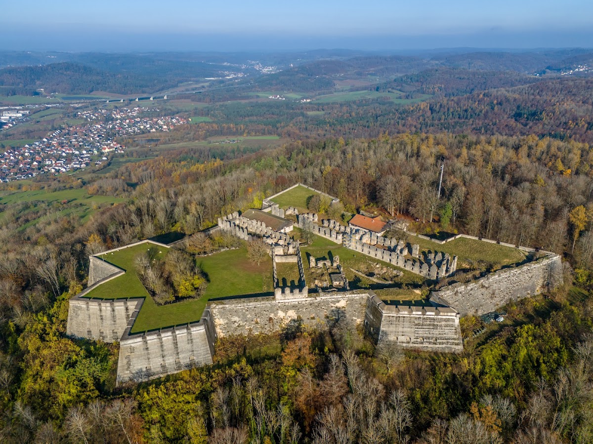
Rothenberg Fortress is a former castle and fortress in Germany on the 588-metre Rothenberg near Schnaittach. The present fortress was built in the eighteenth century as a major Rococo fortification in the French manner, replacing an earlier medieval stronghold. Its history includes imperial frontier defense, joint noble ownership, religious conflict, Bavarian military rule, and eventual abandonment.
Early castles on Rothenberg
Rothenberg may have been occupied by Celtic groups during the Hallstatt period, an early Iron Age cultural period in Central Europe, around 600 BC. They may have established an oppidum, a large fortified settlement usually associated with Celtic communities, although this possibility remains uncertain. The date of the first medieval fortification on the mountain is also unknown.
The earlier Alter Rothenberg castle site lies northwest of the present fortress. The Lords of Rothenberg were first recorded there in 1254, but their line died out during the thirteenth century. The castle then passed by marriage to the Wildenstein family. It was probably destroyed during a feud, after which a replacement was built on a different elevation.
Dietrich von Wildenstein probably established a summit castle on the present Rothenberg between about 1300 and 1330. In 1360, the Wildenstein family sold it to Charles IV, Holy Roman Emperor and King of Bohemia. Charles IV expanded the castle into a border stronghold intended to protect his hereditary Bohemian lands and the lordship of Neuböhmen.
The castle settlement and its destruction
Under imperial ownership, a settlement grew outside the castle walls. It acquired a church, parish house, cemetery, enclosing wall, moat, 26 towers, and later a town hall, becoming the town of Rothenberg. The castle could be reached only through this settlement, which formed part of its defensive arrangement.
After Charles IV’s successor Wenceslaus was deposed as German king by four electors on 20 August 1400, King Rupert of the Palatinate and forces from Nuremberg attacked Rothenberg. Following a five-week siege, they captured and devastated the castle and settlement in 1401. The rebuilding that followed under the Wittelsbach family is uncertain.
Nuremberg besieged the fortification again during the First Margrave War of 1449–1450, but failed to capture it. The settlement was almost completely destroyed. Its exposed position and shortage of water prevented reconstruction, and its inhabitants were apparently resettled at Schnaittach. The abandoned area became known as the Old Town.
The Ganerbenburg
In 1478, Count Palatine Otto II established the conditions for Rothenberg to become a Ganerbenburg, or jointly held castle administered by multiple co-vassals. Initially, 44 co-vassals, later 133, acquired the castle, the remains of the town of Rothenberg, and the market town of Schnaittach as a mesne fief, a fief granted by an intermediary lord who held it from a higher authority.
The co-vassals received relatively little property and few rights, but their alliance could admit other noble families from the surrounding area. The community also held several rights of patronage in the Nuremberg region and functioned as an Einung, a sworn alliance formed for mutual political and territorial protection. Its members appointed burgraves from among themselves. Recorded holders included Heinz von Guttenberg in 1483, Lamprecht von Seckendorff and Hans Zollner von Rottenstein in 1487, Dietz von Heßberg in 1488, and members of the Stiebar, Seckendorff, Sparneck, Gotsmann, Thann, Eyb, Schaumburg, Steinau, and Rotenhan families in later decades.
Nuremberg soon became the principal enemy of the co-vassals. After the Rothenberg territory became an enclave within Nuremberg lands during the Landshut War of Succession, treaties concluded in 1523 and 1540 established the border and largely settled the territorial disputes.
The co-vassals used their patronage rights to introduce the Lutheran confession in 1529, four years after Nuremberg had adopted it. During the Thirty Years’ War, Maximilian of Bavaria received Rothenberg as an imperial fief and demanded its return to Catholic worship. The co-vassals refused, so Maximilian exercised his right of occupation and seized the fortress. Having lost effective control, the co-vassal community sold Rothenberg to Bavaria for 200,000 gulden.
Bavarian fortress and eighteenth-century wars
Bavaria renovated and strengthened Rothenberg after acquiring it. During the War of the Spanish Succession, a conflict over the Spanish monarchy and the European balance of power, a siege was deliberately provoked to keep imperial troops occupied. Fleeing civilians and a cavalry unit unexpectedly entered the fortress, however, consuming supplies more quickly than expected. The garrison capitulated in September 1703, and Nuremberg ordered the fortress slighted in October. A gold ducat commemorating Nuremberg’s conquest was minted that year.
Rothenberg remained a Bavarian enclave after the war. From 1720, the ruins of the former fortress were dismantled, and construction of the present fortress began under Elector Charles Albert of Bavaria in 1729. The work was largely complete by 1743. A Bavarian garrison returned in 1740 after being stationed at Schnaittach from 1715.
During the War of the Austrian Succession, Austrian Habsburg forces attempted to capture Rothenberg in 1744 but failed. A mine was prepared for detonation beneath the defenses when the approach of French troops prevented the operation. The Franconian Imperial Circle remained neutral, supplied the fortress with weapons, and allowed Austrian forces to cross its territory.
Loss of military importance
Rothenberg did not actively participate in the Coalition Wars, although troops passing through the region were allowed to use it. In 1796, control changed several times between France, Austria, and Bavaria. After the Third Coalition War, the dissolution of the Holy Roman Empire, and Bavaria’s entry into the Confederation of the Rhine, Napoleon transferred part of Franconia to Bavaria. Rothenberg consequently ceased to be a Bavarian enclave.
After 1806, the fortress no longer served as a border defense. It was used as a fortress prison and as an institution for elderly veterans and invalids. Financial pressures led to the withdrawal of most soldiers, leaving a small guard, nursing staff, and administrative officials. Earlier, some soldiers had lived inside the fortress with their families.
By 1838, seepage and collapses in the casemates required repairs that the authorities were unwilling to finance. King Ludwig I secured the fortress’s decommissioning that year. The Bavarian War Ministry then sold its removable inventory, including doors and beams. The last three soldiers left in 1841 after supervising the dismantling, and the abandoned site deteriorated and served as a quarry. Stone from Rothenberg was also used in the construction of Nuremberg Central Station.
Ruins, conservation, and later uses
The fortress grounds passed to the Bavarian forestry administration and were planted with trees. Explosive demolition tests were carried out on the ravelin in 1876. During the late nineteenth century, the ruins became a popular excursion destination as the railway network developed. From 1898, the Schnaittach Heritage and Beautification Association, now the Schnaittach Heritage Association, cared for the site.
Tourism developed alongside local agriculture, first sheep farming and later hop cultivation, with paths and catering establishments added around the ruins. The First World War interrupted this development. A National Socialist plan to build an Ordensburg, a training and ideological complex for political and administrative elites, was abandoned because a reliable water supply could not be secured.
A flight-observation post operated on the mountain from 1940 to 1943. Winter sports briefly returned after the Second World War, bringing ski slopes, a Bavarian Red Cross shelter, and a ski-jumping hill. A landslide destroyed the ski jump in 1972. Administration of the actual fortress ruins passed to the Bavarian Palace Administration in 1966. Conservation work undertaken jointly with the Schnaittach Heritage Association was substantially completed in 2008. The underground casemates also serve a nature-conservation purpose and are closed during the bat-protection period.
Remains
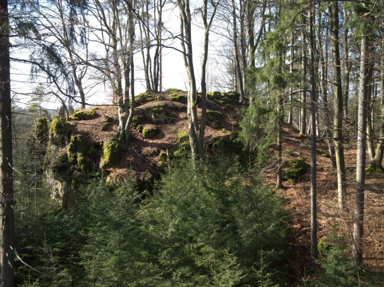
Rothenberg’s surviving remains combine the layout of a medieval Veste, meaning a fortified castle or stronghold, with the geometric earthworks and masonry defenses of an eighteenth-century fortress. The medieval complex occupied a plateau divided into a main castle, an outer bailey, and the open area of the former town. The later fortress was built over the smaller earlier stronghold and preserved parts of its walls and defenses within the new casemate structures.
The medieval castle complex
Main castle
The medieval main castle stood in the southern part of the plateau and was enclosed by a pentagonal curtain wall. Its central building was the palas, the principal residential and representational building of a medieval castle, known at Rothenberg as the Red House. The main-castle area also contained a smithy, kitchen, bake oven, well, and open space. A gate fitted with a drawbridge connected the main castle with the outer bailey.
Outer bailey and town
The outer bailey held workshops, servants’ and armed retainers’ living quarters, a chapel, stables, and a brewery. Its curtain wall included a zwinger, an outer defensive space between fortifications. The former town area contained service buildings and a well, together with possible kitchen gardens and fruit trees. Its walls were reused as an enclosure and later partly replaced by wooden palisades.
Neck defenses
A broad neck ditch separated the two castle sections and was used to keep deer. Its central tower, called the Gänsbauch, commanded almost the entire site. Remains of the tower, the wall dividing the main castle and outer bailey, and the inner neck ditch were incorporated into the casemate hall of the later fortress. Two bastions and another neck ditch closed the complex on the north, where the curtain wall was weakest. An additional earthwork and covered way strengthened this side. The medieval Veste apparently had no keep.
The original appearance of the medieval castle is unknown. Pictorial representations begin in the sixteenth century, including views published in Matthaeus Merian’s Topographia Franconiae of 1648.
The eighteenth-century fortress
Defenses and casemates
The present fortress follows geometric bastion principles in a polygonal plan, with a bastioned tower at each corner. A bastion is a projecting defensive work. The star-shaped bastions reduced blind spots, while the low rampart crest limited the target presented to artillery. On the north side, a gently rising glacis, or sloping earthwork that shields a fortification, led to a covered way, moat, and main rampart. The main rampart rose only slightly above the glacis, which concealed it from direct artillery fire.
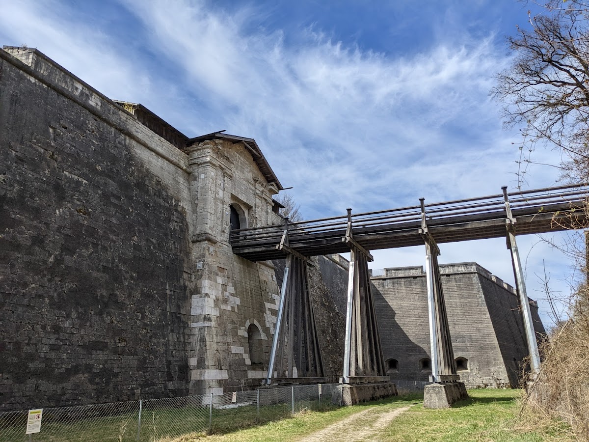
The ridge protected the fortress from storm attack on the south, east, and west, but did not shield it from the powerful siege artillery of the period. A ravelin, an outwork placed in front of a curtain wall, protected the north main curtain. All bastions and curtains except the main curtain contained casemates, vaulted chambers used for protected military or storage purposes. A central casemate hall lay beneath a five-metre layer of earth and was described as bombproof.
The fortress was built entirely of rubble-stone masonry. Its enclosing walls were about 16 metres high, while the interior vaults reached approximately 10 metres in height. The bastions were named for Charles Albert, his wife Maria Amalia, Glatzenstein mountain, Kersbach, Nuremberg, and Schnaittach. Charles Albert and Maria Amalia are said to have laid the foundation stone in 1731.
Buildings within the fortress
The interior included two two-storey barracks, the Artillery Barracks and Infantry Barracks, as well as an arsenal, engineers’ house, gatehouse, commandant’s headquarters, and church. The garrison sometimes lived inside the fortress with family members. These buildings formed the administrative, residential, and military core of the rebuilt stronghold.
Outer service areas
Supply and service buildings occupied the area of the former town and the surrounding slopes. They included a powder magazine, laundry with a washing pond and bleaching meadow, horse pond, shepherd’s hut, quarry with lime pits, utility and ornamental gardens, guardhouse, and drill ground. A local road connected these installations with the fortress. The buildings have disappeared, while foundation remains and ditches survive.
Cemetery and water system
Fortress cemetery
A cemetery southeast of the fortress was used from 1740 to 1843. It contains the burials of 1,083 fortress occupants and their family members. In 1927, the Schnaittach Heritage Association restored the cemetery by moving the surviving gravestones into their present arrangement.
Schneckenbrunnen waterworks
Water supply on the summit plateau was difficult despite numerous natural springs. A deep well tapped groundwater during the castle period and was later used by the fortress. Seven springs beneath the former town were connected to increase their flow and incorporated from 1760 into the Schneckenbrunnen, a water-collection and storage system.
The Schneckenbrunnen included a collector tunnel more than 40 metres long. It gathered spring water and directed it to a draw-well shaft. A second shaft with a spiral staircase gave the installation its name and allowed the water level to be checked. An overflow carried excess water toward the slope.
Outside the fortress walls, the well system was protected by a counterguard, an outwork named for Max Joseph and built of rubble-stone masonry. A planned underground passage connecting the counterguard with the fortress was never completed. When the fortress was decommissioned, the well shaft was filled in and, after the Second World War, sealed with a concrete cover.
Between 1987 and 1989, the Höhle und Karst Franken research group removed rubble and accumulated water, located the overflow, and restored the flow of water. The Schneckenbrunnen remains in nearly intact structural condition, with frost damage near the top of the shaft and mineral deposits in the collector tunnel. It can again supply approximately 4,000 litres of water per week.
Objects recovered while the well shaft was cleared include a gold-mark coin, stiletto, two harmonicas, stone marbles, fire-marked bricks, a knife, ceramic fragments, forged nails, and a barrel hoop. Copperplate engravings from 1838 also show that collecting rainwater was an important part of the fortress’s water supply.