Pfünz Roman Fort: A Roman Cohort Fort in Bavaria
Site at a Glance
- Popularity
- Medium
- Country
- Germany
- Primary era
- Classical
- Eras represented
- Classical, Modern
- Civilizations
- German, Roman
- Site type
- Military
- Remains
- Fort
On this page21 sections
History
Pfünz Roman Fort was a Roman cohort fort in Bavaria, Germany, near the village of Pfünz. Probably established around AD 90 as a timber-and-earth camp, it stood on a spur between the Altmühl and Pfünzer Bach valleys, about 11 km behind the Rhaetian Limes, Rome’s frontier in Raetia. The fort guarded a nearby river crossing and road junction and helped secure a stretch of frontier about 10.2 km away.
Foundation and imperial service
The first camp was probably built while a road was being constructed between the forts at Kösching and Weißenburg. One interpretation is that the frontier temporarily followed this road, placing Pfünz on the border. After the frontier was extended to its final line under Hadrian, the fort served farther behind the boundary. It may also have supplied the garrison for the smaller fort at Böhming.
The garrison was the First Cohort of the Breuci, a unit of Roman citizens combining infantry and cavalry, with roughly 500 troops. A military diploma probably found in Bulgaria records the cohort in Raetia by May 13, AD 86, but does not establish that it was already at Pfünz. At that time Titus Flavius Norbanus commanded the Raetian army.
During the reign of Antoninus Pius (AD 138–161), the fort was rebuilt in stone. An inscription found at the west gate in 1888 names the emperor and the cohort but gives no exact construction year. Features of the headquarters building also place the stone rebuilding broadly in the first half of the second century.
In AD 181, the Pfünz garrison helped a construction detachment from the Third Italic Legion rebuild the smaller fort at Böhming for a unit of auxiliary troops. The work may have followed damage in the Marcomannic Wars, second-century conflicts between Rome and Germanic peoples that included the Marcomanni. Legion personnel built the gates, towers, and defensive walls, while the Pfünz soldiers worked on the buildings inside. An inscription at Böhming names Aelius Fortis, the cohort’s commander at Pfünz that year.
A further refurbishment followed roughly three decades after the stone rebuilding. An inscription dated AD 183 or 184 names Emperor Commodus and the provincial governor Spicius Cerialis, but it is unclear whether it records routine repairs or restoration after war damage. Archaeologist Thomas Fischer tentatively connected a separate inscription, known from loose bronze letters, with Emperor Caracalla’s inspection tour after his victory over the Alamanni in AD 213.
Destruction and the end of the fort
Excavations identified two destruction layers at the gates. The earlier one has been attributed to a Marcomannic attack. The fort’s final destruction was sudden and took place during the third century. Dates proposed for it include about AD 230, the Alamannic incursions of AD 233 or 234, and about AD 240; a cautious estimate places it around the middle of the century. The Alamanni were a confederation of Germanic groups that fought Rome.
Evidence from inside the fort suggests that the final attack surprised its occupants. Finds associated with the destruction include shields in a tower by the south gate, human remains in that gate’s southern tower, and a prisoner’s leg bone still caught in an iron chain at the headquarters. The remains have been interpreted as signs of a violent capture. Historian Lawrence Okamura proposed another possibility: the garrison may have mistaken its attackers for Roman troops and opened a gate during civil conflict following Maximinus Thrax’s rise to power in AD 235. This explanation remains unproven. Coins from the nearby settlement extend into the reign of Gordian III (AD 238–244), so the destruction cannot be securely dated to AD 235.
The fort was not demonstrably rebuilt or occupied again before Rome’s final abandonment of the Rhaetian Limes around AD 259 or 260. The adjacent civilian settlement and its infrastructure were destroyed in the same period.
Settlement, worship, and modern investigation
A civilian settlement grew beside the fort, with homes, religious buildings, a cemetery, and a district of workshops. Some residents had heated floors and imported fine tableware. Three temples were identified. One was dedicated to Jupiter Dolichenus, a Roman military deity whose cult began in Doliche in Asia Minor. Worship of the god declined after AD 235, when the Severan dynasty ended, and many of his sanctuaries were abandoned or burned. The identities of the deities associated with a circular temple at the settlement’s southern end remain conjectural.
Inscriptions also preserve evidence of religious practice and military personnel. A dedication to Sedatus, a deity of Illyrian origin, records the cohort’s fulfilment of a vow under cavalry officer Julius Maximus. A dedication to Fortuna Redux, a Roman divine title associated with safe return from travel or military campaigns, was found at Böhming; it records a vow by the Pfünz cohort under Laetus in AD 215 and may refer to a successful military action. Other inscriptions name cohort commander Publius Crepereius Verecundus, cavalry officers Flavus Alpinus and Flavus Norsanus, and infantry centurion Crispus Paternus.
Johann Nepomuk von Raiser excavated at Pfünz in 1809, finding a building he identified as a temple, Roman dwellings, and burial mounds. Friedrich Winkelmann began work in 1884, and, with Karl Popp, Friedrich Ohlenschlager, and Hugo Arnold, led extensive excavations that continued until 1900. Sections of the fort wall were restored and exposed after this work. St. Nicholas’s church, built with reused Roman stone near the fort, was moved to the village in the early sixteenth century; its former building later fell into ruin and was demolished in the nineteenth century.
Further repairs and investigations followed. Exposed foundations were secured in 1954 and 1955, limited wall sections were reconstructed in 1960, and the north, south, and west gates were conserved in 1987 and 1988. Test excavations accompanied a water-line project in 1998. A geomagnetic survey in 2000, using variations in ground magnetism to identify buried features, was analysed in 2007 and helped guide later excavation. Aerial photography in 2010 revealed a large building outside the fort, subsequently surveyed; archaeologists proposed that it was a roadside inn with a station for changing transport animals.
The fort and its associated remains form part of the Rhaetian Limes, included since 2005 in the UNESCO World Heritage property Frontiers of the Roman Empire, shared with the Upper German frontier. The remains are also protected as registered archaeological monuments under Bavarian law.
Remains
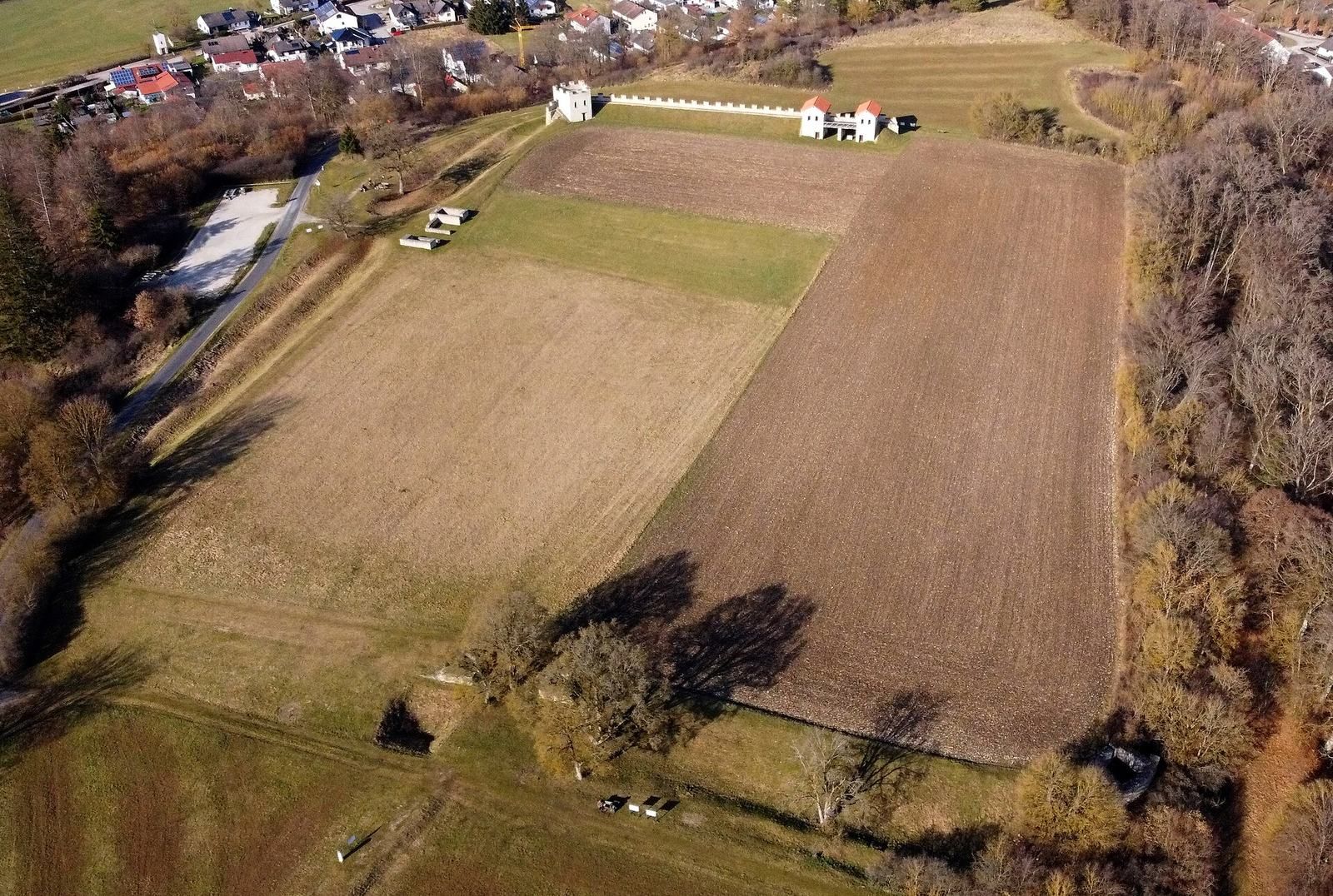
The fort occupies a steep, north-facing spur of the Jura upland, about 42 m above the valley floor and approximately 425 m above sea level. Its north–south plan follows the spur, overlooking the lower Pfünzer Bach valley, an ancient river crossing, and nearby valley ground. The raised outline of its stone defensive circuit encloses a slightly skewed rectangle, while remains of the settlement and its facilities extend into the valley and south along the road.
Fort layout and defenses
Plan and orientation
The fort measured about 189 m by 145 m, with some measurements giving 187 m by 144 m, and covered approximately 2.5 hectares. Its shape was a skewed rectangle, or parallelogram. The main roads converged toward the centre, and the buildings were set at corresponding angles. The outline can still be seen as a raised bank.
Walls, towers, ditches, and gates
The defensive wall had rounded corners, each with a tower. The excavated northwest tower survives to about 0.5 m high. Its outer wall was roughly 1.2 m thick, while its side walls and inward-facing wall measured between 0.85 and 1 m. Excavators also identified an intermediate tower in the southeastern part of the fort’s rear half.
Each of the four gates had two passageways between a pair of towers. Double V-shaped ditches followed the rounded corners and ended at the gates. The southern side instead had one exceptionally broad and deep ditch. The western rampart has the clearest surviving ditch remains; exposed sections of wall have been conserved, and the ditches and road trace south of the fort remain visible. One passage through the west gate was blocked at an unknown date.
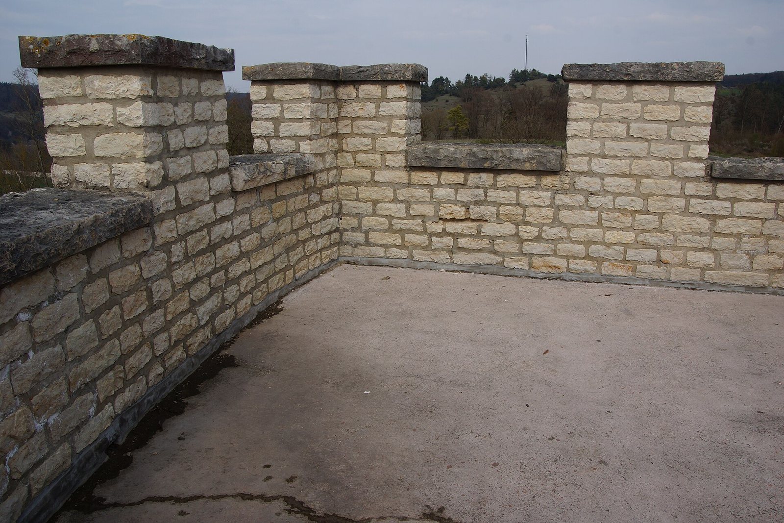
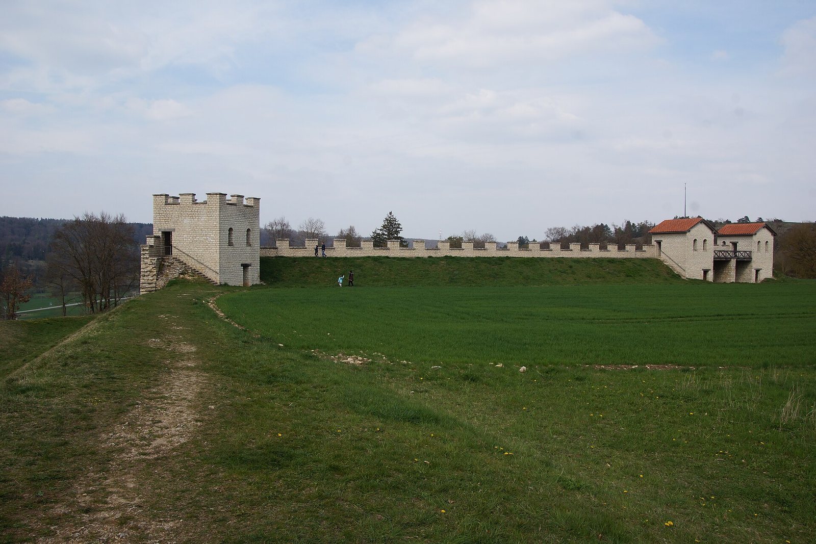
Roman military buildings at Pfünz had white plaster painted with red lines to imitate cut-stone blocks. The north gate, northwest tower, and connecting wall were reconstructed between 1992 and 1994 without specialist archaeological preparation. That work incorporated features from other forts and elements unsupported by evidence at Pfünz. The reconstructed gate and tower are one storey lower than the ancient buildings are thought to have been, and the tower has a roof for which the earlier excavation found no evidence. The result is a free interpretation rather than a reliable reconstruction of the original structures.
Buildings inside the fort
Headquarters
The headquarters stood near the fort’s centre, where its foundations now appear as slight rises in the ground. Its rooms, including a prison and an armoury, surrounded a slightly skewed rectangular courtyard. Heated rooms occupied the building’s northwest and southwest corners, and a shrine held the unit’s military standards. Two similar rectangular features detected within the courtyard by geomagnetic survey are interpreted as later than the Roman fort.
Bronze finds from the headquarters include a toe fragment that may have belonged to an imperial statue in armour, dated to the first half of the third century, and fragments of parade armour from burned debris. A prisoner’s leg bone, still caught in an iron chain and ring, was also found at the building.
Barracks and storage buildings
A large stone barrack for two groups of soldiers stood between the southwest corner tower and the south gate; its foundations were traced for about 40 m. Other accommodation for mounted troops used plastered timber framing. Two further double barracks stood beside the main north–south road near the north side, with two ordinary barracks between them and the headquarters. Another timber double barrack occupied the rear half of the fort across the east–west road from the stone barrack. The front blocks of the barracks, used by centurions and possibly other officers and staff, faced the main roads.
Two granaries stood west of the headquarters, and another was located outside the north gate, west of the road. The outside building measured about 37 m by 14 m. A separate stone building south of the two granaries measured about 20 m by 30 m and had substantial projections along its eastern wall. A large cistern lay south of the headquarters’ northeast corner. Its unusual magnetic signal has been attributed to strongly magnetic burned debris.
An iron fitting found in a granary excavated across an area measuring 9 m by 23 m was once considered part of a Roman surveying instrument. It is now interpreted as part of a grain measure, probably a wooden vessel of about eight litres. An iron rod passed through the base, and a pivoting cross could level grain with the vessel’s rim.
Civilian settlement and religious buildings
Houses and burial places
The civilian settlement extended about 400 m south from the fort’s south gate. Excavations identified 137 features, mostly masonry remains of long houses, cellars, pits, and cisterns arranged along the road. Opposite the circular temple at the settlement’s southern end, a cremation cemetery extended for about 70 m beside the road. Farther south, two groups of burial mounds comprised seven small mounds in total.
Temples and the Jupiter Dolichenus sanctuary
A circular temple at the settlement’s southern end had three niches for cult images. A smaller temple southeast of the cremation cemetery had a porch and an inner shrine. The sanctuary of Jupiter Dolichenus stood about 50 m outside the south gate. Its nearly rectangular enclosure measured approximately 21.1 to 21.45 m by 18 to 18.2 m. The boundary walls, about 0.9 m thick, survive between 0.2 and 0.5 m high.
Inside the enclosure, the nearly square shrine measured 4.8 m on each side and opened eastward. It stood close to the enclosure’s western wall, with a room interpreted as a sacristy to its north. A rectangular pit beside the shrine was 1.7 m deep and may have served as a cellar or cistern. Stone bases within the enclosure supported dedication stones, and another cistern, 3.5 m deep, lay outside it.
Two bronze plaques dedicated to Jupiter Dolichenus were found in the sanctuary; one bears a priest’s name read as Demittius. A fragment of another plaque has an illegible inscription. Nearby, a cache beside a pottery vessel covered by a slate slab contained two bracelets, an unmounted carnelian, a ring set with carnelian, and 95 silver coins. The coins range from an issue of Faustina the Younger to six of Julia Mamaea, with the latest dated to AD 232. Apart from the Faustina coin, they belong to the Severan period; the cache includes issues of Septimius Severus, Elagabalus, and Severus Alexander. Human remains were also recovered from the sanctuary debris.
Two bronze figures of Victory, coated with tin and measuring 0.89 m and 0.78 m high, were recovered in the sanctuary area, one in front of the shrine and one near the entrance. Each held a wreath and palm branch and had originally stood atop a triangular dedication monument. A further figure, found in the temple area in 1997, shows Victory on a globe with a palm branch.
Workshops and facilities in the valley
Craft district
The craft district lay east of the fort, on the valley floor between the Pfünzer Bach and the steep slope to the fort plateau. Excavations identified three pottery kilns, furnaces for iron smelting and smithing, building remains, cisterns, wells, and refuse pits. The nearby stream provided water for the workshops.
Bath building
The fort bath lay below the east gate, north of the iron-working area. Its substantial foundations included a floor of high-quality Solnhofen limestone slabs. The bathing rooms were arranged in sequence, and the building’s long side ran north. A winding path connected the bath with the fort. Geomagnetic survey found features between the bath and the slope that may be buildings buried under later soil and rock debris.
Possible roadside inn
The large building tentatively identified as a roadside inn lies south of the bath. It measures about 40 m by 34 m, with its long side running north. Its central open court narrows and opens toward the south. A corridor about 2 m wide runs along its west, east, and north sides, adjoining at least 16 rectangular groups of rooms.
Reused stone and other finds
Former church
St. Nicholas’s former parish church stood about 50 m northeast of the fort’s northeast corner. Its foundations incorporated large limestone and tuff blocks and fragments of carved coping from Roman buildings. A damaged altar dedicated to Sedatus was also recovered from the church.
Military equipment and tableware
Other finds from the fort include a third-century bronze armour fitting with partly uncertain inscriptions naming a unit and owner, fragments of parade armour, a short neck guard decorated with acanthus scrolls from a mask helmet, and a decorated left breast fastening plate found in the northwest corner tower. The fastening plate is dated to the first third of the third century.
By the beginning of the 1960s, 337 fragments of fine Roman tableware had been recorded from the fort, settlement, and cemetery. Maker’s stamps include Primitivus, Julius II–Julianus I, Victor I, and the early maker Ianu I; one stamped vessel is of form Dragendorff 37. Four vessels attributed to Victor I or an imitator have been treated as the latest fine wares from Pfünz, supporting the possibility that the fort was destroyed or abandoned after AD 240. Other potters’ wares may have continued to be made after the fort’s destruction.