Teppe Hasanlu: An Ancient Settlement and Citadel in Iran
Site at a Glance
- Popularity
- High
- Country
- Iran
- Primary era
- Iron Age
- Eras represented
- Bronze Age, Iron Age, Classical
- Civilizations
- Achaemenid, Urartian
- Site type
- City
On this page25 sections
History
Teppe Hasanlu is an ancient settlement mound near the village of Hasanlu in West Azerbaijan Province, Iran. Its communities occupied the site from the sixth millennium BC into the third century AD, and its most influential phase was the flourishing of Period IV, broadly dated from the thirteenth to the ninth centuries BC. The people who built and lived at Hasanlu have not been identified with certainty.
Early occupation and Period IV
Excavators divided Hasanlu’s long sequence into ten periods, numbered from X, the earliest, to I, the latest. Period X dates to about 6000 BC, while Period VII is placed around 3000 to 2500 BC. Hasanlu VIa, a phase dated to around 1600 to 1450 BC, preceded Period V, which may date to about 1300 BC. Polished, unpainted pottery known as Monochrome Burnished Ware became prominent in Period V.
Period IV was the settlement’s principal period of growth. Its major stone buildings belong to this phase, although stone also appeared in some Period V foundations. Around 1250 BC, changes in material culture mark the start of a phase conventionally called Iron I, an archaeological period label rather than a claim about universal iron use. In a revised chronological scheme, this phase is identified with Hasanlu IVc rather than Period V.
Destruction and rebuilding
At the end of IVc, around 800 BC, fire and violent destruction abruptly ended the settlement’s flourishing phase. Radiocarbon dating places the event at about this time. An Urartian attack is a likely explanation, although the attribution remains uncertain. Urartu was a kingdom centred near Lake Van; Assyria, another regional power, also had cultural and political influence in the area.
The citadel and Lower Town were quickly rebuilt. The new Iron II buildings followed earlier plans but were larger and more elaborate. These changes took place as Urartu extended its influence south of Lake Urmia and Hasanlu interacted with Assyria. Finds from the settlement have also been interpreted as consistent with the possibility that it retained political independence.
Later occupation
Occupation continued through periods associated with the Medes and Achaemenid Empire in Period III. Period II spans Achaemenid, Seleucid, Parthian and at least part of the Sasanian rule. A house in Level II dates to the fourth century BC. Period I represents a thin late-Sasanian and early Islamic phase, while a separate settlement of the fourteenth century AD was also identified at the site.
People and regional connections
Hasanlu is often associated with the Mannaeans, an ancient people and polity of the region south of Lake Urmia. The identities and language of the Bronze and Iron Age inhabitants remain debated. Archaeological comparisons have connected Hasanlu with Kassite, Hurrian, Urartian and Median cultural spheres, and an Armenian connection has also been proposed. Such comparisons do not establish a single identity for the settlement’s population.
A 2022 genetic study examined individuals who lived at Hasanlu around 1000 BC. It found some ancestry related to Eastern European hunter-gatherers, at a lower level than in contemporary Armenian samples, and patrilineal affinity with ancient Armenian populations. The researchers considered the results compatible with either an Armenian-related language or a local non-Indo-European language; the genetic evidence does not settle the question of what Hasanlu’s inhabitants spoke.
About fourteen other ancient mounds lie within roughly two to fifteen kilometres of Hasanlu. Their distribution has been interpreted as evidence for neighbouring communities and contact, including trade, with Hasanlu, within a flourishing regional population.
Excavation and heritage
Investigations included Iranian commercial excavations and scientific work led by Ali Hakemi and Mahmoud Rad. Aurel Stein carried out archaeological soundings at Hasanlu in 1936, and the Iranian Archaeological Service excavated there in 1947 and 1949. Many objects recovered during the Iranian investigations were taken to Tehran and are now held at the Museum of Ancient Iran.
An Iranian-American expedition directed by Robert H. Dyson Jr. worked at Hasanlu for ten seasons between 1956 and 1974. It initially aimed to reconstruct the region’s cultural history from the Neolithic period to Alexander the Great’s conquest of the Achaemenid Persian Empire. The discovery of the gold bowl in 1958 shifted the project’s emphasis toward Hasanlu’s Iron Age levels, while work at other regional sites continued. The Hasanlu Publications Project began in 2007 to prepare final excavation monographs; two excavation reports and several specialist volumes have since been completed. Hasanlu entered Iran’s National Heritage List in 1965 under the name Tappeh Hasanlu.
Remains
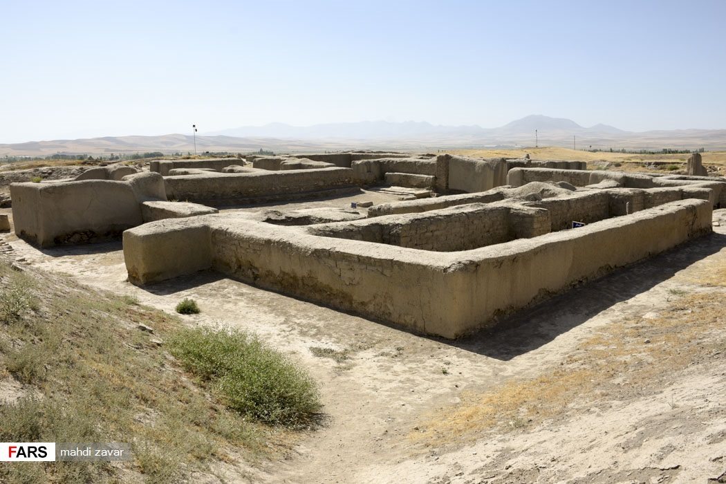
Hasanlu occupies a prominent position in the Gadar River valley, overlooking the Solduz plain between the villages of Hasanlu and Aminlu, about seven kilometres from Naqadeh and twelve kilometres southwest of Lake Urmia. The settlement’s archaeological area has been reduced by farming and construction. It now extends about 600 metres across. A central high mound, or citadel, rises about 20 to 25 metres above the plain and is roughly 200 metres in diameter; the broader mound measures about 250 to 285 metres across. The surrounding Lower Town stands about eight metres above the plain. Buildings of mudbrick, clay and stone, paved streets and substantial fortifications formed the settlement’s principal elements.
Citadel walls and entrances
Citadel fortifications
A defensive wall enclosed the high mound. It measured about three metres thick and seven metres high, with square towers about ten metres on each side at intervals of roughly thirty metres. The towers projected both outward from the wall and into the citadel; about seven tower positions have been identified. The line of the fortifications changed between Periods III and IV. After fire brought down sections of the wall and damaged towers, rebuilding shifted the wall’s alignment slightly.
Entrances and internal routes
A defensive entrance on the western side opened onto a route into the citadel. An internal gateway and large residential buildings have also been identified on the high mound. A fortified approach on the southwest side has been proposed as another entrance, although interpretations of those remains differ.
Central courtyard and columned halls
Central courtyard
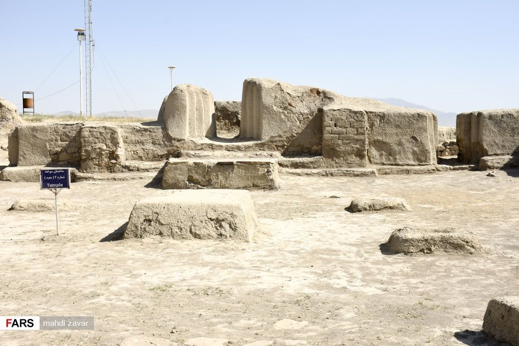
The central courtyard was an irregular polygon about twenty-nine metres long and nineteen metres wide, reaching a width of about twenty-one metres at its northern end. A probable altar stood at the south end. Tall stone uprights, at least three metres high and set several metres apart, were fixed to the north wall. Flat-paved stone platforms along the north and west sides stood about sixty to seventy centimetres high and measured roughly 1.2 to 2.3 metres across. Small and large rooms, columned halls and long porches surrounded the open space, and remains of these features survive in their original positions.
Eastern columned hall
The eastern hall was the first of three major columned buildings. Its excavated portion measures sixteen by four metres. Four columns stood in two rows, about five metres apart, and stone bases beside the walls supported additional wooden columns. A southern area appears to have served as an altar or priest’s space. Two horse skeletons were found about five metres apart in the hall. After the southern hall was built, the eastern building appears to have been reused for keeping horses.
Southern columned hall
The second and largest hall stood within an architectural complex south of the courtyard. It measured about 24.3 by 18.5 metres and had eight central columns, with further columns around its perimeter and walls. Wooden roof supports rested on stone bases. The single-storey hall stood about seven metres high, while surrounding buildings had two storeys of about 3.5 metres each; their roofs met at the same level.
Near the northern entrance, a mudbrick platform about two by three metres may have served ceremonies. A feature at the middle of the south side, joined to a small room behind it, may have been an altar or priest’s station. Burning was concentrated around two fire installations, one near the northeast side and another in the southwest corner. Doors on the north and west sides measured about two metres wide; those on the south and east were about 1.2 metres wide. Two paved platforms flanking the north entrance each measured about eight by 2.5 metres. They may have accommodated invited participants or an audience. Two small porches stood outside the entrance, near a large stone measuring about four by two metres that may have served as an altar.
Western columned hall
The last of the three halls stood northwest of, and some distance from, the southern hall. Its plan measured about 15.6 by fifteen metres, with stone columns and entrance doors about two metres wide. The building lay about 3.9 metres from the defensive wall. A fire installation occupied its northeast side, and a central feature may have been a ceremonial or priestly area.
Residential and working areas
Southern rooms and storerooms
A large hall and several storerooms occupied the southeast side of the courtyard. Many large jars stood in the hall, which connected by a doorway to another storeroom containing jars. Their intended contents are uncertain. They may have held water or wine, with water storage considered plausible given the citadel’s military character and the prospect of a siege.
Rooms south of the courtyard included storerooms, a kitchen and an armoury or weapons workshop, most connected to the large southern hall. A broad corridor behind the hall may have served as a weapons store or manufacturing area; iron swords and spearheads were recovered there. An entrance at the southeast corner of the courtyard gave access to this group of rooms. Interconnected spaces west of the hall linked it with the western buildings and the third columned hall.
Western complex
The western architectural complex contained more than fifteen connected rooms. It lay between the courtyard to the east and the citadel’s western wall, with a narrow corridor to its south and a route along its northern side. A large entrance on the north led down a staircase about nine to eleven metres long into a passage measuring twenty-two by nine metres. Gates at the passage’s west and east ends were about 16.5 metres apart, and a south doorway opened onto a narrow corridor. A hall to the west measured 14.6 by 30.4 metres and connected through a two-metre-wide doorway to the western columned hall.
Excavated buildings on this side include Burned Building III, a large residence, and Burned Building VII, which may have been an arsenal and controlled access to the citadel. Burned Building I and Building I East formed a fortified entrance into the Lower Court; Building I also served as an elite residence. Buildings II, IV, IV East and V were arranged around a stone-paved court. Building II is interpreted as a possible temple.
Northern courtyard rooms
Fifteen rooms were identified in buildings north of the central courtyard. Their use is uncertain, although they may have housed women of the citadel and perhaps servants or enslaved people. Small box-shaped containers for cosmetics, including bone and ivory containers for kohl, were found in this area.
Eastern courtyard complex
A large hall excavated in trenches Y31 and Y32 had small and large connected rooms to its north, entered from the northeast side of the central courtyard. Finds from this complex included a bronze handle decorated with Gilgamesh, the legendary king at the centre of an ancient Mesopotamian epic, and a lion-like animal. Excavators also recovered burned fabric, two cylinders bearing goat designs, bronze tools and a horse bit.
Artisan’s House
The Lower Town was occupied as well as the high mound. A house excavated in 1957 and 1959 is called the Artisan’s House because evidence of copper and bronze working, especially casting, was found there.
Destruction deposits and finds
Human and animal remains
More than 285 people were found among the destruction remains. Burned Building II contained more than seventy women and children who had been killed violently, alongside only a few adult men. Human remains, horses and cattle were also found burned. In trench W3E, roof timbers had become charcoal amid thick ash and other evidence of intense fire.
Trench W29 contained the disordered remains of eleven people, including four children. Several skeletons were incomplete or decapitated, and their positions were interpreted as consistent with violent deaths rather than formal burial. In an adjacent room, two people had fallen together while apparently lying down. Numerous burned skeletons also lay in the central courtyard. In trench W30, excavators found two finely carved, three-legged stone plates, and two large stone slabs stood on a platform beside a doorway. A person lay face-down at the bottom of a well.
Trenches W18 and W19 contained walls from three occupation phases, a cow skeleton and three human skeletons. An iron spearhead had entered the cow’s abdomen, and an iron arrowhead lay above its head. The circumstances linking these remains with the fire are uncertain.
Gold bowl and associated objects
The gold bowl was found in 1958 in a small room north of the passage leading to the western columned hall. It lay beside a fallen person who had been stabbed in the back; the dagger had also pierced the bowl. The Iron Age vessel is held at the Museum of Ancient Iran. Its varied designs have been considered artistically important and may draw on two ancient stories, one about a hero in a chariot punishing oath-breakers and another about Fereydun’s victory over Zahhak with Kaveh’s help. In Iranian legend, Kaveh assists Fereydun in defeating Zahhak and freeing Fereydun’s sisters. A silver cup was also recovered during the expedition’s work at Hasanlu.
Other finds and excavated layers
Rooms in the eastern hall and nearby buildings contained several skeletons, including a woman and man found in an embrace. In the central mound, a deep test pit reached natural ground and water 17.5 metres below the original surface. Trench U22 placed the top of Period IV about ninety centimetres below that surface. The Period IV deposit was 140 centimetres thick, Period V measured 200 centimetres, and Period VI measured 190 centimetres. Period VII began below the original floor of Period VI; its upper boundary lay 20.6 metres below the mound’s present surface.