Nyenschantz: A Swedish Fortress on the Neva Delta
Site at a Glance
- Popularity
- Very High
- Country
- Russia
- Primary era
- Early Modern
- Eras represented
- Medieval, Early Modern, Modern
- Civilizations
- Swedish
- Site type
- Military
- Remains
- Fort
On this page16 sections
History
Nyenschantz was a Swedish fortress built in 1611 at the confluence of the Okhta and Neva in present-day St Petersburg, Russia. Its timber-and-earth star-shaped defenses were intended to secure the Neva mouth and assert Swedish authority in Ingria, the contested region around the eastern Gulf of Finland and the Neva. The fortress stood beside Nyen, a trading town, and later became a focal point in the Swedish-Russian struggle for control of the Baltic region.
Early settlements and medieval forts
Communities occupied the nearby coast and Neva banks from the fifth millennium BCE into the middle of the first millennium CE. A watch post may have stood here in the twelfth century. In 1300, the Swedes built the fortress of Landskrona. Russian forces led by Prince Andrey of Gorodets captured and burned it the following year. Excavations have revealed traces of three medieval fortifications in the area, though Landskrona is the only one identified by name in historical records.
A Russian settlement known as Nevsky Gorodok or Nevskoye Ustye developed here during the fifteenth and sixteenth centuries. A record from 1500 describes three villages and a hamlet of 18 households at the Okhta mouth. In 1557, work began on a port-fortress near the Neva mouth under the direction of Ivan Vyrodkov and P. Petrov. Records from 1599 to 1601 refer to a state trading yard, a landing place for ships, an Orthodox church and local residents. In 1615, 16 ships arrived from settlements including Novgorod, Vyborg, Narva, Stockholm and Norrköping.
Swedish rule and the growth of Nyen
Swedish troops established Nyenschantz in 1611 on territory taken from Russia. Sweden justified the move by claiming that Russia had failed to honor the 1609 Treaty of Viborg, under which Sweden had promised military assistance to Tsar Vasily IV in return for Korela Fortress and its district. Commander Evert Horn founded the new stronghold to control the Neva mouth and extend Swedish authority in Ingria. Its garrison could reach about 500 soldiers. The Swedish name Nyenskans means Neva fortification.
The 1617 Treaty of Stolbovo placed Ingria under Swedish rule. A trading town called Nyen, also known as Nyenstadt, grew on the opposite bank of the Okhta. King Gustav II Adolf granted it town status in 1632, and Queen Christina gave it full urban rights during the following decade. By 1642 it served as the administrative centre of Swedish Ingria. In the mid-seventeenth century, more than 400 households paid taxes there, and the town had about 2,000 residents, making it the largest settlement in Nöteborg county.
Finns, Swedes, Germans and Russians lived in Nyen, earning their livelihoods through trade, crafts, farming, fishing and navigation. Swedish and Finnish Lutheran congregations had separate churches and occupied different parts of town. Orthodox residents worshipped across the Neva at Spasskoye. A German Lutheran church may have been established in the 1640s or after 1656, and disagreements between its clergy and Swedish Lutheran authorities continued into the late seventeenth century. In the early 1680s, regional church official Johann Geselius the Younger temporarily closed the Spasskoye church and barred Orthodox residents, including Izhorians, Karelians and Russians, from settling in Nyen.
Destruction, rebuilding and expanded defenses
In 1656, Russian forces under Pyotr Ivanovich Potemkin stormed Nyenschantz. The attack apparently killed nearly all of Nyen’s residents; those who escaped into the forest survived. After the conflict, Sweden retained the fortress and surrounding territory. The fort was rebuilt to a revised design by military engineer Heinrich von Soylenberg, under the oversight of Ingrian Governor-General Simon Grundel Helmfeldt.
Plans to strengthen the defenses had been drawn up in the 1640s and early 1650s, but a proposed scheme approved in 1652 went unrealized for lack of funds. Further proposals from 1671 called for southern defenses and town expansion. The plans were revised in 1675, and a map from 1681 shows construction underway. In 1677, new fortifications were built around Nyen between the Neva and the Okhta.
The siege of 1703 and the end of the fortress
The Great Northern War, a conflict between Sweden, Russia and their allies over control of the Baltic region, brought the fortress back into battle. After Russian forces captured Nöteborg in October 1702, Swedish troops under Major General Abraham Croniort prepared Nyenschantz for an assault. Commandant Johan Apolloff ordered Nyen burned and its residents evacuated to Vyborg, denying the Russians the town’s buildings during a siege. Swedish troops also prepared earthworks south of the fortress and across the Neva near Spasskoye.
The Russian siege lasted from 25 April to 1 May 1703. A force of about 20,000, commanded by Peter I and Field Marshal Boris Sheremetev, faced a garrison of 700 with 78 guns. Russian troops seized defensive positions at Spasskoye and south of the fortress, occupied Nyen, and advanced to the ditch and southern bastions. Apolloff rejected a demand to surrender. After 14 hours of artillery fire, the powder magazine exploded and the garrison capitulated.
Swedish troops under G. Meydel occupied the abandoned fortress twice in 1704 and 1705 but withdrew without securing it. Peter I renamed it Schlotburg, but a military council judged the position too small, too far from the sea and too poorly protected by its natural surroundings. Russia had already begun a new stronghold on Hare Island in May 1703, the Peter and Paul Fortress; Kronshlot followed the next year. Saint Petersburg subsequently grew across the surrounding Neva delta.
Later use and archaeological investigation
Peter I ordered the removal of Nyenschantz’s above-ground defenses, but the timing and extent of demolition remain uncertain. Work may have begun as early as 1704, while maps and records indicate that portions of the fortress and its outer defenses remained for decades. After Nyen lost its town status, new settlements for people transferred to the capital occupied parts of its former suburbs by 1725. A plant nursery and greenhouse operated on the fortress site during the 1740s to 1760s. The land later passed to the Smolny Institute and then to the Naval Department, which established a shipyard there in the 1790s.
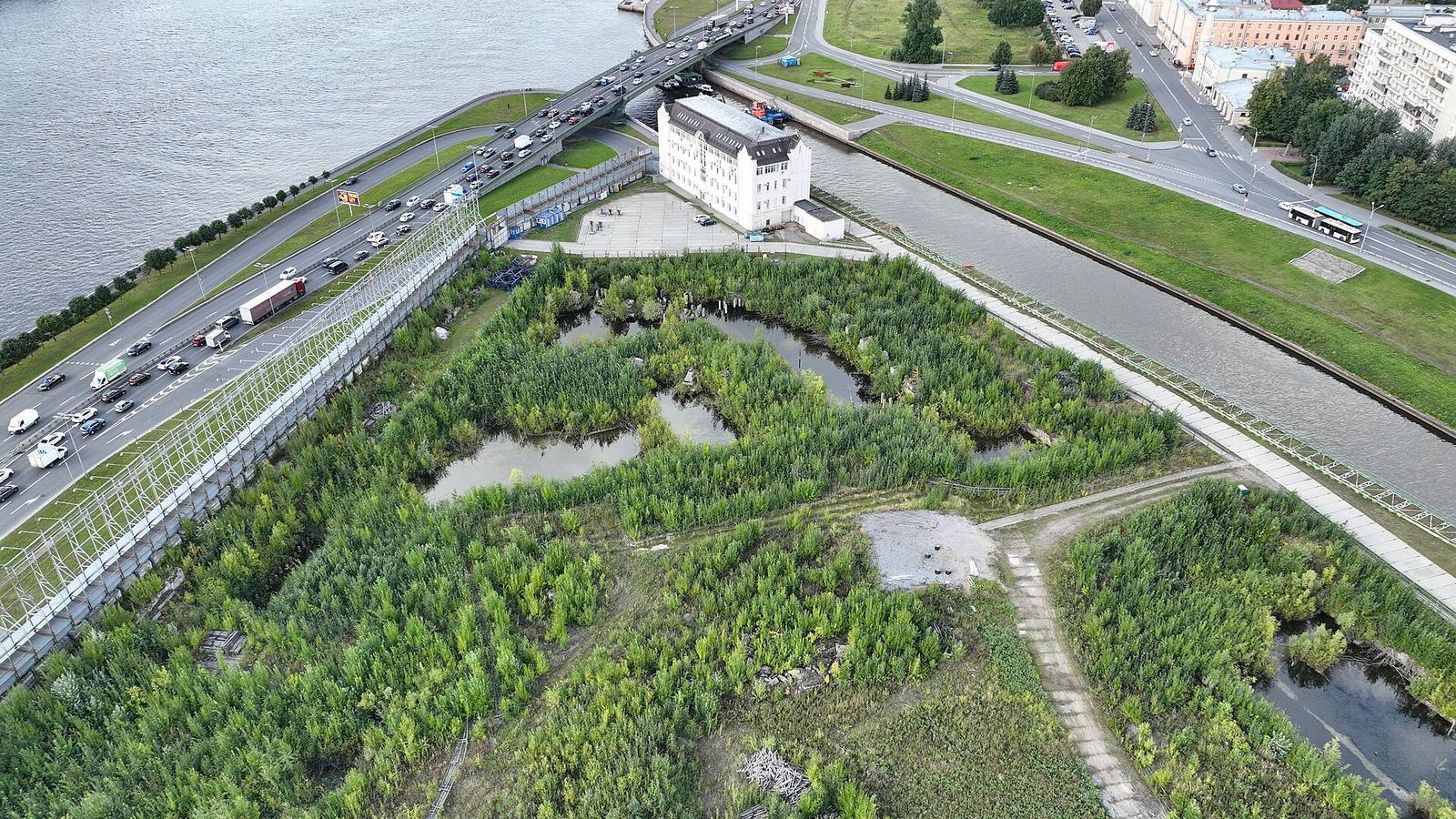
The Okhta shipyard operated from 1808 to 1914 and was followed by the Petrozavod works, which remained active into the 1990s. The area became part of Saint Petersburg in 1828. Archaeological investigations began in 1992 under Pavel Sorokin and continued through 1998, revealing remains of medieval fortifications. Research from 2006 to 2010 examined 4.4 hectares of the former Petrozavod site, with more than 40,000 square metres excavated in total. Several archaeological areas covering 2.4 hectares were identified. A proposed skyscraper project was abandoned in 2010. The site received state protection as an archaeological monument in 2001 and also holds federal cultural-heritage status; in 2009, the protected boundary was reduced and no longer included the central area. Further excavation near the Okhtinskaya Hotel began in 2023 in connection with plans for the square in front of it.
Remains
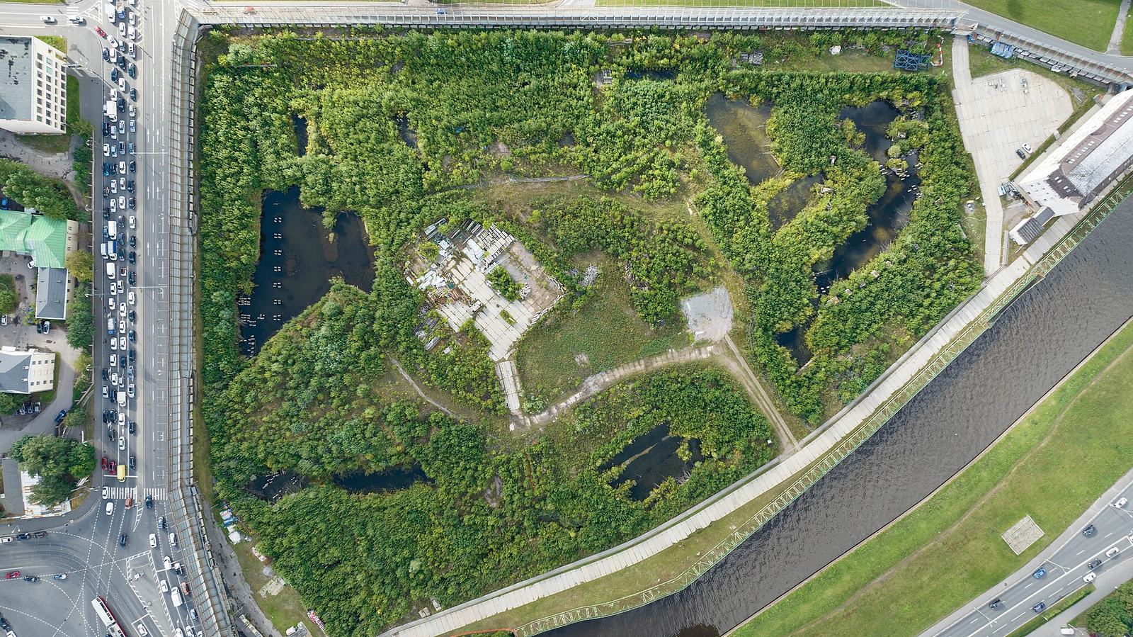
The fortress occupied Okhta Cape, where the Okhta meets the Neva. It stood on the Okhta’s left bank opposite Nyen, on the right bank, and combined a timber-and-earth star-shaped core with defensive works extending beyond it. Excavations have exposed parts of its bastions, connecting walls and ditch, as well as features from the neighboring town.
The fortress
Plan and defensive works
A map from 1643 depicts the earlier fortification as a simple rectangle with several houses. The rebuilt stronghold took the form of a five-bastion star fort made of timber and earth. Its bastions, projecting sections of a fortification, were linked by curtain walls, the stretches of wall between them. Two ravelins, outer defenses set in front of the main works, added protection. The main gate faced the Okhta, and a bridge connected the fortress with Nyen.
The five bastions were named the Mill, Old, Dead, Karl’s and Helmfeldt’s. The Old Bastion occupied the site of Landskrona, while the Dead Bastion stood where a riverside cemetery had been. The Mill Bastion was nearest the Neva, and the Dead Bastion nearest the Okhta. A small-gate ravelin protected the northern tip of the cape, with a large-gate ravelin to the south. A plan from 1681 gives the fortress a diameter of about 245 metres. Its bastions were up to 60 metres wide, its curtain walls about 50 metres long, its ramparts about 19 metres wide and its ditch about 28 metres across.
Defenses also extended south of the main fort in a three-bastion crownwork, an outer defense with a central section and projecting wings. Two lunettes, smaller detached defensive works, lay farther south, and another stood on the Okhta’s right bank. Plans proposed a smaller fortification on the opposite bank of the Neva. By the late seventeenth century, the fortress could hold about 600 people and was equipped with roughly 80 guns.
Excavated defensive remains
Excavations exposed parts of the Helmfeldt, Karl, Dead and Old bastions, together with sections of their connecting curtain walls. These remains survive at different locations to heights of about 2.5 to 4 metres. The defensive ditch reaches a depth of about 4 metres and traces the former positions of the bastions and curtain walls. It was partly filled during the eighteenth century, with most of its infilling taking place in the nineteenth century during construction of the Okhta Admiralty shipyard. A fragment of Karl’s Bastion was conserved in 2011. Other excavated features include a well lining and a structure with a cobbled floor.
The town of Nyen
Streets and civic buildings
Nyen’s market square and town hall stood on the right bank of the Black Creek, or Chernavka, where it met the Okhta. Farther upstream on the same bank were a Lutheran church and a school. The town’s central buildings included two Lutheran churches, a harbor, a marketplace and old and new municipal buildings. Streets and houses followed the Okhta and Black Creek, as well as roads leading toward Vyborg, Kexholm and Nöteborg. A hospital, brickworks and businesses connected with shipbuilding stood beyond the main town.
Houses and excavated streets
Most buildings were timber, while stone and brick were used for foundations, stoves and paving. Excavations along Kontorskaya Street between 1999 and 2008 covered about 900 square metres. They revealed log-built and timber-frame houses, alongside structures sunk as much as 1.5 metres into the ground, with lower semi-basement levels. Near the former German church, foundations made from roughly dressed limestone slabs had been leveled locally with brickwork.
In another part of the former settlement, excavations revealed four wooden buildings at depths of about 1.2 to 1.6 metres, along with adjoining yard surfaces and a paved street. Burnt beams, charcoal and soil altered by heat show that fire destroyed the buildings. Copper coins found beneath their floors suggest that this destruction occurred in the early 1700s.
Finds and memorial
Archaeological objects
Excavations recovered objects made of bark, amber, clay, wood and stone from the Neolithic and Early Metal Age, a prehistoric period marked by the first use of metal. Other finds include household goods, Swedish coins and personal ornaments. These objects are held in storage following study.
Granite memorial
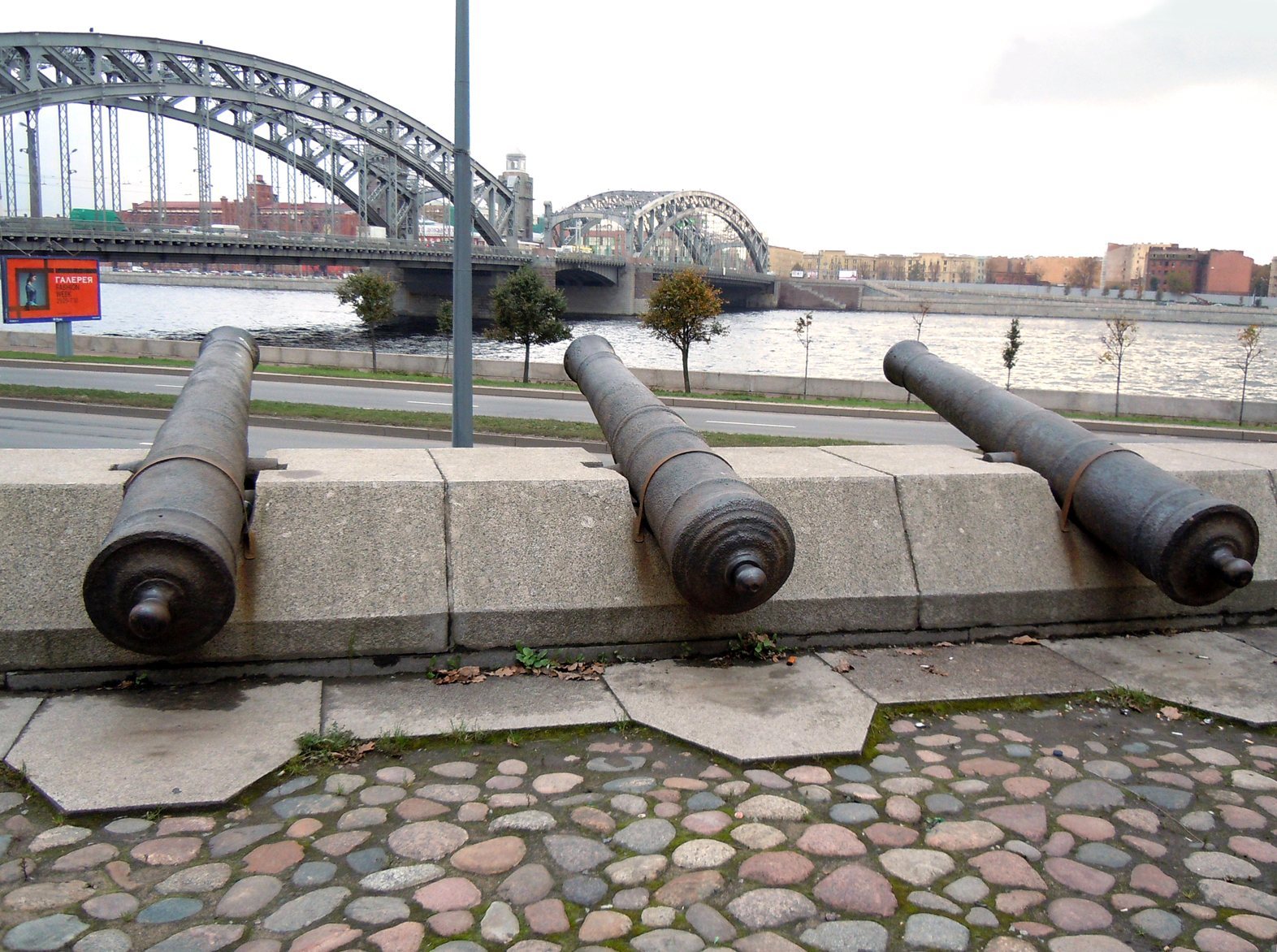
A granite memorial opened on 15 June 2000 on the former Mill Bastion. It incorporates cannons believed to have been found in the Okhta in 1903 and recovered in the 1990s. The guns had once been placed around an oak traditionally said to have been planted by Peter I. A bomb struck that tree in 1941; a replacement planted after the war was cut down during factory construction in the 1970s. After recovery, the cannons were first displayed at the factory entrance before becoming part of the memorial.