Al-Kahf Castle: A Medieval Nizari Ismaili Mountain Fortress in Syria


Site at a Glance
- Rating
- 4.4
- Popularity
- Very Low
- Country
- Syria
- Primary era
- Medieval
- Eras represented
- Medieval
- Civilizations
- Nizari Ismaili State
- Site type
- Military
- Remains
- Castle
On this page16 sections
History
Al-Kahf Castle is a medieval Nizari Ismaili mountain fortress in Syria, near al-Qadmus in the Al-Ansariyah mountains. Architectural evidence points to the early eleventh century, while the castle’s construction is generally dated to around 1120. Built as a fortified center in a mountainous region, it later became a major Nizari base and the headquarters of Abu Muhammad, the chief da’i of Syria. A da’i was a religious missionary and authority within the Ismaili tradition.
Early ownership and Crusader occupation
Saif al-Mulk ibn Amrun is associated with the foundation or early ownership of the castle. He was identified as its owner in 1101. Crusader forces occupied Al-Kahf in 1123, but its former owner recovered it in 1128. These changes occurred during a period when fortified sites in the Syrian mountains were contested by local rulers and Crusader forces.
After Saif al-Mulk ibn Amrun’s death, disagreements among his sons affected control of the fortress. In 1138, his son Musa sold Al-Kahf to the Nizaris, a branch of Ismaili Shiism that established fortified centers in the Middle East during the medieval period. The Nizaris developed the castle into an important base, and it became the headquarters of Abu Muhammad, the leading Nizari religious figure in Syria.
Rashid al-Din Sinan and the Mamluk conquest
By 1162, Al-Kahf was controlled by Rashid al-Din Sinan, the leader of the Syrian Ismailis. Under Sinan, the fortress was substantially strengthened and gained strategic importance in the region. He used it both as a base and as a place of retreat. Sinan is traditionally said to have died and been buried at Al-Kahf in 1193, although the attribution of a nearby mausoleum to him remains uncertain.
In 1197, Henry II, Count of Champagne and regent of Jerusalem, visited the castle while travelling between Acre and Antioch. His purpose was to seek an alliance with Sinan’s successor. The visit reflects the place that Al-Kahf held within the political and military landscape of medieval Syria.
Al-Kahf was the last Ismaili stronghold in Syria to surrender during the Mamluk expansion. The Mamluk Sultanate was the medieval state that ruled Egypt and Syria and extended its authority into former Nizari territories. Sultan Baibars imposed a heavy tax on the fortress in 1268, amounting to 150,000 dirhams, and captured it in 1273.
Ottoman use and destruction
The castle continued in use during the Ottoman period, when the Ottoman Empire ruled Syria from the sixteenth century until the early twentieth century. It was sometimes used as a prison for important prisoners. In 1816, Mustafa Agha Barbar, the Ottoman governor of Tripoli, ordered its destruction. The fortress is now owned or administered by Syria’s Directorate General of Antiquities and Museums. It survives in a partially ruined and poor condition.
Remains
Fortress layout and defenses
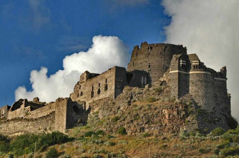
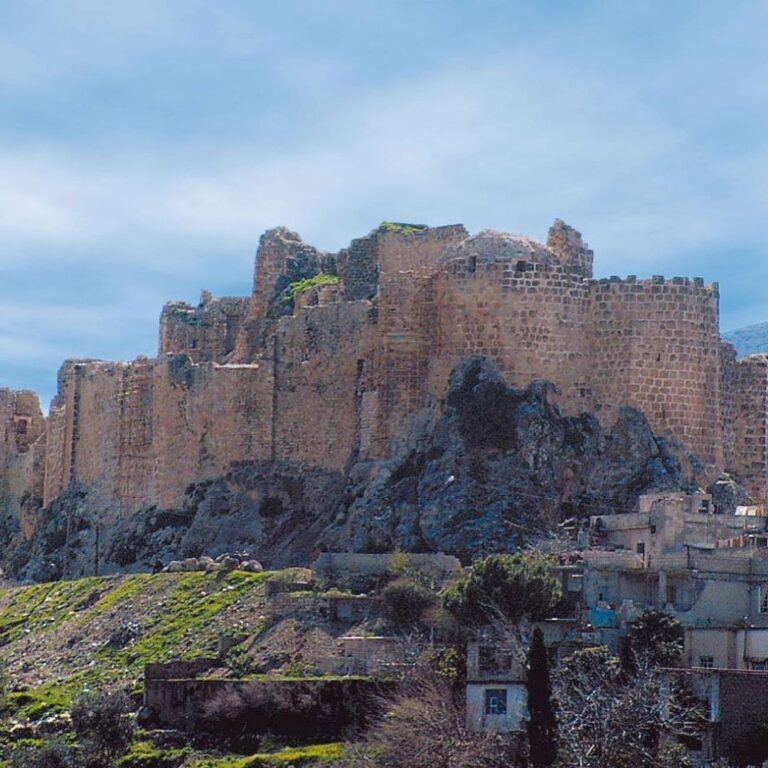
Al-Kahf occupies a rocky plateau and ridge within the coastal mountain range. Its main axis follows an east-west rocky spur, and the fortress extends for about 600 metres while exceeding 15 metres in width. Deep gorges surround the site, with three ravines described as part of its natural enclosure. The rock-cut construction gave the fortress the name “Castle of the Cave.” It was cut into the mountain using a method compared with Stone Age rock architecture, while later additions strengthened its defenses. Rock and limestone form the principal materials.
Towers, walls, and entrances
Three towers rise above the surrounding walls. The eastern tower projects in front of the castle and overlooks Qadmus Castle to the northeast. The northern tower stands above the main entrance and looks over a deep valley, while the southern tower overlooks another deep valley south of the fortress.
The western part of the site forms a flat area about 170 metres long. Its principal surviving features are the outer walls and a bastion, a projecting defensive structure. From this outer area, the ground rises toward the central citadel, the principal fortified core of the complex, and its inner defenses.
Entry followed a staged route across the rock. The first entrance lay on the western side, with its outer doorway facing north. From there, the route climbed gradually southward over the rock surface to a second gate beneath the northern tower. This gate led upward toward the west and a third entrance, most of which has collapsed or disappeared. Western and eastern gates are also recorded, although the eastern gate no longer survives.
Rock-cut gateway and northern approach
A large gateway cut into the rock stands beside the entrance on the western side of the castle surface. Its interior measures about 3 metres across and 6 metres in length. Inside is a feature resembling a stone trough or basin. Two raised platforms beside the gateway functioned as seats and may have been used as a waiting area or a room for guards.
The northern approach included a narrow path descending partway along the steep slope to an entrance cut into a cave. This entrance survives in an abandoned state. The route formed part of the fortress’s access system along the northern side of the rocky ridge.
Interior spaces and religious buildings
Chambers and living quarters
Seven chambers were carved into the rock inside the fortress. Their entrances are difficult to reach, and they were formerly lit through openings cut into the rock roof. Pillars left in the bedrock supported the roofs and helped carry their weight.
The northern section contained living quarters, storerooms, and an area for storing water. Seven cisterns survive there and are among the better-preserved elements of the fortress. Their position within the northern section formed part of the internal system that supplied the occupied areas.
Mosque and training yard
The mosque stood on the eastern side of the upper surface, near a training yard. Only limited remains survive. They include a roofed hall whose vaults have collapsed. A stairway descended toward the training yard, but most of it has collapsed and its routes are blocked. Tradition identifies this stairway as the passage leading down to the cave and connecting the fortress with the bath at the bottom of the valley.
Bath and water systems
Bath and heating room
The bath lies at the southeastern end of the castle and is one of its principal surviving archaeological features. It has an approximately rectangular plan and is entered through a gate on the eastern side. Inside, the building is divided into an outer section, a middle section, an inner section, and a heating room.
The heating room has an opening on its northern side for releasing smoke and an adjoining room for storing fuel. West of the bath, a water tank was carved into the rock to a depth of more than 1.5 metres. The tank formed part of the water arrangements serving the bath and the wider fortress.
Channels, springs, and cisterns
Water reached the bath and castle through a channel system extending for roughly 2 kilometres from the spring of Ayn Aziza, now called Fatima Spring. Semicircular pottery channels carried the water above ground on supporting walls. The supply reached the bath first and was then distributed to the fortress.
A separate system gathered rainwater from the rocky surface of the castle. Channels directed runoff to collection points and vertical tanks, including the bath tank and the fortress reservoirs. These stores supplied the chambers and other sections of the complex.
Nearby mausoleum
Possible burial place of Sinan
A mausoleum stands approximately 500 metres northeast of the fortress. It is traditionally identified as the possible burial place of Rashid al-Din Sinan, but that identification remains uncertain.