Lepenski Vir: A Mesolithic and Neolithic Settlement in Serbia
Site at a Glance
- Rating
- 4.8
- Popularity
- Medium
- Country
- Serbia
- Primary era
- Stone Age
- External website
- Open
- Eras represented
- Stone Age
- Civilizations
- Unclassified
- Site type
- Domestic
- Remains
- House
On this page19 sections
History
Lepenski Vir is a major Mesolithic and Neolithic archaeological site in Serbia, near Donji Milanovac and the village of Boljetin, on the right bank of the Danube in the Iron Gates gorge. Its settlement was created and occupied by prehistoric communities between about 9500 and 4500 BC, and it gave its name to the Lepenski Vir culture. The site preserves a long sequence of occupation, including the transition from hunter-gatherer lifeways to farming and animal husbandry.
Early settlement and the Lepenski Vir sequence
Human habitation in the surrounding region reaches back to about 20,000 BC, as shown by nearby caves. Settlement on the low riverbank plateau began during the warmer conditions of approximately 9500 to 7200 BC, although the precise beginning of the Lepenski Vir culture remains debated. The archaeological sequence is divided into Proto-Lepenski Vir, Lepenski Vir I with phases Ia to Ie, Lepenski Vir II, and Lepenski Vir III. Its principal cultural sequence represents roughly 1,500 to 2,000 years of occupation, while broader estimates allow for as much as 5,000 years of intermittent or continuous use of the same habitat.
Proto-Lepenski Vir was a small community of perhaps four or five families and fewer than 100 people. Fishing probably formed its economic base. The Danube offered migratory sturgeon and beluga that entered from the Black Sea to spawn in the gorge, together with catfish and carp. Fishing was especially intensive in autumn, and the capture of very large fish required collective work. People also hunted adult male deer and took wild boar, roe deer, chamois, aurochs, brown bear, beaver, marten, badger, and various birds.
Changing economy and population
Later communities developed a more complex semi-nomadic economy. They used temporary camps for hunting and gathering food or raw materials, while occupational specialization and social differentiation became more pronounced. The settlement’s restricted promontory provided limited food, resources, and living space, and increasing population pressure contributed to social change.
Lepenski Vir records a gradual movement toward Neolithic life, a period associated with farming, animal husbandry, and more permanent settlements. Early European Farmers began arriving from Asia Minor around 7500 BC or later, bringing cereal cultivation and the herding of sheep, cattle, and goats. At Lepenski Vir they mixed with local Iron Gates hunter-gatherers, prehistoric foraging populations of the Danube gorge. The transition appears to have developed through contact and admixture rather than an external invasion, although its precise mechanism remains uncertain.
Ancient DNA from individuals dated to about 6000 to 5700 BC includes both Early European Farmer and Western Hunter-Gatherer-related ancestry. Some individuals were migrants who had not grown up at the settlement. Mesolithic and Proto-Lepenski Vir individuals have been modeled as predominantly descended from local Iron Gates hunter-gatherers without Aegean ancestry, which appears in the cited analyses only after about 6200 BC. Reported paternal lineages include R1b1a, C1a2b, G2a2b2a1a1c, C2c, and I2, while reported maternal lineages include HV, H13, H40, J2b1, K1a1, H3v, U5, H, J, X, T, and N1a. These genetic lineages describe ancestry patterns rather than ancient ethnic or cultural identities.
During the late architectural phase, around 6300 to 6000 BC, the settlement developed distinctive trapezoidal buildings and monumental stone sculpture. Farming and herding expanded, including the keeping of sheep, cattle, goats, and pigs. The dog may have been domesticated locally at an earlier Mesolithic stage. The youngest phase belonged to the Starčevo culture, a Neolithic archaeological culture of the Balkans. Occupation ended around 4500 BC, when inhabitants sought larger areas of cultivable land. The later Neolithic sequence was followed by the Vinča culture and the Starčevo culture, whose centers lay upstream along the Danube, about 135 km and 139 km from Lepenski Vir respectively. Related settlements included Hajdučka Vodenica, Padina, Vlasac, Ikaona, and Kladovska Skela.
Discovery, excavation, and relocation
Lepenski Vir was discovered on 30 August 1960 during a regional archaeological project organized by the Belgrade Institute of Archaeology. Obrad Kujović and Ivica Kostić surveyed land owned by the local farmer Manojlo Milošević because the planned Iron Gate I Hydroelectric Power Station and its reservoir threatened to flood the Danube bank. Kujović found large quantities of pottery fragments, identified them as belonging to the Starčevo culture, and reported them to the institute. Dragoslav Srejović contacted him in 1961 and later became the principal investigator. The discovery is now chiefly associated with Srejović, although Kujović’s role led to a later dispute over recognition of the original find.
Srejović and Zagorka Letica began investigation on 6 August 1965. Initial probing developed into protective excavation in 1966 and systematic excavation in 1967, continuing through 1970 or 1971. The first Mesolithic sculptures appeared in 1967, and the importance of the site was publicly announced on 16 August that year. A necropolis was found in 1968. Excavation reached about 3.5 m below the surface, beneath a humus layer roughly 50 cm thick, and exposed seven successive settlements with approximately 136 to 138 residential, sacred, and other structures.
The Iron Gate I Hydroelectric Power Station became operational between 1970 and 1972, forming the artificial Đerdap Lake. To protect the excavated settlement from inundation, most of it, including nearly all Vir I houses, was relocated in 1971 to a position about 100 m downstream and 29.7 to 30 m higher than the original site. The original settlement now lies about 12 m below the lake’s present level. Houses 61, 65, 66, and 67 were not relocated and are submerged, as is the Proto-Lepenski Vir layer. River erosion later undermined parts of the old bank, which excavation had already weakened. A preservation plan prepared by Srejović, Branislav Ćirić, Milka Čanak Medić, and others was largely disregarded, and much of the archaeological material from the Iron Gates gorge became unavailable for further study.
The relocation also affected the surviving architectural fabric. Fragile house floors broke into sections and dust rather than remaining intact, so pieces were transferred and reassembled for museum presentation. Architects and archaeologists criticized the handling of the remains, while the sculptures survived in better condition than the reconstructed house architecture. Lepenski Vir was protected as a cultural monument by 26 May 1966, with protection expanded on 3 February 1971. It became a Cultural Monument of Exceptional Importance in 1979. Đerdap National Park, which includes the site, was established in 1974, and the wider park became a UNESCO Global Geopark on 10 July 2020.
Interpretation and landscape observations
Archaeoastronomical investigations begun in 2014 identified a possible double sunrise at the summer solstice. From the original settlement, especially its northern section, the Sun appears to disappear behind and then re-emerge above Trescovăț, the porphyritic cliff across the Danube. The event was observed in 2015, lasts slightly more than four minutes, and was examined using geospatial, theodolite, and astrogeodetic methods. Pavlović and Aleksandra Bajić proposed that it may have supported a solar calendar around 6300 to 6200 BC, but the interpretation of Trescovăț as a prehistoric observatory remains conjectural. Archaeological interpretations instead emphasize settlement planning, social organization, ritual activity, and the development of agriculture. Claims that the inhabitants were extraterrestrial are unsupported fringe theories.
Remains
Promontory and settlement layout
Lepenski Vir occupied a narrow, stable rocky promontory opening toward the Danube. Two or three large boulders at the top of the river cape acted as natural anchors, while projecting rocks created a whirlpool whose oxygen-rich, algae-rich water supported abundant fish. Seven successive settlements were arranged on the sloping ground in a terrace-like, fan-shaped formation. The houses consistently faced the river, and the arrangement allowed buildings farther from the bank to connect with the water.
The settlement followed a horseshoe-shaped area between the surrounding cliffs. Its plan had two wings separated by a broad open central space interpreted as a village square or meeting place. Numerous radial paths led toward the Danube, while the outer edges ran parallel to the cliffs. A natural rock shelter, Lepenska Potkapina, lies nearby in the slope called Košo Brdo and was investigated by Branko Gavela.
Houses and construction
Trapezoidal houses
Houses of Lepenski Vir I and II followed a standardized geometric design. Each had a trapezoidal ground plan based on a 60-degree segment of a circle and equilateral-triangle geometry. The pointed end faced the prevailing wind. House sizes varied greatly, from about 1.5 sq m to 42 sq m. House 49, the smallest, has often been proposed as a prototype for the settlement. Its hearth was no larger than a shoe, yet it still preserved traces of fire.
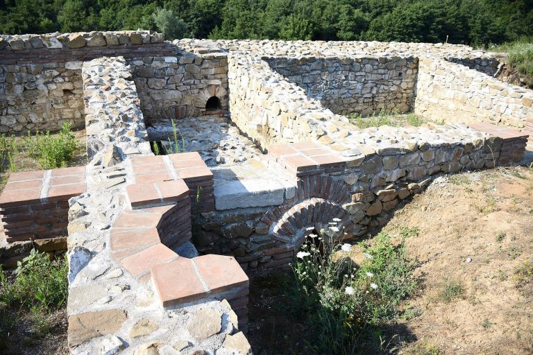
Floors were formed from local limestone clay mixed with animal dung and ash, creating a hard surface similar to concrete. Stone reinforcements along their edges supported the upper construction and show that the buildings were roofed. The exact form of the roofs remains uncertain. Proposed reconstructions include wattle arches, transverse or crossed arches, tripod-like structures, animal-hide coverings, and pyramidal or tent-like roofs.
House 57 and the Central House
House 57, assigned to Vir I-e, covered about 30 sq m and was later superimposed by House XLIV of Vir II. Covering 42 sq m, House XLIV is the largest excavated house and stood near the settlement’s center, giving it the name Central House. Its floor installation contained approximately seven to nine sculptures, depending on the inventory, or about 17 percent of the 52 sculptures counted in one catalogue. Among them were the Foremother, Danubius, Forefather, Progenitor, and Water Fairy. Houses 61 and 65 of Vir I were likewise superimposed by Houses XXXIV and XXXV of Vir II, illustrating the rebuilding of dwellings over successive phases.
Pit-houses and later furnaces
Pit-houses occur particularly in Vir III-a and III-b, phases associated with the Starčevo culture, although some may belong to Proto-Lepenski Vir. These dwellings were dug to the local frost line, no deeper than about 80 cm, using the ground’s stable temperature. Their walls were coated with mud, dried, and hardened by fire. At the related locality of Vlasac, natural funnel-shaped gullies were adapted as houses, demonstrating that construction methods responded to local terrain.
During the Starčevo phase, dome-shaped furnaces made from compacted earth were built on house floors. The largest measured approximately 1.5 m by 1.4 m by 0.5 m. Its size and position have led to proposals for communal use, although its proportions also correspond to those of House 49.
Hearths and ritual installations
Central floor arrangements
Every house contained a central floor installation set along its long axis. The arrangement included an elongated rectangular hearth, a shallow circular depression, stone elements, sculptures, and other features embedded in hardened porphyritic or red-plastered floors. Taken together, these elements often formed a human-like shape. The hearth was built from massive rectangular stone blocks and extended toward the rear of the building into a small shrine-like area. Large rounded river stones carved as sculptures stood in these areas and may have represented river beings, ancestors, or other ritual figures.
Hearths, depressions, and outer fireplaces
The central hearth was used for fire, with burning and ash preserved within it. Measurements from 51 houses give an average cavity about 78 cm long and 24 cm wide, generally 15 to 25 cm deep, with a length-to-width ratio of about 1:3.25. At least one quarter had sloping bottoms. Larger stones sometimes surrounded the hearth in two levels. In later Vir I phases, fewer stones were used, or they were replaced by triangular elements arranged in an ellipse. These triangles have been interpreted as supports, openings for offerings, symbols of fire or light, or heat vents.
A shallow circular depression often lay near the geometric center of the floor. Its possible functions include an altar, ash hollow, cult pit, sacrificial altar, support, heat vent, or receptacle for offerings. A pebble at the center created the head of the human-like floor arrangement. It may have served as a lamp, pouring vessel, roof-post support, or grinding surface for wild seeds or aromatic plants. An outer fireplace extended the interior installation at the entrance. It may have provided heat and protection from wild animals, while its large size allowed wood or logs to burn outside the small interior hearth.
Burials and material culture
Some people were buried beneath house floors, including children and probably prominent community members. Other burials formed an organized necropolis outside the settlement. In some cases the skull, mandible, and rest of the body were separated before being placed in different locations. Ceramic vessels filled with ash were also found and may have held ritual meaning.
The best-preserved skeleton came from House 69, in a shallow excavation associated with Proto-Vir or Vir Ia. Nicknamed Valentino, the individual died around 8200 BC and was estimated during modern facial reconstruction to have been about 55 years old, 178 cm tall, and 70 kg in weight. Other finds include stone, bone, and antler tools, objects made from wild-boar teeth, fishing equipment, and decorated pieces of stone, minerals, bone, antler, and tooth. Fish bones, stone weights or hammers, harpoons, hooks, net weights, and fish-shaped cobbles directly reflect the community’s fishing economy.
Stone sculptures
River-stone figures
Lepenski Vir produced approximately 52 to 54 stone sculptures, depending on the inventory used. The earliest belong to Lepenski Vir I-b, around 7000 BC, and sculpture continued through later layers of the Lepenski Vir culture. The figures were carved from rounded sandstone and other river cobbles gathered along the Danube. They include geometric forms and humanoid or anthropomorphic figures with strong brow arches, elongated noses, and broad fish-like mouths. Some also have stylized hair, beards, arms, and hands.
Because the sculptures were set into house floors, they formed part of the architectural installations rather than functioning solely as portable decoration. Most measure no more than about 60 cm, yet their size is exceptional for the period. They are among the earliest portrait-like sculptures and some of the earliest examples with carved mouths and ears. Their fish-like features and position in house shrines have encouraged interpretations involving river beings or river gods.
Foremother and Progenitor
The Foremother measures 51 by 39 cm and retains traces of red pigment, along with two openings on its shoulders. It has been interpreted as a possible female principle associated with fish-like beings and as a counterpart to the male-associated Danubius. The Progenitor is a 52 by 33 cm head, more human than fish-like in appearance, and has been interpreted as a possible totem. Red pigment survives around its eyes and on its neck.
In Vir I houses, sculptures and altar-like objects were usually placed behind the hearth, especially in the right wing when viewed from the entrance. In Vir II they occurred more often toward the front, indicating a change in spatial organization and ritual practice. In some Vir I and Vir II houses, sculptures lay on floors directly above people buried beneath them, connecting the house, sculpture, and funerary practices.
Modern protective structure
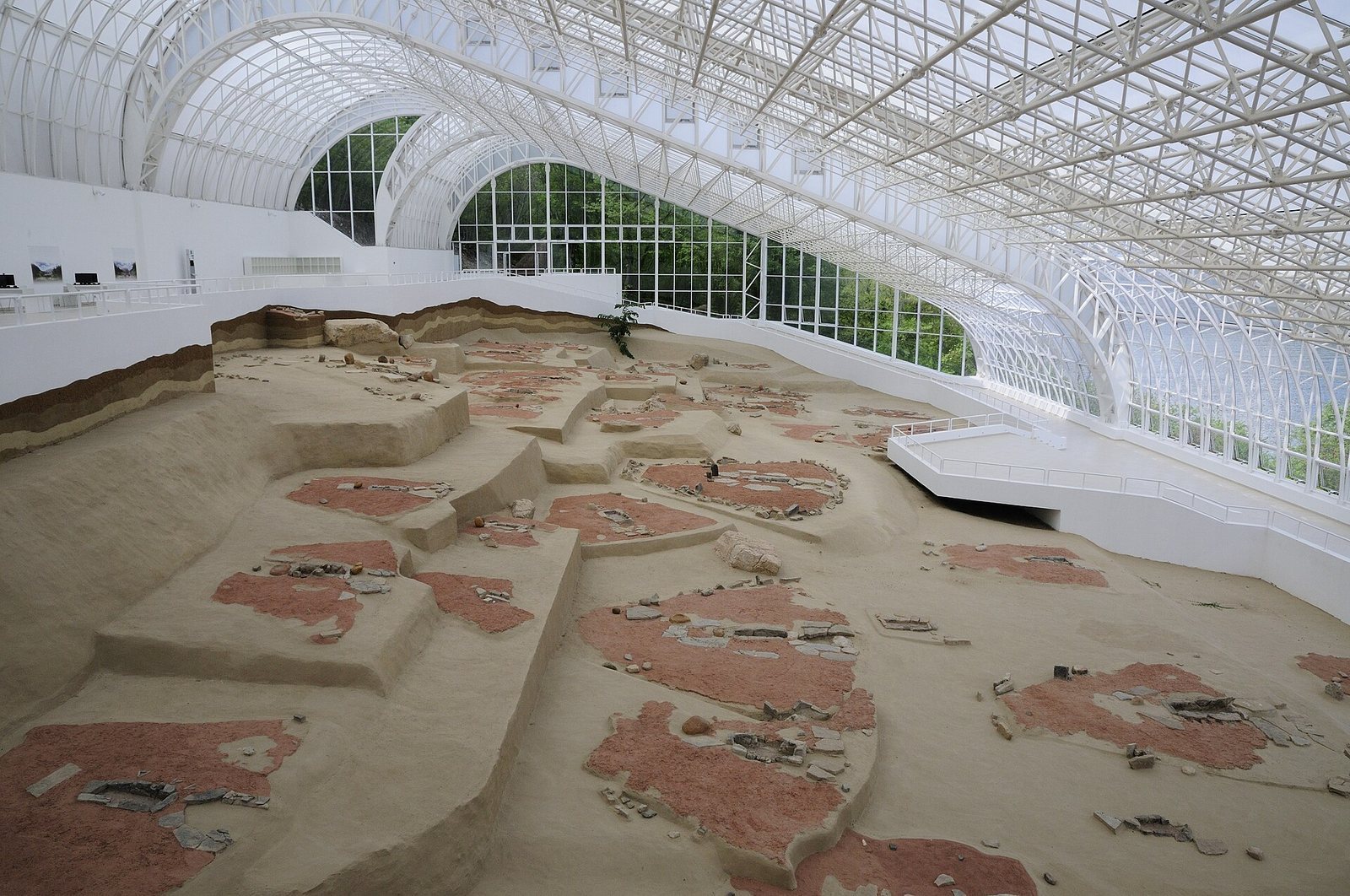
By December 2010, the earlier temporary timber-and-salonite shelter had been replaced by a large protective mesh structure. It follows the slope toward the Danube and was designed to preserve views toward Trescovăț. The reconstructed buildings presented at the visitor center represent one of several interpretations of the lost above-ground architecture. One model by Marija Jovin and Siniša Temerinski used a strongly inclined purlin, a horizontal roof-supporting member, removed the central post, and changed the direction of the roof carriers to create a slender structure intended to conduct smoke outward. Other reconstructions use tripods, crossed arches, or animal hides.