Lalbagh Fort: An Unfinished Mughal Fort in Dhaka
Site at a Glance
- Rating
- 4.5
- Popularity
- Very High
- Country
- Bangladesh
- Primary era
- Early Modern
- External website
- Open
- Eras represented
- Early Modern
- Civilizations
- Mughal
- Site type
- Military
- Remains
- Fort
On this page15 sections
History
Lalbagh Fort is an unfinished seventeenth-century Mughal fort in Dhaka, Bangladesh, built during the Mughal period as a fortified residence for the governor of Bengal. Construction began in 1678 under Prince Muhammad Azam Shah, the third son of Emperor Aurangzeb, while Azam served as Bengal’s provincial governor. The complex was originally called Fort Aurangabad, and the name Lalbagh, meaning “Red Garden,” was applied to the area and fort in 1844.
Construction under the Mughal governors
Azam remained in Bengal for about fifteen months before Aurangzeb recalled him to assist in the war against the Marathas. His departure left the project incomplete. Construction later continued under Shaista Khan, the Mughal governor of Bengal. Shaista Khan also used the fort as his residence, but he did not finish it.
The death of his daughter Iran Dukht, known as Pari Bibi, in 1684 appears to have changed his attitude toward the project. Shaista Khan came to regard the fort as unlucky and stopped the work. The complex also served as a place of custody, including for Europeans, although its primary purpose was connected with the residence and administration of the provincial governor.
Dhaka expanded and prospered under Mughal rule, encouraging the construction of palaces, mosques, mausoleums, and forts. After the capital of Bengal was transferred from Dhaka to Murshidabad, the city and Lalbagh Fort declined in prominence. The fort was abandoned after the end of Mughal rule.
Pari Bibi and later traditions
Pari Bibi’s identity is surrounded by competing traditions. She is widely regarded as Shaista Khan’s daughter and is said to have been engaged to Prince Muhammad Azam. Another interpretation identifies her as a nine-year-old princess from the Ahom kingdom, a state in the Brahmaputra Valley, who was taken during Mir Jumal’s expedition, converted to Islam, and married to Azam. This latter account remains debated.
The fort appeared in European paintings during the eighteenth and nineteenth centuries. Later traditions connected its sealed underground passages with soldiers attempting to escape during the 1857 Sepoy Rebellion, an uprising against British rule in India. The reported tunnel routes and deaths associated with these stories remain matters of legend.
Archaeology and conservation
Excavations by the Department of Archaeology of Bangladesh, including work carried out from 1994 to 2009, revealed structures beyond the three buildings traditionally associated with Lalbagh Fort. Investigations also traced the main fort walls eastward beneath Shaista Khan Road. These findings support the interpretation that the surviving enclosure represents roughly half of the larger complex planned by Azam.
The eastern half may have been intended for administrative use and associated with the Girde Qilla area, but it was left incomplete or disappeared long ago. The southeastern gate has consequently been interpreted as the central gate of the original plan. Restoration and conservation by the Department of Archaeology have helped preserve and present the surviving complex. Lalbagh Fort was placed on Bangladesh’s UNESCO World Heritage tentative list in 1999 under criteria (i), (ii), and (iv), and it is regarded as a recognized symbol of Mughal rule in Bengal.
Remains
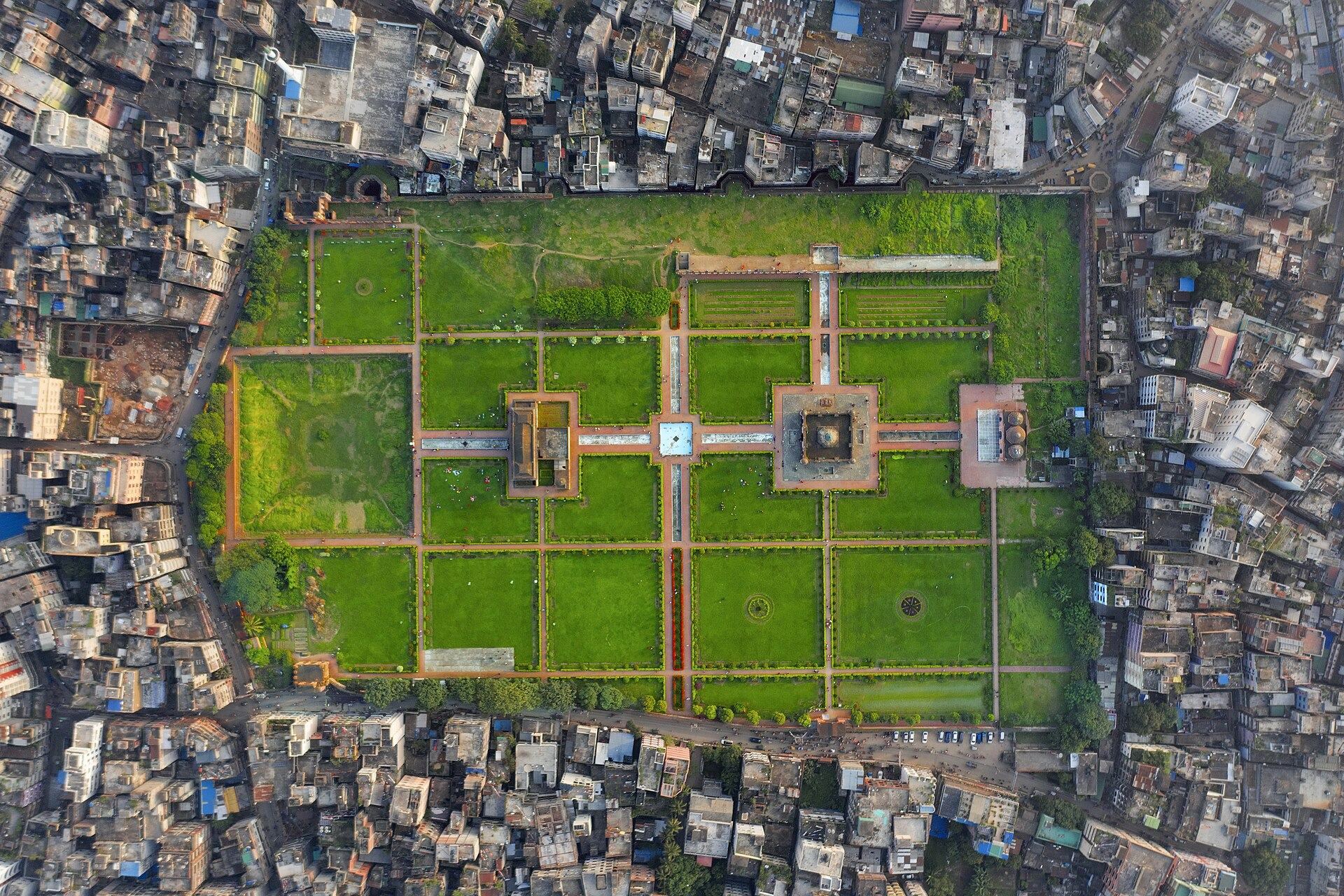
Lalbagh Fort occupies approximately seven hectares and combines fortifications, monumental buildings, service structures, gardens, water installations, and residential areas. Excavations have identified about twenty-six or twenty-seven structures. The principal buildings are arranged approximately along an east-west line, with the Diwan-i-Aam and attached hammam to the east, the mosque to the west, and the tomb of Pari Bibi between them. Water channels and fountains extend along both east-west and north-south axes.
Enclosure and water system
Fortifications and gates
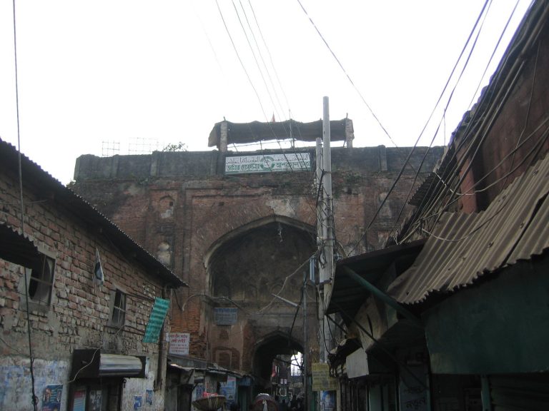
The southern fortification wall has a large bastion at its southwestern corner. The original southern wall had five regularly spaced, two-storey bastions, while the western wall had two. The largest western bastion stood near the principal southern gate. Underground passages or tunnels were incorporated into the bastions.
Two major monumental gates belong to the original plan, one at the northeast and another at the southeast. They were positioned within a fort intended to extend about 1,082 feet farther east. A third gate stands on the northern side, and two of the earlier entrances were designed as large arches. Some underground passages are now sealed. Tradition associates two of them with routes toward the ruined Zinzira Fort across the Buriganga River, while another was described as a maze-like passage.
Water tank and channels
A square water tank lies east of the Diwan-i-Aam. Each side measures approximately 71.63 metres, and four stairways at the corners descend into it. Channels carrying water and regularly spaced fountains connected the main buildings along the two principal axes of the complex. A roof garden with fountains and a water reservoir occupied part of the western section, while the fort also contained other water-supply installations.
Principal buildings
Diwan-i-Aam and hammam
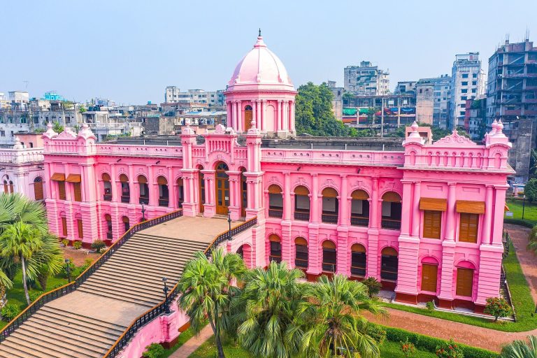
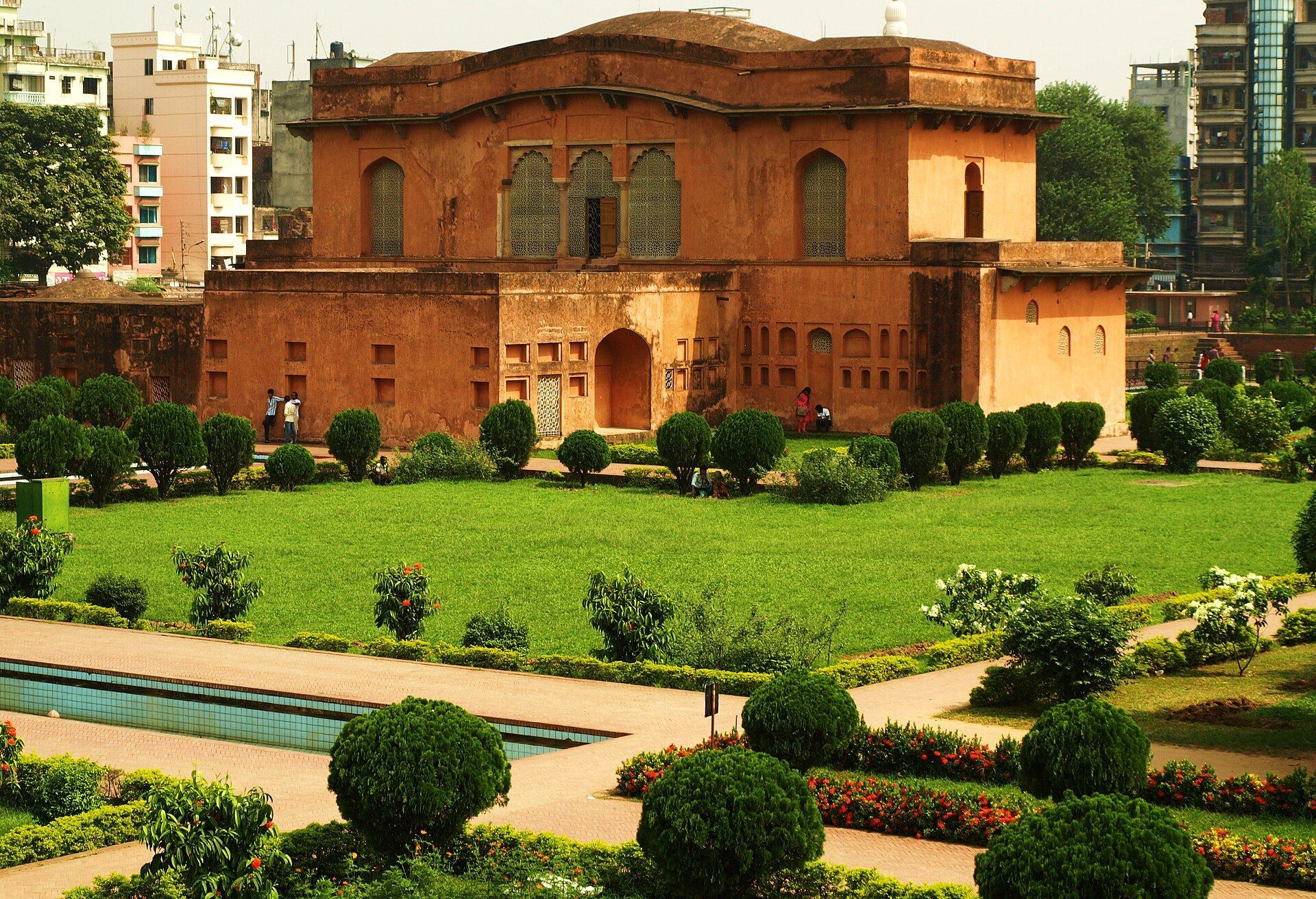
The Diwan-i-Aam, a public or administrative audience hall, is a two-storey building on the eastern side of the fort. Living quarters occupy both levels, with a central hallway connecting them. The building measures approximately 32.47 by 8.18 metres externally and stands about 39 metres west of the water tank.
A single-storey hammam, or heated bath complex, is attached to its western side. The southern section contains a Hammamkhana, the bathhouse area, along with an underground room for heating water, a toilet, and a long partition wall along the western facade. Excavation beneath the Hammamkhana uncovered a heating installation and specially made terracotta pipes for hot and cold water. Blackened areas in the underground room indicate that fire was used to heat the water.
Tomb of Pari Bibi
The tomb of Pari Bibi stands at the centre of the complex. Her remains lie in a central square chamber beneath a false octagonal dome and a brass covering. White marble faces the interior walls. Eight surrounding rooms enclose the central chamber, and a smaller grave occupies the room at the southeastern corner.
Mosque
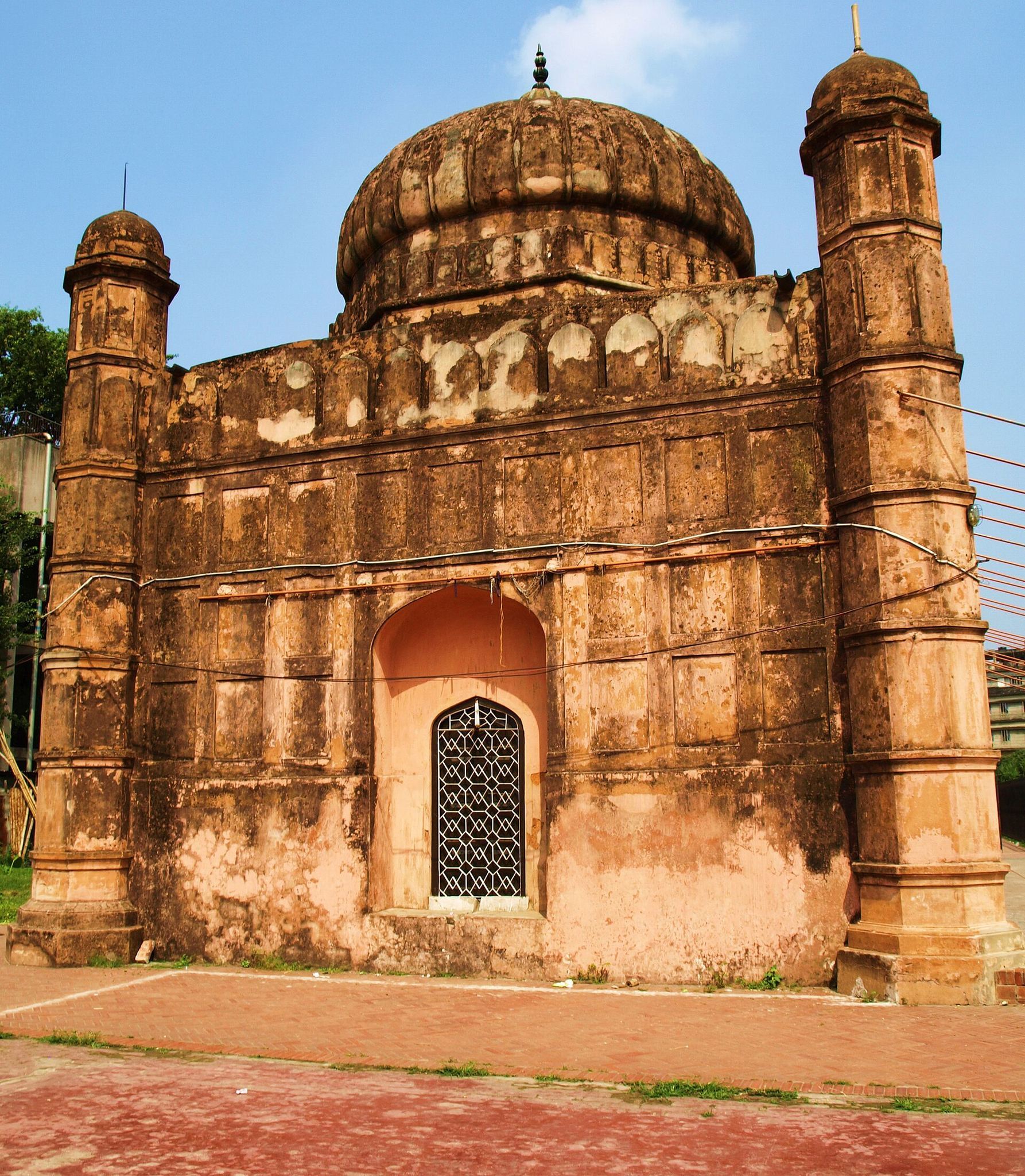
The mosque is a comparatively small, three-domed building on the western side of the central arrangement. An ablution tank stands in front of it. The mosque measures approximately 20.34 by 10.21 metres externally and about 16.36 by 6.15 metres internally.
Service areas and landscape features
Utility and administrative buildings
The northern side of the southern fortification wall contained utility buildings, a stable, and an administrative block. Residential areas lay east of the western fortification wall, principally to the southwest of the mosque. Excavations have also revealed gardens, fountains, and other structures connected with the operation of the fort.
River setting and artillery
Several pieces of artillery are kept within the fort. The complex formerly stood beside the Buriganga River, but the river has since retreated from its vicinity. This altered relationship forms part of the physical setting in which the surviving fort is understood.