Klingenberg Castle Ruins: A Medieval Hilltop Fortress in Austria


Site at a Glance
- Rating
- 4.2
- Popularity
- Very Low
- Country
- Austria
- Primary era
- Medieval
- Eras represented
- Medieval
- Civilizations
- Duchy of Austria, Holy Roman Empire
- Site type
- Military
- Remains
- Castle
On this page8 sections
History
Klingenberg castle ruins are the remains of a hilltop fortress in Austria, near St. Thomas am Blasenstein. Built by the Lords of Perg and Machland, the castle probably dates from the 11th or 12th century, although its exact construction date is uncertain. Its position on a wooded summit made it part of the medieval defensive landscape of the region, with sight lines toward Clam Castle and Ruttenstein Castle.
Early lords and ducal possession
The Lords of Perg and Machland traditionally appear as Klingenberg’s builders and early occupants. Through inheritance, the castle passed to the Clam-Velburg family. Their last heir, Count Ulrich, failed to return from the Damietta Crusade in 1217, after which Klingenberg passed to Duke Leopold VI, a Babenberg ruler of Austria and Styria.
A ducal land register compiled between 1220 and 1240 lists 13 fiefs and six farmsteads belonging to the Klingenberg lordship. The property remained in ducal hands as authority passed from the Babenbergs through Ottokar Přemysl, the king of Bohemia who also controlled Austria for a period, and ultimately to the Habsburgs.
Pledges and changing holders
In 1276, King Rudolf I pledged Klingenberg as the dowry of his daughter Katharina when she married Duke Otto of Bavaria. After Katharina’s death, Duke Albert I recovered the lordship and later pledged it to the Lords of Walsee, who held the castle until 1358. Duke Albert II redeemed the pledge that year, but soon afterward transferred the castle as security to Hans von Traun, the captain responsible for the territory above the Enns.
In 1395, Duke Albert III granted Klingenberg to the brothers Wenzel and Ernst Preuhafen for their lifetimes. In return, they surrendered other properties and accepted responsibility for maintaining the castle. The pledged possession later passed to the Rohrbacher family in 1433, then to the Neudeckers, the Liechtensteiners until 1490, the Schneckenreuters, and the Prüschenks from 1491. In 1500 it went to Laßla Prager, who was associated with the County of Windhaag. Achaz von Losenstein received it in 1524, followed by the Steyr citizen Georg Kremser in 1527 and Sebastian Kremser in 1536.
From private lordship to decline
On 10 August 1588, Lorenz Schütter acquired the Klingenberg lordship together with the market and parish of Münzbach. The transaction was made under a contract with Emperor Rudolf II for 12,204 guilders, 6 pounds, and 20 denarii. Schütter had paid the sum from his own funds into the Vienna vice-dominal office on 19 March 1588, and Archduke Maximilian conveyed the property to him as a hereditary freehold.
Klingenberg was listed among the fortified places selected as refuges in 1594 because of the Ottoman threat. In 1630, however, Schütter’s successors sold Klingenberg and Münzbach to the Waldhausen monastery of Augustinian Canons. The monastery removed the administrative function from the castle, after which the complex declined and was occupied mainly by gatekeepers. In 1750, the lordship comprised 47 subject houses. Fire and lightning hastened the deterioration, although officials occasionally continued to live in the castle.
After Emperor Joseph II dissolved Waldhausen monastery, the lordship, castle, manor farm, and associated forest passed to the Linz Cathedral Chapter, the body of canons administering Linz Cathedral and its property. The chapter remains Klingenberg’s owner. Part of the keep collapsed in 1855, while poorer inhabitants continued to live in the castle into the 20th century. The complex then deteriorated completely into a ruin.
Since 2010, a private initiative has cleared heavy tree growth, secured the remains, and undertaken repairs. Josef Strasser, chairman of the Association of Klingenberg Ruins, is identified as the site’s “castle lord.”
Remains
Fortified terraces
Klingenberg occupies a wooded summit at approximately 700 metres above sea level, roughly equidistant from St. Thomas am Blasenstein and Pabneukirchen. Built entirely of stone blocks, the fortress covered 3,061 square metres within its enclosed boundaries. Its highest point lies to the west, where the keep rises above the woodland and surviving ruins. Three fortified levels descend southeastward in a sequence of terraces, carrying the main castle and two outer baileys.
Keep and high castle
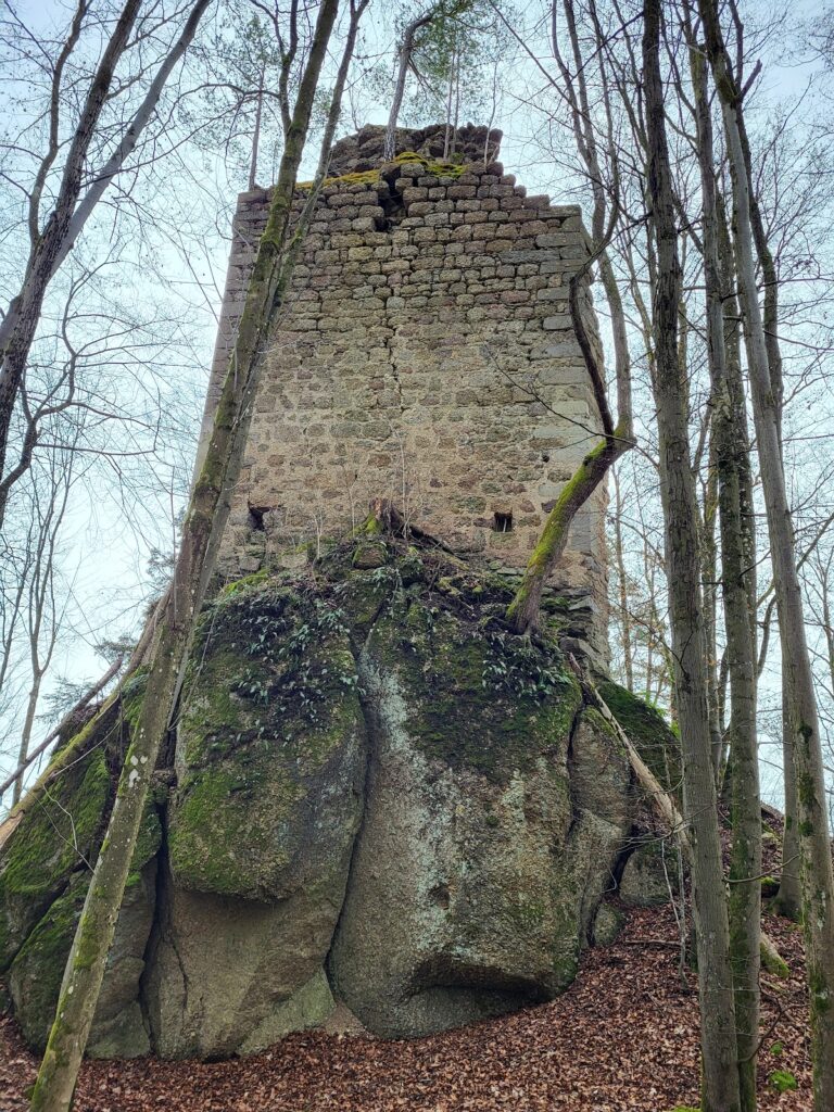
The keep retains high wall sections, although its southern half collapsed in 1855. A wooden stairway was inserted in the collapsed area during later stabilization work. Beside the keep, the uppermost terrace formed the Romanesque high castle, or main castle. It contained the palas, the principal residential and representational building, together with rooms for the lord and castle administrator. A kitchen with a baking oven served the complex, while a cistern measuring 8.30 metres deep and up to 4 metres wide could hold 44,000 litres of water. The Romanesque entrance gate stood at the eastern corner of the high castle.
The northwest wall of the palas collapsed in June 2013. The failure also carried away the corbels that supported the wall walk and latrine, and water penetration was identified as the cause. The collapse forms part of the recent physical history of a ruin whose surviving walls have required continued stabilization.
Outer baileys
The middle terrace was the upper Gothic outer bailey, an enclosed subsidiary area outside the main castle. It contained a large level courtyard and its own well, traditionally said to have originally reached 118 metres in depth. Entrance buildings stood somewhat below the western corner, beside a Gothic entrance gate and drawbridge.
The lowest terrace formed the lower outer bailey. Its working buildings included a forge and stables, and it also provided a rear exit. A Renaissance entrance gate stood at the western corner, although only its earth bank survives. Together, the two outer baileys extended the fortified complex down the southeastern slope from the keep and high castle.
Nearby sites