Hōraiyama Kofun: A Keyhole-Shaped Burial Mound in Japan


Site at a Glance
- Rating
- 4.2
- Popularity
- Low
- Country
- Japan
- Primary era
- Classical
- External website
- Open
- Eras represented
- Classical
- Civilizations
- Yamato
- Site type
- Burial
- Remains
- Burial Mound
On this page13 sections
History
Hōraiyama Kofun is a large keyhole-shaped burial mound in Japan’s northern Nara Basin, west of the Nara urban area. Built during the early to middle fourth century, probably around AD 340–360, it belongs to the Kofun period, an era of monumental elite tombs and expanding regional political authority. Its scale has led to the view that it may have been constructed for a major ruler of the Yamato polity, an early political authority based in the Kinai region, including the Nara Basin. The individual buried there, however, is unknown.
Construction and political setting
The mound forms part of the sequence of major tombs in the northern Nara Basin. It is generally placed later than Saki Misasagiyama Kofun and earlier than Saki Ishizukayama Kofun and Gosashiyama Kofun. Some interpretations include it and nearby smaller circular mounds within the southern subgroup of the Saki Kofun Group, although this classification is not universally accepted.
Its date has been refined through haniwa fragments collected during maintenance work. Haniwa are clay objects placed on or around burial mounds, with cylindrical examples often forming rows or boundaries and representational examples depicting buildings, objects, animals, or people. The fragments place Hōraiyama Kofun in the early stage of an early-to-middle fourth-century typological phase. Earlier interpretations placed its construction after Shibutani Mukaiyama Kofun, while pottery from the nearby Sugawara-higashi site has increased the possibility that Hōraiyama was built earlier.
Imperial identification and later traditions
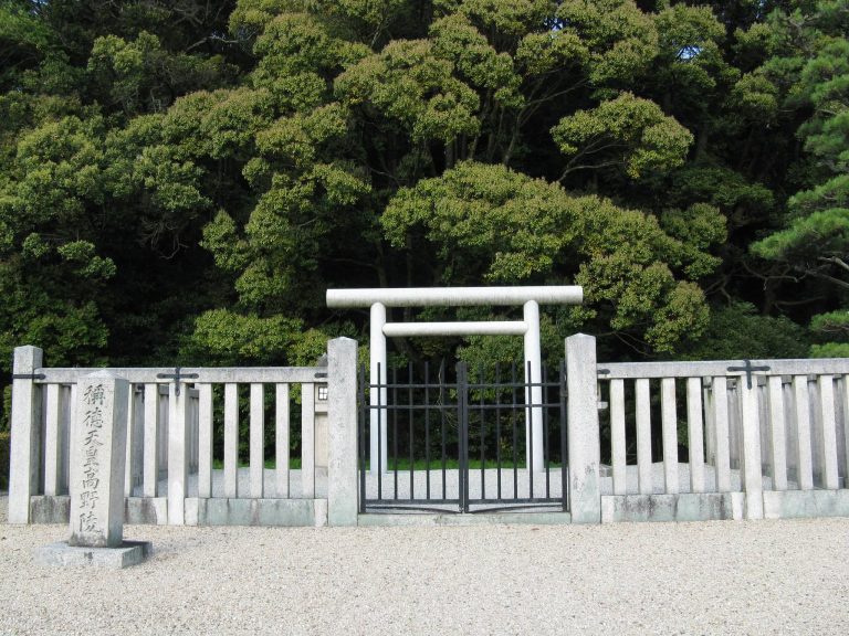
The Imperial Household Agency officially identifies Hōraiyama Kofun as the tomb of Emperor Suinin, the traditionally numbered eleventh emperor, under the designation Sugawara Fushimi East Tomb. The identification is a matter of imperial tradition rather than a confirmed archaeological attribution. Historical records indicate that the mound was also called Hōraisan, and it was robbed in 1849.
The association with Suinin emerged during the Edo period. In the Genroku era, conventionally dated to 1688–1704, the Nara magistrate’s office identified Hōraiyama as the emperor’s tomb. An earlier interpretation connected the mound with Prince Nittabe, a son of Emperor Tenmu. A proposal made in 1906 instead identified a detached mound called i-go, or Hyogoyama, as the prince’s tomb.
The imperial attribution has also been linked to the Haji clan, an ancient lineage traditionally associated with the production of haniwa and other burial-related crafts. Its ancestral territory lay near the mound, while traditions connected Emperor Suinin with haniwa. Another interpretation concerns Emperor Anko. Because ancient records give similar names for the tombs of Suinin and Anko, some have suggested that the structure now identified as Anko’s tomb may instead be the detached mound near Hōraiyama.
The wider imperial tradition remains difficult to reconcile with the archaeological sequence. The locations assigned to the tombs of Emperors Sujin, Suinin, and Keiko do not fit the expected political and chronological development of the region, and the transmission of Suinin’s tomb tradition may have become confused. These uncertainties leave Hōraiyama Kofun important as a major fourth-century monument while preventing a secure identification of its occupant.
Associated areas and modern investigation
The Imperial Household Agency recognizes seven associated mound areas: an island mound within the moat and six detached areas designated i-go, ro-go, ha-go, ni-go, ho-go, and he-go. Archaeological interpretation suggests that Hōraiyama may originally have had no formal subsidiary mounds, despite the official grouping of these areas.
The mound later lay within the western capital district of Heijo-kyo, the eighth-century capital established in the Nara Basin. Its planned streets and administrative districts extended across or near earlier archaeological features. Since the Meiji period, its identification as an imperial tomb has restricted full-scale archaeological investigation. Modern work has therefore consisted largely of observation and sampling during maintenance and improvements, especially from the 2000s onward. These investigations produced haniwa fragments that helped refine the mound’s date.
Remains
Hōraiyama Kofun is a three-tiered keyhole-shaped mound with its rectangular front section facing south. It measures approximately 227 meters in length, although one interpretation estimates an original length of about 240 meters because the present water level in the moat may be higher than it was when the mound was built. Including the surrounding moat, the monument extends for about 330 meters.
Main mound and moat
Stepped burial mound
The circular rear section is about 123 meters in diameter and rises 17.3 meters high. Its three stepped levels are explicitly described, while the rectangular front section is also formed in three tiers, measuring about 118 meters across and 15.6 meters high. The exterior slopes were covered with fukiishi, stones laid over an earthen mound to help protect it from erosion and provide a finished surface. Haniwa stood on or around the mound, including cylindrical examples and representational pieces in shield, house, and quiver forms.
Moat and southeastern island
A keyhole-shaped moat surrounds the mound. It is regarded as an early example of a moat forming one continuous body of water around the entire monument. In a later period, the southeastern part was enlarged for irrigation. Part of the former outer embankment consequently remained as an island in the water.
The island is approached from a worship area on the opposite bank. Archaeologically, it is interpreted as a surviving section of the earlier embankment. Another interpretation treats it as a preserved mound associated with the tradition of Tachibana no Moroe, an eighth-century court noble and political leader. Older Edo-period plans and a Meiji-period plan of the imperial tomb do not show the island, supporting the interpretation that it resulted from the later enlargement and partial removal of the embankment.
Burial chamber
Descriptions made after the Edo-period robbery refer to a pit-type stone burial chamber containing a long chest-shaped stone coffin. Because the tomb has not undergone full internal archaeological investigation, this description derives from the historical account of the robbery rather than from modern excavation inside the mound.
Detached mounds and surrounding evidence
I-go, or Hyogoyama
The detached area called i-go lies about 200 meters northwest of Hōraiyama Kofun. It is a large circular mound approximately 40 meters in diameter. Its southern side is associated with the projected line of Sanjo Avenue in Heijo-kyo. During the Edo period, the mound was associated with a shrine to Gozu Tenno, a syncretic deity traditionally connected with protection from epidemic disease. Later traditions identified it as the tomb of Emperor Anko, while the 1906 interpretation associated it with Prince Nittabe.
Other detached areas
The area called ro-go lies west of the junction between the circular rear section and the rectangular front section. Its details are unclear, although it may itself be a burial mound. The areas called ha-go and ni-go lie south of the main mound and east of its rectangular front section respectively. Both may be ancient burial mounds, but their contents remain unknown. The areas designated ho-go and he-go lie east of the circular rear section and northeast of the principal mound, and their details are also unclear.
Hiramatsu-Kitauchi mound site
West of the circular rear section, the Hiramatsu-Kitauchi mound site has been levelled. Its remains include a ditch, part of a house-shaped haniwa, and a cylindrical haniwa with a projecting fin. Farther west, a circular division of land may mark another destroyed kofun, a monumental Japanese burial mound. Together, these features have supported the interpretation that subordinate small burial mounds once surrounded Hōraiyama Kofun.