Roman Villa Archaeological Site of Fuente Álamo: A Roman Estate and Bathing Complex in Spain


Site at a Glance
- Rating
- 4.7
- Popularity
- Low
- Country
- Spain
- Primary era
- Classical
- External website
- Open
- Eras represented
- Classical, Medieval
- Civilizations
- Roman, Umayyad, Visigothic
- Site type
- Domestic
- Remains
- Villa
On this page17 sections
History
The Roman Villa Archaeological Site of Fuente Álamo is a Roman archaeological complex in Spain, near Puente Genil, whose earliest known phase was a first-century bathing establishment later incorporated into a rural villa. Located beside the Fuente Álamo stream in the Los Arenales natural area, the site benefited from flowing water and fertile land. In Roman times, it lay within the Astigitanian juridical district, an administrative territory centered on Astigi, modern Écija, and near a branch of the Via Augusta leading toward Antikaria, now Antequera.
The Roman bathing complex
The first installation at Fuente Álamo was a bathing complex dating from the first century AD. It provided facilities for recreation, bathing, and hygiene, probably serving people from nearby urban settlements as well as travelers using the regional road network. Its position between Ipagrum, modern Aguilar de la Frontera, and Ostippo or Astapa-Ostipo, modern Estepa, placed it within a wider network of Roman communities and roads.
The baths were abandoned around the second half of the second century or the beginning of the third century AD. Flooding may have damaged the water channels or the eastern walls. A short period of partial abandonment followed before a residential and agricultural villa was built over the earlier installations.
Expansion of the villa
The villa had been established by the third century AD and later expanded substantially. It combined a pars urbana, the elite residential sector of a rural estate, with a pars rustica, the working and agricultural area. Grain, wine, and oil were probably among the products stored or processed there. Two main construction phases can be identified. The first created most of the residential and agricultural complex. During the middle of the fourth and the early fifth centuries, the buildings were enlarged, floors were raised, and further rooms were added, possibly including a mithraeum, a sanctuary associated with the Roman cult of Mithras, or a tablinum, a formal reception room.
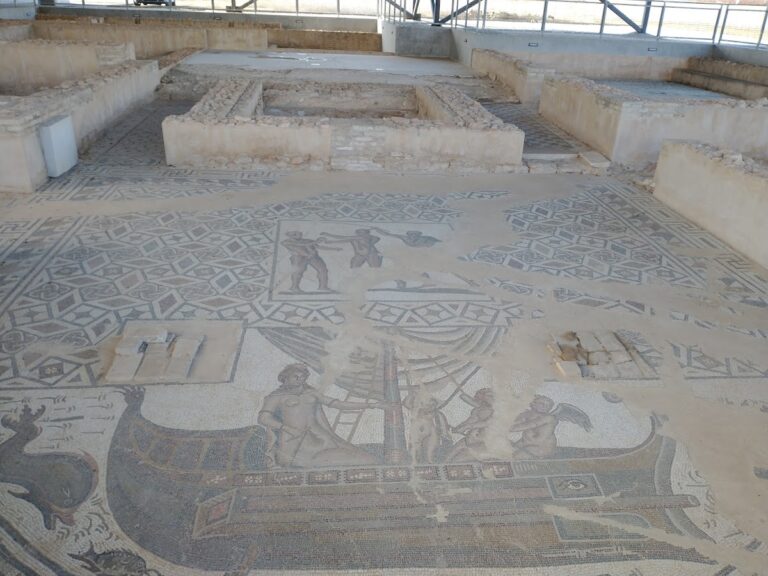
The villa reached its greatest prosperity and luxury at the end of the fourth and during the fifth century AD. This period saw the installation of elaborate polychrome mosaics, including mythological compositions that now form the central part of the site’s historical interpretation.
Decline and later Roman-period occupation
From the late sixth century, the villa entered a period of decline. Some rooms remained in limited use during the Visigothic period and the beginning of the early Middle Ages, while others were adapted for agricultural and pastoral purposes. This change followed the political and economic instability that accompanied the disappearance of the Western Roman Empire, later Visigothic incursions, and attempted Byzantine expansion along the Mediterranean coast of the Iberian Peninsula.
A small exagium, a standardized Byzantine weight used when weighing valuable goods or coinage, has been interpreted as evidence of at least a secondary Byzantine presence at the site. The later occupation therefore reflects continued activity during a period when political authority and economic organization were changing across southern Iberia.
Islamic-period reuse and abandonment
Following the Islamic conquest of the Iberian Peninsula in AD 711, Muslim communities reoccupied Fuente Álamo from the eighth century. Ceramics from the Emirate period in the upper levels indicate an early Islamic occupation and the reuse of existing structures and infrastructure. During the Caliphate period, farming and economic activity continued, and an oil mill was installed in the northern part of the complex. Several Roman rooms were remodeled for the needs of the new inhabitants.
The final abandonment cannot be dated precisely because later archaeological information has been lost from the upper levels. The latest habitation remains belong to the end of the eleventh or the beginning of the twelfth century, establishing that occupation continued until at least that period. Afterward, flooding and erosion caused buildings to collapse and become gradually buried beneath alluvial sediments. The stream destroyed much of the central area, including parts of the earlier bathing complex, while the same deposits helped protect other structures.
Rediscovery and archaeological investigation
The land continued to be used agriculturally in modern times. From about the seventeenth century, the Fuente Álamo stream was channelled to supply Puente Genil and also served as a watering place for livestock.
Local interest grew in the late nineteenth and early twentieth centuries, when Antonio Aguilar y Cano recorded surface remains and drew mosaics and other objects. Scientific archaeological work began in the 1980s and 1990s, when Alberto López Palomo carried out emergency excavations in areas threatened by farming, looting, and destruction. A broader excavation and valorization project began at the start of the twenty-first century under López Palomo’s direction. It clarified the site’s successive construction and occupation phases and led to the creation of its present visitor and museum facilities. Excavations also examined the necropolis and remains beyond the currently accessible complex.
The archaeological complex is managed by the municipality of Puente Genil with an interdisciplinary archaeological team. It has been protected as a Spanish Bien de Interés Cultural since 2005.
Remains
The excavated complex covers at least 4,000 square metres, although the complete villa was probably larger. Buildings stood on both sides of the Fuente Álamo stream. The earlier bathing establishment was divided between the two banks, while the later villa incorporated parts of it and was arranged with unusually thick enclosing walls to reduce the danger from flooding. A small dam upstream controlled the stream’s flow and helped maintain a continuous water supply. The site lies in the Campiña Alta, where elevations range from about 100 to 300 metres above sea level, and local building materials were largely obtained from the surrounding geological environment.
The bathing complex
Cold-water facilities
Cold-water installations occupied the right bank of the stream. In its western area, two reservoirs with several construction phases regulated water flow toward a larger pool. This pool, identified as a frigidarium, or cold-water room or pool, had a curved plan extending beyond 180 degrees. It measured 16 metres across and held an estimated 200 cubic metres of water. A continuous internal bench allowed bathers to sit with the water reaching approximately neck height.
The open pool was bordered by a corridor supported by brick columns and covered by a single-pitched roof. Two smaller rooms surrounded it and belonged to different building phases. Their floors and the floor of the pool carried polychrome geometric mosaics. The walls were made from rammed earth, coated with stucco, and painted on both sides, with multicoloured decoration inside and a single colour outside.
On the eastern side of the same bank stood a rectangular natatio, or swimming pool, ending in an apse. It measured approximately 18 by 6.3 metres, reached a maximum depth of about 1.5 metres, and held an estimated 173.5 cubic metres of water. Its walls used opus incertum, a Roman technique employing irregular stones set in mortar, and the southern and western sides were later reinforced. The curved pool of the bathing complex has been described as unique among known Roman villas and bathing installations in the Iberian Peninsula.
Hot-water facilities
Hot-water rooms occupied the left bank. They include a well-preserved hypocaustum, an underfloor heating system, together with a praefurnium, the furnace that supplied it, a caldarium, or hot room and bath, and several hot-water pools. Beside these facilities was a feature interpreted as a nymphaeum, a monumental water feature associated with nymphs. It consisted of stepped pools extending for at least 14 metres and probably created cascades and fountains visible from the cold-water pool and the swimming pool.
The villa’s residential and agricultural areas
Agricultural and storage buildings
The northern wing formed the pars rustica. It contained a large storehouse, smaller attached storage rooms, and horrea, storage buildings intended especially for grain and other agricultural products. The storage buildings were raised above the floor and fitted with ventilation ducts that circulated hot air. This arrangement helped maintain dry conditions and protected grain from fermenting.
The villa was constructed over and partly absorbed the earlier baths. Some earlier structures were dismantled or covered, while their building materials were reused elsewhere. Later, following the villa’s decline, rooms were converted into stables and enclosing walls were built for livestock. Domestic hearths with rectangular bases were placed over the floors of important rooms, using material taken from walls and columns.
Residential rooms and circulation
The pars urbana extended along a north-south axis. Its central area contained a large room whose function remains debated between a cult space and a study or reception room. At the western end, the oecus, a large reception or ceremonial room, was built over the walls of the earlier cold-water pool and nearby rooms. Private rooms, or cubicula, lay between the oecus and the central room, while a broad covered corridor linked the principal spaces.
The southern part of the villa was connected across the stream by a gallery approximately 38 metres long. Another corridor, nearly 30 metres in length, led to rooms on the opposite side. Later flooding damaged this area, making its arrangement harder to understand. The former agricultural wing was also altered by the installation of an oil mill during the Islamic period.
The tetraconch hall
A preserved tetraconch hall, a room with four apses arranged around a central space, has a cruciform plan formed by a square centre and semicircular apses on each side. It is described as the only known example of its kind in Baetica, the Roman province that covered much of present-day Andalusia.
The hall’s pavement depicts a Nile scene with the river god and episodes of pygmies fighting cranes they intended to hunt. Inscriptions accompanying the figures add humorous and partly erotic details to the composition.
The oecus and mythological mosaics
The oecus contains some of the villa’s most elaborate decoration. One pavement, known as the Three Graces mosaic, presents three scenes. Pegasus is shown being fed by a nymph, the Three Graces, Aglaea, Euphrosyne, and Thalia, appear to dance, and a satyr pursues a nymph.
The central mosaic of the room represents the Triumph of Bacchus, the Roman god of wine, ecstasy, and festivity. Its lower scene shows Bacchus’s conquest of India, with satyrs and nymphs attacking Indians who offer unsuccessful resistance. Above them, Bacchus rides in a chariot drawn by tigresses, accompanied by Silenus, his aged tutor and companion, and Pan, a pastoral god. Ariadne, his mythological consort, appears beside him.
An apsidal pavement carries a shell or scallop design divided into 28 segments and ending in wave forms. A border of spiralling acanthus scrolls frames the composition. Geometric and polychrome pavements occur throughout the residential rooms and corridors, while the figurative mosaics are considered exceptional within Roman Hispania and the wider Roman Empire.
Nilotic decoration
A second Nilotic mosaic from the southern area was laid over the foundation of the caldarium and may have decorated the villa’s sauna. Its figures are shown in dialogue, an unusual treatment of this subject. The original is deposited in the Archaeological Museum of Córdoba for security, while an exact reproduction is displayed at the villa. Drawings made by Antonio Aguilar y Cano also preserve knowledge of mosaics affected by later looting and deterioration.
Necropolis and landscape
A large necropolis extends beyond the excavated complex. Its burials span the site’s occupation from the Roman period through the final Islamic phases, and burial types and grave goods reflect this chronological range. Three hundred individuals have been exhumed.
The stream channel is now generally dry because of severe drought and the depletion of underground water resources, although water can appear in the natural channel after heavy rainfall. Its long relationship with the settlement shaped both the site’s original water systems and the later preservation of its buried remains.